


Services on Demand
Journal
Article
 English (pdf)
 Article in xml format
 Article references
 Send this article by e-mail
Indicators
-
 Cited by SciELO
 -
 Access statistics
Related links
-
 Cited by Google
 -
 Similars in
SciELO
Similars in
SciELO -
 Similars in Google
Share

 Permalink
Revista Facultad Nacional de Agronomía Medellín
Print version ISSN 0304-2847
Rev. Fac. Nac. Agron. Medellín vol.69 no.1 Medellín Jan./June 2016
https://doi.org/10.15446/rfna.v69n1.54746
DOI: http://dx.doi.org/10.15446/rfna.v69n1.54746
Estimation of greenhouse gas emissions from agricultural activities in the Aburra valley Metropolitan Area - Colombia
Estimación de las emisiones de gases de efecto de invernadero generados por actividades agrícolas en el Área Metropolitana del Valle De Aburrá - Colombia
Deicy Catalina Guerra García1, Jairo Alexander Osorio Saraz1, Rolando Barahona Rosales1
1 Facultad de Ciencias Agrarias - Universidad Nacional de Colombia. A.A. 1779, Medellín, Colombia. <rbarahonar@unal.edu.co>
Received: May 23, 2015; Accepted: November 18, 2015
This work is licensed under a Creative Commons Attribution-NonCommercial-NoDerivatives 4.0 International License.

ABSTRACT
The aim of this study was to estimate emissions of greenhouse gases (GHG) generated by the agricultural activities carried out in the Metropolitan Area of the Aburrá Valley (AMVA), located in Medellin - Colombia. A TIER 1 approach of the methodology of the Intergovernmental Panel on Climate Change, IPCC was followed. Emissions of GHG from cropland, aggregate sources and non-CO2 emissions from land were estimated and analysis of the uncertainty of activity data and emission factors were made. The estimated total emission was 63.1 and 66 Gg CO2 eq for 2009 and 2011, respectively. The greatest contribution to greenhouse gases in agricultural production was the application of nitrogen to soils in the form of synthetic and organic fertilizers, which was associated with direct and indirect N2O emissions. The main sources of uncertainty were those derived from the activity data.
Key words: Agricultural production, Gases emissions, Fertilization, Global warming, Greenhouse effect, Uncertainty estimation.
RESUMEN
El objetivo de este estudio fue estimar las emisiones de gases de efecto invernadero (GEI) generados en la producción agrícola del Área Metropolitana del Valle de Aburrá (AMVA), Medellín - Colombia. Para esto, se usó la metodología del Panel Intergubernamental de Expertos sobre el Cambio Climático, IPCC siguiendo una aproximación TIER 1. Se estimaron las emisiones de GEI en tierras d e cultivo, fuentes agregadas y emisiones de gases diferentes a CO2 a partir de tierras, y se hizo análisis de la incertidumbre a los datos de actividad y factores de emisión. La emisión total estimada fue de 63,1 y 66 Gg CO2 eq para 2009 y 2011, respectivamente. El mayor aporte a los GEI en la producción agrícola fue la aplicación de nitrógeno a los suelos en la forma de fertilizantes sintéticos y orgánicos, que estuvo asociada con emisiones directas e indirectas de N2O. Las principales fuentes de incertidumbre fueron aquellas derivadas de los datos de actividad.
Palabras claves: Producción agrícola, Emisiones de gases, Fertilización, Calentamiento global, Incertidumbre.
In 1992, the UN Framework Convention on Climate Change (UNFCCC) recognized that human activities have contributed to the substantial increase in atmospheric concentrations of greenhouse gases, intensifying the natural greenhouse effect and contributing to an additional warming of the Earth, which may adversely affect natural ecosystems and human welfare (UN, 1992). Today, scientific reports of increased ocean temperature and air worldwide, melting glaciers, declining ice caps and rising sea levels are becoming more frequent. Between 1900 and 2005, there has been increased precipitation in eastern North and South America, Northern Europe and Northern and Central Asia, while it has decreased in South Africa, the Mediterranean and South Asia. Despite efforts to reduce emissions, the Fourth Assessment Report Climate Change (AR4; IPCC, 2007) reported that the total annual emissions of greenhouse gases (GHGs) have continued to grow. In 2010, these emissions totaled 49.5 Gt of carbon dioxide equivalent (CO2 eq), a value never observed before (Working Group II, IPCC, 2014).
Although not high, emissions from Colombia and Latin America contribute to the global pool of GHG emissions. In 2004, Colombia emitted 0.18 Gt of CO2 eq, whereas US and EU emissions were 6.2 and 3.9 Gt of CO2 eq, respectively (IDEAM, 2009). In 2002, Mexico had emissions of 0.5 Gt of CO2 eq (Instituto Nacional de Ecología, 2004) and in 2000, Argentina emitted 0.2 Gt of CO2 eq, (Secretaría de Ambiente y Desarrollo Sustentable, 2007). Thus, it is necessary to implement measures to reduce GHG emissions, increase mitigation and allow adaptation to climate change, which must come from policies and actions at the local, regional and national level. Together with the generation of new technologies, a change must occur in human behavior and consumption patterns (Working Group II, IPCC, 2014).
Although Colombia has conducted two National Greenhouse Gas Inventories, there have been few instances of initiatives at the regional level to determine the contribution of these regions to national GHG emissions (Echeverri, 2006; Pulido, 2012). In 2009, it was estimated that the Metropolitan Area of the Aburrá Valley, located in the department of Antioquia (Colombia), with 3,306,490 inhabitants (DANE, 2007) and 10 municipalities; had emissions of 3,694,374.7 t of CO2 eq, from stationary and mobile sources, mainly vehicles and industry (Grupo de Investigaciones Ambientales, 2014). This has drawn attention to the relevance of these emissions to human health and environmental quality of the Aburrá Valley.
In 2009 and 2011, approximately 25% of the land in the Aburrá Valley was used in agricultural production, either as managed crops or as pastures (SIMAP, 2007-2012). Most of the crop production in this area comes from smallholders, which differs from the most important livestock production activities that take place in the region, of which a significant portion is at the hands of big producers and/or commercial companies. In order to identify the most effective mitigation actions, GEI inventories from the agricultural sector in this region, must be carried out separating emissions from crops and those directly generated in animal agriculture, as this will allow identification of actions with the greatest probability of adoption among different producers. In consequence, the aim of this study was to estimate GHG emissions from crop-only activities as a contribution to the analysis of mitigation and adaptation strategies to climate change that can be carried out in the region.
MATERIALS AND METHODS
Localization
The study took place in the Aburrá Valley, Antioquia department, northwestern Colombia, which is shaped by the geography of the Aburrá River (and its tributaries) basin, and has a length of 60 k. This valley is framed by an uneven and sloping topography with altitudes ranging between 1,300 and 2,800 m (Área Metropolitana del Valle de Aburrá, 2010) and has an area of 1,152 km2 of which 340 km2 correspond to urban land and 812 km2 to rural land. This geographical area is home to 58% of the departmental population and 7.7% of the Colombian population (Área Metropolitana del Valle de Aburrá, 2007). The study area corresponds to the 10 municipalities of the Valle de Aburrá, which are Barbosa, Girardota, Copacabana, Bello, Medellín, Itagüí, Envigado, Sabaneta, La Estrella and Caldas.
Activity data and emission factors
Emissions of CO2, CO and N2O due to changes in land use and fertilization were estimated. This estimate consisted in combining activity data (AD, information on the extent of human activity) with emission factors (EF, coefficients that quantify the emissions or removals by human activity), using Equation 1 recommended by the IPCC (2006):

In this inventory, an approach (TIER) 1 was used for each component of the inventory and depending on the case, the equations presented in Chapters 2, 5 and 11 of Volume 4 of the Guidelines (IPCC, 2006) were used. Activity Data and Emission Factors were determined from a macro to a micro scale (Top-Down), based on data from studies and statistics at the departmental level, down to the level of municipality, township or village, subject to availability of the information. Shortly, emissions were determined in CO2 equivalent for each subcategory, adding the emissions of all subcategories and then calculating the uncertainty of the results.
To estimate the changes in land use, two sources of information were used: 1) land cover information of 2007, as a result of the "Metropolitan System of Protected Areas" (SIMAP) project, which provided information from that year; 2) The information on land cover in 2012, generated the "Green Belt" project. The maps of land cover, for 2007 and 2012 were used for linear interpolation and to estimate land cover data for the years 2009 and 2011, defined in the inventory as the initial and current year, respectively. These data were analyzed with respect to all land uses in AFOLU to the Aburrá Valley in order to determine changes in land use in the study years. This information did not include specific data for each type of crop.
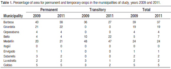
To quantify emissions from the use of organic and synthetic fertilizers, lime and urea application to soils in the Aburrá Valley, information from areas in permanent and temporary crops recorded in Antioquia Statistical Yearbooks for 2009 (Gobernación de Antioquia, 2010) and 2011 (Gobernación de Antioquia, 2012) was used for each category of crops in the region. The percentage contribution from each municipality to the total area of permanent and temporary crops are shown in Table 1.
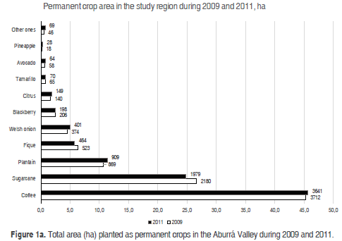
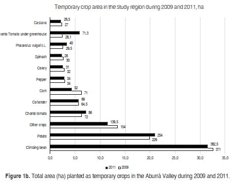
The area planted as specific permanent crops in the two years of study at the Aburrá Valley is shown in Figure 1a, while the corresponding area of temporary crops is shown in Figure 1b. A total of nineteen different crops were included within the category of permanent crops, while another twenty were classified as temporary crops.
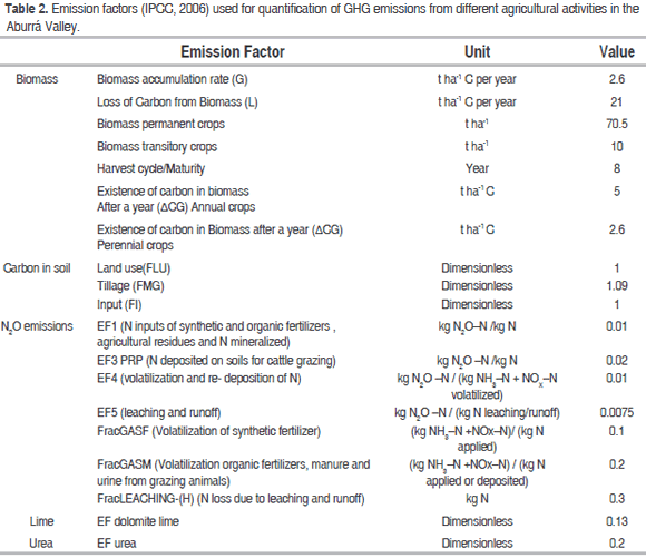
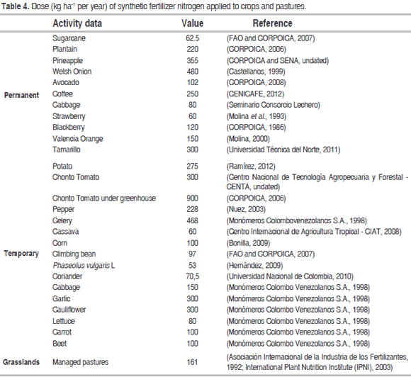
The contributions of urea were also included in managed pastures, which were estimated to be 13,738 ha in 2009 and 12,224 ha in 2011. Being a TIER 1 inventory, the emission factors used were those supplied by default in the IPCC Guidelines (IPCC, 2006), and those are presented in Table 2.
After evaluating the reliability of the information, this was inputted in both the IPCC software (WMO, UNEP, IPCC, SPIRIT, 2013), as in the worksheets developed based on the IPCC guidelines (IPCC, 2006), with the aim of having supports in the verification of results.
Uncertainty estimation
The uncertainty estimate constitutes good practice and it is an essential element in an exhaustive inventory of emissions and removal of gases. In this study, the uncertainty analysis was carried out by the method of error propagation, which is based on measuring the propagation of uncertainty in emissions or removals based on combining the uncertainties in activity data, emission factors and other estimation parameters using the following equation:

Where Utotal is the uncertainty percentage of the product of the quantities (half the 95 percent confidence interval, divided by the total and expressed as a percentage) and Ui is the uncertainty percentage associated with each of the quantities.
RESULTS AND DISCUSSION
Changes in land use and estimated soil area used for different crops
By using the information available from the "SIMAP" and "Green Belt" maps to identify crop areas in the Aburrá Valley, a total of 13,514.3 ha was obtained, for the year 2009 and 14.102 ha for 2011. It was not possible to account for the type of crops represented in these areas, only to quantify the changes in areas under permanent and temporary crops. From the second source of information used, the Statistical Yearbook of Antioquia, more detailed information was obtained on the areas for each crop by municipality (Table 3). The major permanent crops in the study area are coffee and sugarcane, with an approximate combined share of 72% of the total area of the permanent crops for 2009 and 71% for 2011 (Figure 1a). In turn, as shown in Figure 1b, the transitional cultivation with greater crop area is arbustive bean, which occupied 32.6% of the total area in 2009 and 31.5% in 2011, followed by potatoes and other seasonal crops (including beans, beets, cabbage, lettuce, carrot and onion), with minor contributions of 20 and 13.5% of the total area, respectively. The area destined for managed pastures was of 13,739 and 12,225 ha for the years 2009 and 2011, respectively.
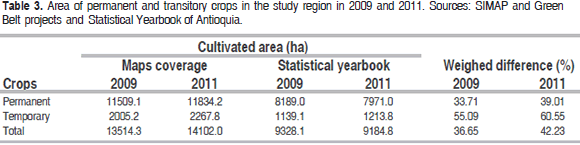
There was a difference of 4,186 ha between both sources of information (maps vs. yearbook) in 2009. For 2011, that difference was 4,917 ha. These differences depict the sum of several inaccuracies, which include those associated with the collection of data on maps and the inability to access information of detail on the differentiation of vegetation cover with greater certainty. It should be noted that statistical yearbooks are made "by consensus" in the Municipal Agricultural Technical Assistance Units (UMATA) and this would explain much of the observed discrepancy between these two estimates.
In terms of use of land for crops, the municipality with the greatest contributions to total crop area is Barbosa, which represented 39% of the total crop area in 2009 and 37% of total crop area in 2011 (Table 1). The municipality of Medellín contributes 24% of total crop area in the Aburrá Valley. This corresponds mainly to the contribution of the rural areas of San Antonio de Prado, San Sebastián de Palmitas and San Cristóbal (Alcaldía de Medellín y Universidad Nacional de Colombia, 2009).
The rate of N applied to soils was determined through review of the literature regarding crop nutrient requirements and the recommended dose of nitrogen fertilizer application, for the main permanent and temporary crops and pastures in the Aburrá Valley (Table 4).
Quantification of emissions
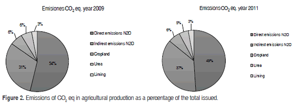
It was estimated that total emissions (Gg CO2 eq) were 63.1 in 2009 and 66.0 in 2011. These corresponded to around 30% of emissions from AFOLU in the Aburrá Valley in 2009 and 32% of AFOLU emissions in 2011. The main source of GHG emissions in agricultural activities is the application of N to the soil in the form of synthetic and organic fertilizers. Thus, direct N2O emissions corresponded to 54 and 49% of total emissions for 2009 and 2011, respectively, whereas indirect N2O emissions were 31% for 2009 and 37% by the year 2011. According to Stehfest and Bouwman (2006), the increase in atmospheric N2O concentration is primarily due to increased use of nitrogenous fertilizers in agriculture, and this is denoted in other reports in the literature. In 2008, in the module of agriculture of the GHG Inventory of Cundinamarca, Colombia, Pulido (2012) reported that 49% of contributions to GHG from agricultural land came from the use of nitrogenous fertilizers, both organic and synthetic, which is consistent with the findings in this study.
The agricultural practice that generates the lowest annual GHG emissions to the atmosphere is the application of lime, which contributed approximately 1.8 Gg CO2 eq in both years, corresponding to 3% of total emissions from agricultural activities, as shown in Figure 2. This is due both to the lower frequency of this practice as well as the low emission factor associated with this activity (Table 2).
In 2009 and 2011, the application of synthetic fertilizers produced 56% of total direct emissions of N2O in the Aburrá Valley, while the contribution of N by deposition of urine and manure in the pasture by grazing cattle, produced about 41%. Tubiello et al. (2014) reported that 2011, global emissions resulting from the application of synthetic fertilizers were about 14% of total emissions from agriculture. During the period 2001-2011, annual emissions from this activity increased by 37%. Emissions estimated in this study for the Valley of Aburrá do not differ from these estimates.
Most indirect N2O emissions, were generated by volatilization and leaching of N from manure applied to the soil as organic fertilizer or deposited directly by grazing (68% in 2009 and 76% in 2011). In extensive grazing, type of cultural practices and inadequate application of synthetic nitrogen fertilizers are major sources of emissions due to great losses of N in nitrification and denitrification (Van Der Hoek, et al., 2007; Popp et al, 2010). In addition, high rainfall accentuate leaching processes (Eckard and Cullen, 2011). Tubiello et al. (2014) reported that global annual N2O emissions from application of manure as fertilizer increased by more than 12% between 2001 and 2011, with N supply mainly coming from cattle (45%) and pigs (18%) manure; while emissions from manure and urine deposited on pastures increased by 16% over the same period.
Emissions of N2O arising from residues of beans, corn, potatoes, carrots and cassava crops contributed approximately 0.8% to total GHG emissions in this period. This small contribution can be attributed to little production of these crops in the region and the emission factor used. In this study, the contribution to emissions from the burning of crop residues, were estimated to be zero, since there are no official figures on this practice for the ten municipalities included in the study. In 2011, the global contribution of this practice was estimated to be only 0.5% of total emissions from agriculture and originated from burning corn, wheat, rice and sugarcane crop residues (Tubiello et al., 2014).
The emissions associated with land use changes were 4.13 Gg CO2 eq for both years, of which 100% was due to CO2 emissions, mainly by the passage of forest lands, pastures and stubble, to farmland as the agricultural frontier advanced (Dawson and Smith, 2007; Sierra et al, 2007). It was estimated that 689.5 ha in pasture and forestry became agricultural crops in 2009 and 2011. The IPCC (2013) suggested that logging activities disturb the carbon stored in soil and biomass, resulting in average annual net emissions of CO2 of 0.9 [0.1 to 1.7] Gt C per year over the period of 2002 to 2011. As this is a new measurement, and countries have not yet based their national communications on the 2006 IPCC guidelines, it is not possible to compare the results obtained in this study with those of previous national communications.
Uncertainty in the estimation of emissions
Several sources of uncertainty were identified, including the estimation of activity data and the appropriateness of the emission factors, which may not be applicable to the conditions of production systems evaluated (Milne et al., 2014). To verify doses of fertilizers used by producers in the area, the concept of experts and producers of major crops in the study area were included. The uncertainties of crop areas from the two sources of information were estimated as well as those originated by organic fertilizer, urea and lime application to the soils, and those derived from the use of unspecific emission factors for calculating emissions of CO2 and N2O. The combined uncertainties obtained for each category using the error propagation method are shown in Table 5.
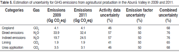
The magnitude of the uncertainties encountered was due to the difficulties in identifying reliable and detailed information sources, corresponding to the characteristics of the study of the area. Additionally, the lack of precise, updated and reliable geographic information, represented an obstacle to determine land use and its evolution over time, increasing the uncertainty of the inventory. The default emission factors used can be further sources of uncertainty, as they may not be representative of the GHG emissions associated with agricultural production at the Aburrá Valley (Flynn et al., 2005). Uncertainty can change depending on the quality of activity data and emission factors used, and according to the IPCC uncertainties of up to 100% can be qualified as acceptable for a TIER 1 inventory, yet there is not any doubt that the completeness and quality of information needs to be improved (Rypdal and Winiwarte, 2001).
CONCLUSIONS
The GHG emissions from agricultural production in the Aburrá Valley for the years 2009 and 2011 were 63.1 and 66.0 Gg CO2 eq, respectively. These emissions correspond approximately to 1.3% of total GHG emissions in the Aburrá Valley for 2009 and 2011. Nitrogen fertilization is the main source of N2O emissions in the Aburrá Valley, with a contribution of 85% in emissions in 2009 and 86% in 2011. Of these, the contribution of synthetic nitrogen and organic nitrogen fertilization by pig and poultry manure act as the main source.
The change in the use of forest and pasture soils towards crops was an important source to CO2 emissions, contributing 6% of total emissions. Despite the low emissions as a result of land use, this should be highlighted as it involves the felling of natural and planted forests, loss of high and low shrubby areas, reducing the capture of CO2 from not only in agricultural production by soil disturbance and use of lime and urea, but in other sectors such as the industry. This also means the loss of ecosystem services that forests provide, such as biodiversity, protection of water sources, control of erosion and landscape services, among others.
ACKNOWLEDGEMENTS
The authors thank the Metropolitan Area of the Aburrá Valley for their interest in improving the environmental quality and quality of life of the inhabitants of this region, by signing the Agreement 298 of 2013, which made possible the realization of this work and the First GHG Inventory for the region.
REFERENCES
Alcaldía de Medellín y Universidad Nacional de Colombia. 2009. Coberturas vegetales, uso actual del suelo y determinación de conflictos de uso del suelo con base en el POT de la zona rural del municipio de Medellín. Medellín. [ Links ]
Área Metropolitana del Valle de Aburrá. 2007. Plan de Desarrollo Metropolitano. METROPOLI 2008-2020. Hacia la integración regional sostenible. Medellín. [ Links ]
Área Metropolitana del Valle de Aburrá. 2010. Atlas Área Metropolitana del Valle de Aburrá. Medellín. [ Links ]
Asociación Internacional de la industria de los fertilizantes - IFA, Organización de las Naciones Unidas para la Agricultura y la Alimentación - FAO. 2004. Estimaciones globales de emisiones gaseosas de NH3, NO y N2O provenientes de tierras agrícolas. FAO, Roma. [ Links ]
Asociación Internacional de la Industria de los Fertilizantes. 1992. IFA. Recuperado el 25 de Octubre de 2013, de http://www.fertilizer.org/ifa/HomePage/LIBRARY/Our-selection2/World-Fertilizer-Use-Manual/by-type-of-crops [ Links ]
Bonilla, N. (comp.) 2009. Manual de recomendaciones técnicas: cultivo de maíz (Zea mays). Instituto Nacional de Innovación y Transferencia en Tecnología Agropecuaria, INTA, San José, Costa Rica. 72 p. [ Links ]
Castellanos, P. 1999. Manejo integrado del cultivo de cebolla de rama Allium fistulosum L. para el departamento de Risaralda. Universidad de Caldas. Pereira. pp. 9-10. [ Links ]
CENICAFE. 2012. Alternativas generales de fertilización para cafetales en la etapa de producción. Avances Técnicos CENICAFE (424): 1-8. [ Links ]
Centro Internacional de Agricultura Tropical - CIAT. 2008. Fertilización del cultivo de la yuca. CIAT, Cali. 65 p. [ Links ]
Centro Nacional de Tecnología Agropecuaria y Forestal - CENTA. Undated. Guía técnica cultivo de tomate. CENTA, El Salvador. 48 p. [ Links ]
CORPOICA. 1986. Proyecto de transferencia de tecnología sobre el cultivo de la mora. [ Links ]
CORPOICA. 2006. El cultivo de tomate bajo invernadero. CORPOICA, Rionegro, Antioquia. [ Links ]
CORPOICA. 2006. Manejo sostenible del cultivo del Plátano. : CORPOICA, Bucaramanga. [ Links ]
CORPOICA. 2008. Tecnología para el cultivo del Aguacate. CORPOICA Rionegro, Antioquia. [ Links ]
CORPOICA y SENA. Undated. Curso de actualización en el cultivo de la Piña. CORPOICA. [ Links ]
DANE. 2007. DANE. Recuperado el 02 de Septiembre de 2014, de https://www.dane.gov.co/index.php/es [ Links ]
Dawson, J. and P. Smith. 2007. Carbon losses from soil and its consequences for land-use management. Science of the Total Environment 382: 165-190. doi: 10.1016/j.scitotenv.2007.03.023 [ Links ]
Echeverri, C. 2006. Estimación de la emisión de gases de efecto invernadero en el municipio de Montería (Córdoba, Colombia). Revista Ingeniería Universidad de Medellín, 5(9): 85-96. [ Links ]
Eckard, R. and B. Cullen. 2011. Impacts of future climate scenarios on nitrous oxide emissions from pasture based dairy systems in southeastern Australia. Animal Feed Science and Technology, 166-167, 736-748. doi: 10.1016/j.anifeedsci.2011.04.052 [ Links ]
FAO and CORPOICA. 2007. Buenas prácticas en la producción de fríjol voluble. Medellín. [ Links ]
FAO and CORPOICA. 2007. Manual técnico. Buenas prácticas agrícolas (BPA) y buenas prácticas de manufactura (BPM) en la producción de caña y panela. CORPOICA, Rionegro, Antioquia. [ Links ]
Flynn, H., J. Smith, K. Smith, J. Wright, P. Smith and J. Massheder. 2005. Climate- and crop-responsive emission factors significantly alter estimates of current and future nitrous oxide emissions from fertilizer use. Global Change Biology, 11(9): 1522-1536. doi: 10.1111/j.1365-2486.2005.00998.x [ Links ]
Gobernación de Antioquia. 2010. Anuario Estadístico de Antioquia, 2009 [Recurso electrónico]. Medellín, Antioquia, Colombia. [ Links ]
Gobernación de Antioquia. 2012. Anuario Estadístico de Antioquia, 2011 [Recurso electrónico]. Medellín, Antioquia, Colombia: Departamento Administrativo de Planeación. [ Links ]
Grupo de Investigaciones Ambientales - GIA. 2014. MODEMED. Recuperado el 02 de Septiembre de 2014, de http://modemed.upb.edu.co/zigma2/index.php?option=com_contentandview=articleandid=121andItemid=553 [ Links ]
Hernández, J. 2009. Manual de recomendaciones técnicas: cultivo de frijol (Phaseolus vulgaris). Instituto Nacional de Innovación y Transferencia en Tecnología Agropecuaria, INTA, San José, Costa Rica. 72 p. [ Links ]
IDEAM. 2009. Segunda comunicación nacional ante la Convención Marco de las Naciones Unidas sobre Cambio Climático. Bogotá D.C. [ Links ]
Instituto Nacional de Ecología, Secretaría de Medio Ambiente y Recursos Naturales. 2004. Inventario Nacional de gases de efecto invernadero 1990-2002. México D.F. [ Links ]
International Plant Nutrition Institute - IPNI. 2003. Manual de nutrición y fertilización de pastos. Quito. [ Links ]
IPCC. 2006. 2006 Guidelines for national greenhouse gas inventories, prepared by the National Greenhouse Gas Inventories Programme, Eggleston H.S., Buendia L., Miwa K., Ngara T., and Tanabe K., (eds). Published: IGES, Japan. [ Links ]
IPCC. 2008. Cambio climático 2007. Informe de sintésis. Contribución de los grupos de trabajo I, II, y II al cuarto informe de evaluación del Grupo Intergubernamental de Expertos sobre el Cambio Climático. IPCC. Ginebra, Suiza: [ Links ]
IPCC. 2013. Cambio Climático Bases Físicas. Contribución del Grupo de trabajo I al Quinto Informe de Evaluación del IPCC. Resumen para responsables de políticas. Grupo Intergubernamental de Expertos sobre el Cambio Climático. Suiza. [ Links ]
Milne, A. E., M. J. Glendining, P. Bellamy, T. Misselbrook, S. Gilhespy, M. R. Casado and A.P. Whitmore. 2014. Analysis of uncertainties in the estimates of nitrous oxide and methane emissions in the UK's greenhouse gas inventory for agriculture. Atmospheric Environment, 82: 94-105. doi: 10.1016/j.atmosenv.2013.10.012 [ Links ]
Molina, E. 2000. Nutrición y fertilización de la naranja. Informaciones Agronómicas, 40: 5-11. [ Links ]
Molina, E., R. Salas and A. Castro. 1993. Growth curve and nutrients absorption in strawberries (Fragaria x ananassa cv. Chandler). Agronomía Costarricense, 17: 67-73. [ Links ]
Monómeros Colombo Venezolanos S.A. 1998. Fertilización de cultivos de clima frío. Saenz y Cia Ltda, Bogotá [ Links ].
Naciones Unidas. 1992. Convención Marco de las Naciones Unidas sobre el Cambio Climático. 26 p. [ Links ]
Nuez, F.G. 2003. El cultivo de pimientos, chiles y ajíes. Mundi Prensa, Madrid. 586 p. [ Links ]
Popp, A., H. Lotze-Campen and B. Bodirsky. 2010. Food consumption, diet shifts and associated non-CO2 greenhouse gases from agricultural production. Global Environmental Change 20: 451-462. doi: 10.1016/j.gloenvcha.2010.02.001 [ Links ]
Pulido, A. 2012. Inventario de emisiones de gases de efecto invernadero para la región Cundinamarca-Bogotá. Tesis Maestría. Universidad Nacional de Colombia, Bogotá [ Links ].
Ramírez, F. 2012. En Antioquia Fertilización a la carta. Revista PAPA, Federación Colombiana de Productores de papa. No. 20: 26-29. [ Links ]
Rypdal, K. and W. Winiwarte. 2001. Uncertanties in greenhouse gas emission inventories - evaluation, comparability and implications. Environmental Science and Policy, 4: 107-116. doi: 10.1016/s1462-9011(00)00113-1 [ Links ]
Secretaria de Ambiente y Desarrollo Sustentable. 2007. Segunda Comunicación Nacional de la República de Argentina a la Convención Marco de las Naciones Unidas sobre Cambio Climático. Buenos Aires. [ Links ]
Seminario Consorcio Lechero. Undated. Consorcio Lechero La Cadena láctea de Chile. Recuperado el 29 de Julio de 2013, de http://www.consorciolechero.cl/chile/docs/brassicas-forrajeras.pdf [ Links ]
Sierra, C., J. del Valle, S. Orrego, F. Moreno, M. Harmon, M. Zapata, J. Benjumea. 2007. Total carbon stocks in a tropical forest landscape of the Porce region, Colombia. Forest Ecology and Management, 243: 299-309. doi: 10.1016/j.foreco.2007.03.026 [ Links ]
SIMAP. 2007-2012. Sistema metropolitano de áreas protegidas y el proyecto de cinturón verde. [ Links ]
Stehfest, E. and L. Bouwman. 2006. N2O and NO emission from agricultural fields and soils under natural vegetation: summarizing available measurement data and modeling of global annual emissions. Nutrient Cycling in Agroecosystems, 74(3): 207-228. doi: 10.1007/s10705-006-9000-7 [ Links ]
Tubiello, F., M. Salvatore, R. Cóndor, A. Ferrara, S. Rossi, R. Biancalani, A. Flammini. 2014. Agriculture, forestry and other land use emissions by sources and removals by sinks. 1990-2011 Analysis. FAO Statistics Division. Working Paper Series ESS/14-02. [ Links ]
Universidad Nacional de Colombia. 2010. Determinación de los requerimientos hídricos del cilantro. Palmira. [ Links ]
Universidad Técnica del Norte. 2011. Efecto de la aplicación de silicio en el segundo año de producción en el cultivo del tomate de árbol. Ecuador. [ Links ]
Van Der Hoek, K., M. Van Schijndel and P. Kuikman. 2007. Direct and indirect nitrous oxide emissions from agricultural soils, 1990 - 2003. Background document on the calculation method. RIVM, Netherlands. [ Links ]
WMO, UNEP, IPCC, SPIRIT. 2013. IPCC Inventory software versión 2.11.5029.17605. 2006 IPCC Guidelines. Tokyo, Japan. [ Links ]
Working Group II, IPCC. 2014. Climate change 2014: mitigation of climate change. IPCC. Cambridge University Press, 1465 p. [ Links ]
