


 Inglês (pdf)
 Artigo em XML
 Referências do artigo
 Enviar este artigo por email
 Citado por SciELO
  Citado por Google
  Similares em
SciELO
Similares em
SciELO  Similares em Google
 Permalink
Irrigation is considered a fundamental element in agriculture due to its effect on increasing production, improving the quality of products, sustainable intensification of land use and its contribution to safety food (FAO, 2000; 2011). In 2012, there were more than 324 million hectares in the world equipped for irrigation, of which approximately 85% or 275 million are effectively irrigated; by 2010, China became the country with the largest area of irrigation, and together with India, it covers 42% of the world's irrigation (AQUASTAT-FAO, 2014). In this way, irrigation has reduced the dependence on seasonal agriculture, thus achieving high agricultural production (Rhoades et al., 1992). In soils such as those in semi-arid regions where water requirements for crops are high and are necessarily supplied by irrigation districts, the use of these causes serious problems of environmental degradation that hampers the growth of crops and regional production in general (Abbas et al., 2013). Although irrigation districts bring advantages to agricultural systems, they have also brought with them environmental problems, such as: Salinization of soils, contamination of surface and groundwater bodies, changes in the landscape, and stress on plants.
The mobilization of salts in the soil is very variable among the different irrigation zones and according to Chedlia et al. (2012). Salinity depends on several factors such as the amount of salts present in the water, the texture of the soil, the distance from the intake to the district, the hydrogeology of the area, irrigation and drainage, and climatic conditions (rainfall regime, average temperature) (Duncan et al., 2008). For Girón-Ríos et al. (2009), salinity is a complex process of chemical degradation, which influences significant changes in the physical properties of soils and is affected mainly by the presence of salts in irrigation water and efficiency of the same (Aragüés et al., 2011).
Colombia has not been unrelated to the problem of salinization, in the different soil studies conducted, it is common to find that the soils have degradation phenomena, with erosion and salinization being the main problems in the territory. In this regard, the country ratified the United Nations Convention to Combat Desertification and Drought (UNCCD), which considers as an important strategy the identification and monitoring of soil degradation processes at the national, regional and local levels (FAO, 2000; 2011). Currently, public institutions of national order have been making important efforts to diagnose salinity problems in the country's soils, such as the national map of soil degradation by salinization carried out by IDEAM in 2017.According to this study, 14,041,883 ha (12.3%) of the country's soils (continental and insular areas) present some degree of degradation due to salinization. The very severe and severe degradation occupies 2,726,757 ha (2.4%); the moderate degree 8,885,369 ha (7.8%) and with 2,449,757 ha slightly (2.1%).
In Boyacá, the most important agricultural production unit in the department and the largest sprinkler irrigation district that has been built in a cold climate zone, is the DRACH, which has eleven irrigation units (Pacheco et al., 2004) and covers an area of 8016.78 ha. The problem of salinization has been recognized as a limiting factor in the agricultural soils that currently correspond to DRACH since 1960, the Colombian Institute for Agrarian Reform - INCORA (by its initial in Spanish), carried out drainage works to enable land to agriculture. The soils of the Tundama - Suamox valley are very vulnerable to salinization due to the natural conditions and the management that has been given to the upper basin of the Chicamocha River. For 2012 after an extreme rainfall weather event where 3000 ha were affected, the main victims were the agricultural producers who benefit from the DRACH and both urban and rural inhabitants of the municipalities of Paipa, Duitama, Nobsa, Sogamoso and to a greater extent Tibasosa (GISSAT, 2012), after this extreme weather event the problem of salinization was evidenced, where high electrical conductivities and saline scabs were observed. Therefore, with this research we sought to determine which were the most predominant soluble salts in the soils that comprise the DRACH and its special distribution.
MATERIALS AND METHODS
Location
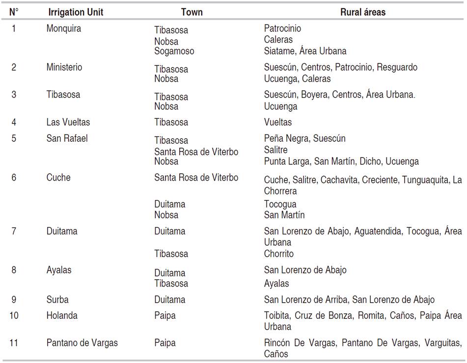
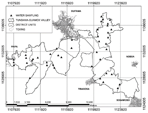
The research was conducted in the DRACH which covers the towns of Paipa, Duitama, Tibasosa, Santa Rosa de Viterbo, Sogamoso and Nobsa (Figure 1) over the eleven irrigation units (Table 1).
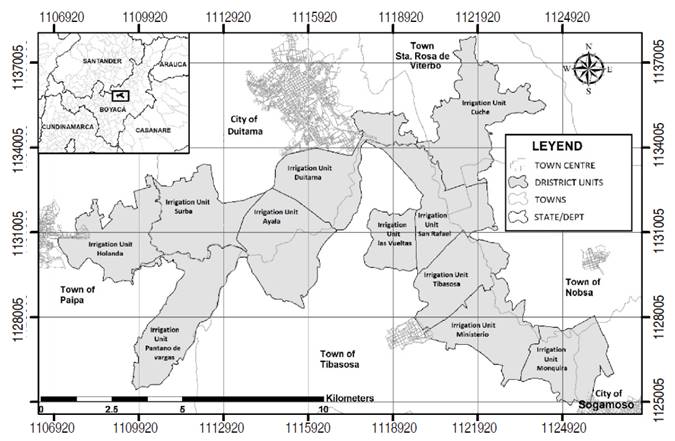
The DRACHis located in the department of Boyacá, approximately 180 km from Bogotá, with an average temperature of 14 °C, with an average rainfall of 778 mm, an average altitude of 2560 m and a relative humidity of 70% (Martínez et al., 2008). Most of the soils are of agricultural vocation, however, dairy cattle stands out and, on a smaller scale, dual-purpose cattle (GISSAT, 2012).
In the DRACH data were taken for soils and waters which were georeferenced and projected to the Magna Colombia Bogotá coordinate system. The samples were faced in the dry period, after the La Niña phenomenon (2010-2012).
Soils analysis for Salinity
Based on the chemical soil analysis information from 301 samples, obtained from studies conducted by the Interinstitutional Research Group on Tropical Acid Sulphate Soils (GISSAT-UPTC, 2012) and Corpoica; electrical conductivity (E.C) by saturation extract - conductivity meter, hydrogen potencial (pH) by the 1:1 ratio method and the soluble salts in the soil were determined, for this the cations were obtained by atomic absorption.
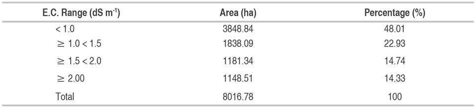
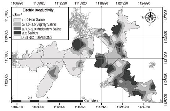
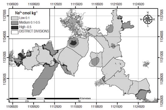
To establish the spatial tendency of salinity, the geostatistical analysis of the E.C, pH, Sulfates (SO4 =), Sodium (Na2+), was carried out. For the spatial analysis of the variables studied, the Geostatistical analyst tool of the ArcGis 10.3 software was used, the interpolation method used was ordinary Kriging. To classify the salinity of DRACH soils, the following ranges of electrical conductivity (E.C.) were used: saline (≥ 2 dS m-1), moderately saline (≥ 1.5 < 2 dS m-1), slightly saline (≥ 1 < 1.5 dS m-1) and not saline (< 1 dS m-1), according to Castro and Gómez (2010). Regarding the classification used for sulfates (SO4 =), the following ranges were used: Under 11 ppm, Optimum 38 ppm and High 64 ppm according to Castro and Gómez (2010). For sodium, the ranges were used: low 0.1 cmol kg-1, medium 0.1-0.5 cmol kg-1 and high > 0.5 cmol kg-1 according to Castro and Gómez (2010).
Groundwater analysis for Salinity
Thirty-one water samples were collected wells of the phreatimetric network to perform the chemical characterization corresponding to pH with potentiometer, E.C with conductivimeter, sulfates by colorimetry, and by titulation were obtained the chlorids, carbonates, Bicarbonates and nitrates, the cationes (Na2+, Ca2+, Mg2+ and K) by atomic absorption. This information allowed to determine the quality of these waters and their possible relationship with the salinization processes. The samples were analyzed in the soil and water laboratory of the Faculty of agricultural sciences of the UPTC (by its initials in Spanish), with the analytical methodology (Analytical Control Soil Laboratory- ICONTEC).
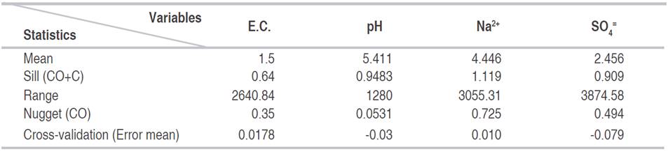
The research had a non-experimental design, since independent variables could not be manipulated, where the phenomenon of salinization was observed in its natural context within the irrigation District. For each of the variables, the basic descriptive statistics were calculated, in which the mean, median, kurtosis and asymmetry were calculated, as well as the parameters of the semivariogram (Sill, Nugget and Range) and the cross validation (Table 2).
RESULTS AND DISCUSSION
As it is mentioned by Narváez et al. (2014), classical statistics and geostatistics are some of the tools for the analysis of soil salinity that contributes to the identification of affected areas and the monitoring of spatio-temporal variations, in the Table 2 the results for the geostatistical analysis of the variables studied are observed.
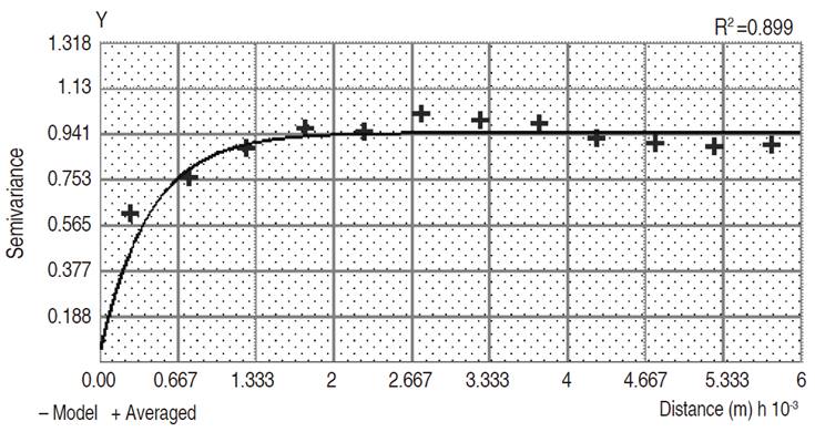
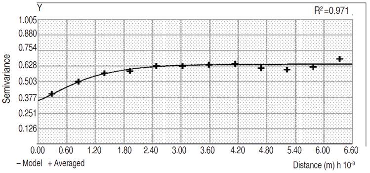
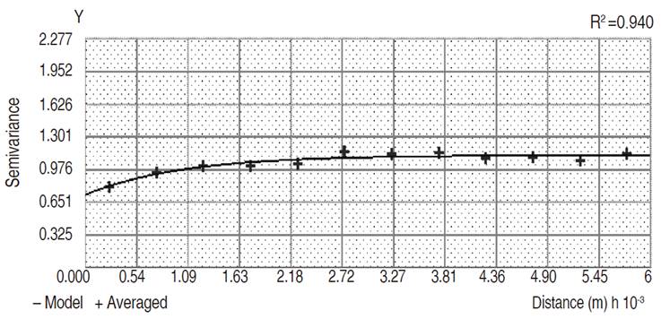
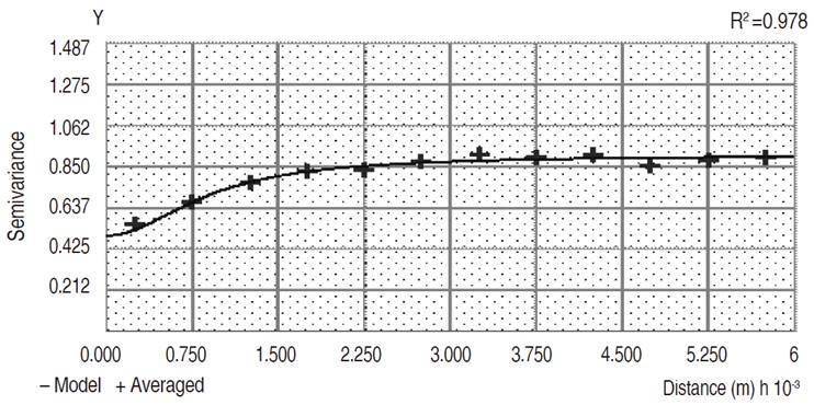
The statistical model that was best adjusted for the variables pH (Figure 2), E.C (Figure 3), Na2+ (Figure 4) was the exponential, while for the sulfates was the Rational Quadratic model (Figure 5). These variables were studied because they are the most representative soluble salts of the zone.
According to the Kolmogorov-Smirnov normality test, the variables analyzed show a non-normal behavior except for pH (Table 2). For Cressie (1993), normality is not a mandatory requirement for the analysis of geostatistical data, however, it must be considered that the distribution of the data don´t show a very long tail, since it compromises the results for the Kriging estimates.
Variability is an intrinsic characteristic of each property and its specific behavior for each soil condition, use and management; therefore, interpreting the autocorrelation of a variable along its distribution in one area, and its correlation with respect to another variable or variables, is a study that has a large number of immersion factors, and requires clear knowledge of the factors that condition it (Jaramillo et al., 2008). The Range is the zone of influence and corresponds to the distance from which two observations are independent (Giraldo, 2002). All the variables had a moderate spatial dependence (Table 2) according to the classification proposed by Cambardella et al. (1994), since the relationship between the plateau and the nugget effect [C/(Co+C)] is between 0.25 and 0.75, the pH showed a range of 1287.93 m, the E.C a range of 2048.9 m, Na2+ a range of 3055.31 and the SO4 = a range of 3874.58, indicating that there is a spatial correlation in each of the variables at that distance.
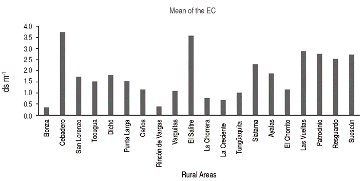
The results of the descriptive analysis for the soil variables showed that the E.C. of the soil saturation extract, presented an average value of 1.77 dS m-1; the highest value was registered in the town of Santa Rosa rural area “El Salitre” with an E.C. of 6.57 dS m-1 and the lowest in the municipality of Paipa with 0.16 dS m-1. Figure 6 shows the behavior of the mean of the E.C. values for the districts that make up the district.
It should be noted that 48.01% of the district's soils are found in the range of E.C. < 1 dS m-1, which classifies it as non-saline (Table 3), 22.93% between ≥ 1.0 < 1.5 dS m-1 which is classified as slightly saline, 14.74% between ≥ 1.5 < 2 dS m-1 which are moderately saline and 14.33% have values higher than ≥ 2 dS m-1 are saline soils (Figure 7), which indicates that they are soils that begin to have salt problems, according to Castro and Gómez (2010). These values coincide with those reported by Mercado et al. (2011) who in the Doctrina Irrigation District, Colombia found values higher than 3 dS m-1, which indicated salinity problems for those areas. The electrical conductivity of the soil is a function of the clay content and water content (Kurtulus et al., 2009, Narváez et al., 2014), with the topography, and the phreatic level which allows high variability to be present for this parameter (Ulset et al., 1998).
The pH presented an average value of 5.52. In general, it was between the range of 5-6 that corresponds to moderately acid soils, with 46.64% of the total area of the district (Figure 8). The Resguardo area had a mean value of 7.28, that may be associated with the presence of salts such as sodium chloride (NaCl2) (Mercado et al., 2011).

For the cations, it was evidenced that the element with the greatest presence in DRACH soils was sodium, followed by Ca in less quantity. Considering the ranges provided by Castro and Gómez (2010), for Na greater than 0.5 cmol kg-1 and for Ca higher than 6 cmol kg-1, there is a high grade of salinization due to very high concentration levels. In Figure 9, the behavior of Na within the district is observed, 73.93% of the soils have low concentrations with levels of 0.1 cmol kg-1, 21.49% are in the middle range with values between 0.1-0.5 cmol kg-1 and 4.57% have high levels with values greater than 0.5 cmol kg-1. High values were found in the Salitre area with 4.29 cmol kg-1, followed by El Cebadero with 4.085 cmol kg-1 that may be related to the saline deposits (Na2SO4 and NaCl2), which are of the characteristics of the thermal sources of Paipa (Moreno and Fechi, 2006). Taiz et al. (2006), mention that the Na concentration of a sodium soil can not only directly damage the plants, but also degrade the structure of the soil, reducing the porosity and being a highly hygroscopic element, it traps the water molecules of the soil, which causes the water of hydration to decrease for other nutrients, also affecting the structure of the soil by breaking up its particles (Madueño et al., 2006). Besides that the hydrolysis of the sodium clays, leads to the alkalinization of the profile, and these cause an intense mineral alteration (Mata et al., 2014). While if Ca2+ and soluble salts are very abundant in the soil, it is likely that the profile is very poorly differentiated, but its structure tends to be stable, as a result of the flocculating action of Ca2+ so the high osmotic pressure of the soil solution is responsible for low productivity (Mata et al., 2014).
Ca2+ reported high values in the Salitre rural zone with 42.01 cmol kg-1, followed by las Vueltas with 30 cmol kg-1 while the lowest values were found in the village of Rincon de Vargas with 4.236 cmol kg-1. Mercado et al. (2011) obtained Ca values higher than 6 cmol kg-1 in an average of 89.5% of the total area studied.
The sulphates (SO4=) were the dominant anions, mainly due to their high solubility, the area of Cebadero presented an average of 93.298 mg kg-1 being the highest value, followed by the area of Salitre with 54.238 mg kg-1; they are high values considering the ranges established by Castro and Gómez (2010). In Figure 10, the behavior of the sulphates in the district is observed, 48.90% of the area is at a low level (11 ppm), 48.86% of the area presents an optimum range with 38 ppm and the 0.30% of the district presents problems due to high levels (64 ppm).
For chlorides (Cl-) the rural area el Resguardo reported the value of the highest average with 42.80 mg kg-1 followed by Siatame in Sogamoso with 30.76 mg kg-1 the behavior of these is noted in Table 3. These latter are at a low level according to Castro and Gómez (2010), where the high ranges are 142 mg kg-1 and above. Qadir et al. (2007) state that the predominant soluble salts in saline soils are sulfates, chlorides, bicarbonates of Na2+, Ca+2 and Mg+2. Na is the cation that most binds to sulfates and chlorides to form salts, with less frequency found potassium and bicarbonates, carbonates and nitrates (Dorronsoro, 2011; Ramírez, 2011).
Fernández et al. (2007) indicate that the high variability of the parameters mentioned above may be due to the fact that soil properties such as interchangeable cations, sulphates and others not related to soil morphology are affected by the use and / or management. Similarly, Narváez et al. (2014) indicate that in saline soils, the depth of the water table, the evapotranspiration rate, and other geohydrological factors impact on the chemical properties, resulting also in a high spatial and temporal variability of the same. According to this, the high variability obtained for the parameters is generated by the interaction of the different properties of the soil with its immediate environment, this means, agricultural practices, variations in climate among others, agricultural practices, variations in climate among others, cause changes at different scales (Mallarino and Wittry, 2004).
For the waters, it was found that the water tables oscillated between 0.54 and 2.99 m in the irrigation units San Rafael in Nobsa and Cuche in Santa Rosa de Viterbo; these values coincide with those reported by Castro and Gómez (2015) who argue that in the dry season about 30% of the area, the reading and analysis levels of the District's aeration profile zone are between 0.0 and 1.0 m, while in the critical rainy season there is a rise in the water table, reaching times of flooding, which can affect up to 45% of the area. It is worth noting that the waters are frequented by sales of soluble, the upper basins of the Chicamocha River have geological units composed of a very important lithological record, mostly composed of sedimentary rocks with some outcrops of igneous rocks in the Paipa and Iza surroundings (Moreno and Fechi, 2006). The phreatic mantles are found on calcareous materials can cause salinization, if these are located in climates, they are characterized by values of evapotranspiration superior to those of precipitation, the phreatic levels can ascend by the capillarity to the surface of the soils (IGAC, 2012).
Water quality analysis for irrigation was carried out in 31 wells (Figure 11). According to the classification of waters by to the Riverside standards (US Salinity Laboratory - USLS), all of them have problems of salinity and sodium (Olías et al., 2005). The average value of the E.C was 3.12 dS m-1, for pH was 6.34. In this regard, Taiz et al. (2006) mention that the higher the concentration of salts in water, the greater the electric conductivity and the lower the osmotic potential (the higher the osmotic pressure). The above allows to relate the E.C. of the soil with the water used for irrigation, in some units such as Ministry where E.C of 4.29 dS m-1 was observed in the soil and 9.79 dS m-1 in the water; in Cuche with 4.66 dS m-1 in water and 5.64 dS m-1 in soil, and finally in the irrigation unit of Vueltas with 8.54 dS m-1 in water and 2.6 dS m-1 on soil, indicating that water used for irrigation may be contributing to the salinization of soils in the district.
According to investigations by Alfaro and Ingeominas (2010), in Paipa springs there are problems with sulphated waters, as well as high concentrations of Na2+, K, Ca+2, Mg+2, Cl-1, SO4 =, HCO3. For Porras (2010), in the present thermal manifestations, alkaline-chlorinated waters appear, probably these are related to deep hydraulic circuits (reservoir), sulphate-alkaline waters that owe their origin to the addition of alkaline sulphates to the preceding waters, the area is characterized by the predominance of essentially Cretaceous and Tertiary sedimentary rocks, and the presence of possible volcanic necks with an approximate age of 2.5 million years, in addition there are thermal manifestations of high temperature, probably due to the presence of an acidic magmatic intrusion, located at a depth of 5 km. There is possible a presence of two thermal aquifers in granular and silicic sedimentary rocks with predominant secondary permeability is highlighted, in addition, the Honda or Río Salitre stream carries a high quantity of salts, supplied by the thermal springs that appear in the middle and lower area of the sub-basin (POT Paipa, 2012). Moreno and Fechi (2006), affirm that the presence of thermomineral waters in the Paipa sector are affecting the DRACH soil, due to the fact that at present they are drained to a great extent to the Vargas canal, generating: disaggregation of soil particles caused by sodium sulphates, ionic contamination by chlorine and sodium, mainly due to inadequate handling of thermal or sulfuric waters (IGAC, 2012).
CONCLUSIONS
The main soluble salt present in the soil was sodium sulphate (Na2SO4), followed by calcium sulfate (Ca2SO4), sodium chloride (NaCl2) and calcium chloride (CaCl2), which are highly soluble and toxic for the plants.
It was found that the areas with the highest problem of salinization are in Tibasosa in Patrocinio, Ucaca, Las Vueltas zones; in Santa Rosa de Viterbo in the Salitre zone and finally in Duitama in Cebadero and Higueras zones, as they have electrical conductivities greater than 2 dS m-1.
The groundwater of the sector plays an important role in the dynamics of salinization of the DRACH, due to the connection with the upper basin of the Chicamocha River, which presents geological units composed of a very important lithological record.
The presence of the Paipa springs with sulfated water problems and high concentrations of cations and anions strongly influence the salinization of DRACH soils.

