


 English (pdf)
 Article in xml format
 Article references
 Send this article by e-mail
 Cited by SciELO
  Cited by Google
  Similars in
SciELO
Similars in
SciELO  Similars in Google
 Permalink
Basin hydrological and morphometric parameters constitute a set of elements made, for planning, exploration, and management (Lux, 2012). These elements and parameters must be made on a map with sufficient hydrographic and topographic information, which has been facilitated by satellite images and Geographic Information Systems (GIS), therefore, it is no longer necessary to compute the indices in spreadsheets. Information collection in situ has been limited by public order problems in the region. Among basin morphometric indices, is the circularity index, which so far has not been calculated for the basins in the region under study.
In Brazil, a hydrographic basin is considered a territorial unit of reference and intervention, since it has a good part of the cause and effect relationships that involve the local reality, and there must be an integration of the local basic sanitation policies, uses, occupation, and soil and environment conservation with water resources policies (Lei, No. 9.433, 1997). Colombia has had extensive regulations on the management of hydrographic basins in recent decades, in which technicality predominates, but the social and conservation dimension has not been consolidated for different reasons, mainly due to violence (Bermúdez, 2014).
The hydrographic or hydrological basin is the area that collects or captures naturally water from rainfall, in which there is a convergence of a set of interrelated flow channels to a single outlet, called water intake. The water amount that reaches the river courses depends on the area size occupied by the basin, the total rainfall, and its regime, and on the losses due to evapotranspiration and infiltration (Silveira, 2001).
The automatic delimitation of hydrographic basins has become a constant study. This delimitation, made from GIS, has enabled several results that can be used in the basins study and management due to the effectiveness in data processing, ease, and low cost, since it can be performed, even, in free GIS; also, images and databases increasing availability such as SRTM (Shuttle Radar Topography Mission) images, has provided support in the basins physiographic characterization process (Cordeiro et al., 2014).
In Colombia, there are some works using SRTM images. Correa (2012) developed a method to delimit, characterize and represent cartographically terrain shapes in mountain zones in the department of Cauca, using SRTM and ASTER images. Grande (2015) used SRTM and Landsat TM 5, 7, and 8 images to develop multitemporal analysis and morphometric modeling (contour lines generation, drainage network, accumulation flows, drainage network direction), from the Molino River sub-basin in the municipality of Popayán, Cauca. Castañeda (2016), with SRTM and ASTER images, developed a semi-automated methodology, using object-based image interpretation for the terrain shapes classification and surface relief types in the municipalities of Tenjo and Tabio in the department of Cundinamarca. With Landsat images, WorldView2, and an SRTM topographic map, Cifuentes (2016) identified changes in the coastline and the climate change effects of increasing sea levels in the Buenaventura District. López et al. (2005), compared the information obtained on the ground through the geological study of outcrops in Valle del Cauca with that obtained through SRTM images, aerial photographs, and Landsat images, concluding that the tilting and bulging of the land, counterscarps, flexure scarps, and terraces, reveal the activity of partially or totally covered folds generated by the growth of reverse faults that cut increasingly older sediments towards the orogen and increasingly younger sediments towards the alluvial Cauca river valley.
A basin morphometric characterization has numerous applications, such as hydrological processes modeling, pollutants transport and deposition, and floods prediction (Moura, 2013). Studying physical aspects through morphometric analysis is possible to determine which points of the hydrographic basin are more likely to receive greater and lesser water loads (Freire and Monteiro, 2015). To evaluate the basin morphometric characteristics, the drainage density (Dd) and the circularity index (Ci) can be calculated from the basin's areas, perimeters, and drainage network.
Drainage density indicates the effectiveness of the drainage from the basin. It can vary from 0.50 km km-2 in basins with poor drainage to 3.50 km km-2 or more in well-drained basins. The higher the index, the lower the capacity to infiltrate water; low values indicate that the region is more favorable to surface infiltration and percolation that contributes to the water table (Villela and Mattos, 1975). This variable is directly related to the climatic processes operating in the studied area, which influence the dendritic material supply and transport or indicate the anthropic manipulation degree.
For the same climate type, the drainage density depends on the rock's hydrological behavior. Thus, in the most impermeable rocks, the conditions for surface runoff are better, enabling channel formation, consequently, increasing the drainage density. The opposite happens with coarse-grained rocks. The drainage density can be classified as low when it is less than 1.50; moderate between 1.50 and 2.25 and high when it is greater than 2.25 (Horton, 1945).
The circularity index tends to unity when the basin approaches the circular shape and decreases when the shape becomes elongated (Tonello, 2005). This index represents the relationship between the basin total area and a circle area of the equal perimeter to the basin total area, which, in areal expansion, is better related to river runoff. Thus, Circularity Index between 0.45 and 0.55 represents a runoff moderate level, not contributing to the water concentration that allows rapid flooding. Values greater than 0.55 indicate that the basin tends to be more circular, favoring flooding processes (fast floods). Values smaller than 0.45 suggest that the basin tends to be more elongated, favoring the runoff process (Müller, 1953; Schumm, 1956).
This work aimed to establish a methodology for the use of the SRTM digital elevation model in the automatic delimitation and morphometric analysis of basins and sub-basins in the jurisdiction of Cornare, Antioquia, Colombia.
MATERIALS AND METHODS
The digital elevation model SRTM was used, which after being processed gave rise to the hydrologically consistent digital elevation model, from which were derived the declivity map, the drainage network, and the hydrographic basins and sub-basins of the jurisdiction of Cornare, Antioquia, Colombia. Also were calculated the morphometric indices drainage density and circularity index.
The Corporación Autónoma Regional de las Cuencas de los Ríos Negro y Nare (Cornare) is an autonomous and independent public entity, integrated by municipalities that, by their characteristics, geographically constitute the same ecosystem or form a geopolitical, biogeographic, or hydrogeographic unit (Cornare, 2005).
Cornare, by law, has the function of managing, within its area of jurisdiction, the environment, and renewable natural resources, besides working for their sustainable development, following the policies of the Ministerio de Ambiente y Desarrollo Sostenible (Cornare, 2005).
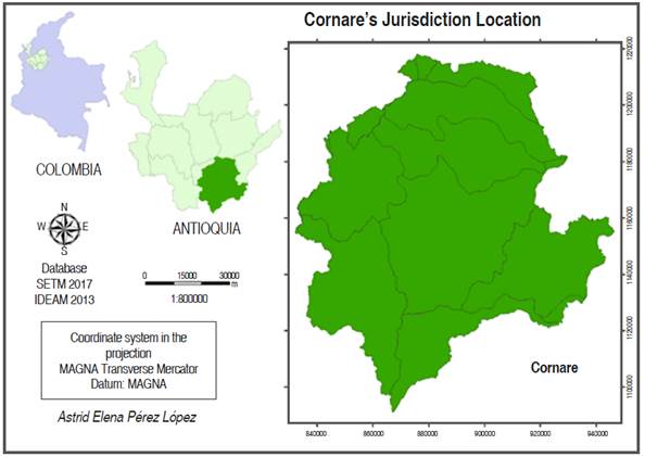
Cornare's jurisdiction is located in the East of the Department of Antioquia, extreme Northwestern of Colombia, between the geographic coordinates 5° 24' 39.77" N, 75° 34' 58.92" W and 6° 35' 11.78" N, 75° 13.58" W, with an approximate area of 8,318 km2 (Figure 1). It has high rainfall levels, with an annual average of 2,500 mm; great climatic variety, with a minimum altitude of 200 m in the Magdalena Medio plain and a maximum of 3,340 m in the hill of Las Palomas in the moor of Sonsón, which allows for areas between cold and hot (Cornare, 2005).
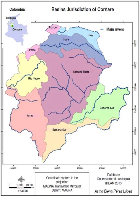
The jurisdiction is divided into eight basins, namely: Porce, Nus, Nare, Rio Negro, Arma, Samaná Norte, Samaná Sur, and Cocorná Sur (Cornare, 2005), (Figure 2).
The databases used were: Colombian Basins mapped by the Instituto de Hidrología, Meteorología y Estudios Ambientales (IDEAM) and the hydrography mapped by the Dirección de Sistemas de Información y Catastro del Departamento Administrativo de Planificación de la Gobernación de Antioquia.
The procedures in ArcGis 10.1 according to Fernandes et al. (2015) were as follows:
1. SRTM digital elevation model acquisition, 90 m resolution, on the website of Consortium for Spatial Information (CGIAR-CSI, 2017).
2. Mosaic elaboration. The study area covers two grids, so it was necessary to mosaic the digital elevation model, obtaining a single file. Then, a cutout of the digital elevation model was made using the study area as a limit.
3. Coordinate system conversion. The SRTM digital elevation model was obtained with coordinates in decimal degrees and Datum WGS84. However, to extract numerical drainage and to obtain river length measurements, and basin areas, as well as to derive the declivity map, the elevation model must be in metric coordinates. Thus, the SRTM digital elevation model was redesigned for the projection MAGNA Transverse Mercator and Datum MAGNA.
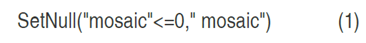
4. Elimination of systematic errors from SRTM digital elevation models. The digital elevation model presents some negative altitude values, which are characterized as noise and occur due to failures in the model's acquisition system and/or processing. The noises are usually located in regions close to water bodies and/or mountainous relief areas. In order to correct such errors is necessary to generate a hydrologically consistent digital terrain model. For this, the Raster Calculator tool was used, using equation 1. This equation makes all cells with a negative value become null (NO DATA).
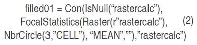
Cells with NO DATA value were filled with the mean value of the three closest cells values, considering a circle with a center in the cell to be filled. For this, the Raster Calculator tool was used, using equation 2:
5. Hydrologically consistent digital elevation model. When the spurious (erroneous) values are eliminated and the hydrograph is mapped, the watercourses must follow the correct runoff direction, going from the cell with the highest to the lowest altitude value. For this, the Fill tool was used. The model obtained is the hydrologically consistent digital elevation model. To present the digital elevation model (DEM), the Hillshade tool or shading map was used, thus emphasizing the texture, roughness, and surface relief shape characteristics. Also, from the DEM and with the Slope tool, the declivity map in degrees was generated to define the surface relief categories according to IDEAM (2013).
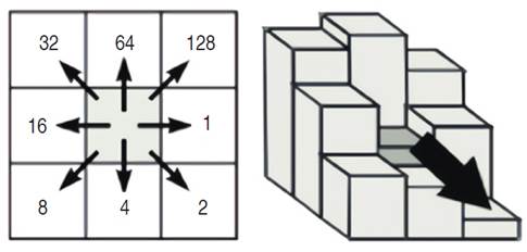
6. Hydrographic basins delimitation. The basins are delimited based on the runoff direction from the drainage network. The Flow Direction tool defines for each grid cell the runoff direction based on the neighborhood altitude of a given model cell. The direction is determined considering that water can follow one of the eight directions given by neighboring cells in a 3×3 matrix (Figure 3). Thus, the map with the correctly defined direction must assume one of the eight matrix directions. This approach is commonly referred to as the eight directions flow model (D8) presented in Jenson and Domingue (1988).
Basins delimitation was obtained from the runoff direction, using the Basin tool. The basins were delimited considering the water flow direction in each drainage network segment. They were converted from matrix to vector format, obtaining a shapefile, with the Raster to Polygon tool. To extract Cornare's jurisdiction map, the Extract by Mask tool was used.
7. Accumulated runoff flow map. Then, the accumulated runoff flow was obtained with the Flow Accumulation tool, to map the drainage network defined by cells with the highest water flow.
8. Numerical drainage. The drainage visualization can be done from the classification of the accumulated runoff flow map into two classes, where the values vary from the minimum to a value chosen by the operator as the threshold for the drainage network occurrence. Then, the real drainage can be compared with the numerical based on the superposition of the two classes defined above and presented in contrasting colors such as blue and red.
The numerical drainage network must have as few ramifications as possible, which are false drainage channels. The definition of the drainage line was made by several attempts with different values of accumulated runoff flow: 10, 20, 30, 40, 50, 60, 70, and 80. The map used for comparison was provided by the Information Systems and Registration of the Dirección de Sistemas de Información y Catastro del Departamento Administrativo de Planificación de la Gobernación de Antioquia, on a scale of 1: 25,000.
The Raster Calculator tool was used, with equation 3:

Where: Dren10 was the name of the generated file, whose drainage was composed of cells that receive the contribution of more than 10 cells. Con was the condition for selecting cells that accumulated the flux coming from more than 10 cells. The same equation was used, only changing the number of cells by 20, 30, 40, 50, 60, 70, and 80.
9. Order of drainage of the basins. This order is obtained from the channels hierarchy, using the Stream order tool. The order of drainage always starts with the value one (1), assigned to the first channel that forms the watercourse upstream of the basin. The highest order is attributed to the channel that receives the greatest flow of water, located further downstream from the basin.
The drainage order map was generated with all drainage channels grouped into the same class without it being possible to select an individual segment. However, to delimit the basins based on a certain order, it is necessary to individualize the channels. The drainage regionalization was done using the Region Group command.
10. Sub-basins delimitation. To delimit the sub-basins, orders six (6), five (5), four (4), three (3), and two (2) were chosen, so a selection was made by channels atributes of higher-order or equal than six (≥6), five (≥5), four (≥4), three (≥3) and two (≥2). Finally, the sub-basins were delimited using the Watershed tool. These maps were compared with the maps made by the Instituto de Hidrología, Meteorología y Estudios Ambientales - IDEAM (basins) and the Dirección de Sistemas de Información y Catastro del Departamento Administrativo de Planificación de la Gobernación de Antioquia (sub-basins).
11. Morphometric indices determination. The drainage network in raster format was converted to vector format, using the Stream to feature tool. Also, the sub-basin files generated from drainage orders greater than or equal to three (≥3), five (≥5), and six (≥6) were converted from raster format to vector format, using the Raster to Polygon tool. To calculate the drainage density, the sum of the total rivers length in each sub-basin was obtained in the same table. To do so, procedures for the spatial union of attributes of drainage tables and sub-basins with the Spatial Join tool were performed. The drainage file obtained after the spatial union has, in the attributes table, the ID field, which is the identifier of each sub-basin.
To calculate the drainage length, the Calculate Geometry tool was used. To sum up the drainage by sub-basin, the Summarize tool was used in the ID field. The table resulting from this procedure was joined to the sub-basins attribute table, through the Join tool, having as reference the common field ID.
The sub-basin attributes table contains the drainage length values for each sub-basin. To obtain the drainage density and the circularity index, four numerical fields were inserted with the names: area, perimeter, drainage density, and circularity index. Area and perimeter values were calculated with the Calculate Geometry tool. Drainage density and circularity index values were calculated with the Field Calculator tool using equations 4 and 5:
Where: Dd is the drainage density (km km-2), Lt is the total rivers length in each sub-basin (km) and A is the drainage area (km2).
Where: Ci is the circularity index (km2 km-2), A is the drainage area (km2) and P is the perimeter (km).
RESULTS AND DISCUSSION
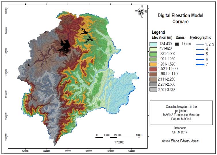
The hydrologically consistent digital elevation model of the Cornare's jurisdiction is shown in Figure 4. The DEM shows land with elevations from 134 m to 3,378 m, which agrees with what was described by Cornare (2005), who stated that the jurisdiction counts with a minimum altitude of 200 m on the plain of the Magdalena Medio and a maximum of 3,340 m on the hill of Las Palomas in the Paramo of Sonsón.
The declivity map is shown in Figure 5. The surface relief categories according to IDEAM (2013) are shown in Table 1. The jurisdiction of Cornare has terrains with very low, low and slightly moderate surface relief (0°-7°) mainly in the Cocorná Sur and Rionegro basins; moderate and moderately strong (7°-30°) in most of the territory and strong and very strong (30°->60°) mainly in the Samaná Norte, Samaná Sur and Arma basins; thus having geoforms from flood plains to rocky escarps passing through Vegas and alluvial piedmonts, torrential cones, thick and thin colluvial slopes, and rocky slopes.
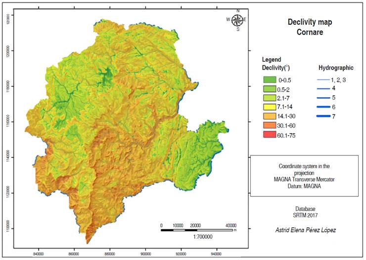
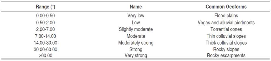
Figure 6 shows the comparisons between the real drainage mapped by the Dirección de Sistemas de Información y Catastro del Departamento Administrativo de Planificación de la Gobernación de Antioquia in blue color and the numerical drainage with 10, 20, 30, 40, 50, 60, 70 and 80 contribution cells in red color, in the jurisdiction of Cornare.
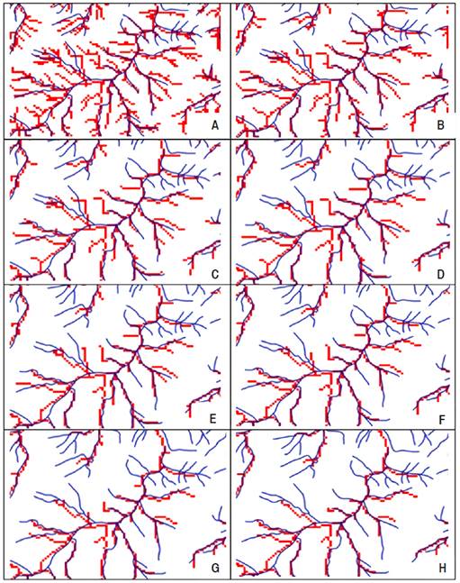
Figure 6 Comparison between the real drainage in blue and the numerical drainage in red, with a different contribution cells number: A) 10, B) 20, C) 30, D) 40, E) 50, F) 60, G) 70, H) 80.
To obtain the numerical drainage, it has a lower restriction, that is the lower number of accumulated flow cells, it causes a larger drainage network, since having a lower threshold, the network becomes denser.
With 10, 20, 30, and 40 cells, several false drainage channels are presented. With 50 and 60 cells, the drainage channels were more representative. With 70 and 80 cells, the numerical drainage did not reach the length of several channels, although they were the ones with the fewest false drainage channels. By visual comparison of a larger area, it was highlighted that the numerical drainage with 60 contribution cells was the one that best represented the hydrography of the Cornare's jurisdiction.
Figure 7 shows a cutout of the numerical drainage network with 60 contribution cells in Cornare's jurisdiction based on the order. The automatic delimitation calculated eight (8) drainage orders, one (1) being the drainage line with the least water and eight (8) the drainage line receiving the most water.
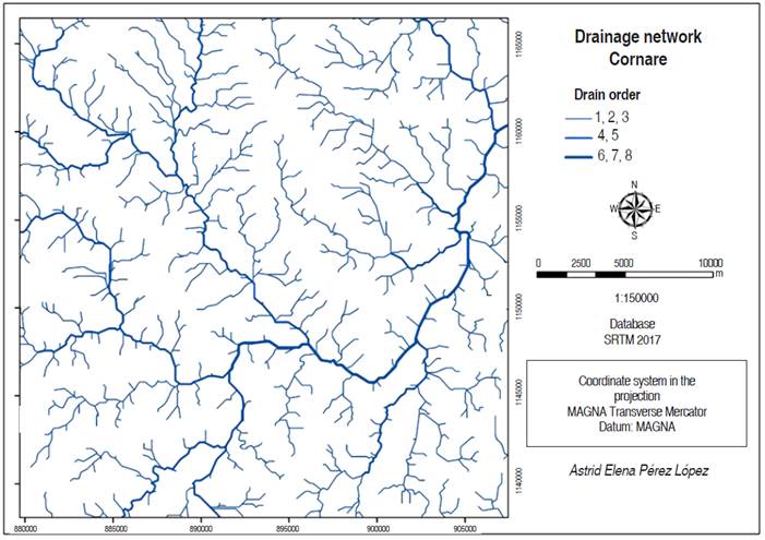
Figure 7 Cutout of the drainage network with 60 cells, from Cornare's jurisdiction based on the order.
Figure 8 shows the hydrographic map of the Cornare's jurisdiction based on the channels of 4th, 5th, 6th, and 7th order when the numerical drainage was obtained with 60 contribution cells.
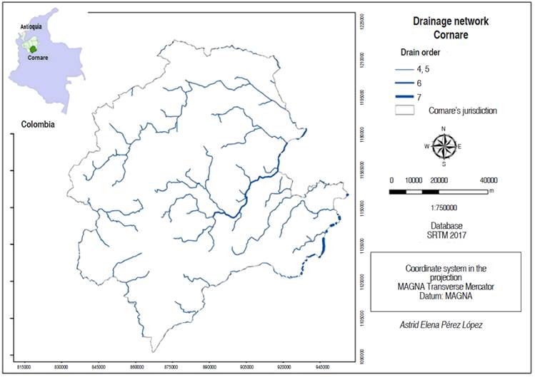
Figure 8 Hydrographic map of Cornare's jurisdiction based on channels of order greater than or equal to four (≥4).
Figure 9 shows the comparisons between the automatic delimitation of basins in the jurisdiction of Cornare based on drainage orders greater than or equal to six (≥6), five (≥5), and four (≥4) and the delimitation of basins made by the Instituto de Hidrología, Meteorología y Estudios Ambientales - IDEAM.
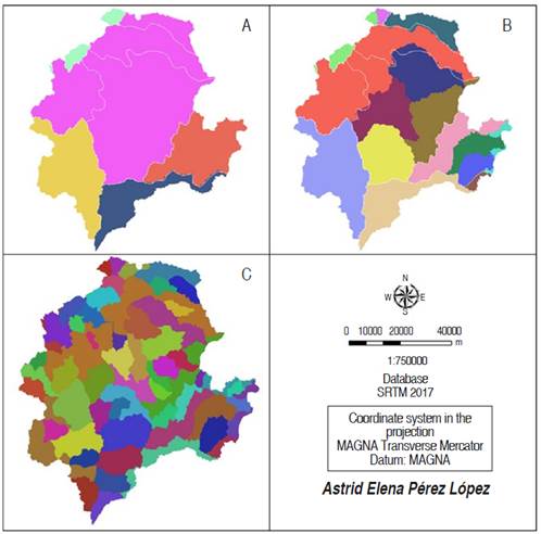
Figure 9 Comparisons between the automatic delimitation of basins in the jurisdiction of Cornare based on drainage orders greater than or equal to six (A), five (B) and four (C) and the basins delimitation made by IDEAM (white limit).
It was observed that the automatic delimitation based on the drainage order greater than or equal to six (≥6) (Figure 9A) was the one that came closest to the delimitation of hydrographic basins made by IDEAM, although there is a basin that grouped four (violet color). It is noteworthy that the basins limits correspond exactly to those of the basins delimited in the region, which confirms that the numerical drainage obtained with 60 contribution cells was the most indicated. Delimitations based on drainage orders greater than or equal to five (≥5) and four (≥4) (Figure 9B and 9C) present a greater basins number, 14 and >50, respectively, against eight (8) basins delimited in the region. The delimitation based on the drainage order greater than or equal to seven (≥7) divides the jurisdiction of Cornare into only two basins.
Figure 10 shows the comparisons between Cornare´s jurisdiction sub-basins automatic delimitation based on drainage orders greater than or equal to five (≥5), four (≥4), three (≥3) and two (≥2) and the sub-basins delimitation made by the Dirección de Sistemas de Información y Catastro del Departamento Administrativo de Planificación de la Gobernación de Antioquia.
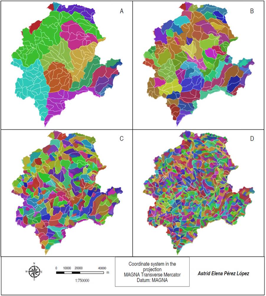
Figure 10 Comparisons between the automatic sub-basins delimitation in the Cornare's jurisdiction based on drainage orders greater than or equal to five (A), four (B), three (C), and two (D) and the sub-basins delimitation made by the Gobernación de Antioquia (white limit).
The automatic delimitation based on the drainage order greater than or equal to three (≥3) (Figure 10C) with 226 sub-basins was the closest to the hydrographic sub-basins delimitation by the Gobernación de Antioquia, to which it counts 165 sub-basins. The difference of 61 sub-bases shows that this automatic delimitation is not reliable or that the delimitation made by the Gobernación de Antioquia is obsolete. In comparison, the automatic delimitation based on the drainage order greater than or equal to five (≥5) (Figure 10A) inferred 15 sub-basins.
The automatic delimitation based on drainage order greater than or equal to four (≥4) (Figure 10B) calculated 63 sub-basins. The automatic delimitation based on drainage order greater than or equal to two (≥2) (Figure 10D) shows a number much greater than 226 sub-basins.
Determining morphometrics drainage indices orders greater than or equal to three (≥ 3), five (≥5), and six (≥6) different drainage density (Dd) and circularity index (Ci) values were found (Table 2).
Table 2 Averages morphometrics sub-basins indices in the jurisdiction of Cornare, according to the chosen drainage order.
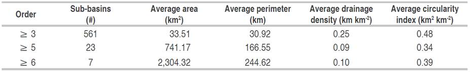
Differences in values are because Dd is inversely proportional to the area, so with a lower drainage order number, there is a greater sub-basins number and a smaller area for each one, so there is a Dd bigger. Also, by having a smaller area, there is a smaller total rivers length, which is directly proportional to Dd. According to Horton's classification (Horton, 1945), the Dd is between low and moderate, that is, the sub-basins in the jurisdiction of Cornare have moderate drainage, medium runoff effectiveness, and moderate infiltration capacity.
As for the Ci, this is inversely proportional to the perimeter, so with a smaller drainage order number, there is a smaller perimeter and a higher Ci. According to Müller (1953) and Schumm (1956) classification, the Cornare jurisdiction sub-basins have a moderate runoff level, tending to be more elongated than circulars, disfavoring the flooding processes and benefiting the runoff process. This agrees with the slope map generated by the DEM.
As the Ci tends to unity, the basin torrentiality increases, since the relative distances of the partition points, about a central one, do not present great differences, and the concentration-time becomes smaller; therefore, increases the possibility that the flood waves are continuous.
In elongated basins, the concentration times are quite different for almost all points in the basin, so the waters will gradually flow towards the main channel. In this way, the main channel will have a greater opportunity to drain part of its volume, before receiving rainwater in the most distant points and, therefore, the flow variations will be less wide and fast, reducing the risk of overflow and flooding in the watershed areas deposition. (Londoño, 2001).
According to Cornare (2012), for 186 sub-basins studied in the municipality of La Ceja, Dd values between 0.98 and 4.21 km km-2 were obtained. In the La Guayabal sub-basin in the municipality of Cocorná, the Dd was 3.61 km km-2 and its Ci was 0.39. The sub-basin order is four with 63 tributaries of order one, 16 of order two, and four of order three (Cornare, 2009b).
Montoya and Montoya (2009) found that the Los Andes sub-basin stream in the municipality of El Carmen de Viboral has a high Dd (7.17 km km-2), it has an area of only 2.87 km2, 94 tributaries with a total length of 20.58 km. Ramírez et al. (2007) found that the sub-basin of the El Salto stream, in the municipality of El Santuario has a Dd of 5.65 km km-2. Cornare (2009a) describes the La Corozal sub-basin of the municipality of Puerto Triunfo, with a main channel length of 4.06 km, a total tributary sum of 20.59 km, and a Dd of 3.18 km km-2. The sub-basin order is 4, with 27 tributaries of order one, five of order two, and two of order three.
The main rivers information is recent. According to the POMCAS (2017), the hydrographic basins of the Nare, Rionegro, Cocorná, Samaná Sur, Porce, and Arma rivers are well drained and elongated. Nevertheless, the Samaná Norte river basin is well-drained, but it has an oval round to oval oblong shape, that is, it can present torrential risks. Figure 11 shows an order greater than or equal to five (≥5) sub-basins Dd map in the Cornare´s jurisdiction, by obtaining the numerical drainage with 60 contribution cells. The Dd values ranged between 0.04 and 0.22 km km-2.
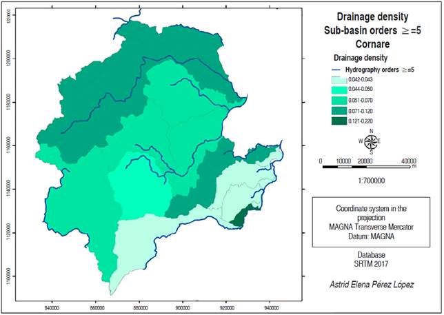
Figure 11 Map drainage density sub-basins order greater or equal to than five in the jurisdiction of Cornare.
Figure 12 shows order greater than or equal to five (≥5) sub-basins Ci map in Cornare´s jurisdiction, with 60 contribution cells to achieve the numerical drainage. The Ci estimates oscillate between 0.08 and 0.45 km2 km-2.

CONCLUSIONS
Digital elevation models SRTM availability and their information quality saves time and resources for conducting research and diagnostics aimed at the hydrologically consistent digital elevation models generation, which can also be used in areas that don´t have cartographic data available, as they allow to obtain information in a fast, efficient and standardized way.
In hydrographic basins and sub-basins automatic delimitation with the proposed methodology should pay special attention to determining the contribution cell number used to obtain the numerical network.
Basins and sub-basins automatic delimitation based on their drainage order did not come close to reality according to the databases used. This may be because the proposed methodology is unreliable or the databases used obsolete.
The morphometric indices drainage density and circularity index indicated that the sub-basins in the jurisdiction of Cornare have moderate drainage, moderate runoff level, and moderate infiltration capacity; they tend to be more elongated than circulars, disfavoring the flooding processes and benefiting the flow process.

