


Services on Demand
Journal
Article
 English (pdf)
 Article in xml format
 Article references
 Send this article by e-mail
Indicators
-
 Cited by SciELO
 -
 Access statistics
Related links
-
 Cited by Google
 -
 Similars in
SciELO
Similars in
SciELO -
 Similars in Google
Share

 Permalink
Actualidades Biológicas
Print version ISSN 0304-3584
Actu Biol vol.31 no.1 Medellín July/Dec. 2009
ARTÍCULOS DE INVESTIGACIÓN
THE HYDROCLIMATOLOGY OF GORGONA ISLAND: SEASONAL AND ENSO–RELATED PATTERNSA
HIDROCLIMATOLOGÍA DE LA ISLA GORGONA: PATRONES ESTACIONALES Y RELACIONADOS CON EL ENSO
Juan F. Blanco1
1 Docente. Instituto de Biología, Universidad de Antioquia. A. A. 1226. Medellín (Antioquia), Colombia. Correos electrónicos: jfblanco73@yahoo.com, blanco@matematicas.udea.edu.co.
ABSTRACT
Most small watersheds in the Tropical Eastern Pacific remain ungauged, and discharge analyses using gauge and simulated data have been published only for a few large rivers. I analyzed a 20–yr record of rainfall and stream discharge from Gorgona Island, a natural national park located 30 km offshore in the Pacific Ocean of Colombia to explore intra– and inter–annual patterns and drivers. Gorgona Island receives > 6.600 mm of annual rainfall thus feeding numerous permanent streams. Inter Tropical Convergence Zone–driven seasonal rainfall patterns (unimodal) were consistent regardless of interannual variability. However, a large yearly variation was observed between May and August. Monthly and annual rainfall in Gorgona Island was greater than at a neighboring continental–coastal area, suggesting the occurrence of orographic and convective rain. El Niño Southern Oscillation slightly influenced interannual variation in rainfall, but it strongly influenced stream discharge. The importance of the Chocó Jet Current and Meso–Scale Stationary Systems is discussed.
Key words: Chocó Jet Current, ENSO, Gorgona Island, rainfall, stream discharge, seasonality
RESUMEN
Muchas cuencas pequeñas en el Pacífico Oriental Tropical no poseen estaciones limnimétricas y solamente se han publicado análisis hidrológicos de unos pocos ríos. Se analizó un registro de 20 años de precipitación y caudales de la Isla Gorgona, un parque nacional natural ubicado a 30 km de la costa Pacífica colombiana para identificar patrones de variabilidad intra– e inter–anual. La Isla recibe > 6.600 mm de lluvia anualmente que alimentan numerosas quebradas permanentes. El patrón monomodal de precipitación es consistente a pesar de la variación interanual y determinado por la migración latitudinal de la Zona de Convergencia Intertropical. Sin embargo, una mayor variación entre años fue observada en el periodo mayo–agosto. Las lluvias mensuales y anuales fueron mayores que las de áreas costeras continentales vecinas, lo que sugiere la ocurrencia de lluvia orográfica y convectiva. El Niño – Oscilación Sureña influenció levemente la dinámica de la lluvia, pero fuertemente la del caudal. Se discute la importancia de otros sistemas atmosféricos como la Corriente de Chorro del Chocó y Sistemas Estacionarios de Meso–Escala.
Palabras clave: caudal, Corriente de Chorro del Chocó, El Niño–La Niña, estacionalidad, Isla Gorgona, precipitación pluvial
INTRODUCTION
The Pacific region of Colombia, located at the Biogeographic Chocó, is one of the world's rainiest regions (annual average: > 10.000 mm; Mesa et al. 1997, Poveda 2004, Rangel y Arellano 2004), yet the hydroclimatology of small coastal watersheds is unknown. Most climatic stations are located at major human settlements, while gauging stations are along a few large rivers (Lobo–Guerrero 1993), with most low–order streams remaining ungauged (Restrepo and Kjerfve 2000). Although various climatic assessments are available for the Pacific region (Eslava 1993, Mesa et al. 1997, Poveda 2004, Rangel and Arellano 2004), it is unknown to what extent discharge in small streams may fit into the regional pattern. In addition, most large continental rivers of the Pacific drainage spring at high elevations, some even in the Andean region (> 2.000 m above sea level) (Lobo–Guerrero 1993). Therefore their hydrographs may reflect extra– regional influences (Restrepo and Kjerfve 2000), rather than the maritime climate of the lowlands. Based on precipitation, the Pacific region is divided into three climatic zones: northern, central, and southern (Mesa et al. 1997, Rangel and Arellano 2004). The central is the rainiest (> 6000 mm/ year). Gorgona Island lays offshore in the boundary of the central and southern zones, and it offers unique advantages for studying natural hydrographs relative to atmospheric processes in small coastal watersheds. Firstly, this island is a protected natural area since 1984, and it is therefore uniformly covered with tropical rain forests, and secondly, meteorological and stream (hydrological) gauging stations were installed in 1986.
The hydrology of Colombia is controlled in a great extent by the Inter Tropical Convergence Zone (ITCZ) and El Niño Southern Oscillation (ENSO) (Mesa et al. 1997, Poveda 2004), and the Pacific region is not an exception (Eslava 1993, Lobo–Guerrero 1993, Rangel and Arellano 2004). In addition, meso–scale systems (Mejía 1989 quoted by Rangel y Rudas 1990), local circulation, convection, and orbital movements are seemly important (Rangel 1995). The migration of the ITCZ produces bimodal hydrographs in the northern part of the country, and monomodal hydrographs in the southern parts (reviewed by Poveda 2004). The influence of ENSO on the interannual variability in rainfall and stream discharge has also been extensively studied in Colombia (reviewed by Poveda 2004). In general, the warm phase (El Niño) increases air temperature, reduces rainfall and stream discharge, as well as soil humidity. These effects are particularly stronger in the Western Cordillera and the Pacific region. Opposite patterns are observed during the cold phase (La Niña). Dry and rainy years were reported in several localities in the central (Condoto and Buenaventura) and the southern (Guapi and Tumaco) parts of the Biogeographic Chocó but a connection with ENSO has not been tested (Rangel and Rudas 1990). In addition, a high incidence of droughts was reported for Guapi (1969–1985) in the vicinity of Gorgona Island. Finally, although interannual variability was observed in this island between 1986 and 1989, it did not affect seasonality (Rangel and Rudas 1990). To the knowledge of the author, freshwater discharge time series have not been studied at any small stream in the Pacific region of Colombia, particularly in Gorgona Island.
The objectives of this paper are the following: a) to test for insularity in Gorgona Island climate by comparing intra– and inter–annual rainfall variability against a neighboring continental area (e.g., Guapi); b) to quantify intra– and interannual variability; c) to relate inter–annual variability to ENSO; and d) to determine intra– and inter–annual patterns in stream discharge and the possible influence by ENSO.
MATERIALS AND METHODS
Study area. Gorgona Island is a 1.333 ha volcanic massif located in the continental shelf at 35 km off the Pacific coast of Colombia (figure 1). The climate is superhumid tropical maritime due to the high air temperature and humidity (26 ºC and 90%) year round (Rangel 1995, Rangel and Rudas 1990). Rainfall distribution throughout the year is monomodal, totaling 6.840 mm, while annual potential evapotraspiration is only 1.533 mm. Thus producing a positive water balance (even during March, the driest month) feeding more than 25 permanent low–order streams flowing directly to the ocean. Estimates of water discharge in the five largest streams range between 30 and 300 l/s (Sáenz 1988 cited by Crespo 1992). Up to 100 streams have been said to spring–out along the coastline during the rainy season. Rainfall and streamflow seasonal variability is seemly controlled by the ITCZ. The lowest rainfall occurs between December and April while the highest rainfall occurs between May and November.
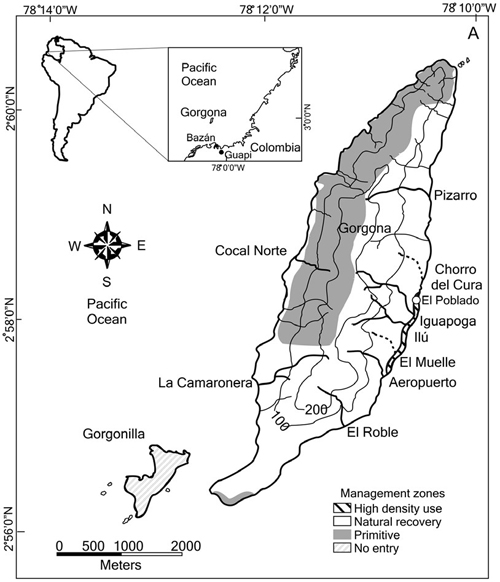
Figure 1. Location of Gorgona Island and Guapi at the Tropical Pacific, Colombia
The island is extensively covered by tropical rain forest and cloud forest despite its maximum elevation is only 338 m.a.s.l. Human influence on the island has been localized (UAESPNN–DTSO 2005). During the end of the 19th century and most of the 20th century the island was permanently inhabited, initially by farmers and lately by prisoners and officers of a high security prison installed in 1959. This prison was officially closed in 1984 when the island was designated as a national natural park. Most formerly deforested areas have been recovered into secondary forests. Current human activity (< 100 inhabitants) is restricted to ''El Poblado'' (3 ha) and interpretive trails.
Data and analyses. Monthly rainfall data were acquired from Instituto Nacional de Estudios Ambientales (IDEAM) station 5702501 (Gorgona), and monthly stream discharge for Quebrada Ilú (formerly known as Don Abad) from station 5702701 (Gorgona La Playa). Both stations were established in 1986, however, reliable water level and discharge data are only available since 1990 and 1996, respectively. Both stations are located in the coastal plain of Quebrada Ilú basin at 0303N, 7809 W, and 10 m.a.s.l (at nearly 100 m inland from the coastline). Monthly rainfall data were also acquired from IDEAM station 5304503 (Aeropuerto Guapi: 0234 N, 7754 W, 42 m.a.s.l.) located at the continental municipality of Guapi, 52 km to the East of Gorgona Island.In order to regionalize monthly rainfall, data were compared between Gorgona and Guapi using a Nested Analysis of Variance (Nested ANOVA) (Underwood 1997). Firstly, ''months'' were nested within stations to test for seasonal patterns, and afterwards, ''years'' were nested within stations to test for inter–annual patterns. Data were log–transformed when required. A ''surface'' (two–dimensional) model was constructed using the spline interpolation algorithm (AISN 1997) to simultaneously describe intra– and inter–annual variation in monthly rainfall. This algorithm is recommended for gridded data, such as in this case where months represent the x axis while years represent the y axis. Coefficients of variation were computed within– and among–years to test for seasonality and yearly patterns. A one–way ANOVA was used to compare monthly rainfall among years, but since a great interannual variability was detected between May and August (using a Levene's Test for Homogeneity of Variances), a new analysis was performed using those months only. Given the great variability of monthly rainfall from year to year, even during the rainy season, a Spearman rank regression analysis was conducted between minimum, median or maximum monthly rainfall and the Southern Oscillation Index (SOI). SOI data (1931–2008) were obtained from the Australian Government Bureau of Meteorology website (http:// www.bom.gov.au/climate/current/soihtm1.shtml).
Monthly stream discharge data were compared either ''among months'' or ''among years'' using One–way ANOVA. The Levene's Test for Homogeneity of Variances was conducted to test for inter–annual variability within months. Two–dimensional modeling was not possible due to the high number of missing monthly data. Similarly to the explained for rainfall, a subset of months was used for testing yearly patterns. Given the limited number of years available for regressing monthly discharge against SOI, monthly discharge was compared among SOI values (years) using planned post hoc contrasts. All statistical procedures were performed in STATISTICA® 6.0 (Statsoft, Tulsa, OK, USA).
RESULTS
Rainfall. Both annual and monthly rainfall were significantly different between Gorgona and Guapi. Mean total annual rainfall was significantly higher at Gorgona than at Guapi (6.661 and 4.897 mm, respectively) (table 1). Extreme annual rainfall scored 5.854 and 8.014 mm (2005 and 1992, respectively) in Gorgona, and 4.110 and 6.075 mm (1988 and 1998) in Guapi. In both sites maximum values exceeded mean rainfall in ca. 20% while minimum values showed a ca. 10% deficit. The yearly record in Guapi was rather incomplete due to: a) > 2 missing months in five years, and b) even 5 missing years.
Table 1. Annual rainfall during the 1988–2007 period for Gorgona and Guapi (Tropical Pacific, Colombia). Values with an asterisk (*) represent at least one missing month. The period 1991–1995 was not measured in Guapi. Mean 1 based on years with complete data; mean 2 based with all years in record. Rainfall deviations were computed only for years with complete data.
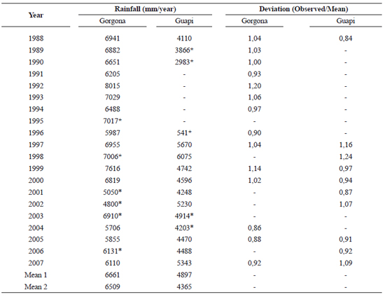
Monthly rainfall varied significantly throughout the year but not among years in both sites (table 2, figure 2). It was also significantly greater at Gorgona than at Guapi. In Gorgona, the drier period occurs bet ween Januar y and April, while rainy conditions are observed between May and December, with a slight reduction from July to August. In Guapi, peak rainfall was observed from April to June, while less rainfall was recorded during most of the year. A clearer pattern was observed when intra– and inter–annual variation were simultaneously modeled (figure 3). The intra–annual variability in monthly rainfall was greater than the interannual variability in Gorgona (49 and 40%, respectively), while it was identical in Guapi (42%). The intra–annual variability was damped in Gorgona (and to a lesser degree in Guapi) during 2002 and 2003.
In Gorgona, the inter–annual variability was slightly correlated with SOI. Thirteen negative (El Niño) SOI years and seven positive years were documented since 1980 (figure 4). The negative SOI condition was also more frequent during the past 40 years. Although the inter–annual variability in monthly rainfall was not significant either considering all months of the year or the rainiest months (May to August) (One–way ANOVA: F18, 53 = 1,07 p = 0,41) (figure 4), the minimum monthly rainfall during that period was marginally correlated with SOI (figure 5; Sperman Rank correlation: r = 0,41; N = 19; t = 1,85; p = 0,08). There was not significant correlation with the mean or maximum monthly rainfall. There was no cor relation with annual rainfall although it varied between –16% and +20%.
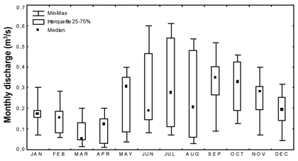
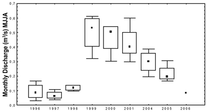
Stream discharge. Monthly discharge was significantly different among months (one–way was observed from April to June, while less ANOVA: F11,85 = 3,30 p < 0,001; figure 6). Greater variability was observed between May and August (Levene's Test for Homogeneity: F11,85 = 3,94 p < 0,001). There were also significant differences in monthly discharge among years (one–way ANOVA: F8,88 = 8,8 p < 0,001; Levene's Test for Homogeneity: F8,88 = 2,96 p < 0,001). When only the rainiest months (May–Aug) were included, the differences among years increased (and the variability within year was reduced) (figure 4: One–way ANOVA: F8,22 =14,75 p < 0,001; Levene's Test for Homogeneity: F8,22 = 0,88 p > 0,05). Significant differences were observed by only including January–April or October–December. The inter–annual variation i n monthly discharge was related to SOI: a) during 1996–1997: negative SOI and low discharge, b) during 1998: positive SOI and low discharge, c) during 1999–2000: positive SOI and high discharge, and d) during 2001–2005: negative SOI and intermediate (but decreasing) discharge. None analysis was conducted using annual rainfall because there were only five years with complete records.
Table 2. Results of Nested ANOVA comparing monthly rainfall between Gorgona and Guapi (Tropical Pacific, Colombia). Model 1: Months nested within site. Model 2. Years nested within site
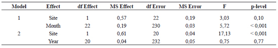
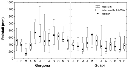
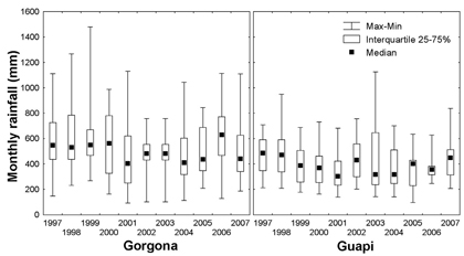
Figure 2. Variability of monthly rainfall at Gorgona and Guapi (Tropical Pacific, Colombia). A. Intraannual variation.b. Interannual variation
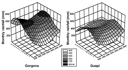
Figure 3. Surface models showing intra– and inter–annual dynamics of monthly rainfall at Gorgona and Guapi (Tropical Pacific, Colombia), period of record: 1996–2008
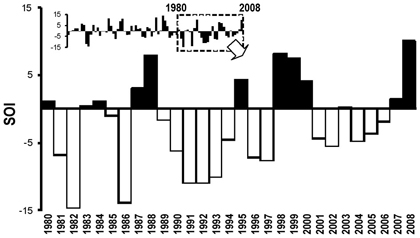
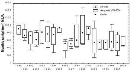
Figure 4. A. Southern Oscillation Index (SOI) dynamics (1980–2008; inset shows data since 1931 and enlarged area). b. Interannual dynamics of monthly rainfall during the May– August period
DISCUSSION
Using a 20–year record, this study significantly expanded the monthly and an nual rainfall statistics previously repor ted for Gorgona Island (1986–1988: Rangel and Rudas 1990). Being located in the Pacific region of Colombia, it received an enormous amount of rainfall (median > 6.600 mm /year). This area also corresponds to the climatic Equator (3º N). However, mont h ly a nd a n nu al rai n fall i n Gorgona Island were consistently higher than at the neighboring continental area (e.g., Guapi, as reported by Rangel and Rudas 1990), thus suggesting that local factors further contribute to increase rainfall levels. Contrar y to the central and northern parts of the Pacific coast, the souther n par t (south to the río Micay) exhibits an extended coastal plain (> 120 km, Rest repo and Kjerf ve 2000) and therefore the humid winds from the Pacific Ocean are not intercepted by the smooth coastal relief (Rangel and Arellano 2004). On the contrary the mid elevation of Gorgona Island (330 m) seems to be high enough to force marine wind and breeze to uplift thus promoting orographic rain as suggested by Rangel and Rudas (1990). Orographic forcing of rainfall and clouds is an important meteorological process in islands (van der Molen 2002). Another important process for insular hydrology may be cloud interception as observed in rain and cloud forests in the Caribbean (e.g., Asbury et al. 1994). The dense tropical forest in Gorgona Island may further promote high evapotranspiration and convective rain (Rangel and Rudas 1990), as reported for other areas of the country (Poveda 2004) and islands in the Caribbean (Schellekens 2000). Actually, rain showers in Gorgona commonly occur at night and early in the morning (Rangel 1995, JF Blanco personal observations), possibly as a consequence of convection of wet–air masses. Poveda (2004) recently described that diel rainfall patters are evident in the Andes (e.g., showers between 8 and 11 am have a low probability), and are strongly influenced by local factors (e.g., topography, vegetation). A similar pattern was observed in Puerto Rican rainforests (Schellekens 2000).
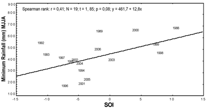
Figure 5. Spearman–rank correlation between the Southern Oscillation Index (SOI) and the minimum monthly rainfall recorded between May and August for various years
 A
A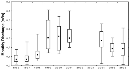 B
B
 C
C
Figure 6. Variability of monthly discharge at Gorgona (Tro– pical Eastern Pacific, Colombia). A. Intraannual variation. B. Interannual variation including all months of the year. C. interannual variation only including the May–August period
The present st udy shows that int ra–an nual variability in rainfall is greater than inter– annual variability in Gorgona Island. This pattern is more evident that at the continental part of the Southern Pacific coast of Colombia (e.g., Guapi), probably due to the orographic forcing. The intra–annual variations in rainfall at both study sites were clearly related to the latitudinal migration of the ITCZ as reported in previous studies (Rangel and Rudas 1990, Rangel 2004, Poveda 2004). The monomodal, two–seasonal pattern was confirmed using the long–term dataset.
Contrary to observations in the Andean zone of Colombia, ENSO had a weak influence on rainfall dynamics over Gorgona Island. This is probably due to the fact that the anomaly of the Souther n Oscillation becomes more evident during the second semester of the year. Actually, the period May–August showed the greatest inter–annual variation in rainfall. The minimum rainfall observed during this per iod was posit ively cor related with the SOI, suggest i ng t hat ENSO set s baseli ne at mospher ic cond it ions over t he Tropical Eastern Pacific region. Additional atmospheric processes further modulate air circulation and humidity. It was previously suggested that climate at Gorgona Island was also affected by local circulation, orbital movements, and Meso–scale processes ( Rangel a nd Rudas 1990, Rangel 1995). Hydrological research over the last decade demonstrated that Mesoscale Convective Systems (MSCS) are important in the Pacific Ocean (Mejía and Poveda 2005), because instant rainfall intensity and frequency is greater in this area than at the continent between June and August, and atmospheric parcels of precipitation water are significantly greater. Mejía and Poveda (2005) showed that a large parcel of low convection–inhibiting energy (associated with extreme atmospheric instability) is present year–round off the Pacific coast of Colombia. This atmospheric instability is reduced above the Andes and the Amazon. Other atmospheric kinematic and thermodynamic indices were more in agreement with the oscillations of the ITCZ. Figure 7 shows the occurrence of several MSCS over Gorgona Island during 2008 and 2009 when fieldwork was conducted at the streams by our research group (see accompanying papers).
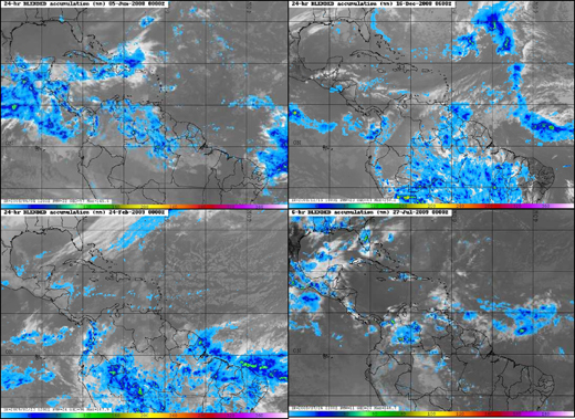
Figure 7. GOES satellite imagery showing the Chocó Jet Current (CJC) forcing convective rainfall in the western slope of the Western Cordillera of Colombia, June and December 2008. Note how the CJC weakened during 2009. Mesoscale Convective Systems were also observed over the Pacific Ocean during December 2008 and February 2009. Note the extratropical cold front in February 2008 and tropical waves in the Caribbean and Central Atlantic in June and December 2008, and February 2009. Public–domain images downloaded from the US Naval Research Laboratory website (http://www.nrlmry.navy.mil/tropics–bin)
The Chocó Jet Current and thermal gravity waves are important drivers of rainfall in the Pacif ic region studied over the last decade (Mejía and Poveda 2005, Mesa et al. 1997, Poveda 2004). The Chocó Jet is a low elevation superficial current that transports an enormous amount of humidity from the Pacific Ocean eastwards to the continent (it is estimated to be half of the Magdalena River's water discharge, the largest in Colombia). It interacts with the topog raphy and the Eastern Trade Wi nds favoring convective rain in the Western Region of Colombia. It has a seasonal behavior being stronger between May and November. It may also be affected by ENSO because it weakens during EN and reinforces during LN. Figure 7 also shows the evolution of the Chocó Jet Current during 2008 and 2009.
A stronger influence of ENSO was observed on Gorgona Island's stream discharge, as observed in large rivers in the Pacific Coast (e.g., Río San Juan: Restrepo and Kjerve 2000). This effect may be mediated by air temperature, leaf litter–layer and soil humidity thus affecting superf icial and subsuperf icial r unoff to the streams. To generate overland runoff or sub– superficial flow through the soil profile nearby stream channels, rainfall intensity must be greater than soil–infiltration and percolation rates (Chang 2003). After prolonged droughts, most of the rainfall is retained in the soil profile consequently affecting the amount of runoff and therefore delaying the response of streamflow. In addition, other watershed storages must firstly be recharging prior to runoff generation. This particular process may explain the low stream discharge observed during 1998 despite it was a significantly positive SOI (wet year). Although air temperature remains fairly constant throughout the year (± 2º C, Rangel and Rudas 1990), it may track sea surface temperature (SST) that is highly variable among years relative to ENSO (Philander 2004). Air temperature data are available from Gorgona Island climatic station to test this hypothesis in the future. Preliminary data show that while SST changes ± 1.5 ºC within the year (Giraldo et al. 2008, Zapata 2001), a 3 ºC warming occurs during EN years (1950–1998 record, Zapata et al. 2001). In addition, a reduction of 6 ºC was observed between 1999 and 2000 (Zapata 2001). Thus during dry years, the watersheds in Gorgona Island may not only experience a reduction in overland flow but an increase in soil water evaporation and plant uptake, further contributing to a reduction in stream flow.
The marked seasonality of rainfall and discharge, as well as the ENSO - driven inter-annual dynamics in discharge observed in Gorgona Island are important for shaping stream communities and ecosystem processes. In particular, since flooding is highly predictable, stream communities may build up during the dry season and may be washed out during the rainy season (Gómez et al. 2009 in this issue) similarly to other seasonal Neotropics (e.g., Flecker and Feifarek 1994 cited by Allan 1995). In addition, leaf litter accumulates during the dry season and flushes during the rainy season (see Valencia–G. et al. 2000 in this volume). Unlike the aseasonal Tropics, biological and physical controls of community structure and ecosystem processes alternate in Gorgona Island between dry and rainy seasons, respectively. On the other hand, inter–annual variability in stream communities has been reported in the Neotropics, but in few cases related to ENSO (Blanco 2003). Therefore, Gorgona Island may be useful for testing theories on flood disturbance at various temporal scales. By understanding the influence of interannual variability in stream communities, lessons can be learned for foreseeing climate change impacts (Carpenter et al. 1992). It is also recommended to further understand forest and stream ecology and hydrology under the different past and present land covers in the island.
ACKNOWLEDGEMENTS
This paper is par t of the ''Gorgona Island Stream Bio–Assessment'' project funded by the Comité Central de Apoyo a la Investigación (CODI), Universidad de Antioquia. Research permit DTSO–G–03/08 was issued by Unidad Administrativa Especial del Sistema de Parques Nacionales Naturales. Climate and discharge datasets were facilitated by Nancy Murillo, Corazón Aguiño, Héctor Javier Montaño at Gorgona Island National Natural Park, and by Nelson Carvajal at Instituto Colombiano de Estudios Ambientales, Pasto Regional Office. I also thank Sara Raquel López for formatting tables. Comments from Andrés F. Osorio are acknowledged.
REFERENCES
1. AISN. 1997. Table Curve 3D. Automated surface fitting and equation discovery. Version 3.0. User's manual. United States. p. 1–10. [ Links ]
2. Allan D. 1995. Stream ecology. Structure and function of running waters. Dordrecht: Kluwer. p 387. [ Links ]
3. Asbury CE, McDowell WH, Trinidad–Pizarro R, Berrios S. 1994. Solute deposition from cloud water to the canopy of a Puerto Rican montane forest. Atmospheric Environment, 28: 1773–1780. [ Links ]
4. Blanco JF. 2003. Interannual variation of macroinvertebrate assemblages in a dry–forested stream in Western cordillera: A role for El Niño and La Niña? Boletín Ecotropica, 37: 3–30. [ Links ]
5. Carpenter SR, Fisher SG, Grimm NB, Kitchell JF. 1992. Global change and freshwater ecosystems. Annual Review of Ecology and Sytematics, 23: 119–139. [ Links ]
6. Chang M. 2003. Forest hydrology. An introduction to water and forests. Boca Raton (FL): CRC Press. p. 373. [ Links ]
7. Crespo R. 1992. Estudio básico del sistema hidrológico de las lagunas Tunapurí y Ayantuna en la Isla Gorgona del litoral Pacífico colombiano. [Tesis de pregrado]. [Cali: (Colombia)]. Facultad de Ingeniería Agrícola, Universidad del Valle. [ Links ]
8. Eslava JA. 1993. Climatología. En: Leyva P, editor. Colombia Pacífico tomo I (Colombia): Fondo para la Protección del Medio Ambiente –FEN– Colombia. http://www.lablaa.org/blaavirtual/faunayflora/pacific1/cap10.htm. Accessed on August 17, 2009. [ Links ]
9. Giraldo A, Rodríguez–Rubio E, Zapata F. 2008. Condiciones oceanográficas en isla Gorgona, Pacífico oriental tropical de Colombia. Latin American Journal of Aquatic Research, 36: 121–128. [ Links ]
10. Gómez–Aguirre AM, Longo–Sánchez MC, Blanco JF. 2009. Macroinvertebrate assemblages in Gorgona Island streams: spatial patterns during two contrasting hydrologic periods. Actualidades Biológicas, 31(91): 161–178. [ Links ]
11. Lobo–Guerrero A. 1993. Hidrología e hidrografía. En: Leyva P, editor. Colombia Pacífico tomo I (Colombia): Fondo para la Protección del Medio Ambiente –FEN– Colombia. http://www.lablaa.org/blaavirtual/faunayflora/pacific1/cap9.htm. Accessed on August 17, 2009. [ Links ]
12. Mejía JF, Poveda G. 2005. Ambientes atmosféricos de Sistemas Convectivos de Meso–escala sobre Colombia durante 1998 según la misión TRMM y el re–analysis NCEP/NCAR. Revista de la Academia Colombiana de Ciencias, 29: 495–514. [ Links ]
13. Mesa O, Poveda G, Carvajal LF. 1997. Introducción al clima de Colombia. Medellín (Colombia): Universidad Nacional de Colombia, Sede Medellín, Facultad de Minas. p. 390. [ Links ]
14. Philander SG. 2004. Our affair with El Niño. Princeton (NJ). Princeton University Press. p. 275. [ Links ]
15. Poveda G. 2004. La hidroclimatología de Colombia: una síntesis desde la escala inter–decadal hasta la escala diurna. Revista de la Academia Colombiana de Ciencias, 28: 201–222. [ Links ]
16. Rangel O, Arellano H. 2004. Clima del Chocó Biogeográfico de Colombia. En: Rangel JO, editor, Colombia: Diversidad biótica IV: El Chocó biogeográfico/ Costa pacífica. Bogotá: Instituto de Ciencias Naturales, Universidad Nacional de Colombia. p. 39–82. [ Links ]
17. Rangel O, Rudas A. 1990. Macroclima de Gorgona y de la región costera aledaña. En: Aguirre J, Rangel O, editores. Biota y ecosistemas de Gorgona. Bogotá (Colombia): Fondo FEN. p. 13–41. [ Links ]
18. Rangel O. 1995. Islas de Gorgona y Gorgonilla. En: Rangel O, editor. Colombia: Diversidad Biótica I. Bogotá: ICN– UNAL–INDERENA. p. 145–154. [ Links ]
19. Restrepo J, Kjerfve B. 2000. Water discharge and sediment load from the Western Slopes of the Colombian Andes with focus on Río San Juan. The Journal of Geology, 108: 17–33. [ Links ]
20. Schellekens J. 2000. Hydrological processes in a humid tropical rain forest: a combined experimental and modelling approach. [Ph.D. thesis]. [Amsterdam (The Netherlands)]. Vrije University. p. 158. [ Links ]
21. UAESPNN–DTSO. 2005. Plan de Manejo Parque Nacional Natural Gorgona. Resumen Ejecutivo. Cali: Unidad Administrativa Especial del Sistema de Parques Nacionales Naturales de Colombia Dirección Territorial Suroccidental. SUT 021105. [ Links ]
22. Underwood AJ. 1997. Experiments in ecology. Cambridge University Press. Cambridge, UK. p. 504. [ Links ]
23. Valencia–G. SM, Pérez–Z. GA, Lizarazo–M. PX, Blanco JF. 2009. Patrones espacio–temporales de la estructura y composición de la hojarasca en las quebradas del PNN Gorgona. Actualidades Biológicas, 31(91): 197–211. [ Links ]
24. van der Molen MK. 2002. Meteorological patterns of land use change in the maritime Tropics. [Ph.D. thesis]. [Amsterdam (The Netherlands)]. Vrije University. p. 262. [ Links ]
25. Zapata F. 2001. Formaciones coralinas de Isla Gorgona. En: Barrios LM, López M, editores. Gorgona marina: contribución al conocimiento de una isla única. Serie Publicaciones Especiales No. 7. Santa Marta (Colombia): INVEMAR. p. 27–40. [ Links ]
26. Zapata F, Vargas–ángel B, Garzón–Ferreira J. 2001. Salud y conservación de las comunidades coralinas. En: Barrios LM, López M, editores. Gorgona marina: contribución al conocimiento de una isla única. Serie Publicaciones Especiales No. 7. Santa Marta (Colombia): INVEMAR. p. 41–50. [ Links ]
Recibido: mayo 2009;
Aceptado: noviembre 2009.

