


Serviços Personalizados
Journal
Artigo
 texto em
  Inglês (pdf)
 Artigo em XML
 Referências do artigo
 Enviar este artigo por email
Indicadores
-
 Citado por SciELO
 -
 Acessos
Links relacionados
-
 Citado por Google
 -
 Similares em
SciELO
Similares em
SciELO -
 Similares em Google
Compartilhar

 Permalink
Revista de Arquitectura (Bogotá)
versão impressa ISSN 1657-0308versão On-line ISSN 2357-626X
Rev. Arquit. vol.20 no.2 Bogotá jul./dez. 2018
https://doi.org/10.14718/revarq.2018.20.2.1562
Section
Urban landscape and public space as an expression of everyday life
* Arquitecta. Facultad de Arquitectura y Artes, Universidad de Los Andes. Mérida (Venezuela) Magíster Scientiae en Desarrollo Urbano Local, Mención Diseño Urbano, Universidad de Los Andes. Mérida (Venezuela) Doctora en Ciencias Humanas, Facultad de Humanidades y Educación, Universidad de Los Andes. Mérida (Venezuela) Docente e Investigadora (2016-2018) en la Pontificia Universidad Católica del Ecuador, sede Ibarra. http://orcid.org/0000-0002-7019-9022. mbafaaula@gmail.com. Pontificia Universidad Católica del Ecuador. Ibarra (Ecuador) Escuela de Arquitectura
Given that urban landscape is the expression of everything perceivable in a city’s public spaces, the analysis of urban attributes allows identifying patterns, sequences, and units in the urban landscape that lead to establishing design criteria in terms of visual quality. The paper proposes to study the attributes of the visual and functional quality of urban landscapes, including physical attributes: physical-spatial configuration, activities, biodiversity and diversity; as well as psychological attributes: physical integrity and aesthetic expression, which are applied to the assessment and design of public spaces in a sector of the historic center of the city of Mérida (Venezuela). The methodological approach of the multidimensional construction of urban landscapes is used to explain conceptual aspects that affect the perception of public spaces, in relation to the attributes of urban space. This assumption suggests further aspects that demonstrate its usefulness for future research and design proposals on urban landscape.
Keywords: Urban analysis; urban design; human ecology; collective space; urban indicators; urban perception
Dado que el paisaje urbano es la expresión de todo lo que es posible percibir en los espacios públicos de la ciudad, el análisis de los atributos urbanos permite identificar patrones, secuencias y unidades del paisaje urbano, que conducen a establecer criterios de diseño en términos de calidad visual. Se propone el estudio de los atributos de la calidad visual y funcional del paisaje urbano, entre los que se destacan atributos físicos como: configuración físico-espacial, actividades, biodiversidad, diversidad y atributos psicológicos: como integridad física y expresión estética, estos son aplicados a la valoración y diseño del espacio público en un sector del centro histórico de la ciudad de Mérida, Venezuela. Bajo el enfoque metodológico de la construcción multidimensional del paisaje urbano, se explican los aspectos conceptuales que inciden en la percepción del espacio público, en relación con los atributos del espacio urbano. La comprensión observada, plantea futuros aspectos que demuestran su utilidad para realizar propuestas de investigación y diseño sobre el paisaje urbano.
Palabras clave: Análisis urbano; diseño urbano; ecología humana; espacio colectivo; Indicadores urbanos; percepción urbana
Dado que a paisagem urbana é a expressão de tudo o que é possível perceber nos espaços públicos da cidade, a análise dos atributos urbanos permite identificar padrões, sequências e unidades da paisagem urbana que conduzem ao estabelecimento de critérios de desenho em termos de qualidade visual. Este trabalho propõe o estudo dos atributos da qualidade visual e funcional da paisagem urbana, entre os quais são destacados atributos físicos como: configuração físico-espacial, atividades, biodiversidade e diversidade; e atributos psicológicos como: integridade física e expressão estética, aplicados à avaliação e ao desenho do espaço público em um setor do centro histórico da cidade de Mérida (Venezuela). Com base no enfoque metodológico da construção multidimensional da paisagem urbana, os aspectos conceituais que incidem na percepção do espaço público são explicados, no que diz respeito aos atributos do espaço urbano. A compreensão observada propõe futuros aspectos que demonstram a sua utilidade para realizar propostas de pesquisa e desenho sobre a paisagem urbana.
Palavras-chave: análise urbana; desenho urbano; ecologia humana; espaço coletivo; indicadores urbanos; percepção urbana
Introduction
This article examines the relationship between the concepts of urban landscape and public space, understood as the place where different attributes inherent to the human condition are expressed, based on physical and psychological conditions.
In order to illustrate the relevance and usefulness of this relationship, this paper presents an analysis and design carried out by a group of seventh semester architecture students from the Faculty of Architecture and Design at the Universidad de Los Andes, Mérida (Venezuela). The study was completed in the course entitled “Architectural Design Workshop 70,” after finishing other courses that complement the understanding of the approach proposed for the workshop, since together with “Workshop 80,” they are part of the synthesis cycle at the BA program, prior to initiating the final special degree work.
The above mentioned approach proposes the study of context, as well as the increasing complexity of variables that affect it, in order to make architectural design decisions.
This type of studies are currently developed under the coordination of the author, in the historic center of the city of Ibarra (Ecuador), to determine its physical-spatial structure based on the analysis of the visual quality of its landscape. Additionally, the method has been applied in the course entitled “Architecture Workshop” with seventh-semester students at the Pontificia Universidad Católica del Ecuador, Ibarra campus.
The paper defends the hypothesis that the study of urban landscape attributes results in a diagnosis oriented to decision-making regarding the design of public space in a city, which increases visual quality.
According to different authors (Borja, 2002; Rodríguez, 2005; Segovia & Jordán, 2005), public space is a place of coexistence, encounter, and social equity, given the coexistence of citizens in it. On the other hand, it reflects the evolution of the human condition from social, cultural, economic, political, and natural perspectives, which are associated with a system of anthropic and natural values (McHarg, 2000). Its configuration and design has been carried out, throughout history, by urban planners and architects, as well as by the citizens’ own actions, who created, transformed and adapted it, motivated by their desires and needs, in search of a “common, collective space,” in the sense proposed by Arias-Romero et al. (2016, p.10).
The social dimension includes educational level, values, morals, ethics, and aspirations that affect human behavior. As a group and as individuals, human beings externalize their needs in the environment that surrounds them. The cultural dimension encompasses the sphere of values, traditions, customs, artistic expressions, the history and human evolution of each place, which leads to and strengthens appropriation and the sense of belonging. The economic dimension is motivated by the need for trade that leads to human interaction and produces particular urban dynamics in public spaces. Policy provides individuals and groups with an opportunity to participate in decision-making, and to express their ideas about the management of the city’s public spaces in these same spaces. Finally, no less important, the natural dimension represents the primal condition of man based on his sensitivity towards biodiversity.
This approach recognizes a structural reasoning oriented to the “multidimensional construction of sustainable urban landscape,” described by Briceño Owen and Contreras (2011, p. 100), where “public space ceases to be an instrument for the physical cohesion of the city, and becomes an active and permanent discussion strategy in all its dimensions, opening the way to a cultural debate on public space and, consequently, to having a right over it” (Arias-Romero et al., 2016, p. 13).
To make this approach operational, sequences and units are key concepts for the structured treatment of landscape in public spaces. Each unit, determined in the light of its attributes, facilitates the process of analysis and design. Sequence contributes to a greater goal, by achieving an interconnection between urban spaces and improving their aesthetic expression and, consequently, their quality (Matsuoka & Kaplan, 2008; Lynch, 1992; Cullen, 1974; Rapoport, 1974).
Incorporating the study of urban landscape attributes helps to understand urban complexity as a result of the actions undertaken by people, which, for better or for worse, determines what happens in the city’s public space.
An urban landscape that reflects its purpose and is pleasing to the eyes of people indicates processes of human adaptation to the environment they inhabit. Integral actions on the public space, which are respectful at the same time with each encountered reality, improve the quality of life of those who enjoy it, that is, citizens. Understanding the urban landscape of historic centers, such as the one presented here, constitutes a key instrument for the management of heritage sites, in a dynamic and changing reality.
Theoretical-conceptual framework
Perception of public space
Conditioned or motivated by social, cultural, economic, political, and natural dimensions, the space people travel through is, in turn, limited by its own characteristics and the form of displacement. During a journey, shapes, colors, many or few details can be perceived, depending on the means of transport used; wide and short views provide information according to the observer’s location. Hence, public space exists through its quality, by and for those who walk through it, who are its main priority, the reason of its existence, planning, and design: pedestrians.
On one hand, the primary interest falls on the user and, on the other, on the formal qualities and functional characteristics of this space. The city’s public spaces awaken different sensations, and the incentive of people to travel through them depends on these feelings; the design of public spaces should be oriented then to persuade and invite pedestrians to use them.
The objectives of public space design are oriented on two levels: the physical-objective level, which seeks to understand images from the environment, where different elements and ensembles show their specific characteristics; and the psychological-subjective level, which aims to understand the mediation process that exists between the observer and the observed, as a “human and environmental phenomenon” (Nassauer, 2012, p. 222). Values, culture, and education form part of the human characteristics that condition and may affect what is perceived, including the state of mind. Pleasure and exaltation (Russell, 1980), as well as an affective relationship with landscape can influence how an experience is judged (Chenoweth & Gobster, 1990).
In an objective sense, public space displays conditions and a diversity of elements that generate responses in people and influence their behavior. In a subjective sense, the notion of landscape refers to the perception of objects that conform an immutable reality that lead to apprehending, responding to, and interpreting said reality. According to Gavrilidisa et al. (2016), these senses correspond to the perspective of the environment and landscape, respectively. These ideas are integrated through the physical and psychological attributes considered for the study of the ecology and aesthetics of urban landscape and its visual quality (Briceño, 2009), presented in this work.
Studies about the quality of public space, in relation to factors inherent to human beings and their way of perceiving the environment, are associated with previous research related to human behavior; this implies observing what people do when they fix their attention on what satisfies them. When this happens, “appropriation and sense of belonging are triggered,” as proposed by Sevilla-Buitrago (2014, p. 56). Indeed, a careful observation of the behavior of people, what they do, why, how and when they use public space, with whom they share it, among others, are questions that inform the research of Danish town planners Jan Gehl (2005), Jan Gehl , Lars Gemzøe, Sia Karnaes and Britt Sternhagen Søndergaard (2006).
By defining urban spaces as significant places of collective existence, essential for the development of cities and their integrative relationship with inhabitants, these urban planners have developed 12 principles that contribute to assessing when a place can be qualified as a good public space. These are: protection from traffic, safety, protection from unpleasant sensory experiences, space for walking, spaces for staying, places to sit down, possibility to observe, opportunity to talk, places to do exercise, human scale, possibility of taking advantage of the climate, and a good sensory experience.
Such criteria are used to design future public spaces or to improve existing places with some deficiencies, such as absence of lighting, benches to sit on, elements for protection from sun or rain, unpleasant views, among others. When undertaking a project of this nature, Jan Gehl (2005) suggests that people should be asked to report on the needs they cannot meet in their cities and then to describe what is missing to satisfy these needs.
Undoubtedly, these criteria refer to the psychological level. Public space is expected to provide feelings of protection, safety, comfort, accessibility, freedom, pleasure, and surprise. These can facilitate the work of designers while elaborating specific projects with a conceptual orientation based on modalities of perception, as well as help to evaluate community preferences in order to satisfy specific needs, or to study the impact of projects, their evolution and possible improvements over time. This last aspect is included in the spatial-temporal notion of urban landscape attributes, in relation to visual quality and design concepts, which are part of the analysis and intervention process in different sectors, and help to form sequences and structure the images of the urban visual environment.
Every intervention involves establishing relations between the observer and the qualities of the landscape and its elements, through scale and proportion, the characteristics of the route, the surfaces on which people walk, the objects that offer comfort and those that animate public spaces, either because of their usefulness or because of the beauty they contribute to the world. All of which is perceived in manageable distances for the human body and vision.
Urban landscape attributes observed in public space
Public space is, then, a collective domain, “the place used by the public” (Maimunah et al., 2015, p. 363); among others, streets, squares, and parks represent this urban concept for people. The eco-aesthetic attributes of landscape focus on the relationship between space and the observer, between objective and subjective features.
The interaction of people with their external world is linked to the modalities of visual, auditory, olfactory, tactile, and kinesthetic perception. Although visual perception contributes 80% of the information that comes from the outside world, and it is fundamental to understand the cohesion of urban ensembles, there are other factors that significantly affect the quality of space. For example, a walk can be seen very cohesive, but when the surface to walk on is uncomfortable, it negatively affects its perception. Quality can be diminished when it does not complement the function the space must fulfill, or when it does interfere with it.
The analysis of attributes suggests that these characteristics define and allow conceptualizing landscape based on its visual quality (Briceño, 2009; Briceño et al., 2012), while forming a structure that can be analyzed by means of its components. When the emphasis falls on public space, it is viewed as a container of public life materialized in streets, intersections, and open spaces, in a “complex ensemble of forms and functions” that promotes the vitality of urban public space (Jalaladdini & Oktay, 2012, p. 665), and is understood as an expression of daily life. Thus, visual and functional analysis is focused on these places in order to interpret elements, patterns, units, changes, and trends that promote visual quality in space and time.
The attributes of spatial configuration, activities, diversity, biodiversity, physical integrity, and aesthetic expression, based on the analysis and diagnosis of their indicators and variables, lead to specific intervention actions in three moments: short, medium and long terms, which, illustrated through sequences, help to visualize changes introduced through design.
Spatial scope
Case study: Analysis of urban landscape attributes and public space in the Milla sector of the city of Mérida, Venezuela
The emphasis of the workshop, centered on the analysis of the eco-aesthetic attributes of urban landscape, its indicators and variables, presents a descriptive, affective, and evaluative approach. The physical attributes are: physical-spatial configuration, activities, biodiversity, and diversity; the psychological ones are associated with physical integrity and aesthetic expression regarding beauty and usefulness. These can be consulted in Briceño et al. (2011, 2012).
Methodology
Although the approach is illustrated through the results of an exercise, its application has been developed horizontally and vertically on the levels of Workshop 40 and 70, with different sections or parallels. The work begins with an explanation of the theoretical-conceptual and methodological contents, describing the results according to the complexity level implied by each Architectural Design Workshop.
The exercise comprises four phases: information gathering, analysis and diagnosis at city and sector scales in phase 1; structuring design in phase 2 (scale 1:500); sector design (detonator) in phase 3 (scale 1:250); and architectural design in phase 4. In each phase, the study seeks to understand the interaction between the city as a whole and the selected sector in order to carry out a specific study and design.
The experience, including the analysis of landscape attributes, has been developed since 2012 with students of the workshop, with different results in different sectors of the city of Mérida. A fundamental aspect was rigor in the collection of specific information, through the design of technical data sheets and their incorporation into the model proposed by Briceño and Gómez (2011) in order to facilitate the analysis of each aspect or concept discussed in class.
Results
The study began by defining different concepts and as an example the case of the Milla sector was presented, which is located in the central area of the city of Mérida (Figure 1) and is very important for the historical identity of the city.
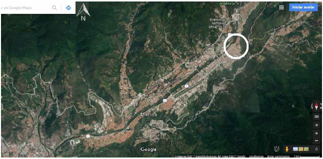
Source: Own elaboration based on a Google Maps satellite image, 2017 ©
Figure 1 City of Merida, Milla sector
Some figures were selected to illustrate the information of the analysis carried out by students; the design proposal is explained later.
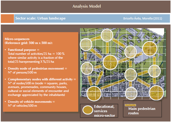
Based on the physical-spatial configuration attribute, public spaces are defined by their horizontal and vertical plans. There, the objects located around give shape to the background and generate an urban space contained by the proximity, regularity, and proportional height of the elements that provide the necessary vertical reference so that the subject is able to orient himself within the space and identify it. Beyond the aesthetics of a building or the adopted style, architectural form can contribute to creating or disassembling public spaces in a city. On the one hand, configuration is shown through figure-ground plans of urban grain, block, and open spaces, complemented by a three-dimensional study of block types, streets, intersections, and open spaces. On the other hand, it is also related to the definition of micro-sequences, where particular elements and relations express a functional purpose defined by the people who live there; they concentrate pedestrian and vehicular movement, making them visible in contiguous urban nodes, at the same time that, associated with other nodes, complement them with different activities and contribute to creating sequences. Each attribute is explained through graphs as shown in Figure 2.
This analysis also shows the relationship between the shape of a street and the definition of its lateral plans (Figure 3), observed in the presence of streets with discontinuous buildings in its façade. This study also aimed to typify open spaces, such as plazas, squares, and intersections, since their perception as a contained urban space leads to identifying problems that can be addressed in design.
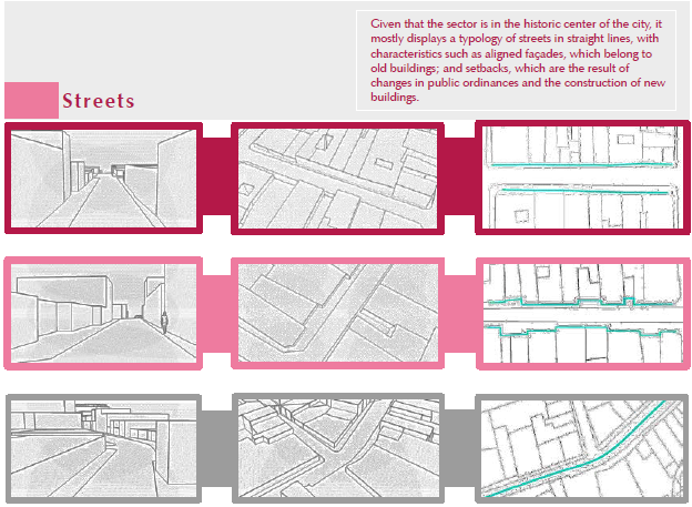
Source: Briceño, Gordon, Lobatón, Márquez & Peña (2015). ©
Figure 3 Analysis of physical-spatial configuration: Streets
The educational, religious, sociocultural, residential and service routes, together with nodes of encounter, are linked to pedestrian routes. In this sense, the micro-sequences identified in Figure 4 show the findings of the analysis and the possibilities they offer for conceptualization, since part of the treatment in the medium and short terms implies articulating the public space through sequences that give character to the landscape.
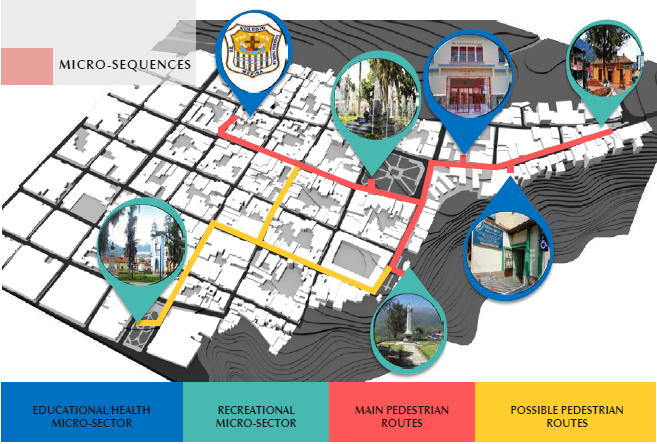
Source: Briceño, Gordon, Lobatón, Márquez & Peña (2015). © Copyright
Figure 4 Analysis of physical-spatial configuration: Micro-sequences
The activities attribute shows their type and proximity in relation to housing; economic interaction on the street, information activities and the presence of commercial premises, as well as the time invested in accessing them conform areas of proximity in the daily life of people; variables that reinforce the definition of micro-sectors that promote safe and highly vital spaces (Figure 4).
With regard to the diversity attribute, it is important to highlight the scarcity of green areas in relation to housing, which is why it is fundamental to gain recreational spaces and green surface per inhabitant. This effort should also be directed to different age groups (children, youth, adults, seniors) with different conditions, to meet their needs.
As for the biodiversity attribute, biotic, abiotic and connectivity elements have been analyzed. Regarding the first, vegetation coverage represents 20% compared to the built-up area; trees in open spaces are limited to two existing squares in the sector; the open area in the interior of blocks has little vegetation, which, however, can be recovered with medium- and long-term actions. There is no variation in the color of vegetation, which is scarce according to the climatic seasons of the year. As for the abiotic aspect, slopes are close to 12% in the north side of the urban space and less than 6% in the southeast. There are no elements that would offer protection for pedestrians from rain or sun. Regarding connectivity, little relation is observed between routes, natural spaces, and the concentration of people on streets (Figure 5).
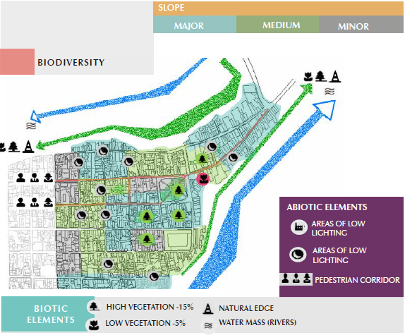
Source: Briceño, Gordon, Lobatón, Márquez & Peña (2015). ©
Figure 5 Analysis of biodiversity, biotic elements, and connectivity
The natural physical integrity attribute evidences the degree of natural conservation observed in temporal layers, and the maintenance and conservation of singular elements. Figure 6 shows the temporal layers, where 1 is the oldest and 2 is the most recent. The analysis highlights low visual or functional accessibility to these natural spaces and to scenic backgrounds.
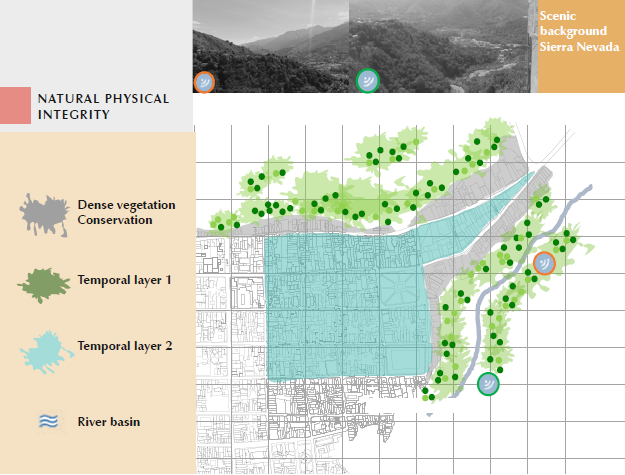
Source: Briceño, Gordon, Lobatón, Márquez & Peña (2015). ©
Figure 6 Analysis of natural physical integrity
The urban physical integrity attribute complements this study with an assessment of the strength of buildings, spaces, and elements recorded in the plan. Patrimonial buildings were identified using heritage catalogs; building strength is based on objective data shared in the workshop, which makes it easy to determine existing elements and their potentialities. This helps to reinforce landscape sequences later, in the design proposal.
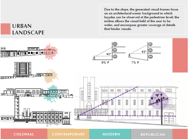
The aesthetic expression attribute is based on the identification of sectors that, due to the cohesion of their architectural typological characteristics, generate spatial units through visual patterns that, in relation to public spaces, highlight the historical character of the sector.
Scenic backgrounds, based on an identification of wide views and the degree of detail (furniture, signage, etc.), are analyzed not only through green spaces, but through built elements and their possibilities to emphasize wide views, or, on the contrary, to obstruct them.
In addition to assessing building height in relation to visuals towards scenic backgrounds (Figure 7), the study also identifies architectural typologies that complement the reading of historical layers in the sector’s urban landscape.The determined patterns-colonial, republican, modern, and contemporary-serve as a basis for the treatment of façades. This aspect offers an opportunity to differentiate micro-sequences and to characterize each of them, which has a positive effect on the reading and orientation of the sector.
The described attributes allow observing what happens in the city’s public space from the characteristics and qualities of its elements, to activities carried out by people. Form and function-perceived, analyzed, interpreted in ensembles and sequences-orient the structure of urban landscape, while identifying different concepts that are adapted, in turn, to the conditions derived from the needs of people.
Discussion: Public space and urban landscape design
Moving from analysis to project involves defining appropriate planning and design concepts in order to improve the visual quality of the urban micro-interface. The general intervention proposal for the sector evaluates appropriate concepts, actions or strategies, as well as specific design for perceptual patterns, defined according to visual sequences based on the attributes that are intended to be improved.
The structuring project for the Milla sector of the central area proposes an interesting concept (Figure 8) that reinforces its checkerboard grid, and seeks to reconfigure and grant greater vitality to the public space through perception and functional relationships. The authors of the proposal state:
The starting point is the idea of an intervention in the Milla sector with habitable vision, understanding that to inhabit a region is to feel, assume, and value the presence of the communities that live there. In this case, the structuring design is developed based on three items: moving: ideas to improve connections; living: ideas for rest, contemplation, and breathing; observing: ideas to differentiate places to be recognized, places to travel through, and places to coexist in them (Briceño, Gordon, Lobatón, Márquez & Peña, 2015).
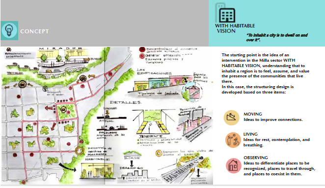
Effectively, the structuring of elements and sequences requires a vision that promotes exchange and the enjoyment of public spaces, where streets and places of permanence represent opportunities to establish new connections and possibilities to promote urban life. To perceive, interact, contemplate, protect, and orient are basic notions for the proposal (Figure 8). The identified purpose is related to artisanal activity, tourism, and recreation along its avenues 1 and 2; these converge in the cultural and recreational purpose of the sector.
Routes are proposed that connect the identified sequences with public spaces, as well as with the interiors of blocks. Green systems also contribute to reinforcing connectivity and to defining the identity of each micro-sector. The study proposes to create variation in vegetation cover using selected types with different colors for the interiors of blocks, which are going to be recovered in the medium and long terms.
The two visual sequences outlined in Figure 9 present design options for the existing and future city, introducing gradual interventions that seek to increase the visual quality of landscape in terms of urban aesthetics.
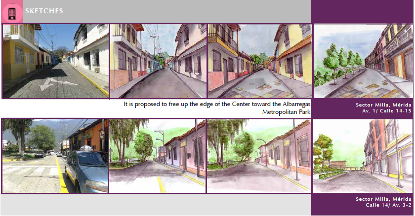
Source: Briceño, Gordon, Lobatón, Márquez & Peña (2015). ©
Figure 9 Micro-sequences: sequences visual
The treatment of façades proposed for the sector follows the guidelines of the typological patterns encountered. Diversity in architectural treatment is an important factor in preserving part of its identity as a whole. The mixture of architectural types in the definition of elements that generate visual cohesion is decisive for the orientation and characteristic beauty of the site. The idea is to recreate the concept of unity in architectural diversity.
Conclusions and recommendations
This attribute system provides a useful tool when preparing studies and comprehensive proposals regarding urban landscape. Implemented in the teaching of architecture, it fulfills the stated objective of including the study of context and the increasingly complex variables that affect it in order to make decisions in relation to architectural design.
The formulated hypothesis allows verifying that the study of urban landscape attributes result in a diagnosis oriented to the design of public spaces as an expression of daily life in the city of Mérida, with an increased visual quality.
Even when there is only limited time to carry out this type of exercises in a workshop, it is recommended to submit the elaborated proposals for public consideration in order to establish, based on preference studies, whether the sequences and the treatment of design satisfy or not the expectations and needs of different human groups.
The premise for moving from analysis to design is an interaction with the affected persons, not only to study the context in which they live, but also to show them different options regarding the changes they propose to introduce. Sometimes people know what they need, in other occasions, they do not. The proposal of novel ideas that are based on a deep knowledge of landscape attributes by those who intervene in the public space allows developing designs that reflect the adaption processes of human beings to their life environment.
Acknowledgements
The author wants to take the opportunity to thank students Vanessa Briceño, María Gordon, Elimar Lobatón, Ana Márquez, and Mariangel Peña. Their effort, dedication and maturity in carrying out the research has served as an excellent example to demonstrate the usefulness of including the study of urban landscape attributes in relation to public space in the teaching-learning process of the architectural design workshop, explained in this article.
Referencias
Arias-Romero, C.; Carreño-Novoa M.; Catumba-Rincón C.; Duque-Guevara O.; Manrique Castellanos C.; Mateus-Garcia S.; Pedraza Mora N.; Prieto Garzón F.; Torres-Bolivar S. (2016). Construcción de espacios comunes y colectivos: aportes conceptuales al territorio urbano. Bitácora 26(1). 9 - 22. doi: http://dx.doi.org/10.15446/bitacora.v26n1.58028. [ Links ]
Borja, J. (2002). La ciudad como oferta y la innovación urbanística . En: El Marketing como estrategia de desarrollo metropolitano. Curso para la Agencia transfronteriza para el desarrollo de la eurociudad vasca. San Sebastián: [ Links ]
Briceño, A M. (2009, julio- diciembre). El valor estético y ecológico del paisaje urbano y los asentamientos humanos sustentables. Revista Geográfica Venezolana - 50 (2), 213-233. Recuperado de: http://www.saber.ula.ve/handle/123456789/31006. [ Links ]
Briceño, A M.; Gómez, L. (2011, enero- junio). Proceso de diseño urbano-arquitectónico. Provincia, Revista venezolana de estudios territoriales. 25, 93-116. Recuperado de: http://www.redalyc.org/html/555/55519834006/. [ Links ]
Briceño, M; Owen de Contreras, M.; Contreras Miranda, W. (2011, enero-diciembre). Propuesta de un sistema de indicadores para evaluar la calidad visual del paisaje urbano. Revista Ecodiseño & Sostenibilidad. 3, 65-104. Recuperado de: http://erevistas.saber.ula.ve/index.php/ecodiseno/article/view/4371. [ Links ]
Briceño, A M.; Contreras M, W.; Owen de Contreras, M. (2012, enero- junio). Atributos eco-estéticos del paisaje urbano. Revista Luna Azul. 34, 26-49. Recuperado de: http://200.21.104.25/lunazul/downloads/Lunazul34_3.pdf. [ Links ]
Briceño V., Gordon M., Lobatón E., Márquez A. y Peña M. (2015). Con visión habitable. Trabajo de Taller de Diseño Arquitectónico 70, profesora Morella Briceño Avila. Trabajo inédito. Facultad de Arquitectura y Diseño, Universidad de Los Andes, Mérida Venezuela. [ Links ]
Cullen, G. (1974). El paisaje urbano: tratado de estética urbanística. Barcelona: Blume. [ Links ]
Chenoweth, R. y Gobster, P. (1990). The Nature and Ecology of Aesthetic Experiences in the Landscape. Landscape Journal. 9 (1): 1-9. DOI: http://dx.doi.org/10.3368/lj.9.1.1. [ Links ]
Gavrilidisa, A A.; Ciocănea, C M.; Niță, M R.; Onose, D. A.; Năstase, I. I. (2016). Urban Landscape Quality Index - planning tool for evaluating urban landscapes and improving the quality of life. International Conference - Environment at a Crossroads: SMART approaches for a sustainable future. Procedia Environmental Sciences 32, 155 - 167. doi: http://dx.doi.org/10.1016/j.proenv.2016.03.020. [ Links ]
Gehl, J. (2005). Public spaces - public life -in the 21st century. Founding Partner: Gehl Architects. Copenhagen: Urban quality consultants. Recuperado de: https://urbandesignaustralia.com.au/images/Docs/Papers/Jan_Gehlgold_PublicSpaces_life.pdf. [ Links ]
Gehl, J.; Gemzøe, L.; Kirknæs S.; Sternhagen S., B. (2006). New City Life. Copenhagen: Arkitektens Forlag - The Danish Architectural Press. [ Links ]
Google Maps, (2017). Mérida Venezuela. Recuperado: de https://www.google.es/maps/place/. [ Links ]
Jalaladdini, S y Oktay, D (2012). Urban Public Spaces and Vitality: A Socio-Spatial Analysis in the Streets of Cypriot Towns. Procedia - Social and Behavioral Sciences 35, 664 - 674. DOI: https://doi.org/10.1016/j.sbspro.2012.02.135. [ Links ]
Lynch, K. (1992). La administración del paisaje. Bogotá: Norma. [ Links ]
Maimunah R., Dasimah O., Rozyah M. Y. y Zalina S. (2015). Revitalization of Urban Public Spaces: An overview. Procedia - Social and Behavioral Sciences 201. 360 - 367 DOI: https://doi.org/10.1016/j.sbspro.2015.08.187. [ Links ]
Matsuoka, R H. y Kaplan, R. (2008). People needs in the urban landscape: Analysis of Landscape and Urban Planning contributions. Landscape and Urban Planning. 84: 7-19. DOI: https://doi.org/10.1016/j.landurbplan.2007.09.009. [ Links ]
McHarg, I. (2000). Proyectar con la naturaleza. Barcelona: Gustavo Gili. [ Links ]
Nassauer, J.I. (2012). Landscape as medium and method for synthesis in urban ecological design. Landscape and Urban Planning 106: 221- 229. DOI: https://doi.org/10.1016/j.landurbplan.2012.03.014. [ Links ]
Rapoport, A. (1974). Aspectos de la Calidad del Entorno. Cataluña: Colegio Oficial de Arquitectos de Cataluña y Baleares. [ Links ]
Rodríguez, G. F. (2005). Medio ambiente, desarrollo y paisaje en las sociedades postindustriales. Usos, valores, alianzas y conflictos. Madrid: Universidad Complutense. Recuperado de: http://eprints.ucm.es/tesis/19972000/S/1/S1036801.pdf. [ Links ]
Russell, J. A. (1980). The circumplex model of affect. Journal of Personality and Social Psychology, 39 (6), 1161-1178.DOI: http://dx.doi.org/10.1037/h0077714. [ Links ]
Segovia, O y Jordán, R. (2005). Espacios públicos urbanos, pobreza y construcción social. Nº 122. Serie medio ambiente y desarrollo. CEPAL. Chile. Recuperado: https://repositorio.cepal.org/handle/11362/5660. [ Links ]
Sevilla-Buitrago, Á. (2014). Central Park y la producción del espacio público: el uso de la ciudad y la regulación del comportamiento urbano en la historia. Revista EURE - Revista de estudios urbano regionales, 40 (121) 55-74. Recuperado de: http://www.eure.cl/index.php/eure/article/view/541. [ Links ]
Received: September 18, 2017; Revised: May 27, 2018; Accepted: July 30, 2018
 Este es un artículo publicado en acceso abierto bajo una licencia Creative Commons
