


 text in
  English (pdf)
 Article in xml format
 Article references
 Send this article by e-mail
 Cited by SciELO
  Cited by Google
  Similars in
SciELO
Similars in
SciELO  Similars in Google
 Permalink
Introduction
This article is the result of the institutional project, "Walking as a city learning experience," financed by the Research Center of the National Pedagogical University during 20181. The objectives of this project were to identify the conceptual structure through which participants assess the physical and social conditions that make possible the experience of apprehending the city walking; determine the purposes of individuals when they walk, and gather the experience acquired in the places through which individuals pass. Based on this exploration, the project formulated management recommendations for urban education and normative guidelines that contribute to the walkability of the city within the context of the educator city.
The article begins by reviewing some scientific works that investigate walking from the perspective of health studies, pedestrian safety, gender, and urban management. Next, it justifies the need to add to the indicators that have been developed, the exploration of the subjective evaluations people makes regarding how walkable the city is. Accordingly, the article analyzes the results of the application of a questionnaire to collect the assessments Bogota residents make regarding the walkability of the city, and analyzes their answers through statistical techniques of multi-dimensional scalability.
Urban walking
Walking tends to be presented as a motor activity that contributes to maintain one's physical state and improve health conditions. In addition to contributing to sustainable mobility, walking in the city promotes social, recreational, and consumption encounters through which one acquires a cultural experience of appropriation of the urban environment. This article analyzes walking based on the identification of the purposes of individuals when they move by foot through different spaces and their perceptions regarding the physical and social conditions that facilitate or hinder the walkability of a city, in this case Bogota.
The majority of research on walking focus-es on its importance for health. People who work are less prone to obesity (Bassett, Pucher, Buehler, Thompson & Crouter 2008; Haines et al., 2009) and walking is broadly recommended as part of a rehabilitation process for various types of health problems (Forjuoh et al., 2017; Keller & Cantue, 2008). Studies recognize the importance of out-door recreation in urban spaces, where walking through one's neighborhood should be considered a recreational activity within the framework of urban recreation (Lee & Ingold, 2006; Le Breton, 2007; Keller & Cantue, 2008). With respect to safety, statistics show pedestrian accidents are one of the main causes of morbidity and mortality in Colombia. In 2017, Forensic Medicine's report included 7,936 cases of pedestrian accidents, of which 1,790 were fatal (Forensic Medicine and Science Institute, 2017, p. 389).
Spatial design and gender studies deserve special attention for the purposes of this article. With respect to spatial characteristics and their influence on behavior, research into the psycho-spatial dimension highlights the effects of the dis-appearance of spaces for social gathering, which were located in the streets and plazas, on social dynamics of gathering and recreation (Páramo & Cuervo, 2009; 2013). As Jacobs (1961) stated, sidewalks and corners were important places for social transactions in the city, informal gatherings of adults, children's play, and adolescent gatherings. These activities have been replaced by window shopping in malls or gatherings in socio-places, both of which are mediated by consumption (Páramo, 2011).
Similarly, in exploring the physical and social barriers one faces walking, Hollenstein et al. (2016) highlights the presence of sidewalks, crosswalks, and speed limits for vehicles as conditions one considers in deciding whether to walk to a place. And D'Álessandro, Appolloni & Capasso (2016) add more subjective aspects to this decision, such as the perception of safety and urbanity of city residents. According to environmental studies, the benefits of walking or riding a bike include greater social inclusion, higher air quality, and less traffic (Haines et al., 2009).
Kerr et al. (2016) identifies some situations people identify as necessary in order to move through a neighborhood and city by foot or bicycle. Walking is mainly associated with the perception of residential density; street connectivity; access to shopping centers, recreational spaces, and bus stops; the aesthetic of the spaces through which one walks; safety, and perceived distance to one's destination. From a technical perspective, urban management studies tend to propose objective indicators and indices regarding how walkable cities are (Talavera & Soria, 2015; Tribby, Miller, Brown, Werner & Smith, 2016; D'Alessandro, Appolloni & Capasso, 2016; Gutiérrez, Caballero & Escamilla, 2019).
With respect to issues of gender, for women, it has been shown that walking is not only risky, but also limited by the spatial design and symbolic barriers that condition access to public spaces (Burbano, 2016; Lindón, 2006). Restricting transit, in particular by foot, generates negative effects on women's urban social life, including abandonment or withdrawal from public space and the establishment of actions to be able to participate in urban social life (Falú, 2009). According to Ortiz-Cuitart (2007), women seek to avoid being assaulted, robbed, harassed or victims of sexual violence when present in public space. Restrictions to walking have led women to naturalize mobility routines with the purpose of avoiding risks and to opt for taking familiar roads, modifying travel routes and schedules (Siqueira, 2015). In other cases, it results in women with-drawing to the home, or making use of surveil-lance or defense technologies (Burbano, 2014; 2015). With studies like these, the geography of gender demonstrates it is not safe to circulate freely through public spaces, given the invasion of their privacy reflected in non-consensual physical contact or physical or verbal violence. This is consistent with the ways in which urban public space has been managed from a masculine vision.
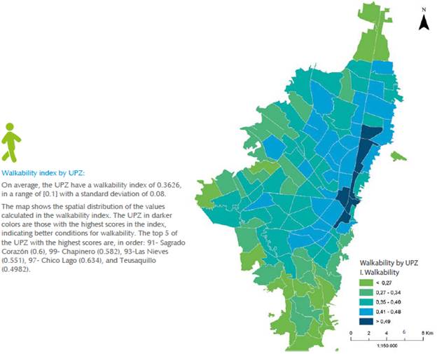
Bogota has made important efforts in pro-viding the city with bike lanes and sidewalks to make the city walkable (Figure 1), creating norms and programs to promote walking and protect pedestrians, such as the campaign "Look at yourself, we're all pedestrians" and the road safety policy "Vision zero" to counteract the situation of the pedestrian as the most vulnerable actor on the road. Recently, Bogota was the headquarters of the 2018 Walk21 international conference.
Even when there is extensive literature regarding walking in urban environments, and objective indicators to establish how walkable cities are have been proposed, exploring subjective assessments is indispensable. On this topic, little is known about how walkable a city is for its residents, their motivations for walking, the difficulties they face in pursuing these motivations, and if the experience varies depending on the place one walks.
Metodology
Design. Correlational descriptive study, based on the characterization of an experience gathered through affirmations that compose a questionnaire, whose answers are systematized using a statistic program that visualizes the level of statistical correlation between the Items. The design follows the same methodological guidelines that have guided other works of the authors (Páramo & Burbano, 2013; Páramo et al., 2018).
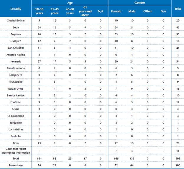
Participants. 305 men and women from diverse age groups and residents of various city localities participated voluntarily. An intentional non-probabilistic sampling strategy was used. The simple was stratified according to four age ranges, from 18 to 75 years. Fifty-two percent of participants identified as women (n = 166), and 44 percent as men (n = 139). None of the participants identified as "other" for their gender, although the questionnaire included this option. Table 1 presents the distribution of the sample according to the number of questionnaires collected and the age range and gender the participants provided.
Table 1. Distribution of the sample in Bogotá, according to age and gender.
Source: author elaboration, 2018.
Instruments. Researchers developed an ad hoc instrument comprised of 49 items that evaluate the city's walkability based on three dimensions: the purpose of the person walking, the place through which he or she walks, and the socio-spatial conditions that facilitate or hamper walking, with a scale of seven points: from very unwalkable (1) to very walkable (7). Only women responded to item 49, as it asked about harassment while walking. An additional scale (item 50) asked about the general walkability of the city, which is why this item was treated differently. The option "don't know" was included for cases in which the situation to be evaluated did not apply from the point of view of the participant. The items included were the result of a literature review regarding the conditions that make urban public space walkable and were built such that each one includes an aspect of each dimension to be explored (purpose, place, socio-spatial conditions), following the Facets Theory model (Borg & Shye, 1995; Hackett, 2014). At the end, the instrument asked about the socio-demographic conditions of the participant, his or her age, gender, and locality of residence. Three independent judges validated the questionnaire, which was also validated through a pilot study with 60 participants. The Cronbach's Alfa test was used to analyze the instrument's internal consistency (Cronbach alpha = 0.946).
Procedure. The instrument was applied virtually. Participants granted informed consent at the beginning of information collection, and were ensured the information provided would be completely anonymous and voluntary. The information was collected during the months of April and May 2018.
Results
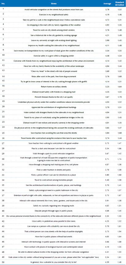
In order to compare participants' assessments regarding the walkability of the city, researchers obtained the values of statistical average and standard deviation for each item (Table 2).
Table 2. Average and standard deviation of items ordered based on the average, result of study participants’ assessments.
Source: author elaborated, 2018.
Information analysis through multidimensional scaling
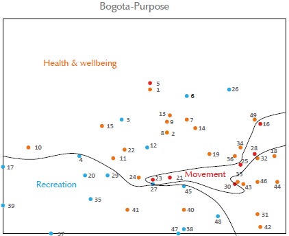
In order to explore whether the participants conceptually structure their assessment of the conditions associated with the city's walkability based on the proposed dimensions, the answers to the various Items were examined through Smallest Space Analysis (SSA) (Borg & Croenen, 2005), using the HUDAP® statistical package. SSA correlates the Items following the specifications of the Pearson's coefficient,2 which allows one to visualize the degree of correlation between Items based on the spatial closeness between the various Items. The program outputs three different planes, one for each dimension to which the item refers. As you will recall, each item was designed to address three dimensions (purposes, place where one walks, and socio-spatial conditions). The correlations between these items resulting from the SSA analysis allow one to note significant regions in the respective planes or figures for each of the dimensions explored in the questionnaire.
Purposes
Figure 2 shows the spatial distribution of items according to the degree of correlation between them based on the dimension "purposes of walking." One may observe these are grouped into three regions. The first, denominated recreation, groups together items that refer to this activity. Thus, for example, in this region we find items 4) go shopping in the mall with my family; 17) distract myself safely with friends in a shop-ping mall; 48) be able to attend cultural events in the shopping center, far from vehicular congestion, which have the highest averages. The second region, in the upper section of the graph, groups mainly items that refer to health and well-ness, although some could form part of recreation. The following items stand out: 8) improve my health walking the sidewalks of my neighborhood; 10) exercise safely in a gym inside a shopping center; 19) do physical activity under the weather conditions provided by natural environments, which are the items with the highest averages of this region. And items 32) finding a water fountain in streets and parks; 36) satisfy a physiological need in a public bathroom in the city; and 49) walk alone in the city center without being harassed (Figure 2).
Place where one walks
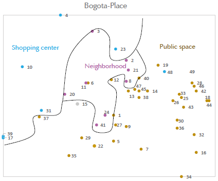
By identifying the items within the dimension "place where one walks," the plane the SSA program output could be divided into three clearly differentiated regions (Figure 3). The first region, denominated shopping center, joins the items that refer to the experience of walking in these types of places. The following items stand out with high averages: 4) shopping in a shopping center with my family independent of the weather; 10) exercise safely in a gym within a shopping center; and 17) distract myself safely with friends in a shopping center. In the central region of the graphic are the items that refer to one's neighborhood. Here only item 8) improve my health walking along the sidewalks of my neighborhood, stands out, with a high average. Finally, in the lower right part of the graph are grouped the items that refer to walking through public spaces, whether natural or manmade. Item 19) undertake physical activity under the weather conditions provided by natural environments, is the item that stands out, having a high average value. It is important to note the items related to shopping centers are spatially opposite to those that refer to open public spaces, which denotes negative correlations between them. Thus, one may suppose the participants consider the experience of these places to be opposite, very likely attributable to the perceived conditions of safety, enclosure, and diversity of stimulation. The items with the lowest average in the region of public space are: 16) return home on solitary streets; 32) find a water fountain in streets and parks; 35) satisfy a physiological need in a public bathroom in the city; and 49) walk alone in the city center without being harassed.
Socio-spatial conditions that facilitate or impede walking
In figure 4 the items are differentiated based on the dimension "physical and social conditions," and are grouped into three regions. The first region, located in the upper left side of the figure, denominated "physical," does not include items that stand out with high averages. Item 16) return home on solitary streets, has the lowest average of this region. The upper right side of the figure includes the items related to intangible and social conditions that favor walking, where items 6, 8, 10, and 15 stand out with high averages. The lower left side of the figure groups those items that facilitate walking, in which, item 48 stands out due to its high average.
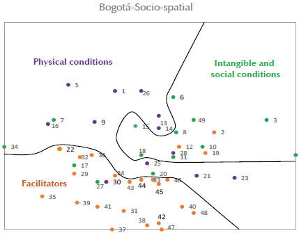
One may observe an opposition, or weak correlation, between the items that form part of the region "facilitators" with those of "social conditions," which reflects the differences between the role of the physical environment and that of social elements associated with walking. The items with the lowest average in the region of facilitators are 32 and 36.
Finally, with respect to the perception of harassment women face when walking in public spaces (item 49), the average of the 166 female participants was 3.34 for this item, which indicates women feel harassed when they move through Bogota walking. This puts them at a disadvantage to men and limits their experience of appropriation of the city. In evaluating the level of walkability of the city in general (item 50), the average was 4,39, which indicates the city is moderately walkable for study participants.
Discussion and conclusions
The study identified three main reasons why people walk: to travel to one's place of work, study, or to undertake personal errands; leisure or recreation; and for health and wellbeing. It also found the participants differentiate the experience of walking into three types of spaces: shopping centers, one's neighborhood, and public spaces (natural and manmade). Finally, the study identified physical and social conditions of walking: physical conditions, social and intangible conditions, and facilitators.
The most highly valued items are those that affirm the city is walkable in shopping centers and to walk dogs; pets seem to be important facilitators in people's health. Similarly, the participants considered the natural elements of the city as favorable to walking. The least favorably evaluated items are related to security, the harassment women experience, and the lack of urban furnishings, such as water fountains and public bathrooms.
Thus, walking is more than a motor experience: it is social, recreational, phenomenological, and emotional, which is why cities should not be designed only to be seen, but also to be lived and inhabited. Making cities walkable can be an important step that leads to reaching this goal. Thus, making a city walkable is the best option to integrate oneself into the city and society, to improve one's health, undertake recreation, and acquire a significant experience through accessing and culturally appropriating the city.
In identifying the reasons that motivate people to walk, and the spatial and social conditions that facilitate or impede it, an important contribution is made to improve the quality of urban life. Without a doubt, walking may be an enriching experience regarding learning and in terms of social involvement, recreation, and physical and mental health.
The findings of this study are consistent with the research reviewed in the introduction of this article, in that it also determined that to make cities walkable they need to be safer, with improved infrastructure, a greater number of walkable kilo-meters at a small scale, and include landscape elements, both natural and of architectural aesthetic. But physical infrastructure is insufficient, and it is important to design school and health and sport programs to promote walking.
Although we are all pedestrians, there are not clear and sufficient policies that take into account this condition, which indirectly affects people's health and directly affects them when it involves security. Thus, it is important to have indexes and objective and subjective indicators that allow for follow-up of public policies and different programs carried out from urban planning and management.
Bogota and the country should create and adopt objective indicators, such as those Gutiérrez, Caballero & Escamilla (2019) propose, which include environmental quality, population density, proximity or distance to areas of interest, the physical conditions of areas where people walk and their diversity of uses. They should also adopt subjective indicators such as those mentioned here, which allow for follow up of public policies that affect walking.
It is essential to make the city safer through urban design, enforcing the police code, and educating residents so women in particular feel safe when they walk through public spaces.
Although measurements using objective indicators regarding the physical environment are important, the evaluations residents make regarding their experience of walking, through subjective indicators, provide valuable information such that they respond to the needs perceived by the population. Aspects such as the perception of safety, aesthetic, socialization, and phenomenological experiences of walking cannot be measured objectively, but they do play an important role in what citizens want to improve their quality of life in the city. Such data is necessary to diagnose problems, design strategies to solve them, and evaluate their impacts.
For future research, and due to the heterogeneity of the territory, it is necessary to continue the line of research of walkability starting with the neighborhood, locality and age group of individuals, which will require a sample that is stratified by neighborhood, locality, and age group, as important differences may be observed that this study did not explore, given the way the questionnaire was applied. Additionally, it is important to research the subjective experience of walking through narratives, in particular and more in depth, regarding the evaluations women make when they walk through the city.

