


 Inglês (pdf)
 Artigo em XML
 Referências do artigo
 Enviar este artigo por email
 Citado por SciELO
  Citado por Google
  Similares em
SciELO
Similares em
SciELO  Similares em Google
 Permalink
INTRODUCTION
According to the World Health Organization (WHO), the worldwide mortality burden associated with environmental conditions is 23 %. In developing countries, this rate rises up to 25% [1] . Among the diseases with the highest mortality are diarrhea attributable to the environment (94%), respiratory infections (41%) and malaria (42%). Likewise, the environmental factors with most significant impact on human health are the inadequate sanitation and the poor quality of water. In 2000, 1.1 million people (18%) lacked an adequate water supply, and 2.4 million (40%) were left without water supply service [2]. In Colombia, it is estimated that disease burden due to environmental conditions is 17 % (46,000 deaths per year). This situation is partly due to inequity in the access to public services, low incomes and excessive growth of the industrial sector. These factors increase the levels of vulnerability and exposure of the population [3].
The environmental factors that contribute most to premature deaths in Colombia are air and water pollution, and poor hygiene practices. According to the environmental analysis by the World Bank, the low quality of air and water and the inappropriate use of chemical substances (chemical safety) have high impact on the Colombian economy [4]. In Colombia the effects of the environment on health represent approximately 1.1 % of the gross domestic product (GDP). From these percentages, nearly 70 % (0.77 % of GDP) is attributable to mortality and morbidity, and 30% is attributable to prevention costs (consumption of bottled water, domestic water filtering and domestic boiling for purification) [3]. In some regions in Colombia like Timbío (Cauca), gastrointestinal diseases, diarrhea, and gastritis are the first causes of medical consultation Moreover, Timbío is a municipality with a high prevalence of pathogens such as Helicobacter pylori (65 %). This pathogen, in turn, is associated with gastric cancer, which is the first cause of death by cancer in the Cauca department .
Despite the efforts in Colombia for developing health policy that includes the environmental dimension, greater efforts are still required to coordinate the actions of the different actors. For this reason, few programs and initiatives on environmental health can be found at the national and regional level. In this scenario, the production, collection, management, analysis and dissemination of environmental health data is deficient due to: i) a lack of compatible information systems within and between these sectors (health and environment); ii) insufficient use and analysis of information at the national level; iii) inadequate human resources and technology for information management; iv) a lack of an integrated system for decision making on environmental health, and; v) a poor articulation with the private sector to integrate data [3]. Thus, few studies combining environment and health can be found. Conversely, most of the proposed approaches are focused on health or environment, separately. Additionally, few studies on environmental health have described the subjacent technological infrastructure.
In order to offer a solution to this problem, a University-Enterprise alliance has been created with funding from the Colombian Government. This coalition aimed at building a Services Platform for Environmental Health (PSAM for its initials in Spanish). The platform incorporates a Geographic Information System (GIS) and a data-mining module for the comprehensive management of the information that supports decision-making. Besides, the platform aims at promoting actions to prevent health risks. This article describes the design and progress achieved in the implementation of this service Platform. PSAM integrates four main modules: i) a data collection module (P-Mobile); ii) a module that integrates diverse data sources and supports the visualization of the collected information (Massa); iii) a module for prediction of H. Pylori (MMDG); and iv) a module for community empowerment (MebTIC).
1. RELATED WORKS
Some frameworks and architectures have been proposed for analyzing the impact of the environment on human health. In [5], a user-centered design of a participatory framework is described. The framework supports environmental decision-making based on environmental information. The data visualization supports the decision-making in diverse contexts together with the community and is validated with a community in Peru. In [6], the integration of geospatial information for the development of an environmental health information management system in Asia is described. This architecture integrates health and environment with the government participation as a coordinator. The system promotes public participation as a means to validate and give feedback about the system. In [7], it is highlighted that the biggest challenge for this type of systems is integrating heterogeneous and incomplete data sources. The modeling of these data is challenging, among other factors, to the diversity of techniques for data collection. A high-level interoperable system for Europe is proposed. The proposed system integrates diverse environmental data based on Geographic Information Systems (GIS). The system is validated in a case study of air pollution in London.
The project “Enhis- Implementation of the information system on the environment and health in Europe” [8], was developed by the European Center for Environment and Health of the WHO and other entities from eleven countries. The objective of the project is to develop an information system that allows monitoring and evaluating environmental risks for children0’s health and development. The first prototypes include the evaluation of air and water quality based on international indicators, and the dissemination of this information through a website that informs area residents about health risks.
In [9] an information system on environmental health for public health services is proposed. The system aims at solving the deficiencies in the infrastructure to manage environmental health information. A platform based on web technologies integrates databases, decision-making tools, and GIS. In Mexico a solution for environmental monitoring based on the integration of Neural Networks and sensors was developed [10]. A mobile system was developed to identify environmental contaminants. Equally, a low-cost data acquisition system based on Arduino automatically classified pollutants present in the air through neural networks. In [11] a review of technologies and architectures for the acquisition, analysis, and deployment of health environment systems is presented. The proposed system integrates semantic web, three-dimensional visualization of data, real-time monitoring and citizen information.
In Colombia, some efforts have been made to generate models or policies for the assessment of environmental health [12]. However, the development of environmental health in Colombia is at an early stage and most of the efforts come from universities. In some cities, environmental health represents a big issue. For example, Medellin has been forced to declare an alert emergency twice in the last decade. To address this issue, a website has been set up to promote interest in the environment. This site publishes environmental reports continuously. On the other hand, the National Technical Commission for Environmental Health (Conasa for its initials in Spanish) is working on the articulation of institutions to create the National Environmental Health System. Conasa is currently working on the initial phases of the design of a Unified System of Information on Environmental Health (Suisa).
From this review, some elements can be concluded. Firstly, environmental systems must integrate diverse, heterogeneous data sources. This is because these sources come from different organizations or divisions with particular collection methods and database models. Secondly, most of the systems integrate GIS for data displaying. Finally, significant efforts to incorporate the community’s viewpoints into these platforms have been made.
Despite the efforts achieved so far, there are still gaps and obstacles. Firstly, most of the published works do not describe the design process of systems. Only the work exposed in [5] describes the design from a polycentric perspective. However, this system is focused exclusively on the environmental field. The present paper describes the design process, including diverse actors from the environmental health ecosystem. Secondly, most of the systems enable users to visualize data but provide few or no tools for prediction or further analysis. The present paper includes a model to predict the risk of H. pylori using decision trees, based on the existing epidemiological information. Thirdly, although in most of the published works community participation is highlighted, only a few propose tools for enabling communication with the people. Conversely, PSAM includes a component for managing communication through Short Message Service (SMS). Finally, most of the existing works are based on proprietary software that can be costly for some countries or institutions. The proposed platform uses free tools such as Javascript, Java and other free APIS.
As a first step, a multidisciplinary team was created. The team consisted of experts in epidemiology, biology, GIS, computer and environmental sciences. The team members came from InnovaGen Foundation and the Fundación Universitaria de Popayán. The objective of the project was to develop a platform to analyze the relationship between water quality and the appearance of H. pylori and gastric cancer in the municipality of Timbío, Cauca, Colombia. The community of the city of Timbío was selected since it is one of the municipalities with the highest prevalence of Helicobacter pylori infection (65 %).
The platform development was led by researchers from the Intelligent Management Systems Group of the Fundación Universitaria de Popayán and the InnovaGen Foundation. Several requirements should be considered during for the development of the platform. These requirements could come from various organizations.
Firstly, the main actors of the system were identified to carry out the requirements elicitation. Weekly meetings were held with these actors to know their expectations and socialize step by step the progress of the prototypes. The primary needs are described below:
Firstly, Secretary of Health of the Department of Cauca: This government office was mainly interested in obtaining a tool for the visualization of health data. This visualization would be useful for decision making when preparing/implementing health action plans. Thus, if a health risk can be early identified, action plans can be better focused. Besides, this office was interested in the empowerment of the community on environmental health issues.
Secondly, Regional Autonomous Corporation of Cauca: This organization was interested in the visualization of water quality. This information is essential for granting environmental permits.
Finally, the community of Timbío: The primary concern for the people was to know the quality of the water they were consuming. Also, the community was interested in meeting the government requirements to build/manage potable water systems in their territories. To achieve this objective, it was necessary to organize all water quality data and health and hygiene conditions. The community member’s expertise on IT tools is low; therefore, the functions for these users must be as useful as possible.
During these meetings, the data required to build the data warehouse that allows studying the relationship between water quality and H. pylori were identified. The needed information was related to household hygiene, water quality and perception of the community. To address this need, the first module of the platform was called P-Mobile and was devoted to collect information in the field through surveys. As the polls may vary, the system allows creating different types of questions, possible answers, and campaigns. Some tools can be found for this purpose such as surveyguizmo [13] and surveysparrow [14]. However, due to data privacy and to integrate the results of the surveys to the whole platform, it was necessary to develop a new module in the platform.
Secondly, an interface based on GIS to display the environmental health information was developed. This component of the platform was called Massa (for its initials in Spanish). This interface enabled users to perform the following functions:
Display the quality of water in different water sources.
Basic navigation functions: zoom in and out, layer management (roads, political division, households, water sources, rivers)
Group variables and layers by individual, household and community levels
Generate graphical reports of several variables (household conditions, individual diseases, community environmental conditions) vs. time. The socio-demographic data came from government entities (E.g., Colombian National Administrative Department of Statistics, DANE),
Thirdly, with the collected data, the possibility of estimating of having H. pylori infection probability was envisaged. Thus, the MMDG component estimates a percentage probability of this pathogen’s appearance. This estimation is performed based on a set of variables.
Finally, to carry out community empowerment on environmental health, the need of a component for sending customized messages to diverse groups in the community was identified. These groups can be created based on age, residence area or risk.
2. ARCHITECTURE OF PSAM
Figure 1 shows the components of PSAM. Each of the components are described below.
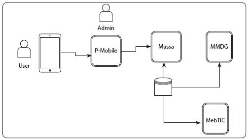
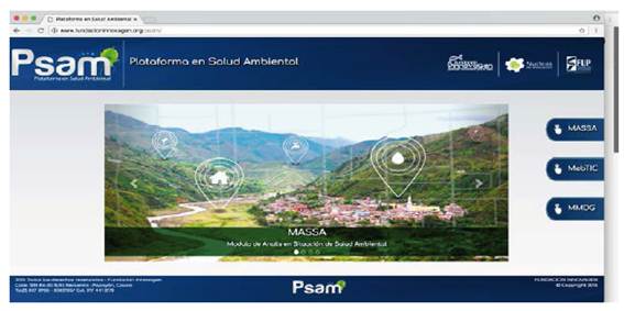
The prototype was developed using tools such as HTML, Javascript, MySQL and Java; also with some Open Layers and PostGis for Maps Display. None of these tools require license for the prototype implementation. The prototype is available for private use (see figure 2).
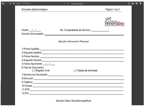
P-Mobile offers the possibility of managing surveys and allows creating new questions and possible answers. Surveys are designed by an administrator and can be answered from a mobile device. With P-Mobile, surveys can be configured and downloaded to mobile devices in order to collect data in the selected field. Also, the survey can be printed to be collected manually (figure 3). The collected information is synchronized with the database. P-Mobile Client was developed using Java Android, and the Web administration page was developed using Java Spring.
The Module of Analysis of the Situation in Environmental Health (Massa for its initials in Spanish) is responsible for displaying information for decision making. As mentioned before, this module is based on GIS. Nowadays, given the robust analytical tools used by GIS, it is possible to comprehensively address the environmental health problem, including the dimensions of the epidemiological triad: person (community) - etiological agent (exposure) - environment (location) effectively. Besides, this system includes users as a source of information to study water contamination. This tool will allow local knowledge to collect environmental and community variables. The prototype of this module was developed using JQuery, HTML, Open layers and Google Maps.
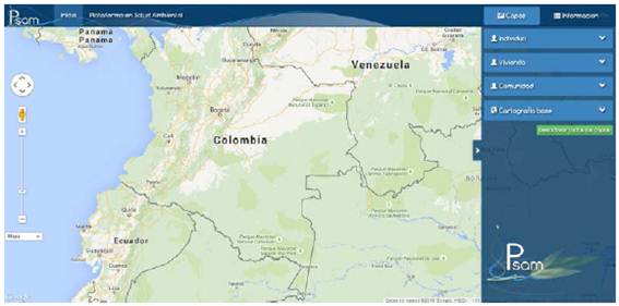
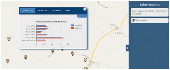
Massa allows the storage of geographic information on environmental, social and exposure variables, obtained through participatory diagnosis with the population under study. In the interface, layers can be activated/deactivated by clicking in the checkbox next to the layer’s name. These layers are grouped by dimensions: individual, household, community and base cartography (see figure 4). Additionally, some reports can be displayed. For example, figure 5 shows population distribution.
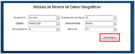
The Geographical Data Mining Module (MMDG for its initials in spanish) uses a model that allows estimating or predicting the appearance of H. pylori with an estimated precision of 68 %. This model was created using data obtained from the community of the municipality of Timbío. The prediction model was built using decision trees J48 implementation of Weka [15]. The selected attributes were: name of the aqueduct, social stratum (high, medium, medium-low, low), basic sanitation (yes/no), water treatment (yes/no), overcrowded home (high, medium, low), pet (yes/no). The graphic interface of the module is shown in figure 6. This Graphical User Interface (GUI) was developed using Java Server Faces and PostgreSQL.
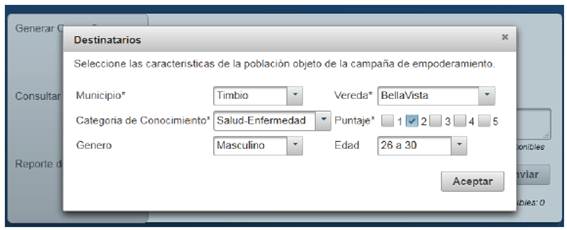
The Empowerment Module based on Information and Communication Technologies (MEbTIC for its initials in Spanish) promotes positive processes for behavioral change on hygiene, nutrition and good water management practices (such as boiling the water or washing hands). This module allows selecting a geographical area, gender, and age for the messages’ receivers (figure 7). SMS was chosen because this is the most commonly used service by farmers. This module enables the administrator to customize the messages and see the summary of the empowerment campaigns. This module was built using Java Server Faces and PostgreSQL.
3. CONCLUSIONS
Some efforts have been made to create platforms for managing and analyzing information on environmental health. However, most of these platforms have been designed from the point of view of one part or institution. Besides, these approaches are based on proprietary tools and do not integrate all the components needed to develop environmental health. Here, a platform for the analysis of environmental health based on open source tools is described. During the design process, three principal components were identified. The first was data gathering, for which an application called P-Mobile was developed. This component allows customizing surveys and collecting information. The second component developed was Massa, a tool for management and analysis of information based on geographic information systems. The third component, MMDG, uses the information collected to predict the appearance of H. pylori. Finally, MebTIC component was developed for sending SMS to different leaders in the community.
The proposed architecture can serve as a basis for other implementations in the area and can be extended to include data from other diseases or environmental variables. From the development of the platform, it was evidenced that one of the most important elements in these platforms is the visualization of information. In the proposed platform, the visualization was based on GIS to show the reports needed by users. In this regard, it is important also to consider the participation of diverse actors during the design to achieve a useful tool.
Future work may be to integrate the prediction module into maps that allow displaying risk zones. With this information, prevention campaigns can be focused on high-risk household or endemic areas. Equally, a usability evaluation is being planned with the farmers in order to improve the functionalities of the platform.

