


Services on Demand
Journal
Article
 Spanish (pdf)
 Article in xml format
 Article references
 Send this article by e-mail
Indicators
-
 Cited by SciELO
 -
 Access statistics
Related links
-
 Cited by Google
 -
 Similars in
SciELO
Similars in
SciELO -
 Similars in Google
Share

 Permalink
Revista EIA
Print version ISSN 1794-1237On-line version ISSN 2463-0950
Rev.EIA.Esc.Ing.Antioq no.14 Envigado July/Dec. 2010
INDO-PACIFIC AND TROPICAL ATLANTIC EOF MODES: CONTRIBUTIONS TO THE ANALYSES OF CLOUD COVER CONDITIONS IN THE LOS NEVADOS NATURAL PARK
FUNCIONES ORTOGONALES EMPÍRICAS (EOF) APLICADAS A LAS CUENCAS OCEÁNICAS TROPICALES INDO-PACÍFICA Y ATLÁNTICA: CONTRIBUCIONES AL ANÁLISIS DE LAS CONDICIONES DE COBERTURA DE NUBES EN EL PARQUE NACIONAL NATURAL LOS NEVADOS
FUNÇÕES ORTOGONAIS EMPÍRICAS (EOF) APLICADAS ÀS BACIAS OCEÂNICAS TROPICAIS INDO-PACÍFICA E ATLÂNTICA: CONTRIBUIÇÕES PARA A ANÁLISE DAS CONDIÇÕES DA COBERTURA DE NUVENS NO PARQUE NACIONAL NATURAL LOS NEVADOS
DANIEL RUIZ CARRASCAL*
* Ingeniero Civil y Magíster en Aprovechamiento de Recursos Hidráulicos, Universidad Nacional de Colombia Sede Medellín; M.A. in Climate and Society and Ph.D (c) in Earth and Environmental Sciences, Columbia University. International Research Institute for Climate and Society, Lamont-Doherty Earth Observatory, Columbia University in the City of New York. Grupo de Investigación Gestión del Ambiente para el Bienestar Social (Gabis), Escuela de Ingeniería de Antioquia. Medellín, Colombia. pfcarlos@eia.edu.co
Artículo recibido 3-IX-2009. Aprobado 17-IX-2010
Discusión abierta hasta junio de 2011
ABSTRACT
Colombian paramos are experiencing an increase in their climatic stress. One of the key factors behind is the change in cloud cover conditions, which are dependent on both regional and local processes. This work aims to explore the degree of association between the year-to-year variability of sea surface temperatures (SSTs) observed in the tropical Indo-Pacific and Atlantic oceans, and the year-to-year changes in regional cloud cover conditions prevailing over the Colombian Central Cordillera, but focusing on the satellite grid pixel where Ruiz-Tolima Volcanic Massif, the Los Nevados Natural Park and their surroundings are located. Analyzed records include mean monthly SSTs observed in the El Niño 3.4 region of the equatorial Pacific, SST anomalies observed in the tropical Indo-Pacific and Atlantic basins, as well as all-type cloud cover and top pressure data observed over the northern Andes. Even though data of four "dry" months are processed, discussion focuses on January conditions when highaltitude environments of the Colombian Central Cordillera are exposed to sunshine maxima. Empirical orthogonal function (EOF)/principal component (PC) analyses are conducted to identify the major modes of variability in SSTs, such as the El Niño-Southern Oscillation (ENSO). The first EOF modes of January SST anomalies observed in the 30°S to 30°N and 15°S to 15°N Indo-Pacific regions represent, in particular, the mature phase of ENSO, and account for 30.7 % and 44.3 %, respectively, of the spatio-temporal variability of January SST anomalies. The first EOF mode of January SST anomalies observed in the 19°S to 29°N tropical Atlantic accounts for 32.0 % of the spatio-temporal variability of SST anomalies in this ocean region, and depicts the equatorial monopole structure. Simple correlation analyses are then conducted to explore linkages between the El Niño 3.4 SST anomalies, the Pacific ENSO mode, the Atlantic equatorial monopole structure, and the cloud cover conditions prevailing over the northern Andes; 59 % of the variance of January cloud cover conditions over the selected-high-altitude region is explained by the El Niño 3.4 SST anomalies; 72 % and 71 % are explained by the first PCs (PC1s) of January SST anomalies observed in the 30°S-to-30°N and 15°S-to-15°N belts of the Indo-Pacific region, respectively; finally, 28 % is explained by the PC1 of January SST anomalies observed in the 19°S to 29°N tropical Atlantic region. The PC1 of January SST anomalies in the 30°S-to-30°N belt of the Indo-Pacific region exhibits a statistically significant trend over the period 1942-2007 that shows more El Niño-like conditions during the last 28 years of the observational period. It also exhibits a statistically significant change in the mean that coincides with the regime shift that occurred in the tropical Pacific around 1976. Analyses suggest that there is likely to be a decrease in the January net cloud cover in the area of Ruiz-Tolima Volcanic Massif and its surroundings over the next 50 years. A decrease in all-type cloud amount of 6.8 %, relative to the period 1984-2001, is likely to happen by 2050 under "normal" conditions. A strong El Niño event would reduce this mean monthly cloud amount from an expected value of 68.7 % to an average value of 59.6 %. Predicted changes in cloud cover will probably worsen the current critical climatic conditions faced by Colombian high-altitude environments.
KEY WORDS: cloud cover; paramos; EOF/PC analyses; SST analyses.
RESUMEN
Los páramos colombianos están experimentando un aumento en su estrés climático. Uno de los factores clave detrás de esto es el cambio en las condiciones de cobertura de nubes, que dependen de procesos regionales y locales. Este trabajo busca explorar el grado de asociación entre la variabilidad año a año de las temperaturas superficiales del mar (TSM) observadas en las zonas tropicales de los océanos Índico-Pacífico y Atlántico y los cambios de año a año en las condiciones de cobertura regional de nubes imperantes en la cordillera Central de Colombia, pero enfocándose en el píxel de la retícula satelital donde se encuentran el macizo volcánico Ruiz-Tolima, el Parque Nacional Natural Los Nevados y sus alrededores. Los registros analizados incluyen valores promedio mensuales de TSM observados en la región Niño 3.4 del Pacífico ecuatorial, anomalías de las TSM observadas en las cuencas tropicales del Índico-Pacífico y el Atlántico, así como la cobertura de nubes de todo tipo y la presión atmosférica en su capa alta observadas sobre los Andes septentrionales. Aunque se procesan los datos de cuatro meses "secos", la discusión se centra en las condiciones de enero, cuando las zonas de alta montaña de la cordillera Central de Colombia están expuestas a máximos de brillo solar. Los análisis de funciones ortogonales empíricas (EOF) / componentes principales (PC) se llevan a cabo para identificar los principales modos de variabilidad de las TSM, tales como El Niño-Oscilación del Sur (ENOS). Los primeros modos de EOF en las anomalías de las TSM observadas en enero en las regiones 30°S a 30°N y 15°S a 15°N del Índico-Pacífico representan, en particular, la fase madura del ENOS y explican el 30,7 % y 44,3 %, respectivamente, de la variabilidad espacio-temporal de las anomalías de las TSM en enero. El primer modo de EOF de anomalías de las TSM observadas en enero en las latitudes 19°S a 29°N del Atlántico tropical explica el 32,0 % de la variabilidad espacio-temporal de las anomalías de las TSM en esta región oceánica y representa la estructura monopolar ecuatorial. Los análisis de correlación simple se llevan a cabo después para explorar los vínculos entre las anomalías de las TSM en Niño 3.4, el modo ENOS del Pacífico, la estructura monopolar ecuatorial del Atlántico y las condiciones de cobertura de nubes imperantes en los Andes septentrionales; 59 % de la variación de las condiciones de cobertura de nubes en el mes de enero sobre la zona de alta montaña seleccionada se explica por las anomalías de las TSM en la región Niño 3.4; 72 % y 71 % de esa variabilidad se explican por las primeras PC (PC1) de las anomalías de las TSM observadas en enero en los cinturones 30°S a 30°N y 15°S a 15°N de la región Índico-Pacífica, respectivamente; por último, el 28 % de esa variabilidad se explica por la PC1 de las anomalías de las TSM observadas en enero en la región 19°S a 29°N del Atlántico tropical. La PC1 de las anomalías de las TSM observadas en enero en el cinturón 30°S a 30°N de la región del Índico-Pacífico exhibe una tendencia estadísticamente significativa durante el período 1942-2007 que muestra más condiciones del tipo El Niño durante los últimos 28 años del período de observación. Ella también muestra un cambio estadísticamente significativo en la media, que coincide con el cambio de régimen ocurrido en el Pacífico tropical hacia 1976. Los análisis sugieren que es probable que haya una disminución de la cobertura neta de nubes en enero en la zona del macizo volcánico Ruiz-Tolima y sus alrededores durante los próximos 50 años. Una disminución en la cantidad de nubes de todo tipo del 6,8 %, relativa al período 1984-2001, es probable que ocurra alrededor del 2050 bajo condiciones "normales". Un evento fuerte de El Niño puede reducir esta cantidad media mensual de nubes desde un valor esperado de 68,7 % hasta un valor promedio de 59,6 %. Los cambios previstos en la cobertura de nubes tal vez empeorarán las actuales condiciones climáticas críticas que enfrentan los ecosistemas de alta montaña colombianos.
PALABRAS CLAVE: cobertura de nubes; páramos; análisis EOF/PC; análisis SST.
RESUMO
Os páramos colombianos estão experimentando um aumento no seu stress climático. Um dos fatores chave atrás disto é a mudança nas condições de cobertura de nuvens, que dependem de processos regionais e locais. Este trabalho procura explorar o grau de associação entre a variabilidade ano a ano das temperaturas superficiais do mar (TSM) observadas nas zonas tropicais dos oceanos Índico-Pacífico e Atlântico e as mudanças de ano a ano nas condições de cobertura regional de nuvens imperantes na cordilheira Central da Colômbia, mas enfocandose no pixel da retícula satelital onde se encontram o maciço vulcânico Ruiz-Tolima, o Parque Nacional Natural Los Nevados e seus arredores. Os registros analisados incluem valores médios mensais de TSM observados na região El Niño 3.4 do Pacífico equatorial, anomalias das TSM observadas nas bacias tropicais do Índico-Pacífico e o Atlântico, assim como a cobertura de nuvens de todo tipo e a pressão atmosférica no seu alto limite máximo observadas sobre os Andes setentrionais. Mesmo que se processam os dados de quatro meses "secos", a discussão se centra nas condições de janeiro, quando as zonas de alta montanha da cordilheira Central da Colômbia estão expostas a máximos de brilho solar. As análises de funções ortogonais empíricas (EOF) / componentes principais (PC) se levam a cabo para identificar os principais modos de variabilidade das TSM, tais como El Niño-Oscilação do Sul (ENOS). Os primeiros modos de EOF nas anomalias das TSM observadas em janeiro nas regiões 30°S a 30°N e 15°S a 15°N do Índico-Pacífico representam, em particular, a fase madura do ENOS e explicam 30,7 % e 44,3 %, respectivamente, da variabilidade espaço-temporária das anomalias das TSM em janeiro. O primeiro modo de EOF de anomalias das TSM observadas em janeiro nas latitudes 19°S a 29°N do Atlântico tropical explica 32,0 % da variabilidade espaço-temporária das anomalias das TSM nesta região oceânica e representa a estrutura monopolar equatorial. As análises de correlação simples são feitas depois para explorar os vínculos entre as anomalias das TSM em Niño 3.4, o modo ENOS do Pacífico, a estrutura monopolar equatorial do Atlântico e as condições de cobertura de nuvens imperantes nos Andes setentrionais; 59 % da variação das condições de cobertura de nuvens no mês de janeiro sobre a zona de alta montanha selecionada se explica pelas anomalias das TSM na região Niño 3.4; 72 % e 71 % dessa variabilidade se explicam pelas primeiras PC (PC1) das anomalias das TSM observadas em janeiro nos cintos 30°S a 30°N e 15°S a 15°N da região Índico-Pacífica, respectivamente. Por último, 28 % dessa variabilidade se explica pela PC1 das anomalias das TSM observadas em janeiro na região 19°S a 29°N do Atlântico tropical. A PC1 das anomalias das TSM observadas em janeiro no cinto 30°S a 30°N da região do Índico-Pacífico exibe uma tendência estatisticamente significativa durante o período 1942-2007 que amostra mais condições do tipo El Niño durante os últimos 28 anos do período de observação. Ela também amostra uma mudança estatisticamente significativa na meia, que coincide com a mudança de regime ocorrido no Pacífico tropical para 1976. As análises sugerem que é provável que haja uma diminuição da cobertura líquida de nuvens em janeiro na zona do maciço vulcânico Ruiz-Tolima e seus arredores durante os próximos 50 anos. Uma diminuição na quantidade de nuvens de todo tipo de 6,8 %, relativa ao período 1984-2001, é provável que ocorra ao redor do 2050 sob condições "normais". Um evento forte do El Niño pode reduzir esta quantidade média mensal de nuvens desde um valor esperado de 68,7 % até um valor médio de 59,6 %. As mudanças previstas na cobertura de nuvens talvez piorarão as atuais condições climáticas críticas que enfrentam os ecossistemas de alta montanha colombianos.
PALAVRAS-CÓDIGO: cobertura de nuvens; páramos; análises EOF/PC; análises SST.
1. INTRODUCTION AND SCOPES
Colombia is host to one of the largest stretch of paramos life zones in the planet (WBG, 2006). These are exceptional neo-tropical alpine grassland regions inhabiting the narrow altitudinal belt located above the high-mountain Andean forests (the so-called bosque montano; ca. 2,000-3,500 m) and below the areas of ‘permanent’ snow, > ca. 4,500 m (IDEAM, 2002; Gutiérrez, Zapata and Ruiz, 2006; Ruiz et al., 2008). The paramos constitute one of the most important natural features of the northern Andes (Buytaert, Cuesta-Camacho and Tobón, 2011) and one of the most essential Colombian climatic zones (IDEAM, 2001; Díaz-Granados, Navarrete and Suárez, 2005). A representative Colombian paramo and highly-strategic protected area, the Los Nevados Natural Park, is located on Ruiz-Tolima Volcanic Massif, on the Colombian Central Cordillera (UAESPNN, 2000). This high-altitude region used to have several snow-covered and ice-capped mountains and a dense network of high-altitude water bodies and aquatic-microhabitats, and also used to be the perfect environment for unique high-altitude plant species (IDEAM, 2002). Climatic conditions of Los Nevados Natural Park, frequently characterized by (among others) cloudy skies and foggy days, used to provide ideal settings for preserving the integrity of these fragile high-altitude environments. These conditions have changed over recent decades (IDEAM, 2002; Bradley et al., 2006; Gutiérrez, Zapata and Ruiz, 2006; Ruiz et al., 2008; WBG, 2008). What we see now is an area that is experiencing significant environmental disruptions, including glacier melting, disappearance of water bodies, frequent occurrence and rapid spread of natural and man-induced high-altitude fires, abrupt loss of biodiversity, and increased erosion. And all these alterations seem to worsen during dry seasons (Ruiz et al., 2009).
According to our previous analysis of cloud characteristics (Ruiz et al., 2009), the cloud cover patterns in the high-altitude region exhibit an intra-annual cycle with two peaks, which generally occur during the trimesters March-April-May and September-October-November and whose average cloud amounts reach values of about 84 % and 83 %, respectively. During the trimesters December- January-February (DJF) and June-July-August, the all-type cloud amounts over the region decrease and reach values as low as 76 %, particularly in January. Cloud top temperatures and top pressures during the trimester DJF increase consistently to values of 260-265 K and 450-500 mb, respectively, changing from average values of 250-255 K and 400-450 mb normally observed during the wettest months of May, September, and October. Increases in the total monthly sunshine and the daily maximum, mean, and minimum sunshine, as well as decreases in the total number of foggy days are normally observed in the high-altitude region during dry seasons, and more critically, in El Niño years. This normal climate variability is driven by the interactions between the Walker and the Hadley circulation cells, and the resulting latitudinal displacement of the Inter-Tropical Convergence Zone (Cane and Zebiak, 1985; Poveda, Mesa and Vélez, 2001; Wang, 2005). During the warm phase of ENSO, in particular, the Pacific Walker circulation weakens (Wang, 2005) and such a change in normal atmospheric circulation generally results in increased rainfall along the coast of Peru, but is associated with a significant decrease in cloud cover and rainfall over extensive areas of the Colombian region (Poveda, Mesa and Vélez, 2001).
This work aims to explore the degree of association between the year-to-year variability of SSTs, particularly those observed in the tropical Indo- Pacific and Atlantic regions, and the year-to-year changes in regional cloud cover conditions observed over the northwestern portion of South America. Although four "dry" months (January, February, July, and August) are critical to the high-altitude ecosystems occupying the Los Nevados Natural Park, analyses focus on the month of January, when these environments are exposed to sunshine maxima (Ruiz et al., 2009). Also, discussions on cloud cover are focused on the satellite grid pixel represented by the grid point 03°45’N & 76°15’W, where Ruiz-Tolima Volcanic Massif, the Los Nevados Natural Park and their surroundings are located. The goal is to have a better picture of the conditions prevailing in the highaltitude areas of the Colombian Central mountain range in order to, in the foreseeable future, assess the stress that these fragile ecosystems could further face due to regional and global changes. This article is not intended to be an in-depth discussion on the physical mechanisms driving the normal variability in cloud cover over the northwestern portion of South America. Rather, it is our interest to explore the signals that the normal year-to-year variability of SSTs in the nearby ocean basins have in the cloud cover conditions prevailing over the area of Los Nevados Natural Park.
2. DATA
Two regions in the tropical belt 30°S-30°N have been considered for the analyses of SSTs: the Indo-Pacific region, which extends from 30°E to 70°W, and the tropical Atlantic Ocean, which extends from 60°W to almost 16°E (see figure 1). Monthly SSTs observed in the spatial domain [30°S-30°N, 30°E- 90°W] of the tropical Indo-Pacific region over the period spanning from January, 1942 to December, 2007 (Kaplan et al., 1998; Reynolds and Smith, 1994) are selected for the study. Analyses also include a narrower region, the spatial domain [15°S-15°N, 30°E-90°W] of the tropical Indo-Pacific region. During the available period strong La Niña events, observed in particular during the years 1973-74 and 1975-76, were accompanied by unusual cooling of the tropical Eastern Pacific. Very strong unusual warming of SSTs, associated with strong El Niño events, were observed in the tropical Eastern Pacific in, particularly, the years 1982-83 and 1997-98, and mainly during the months of January of El Niño [+1] year (Wang, 2005) (see figure 1 for one of the seven most significant El Niño events: 1991-92).
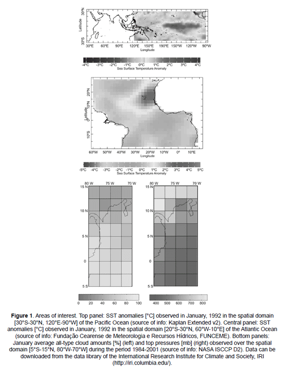
Historical time series of mean monthly SSTs observed in the El Niño 3.4 region of the equatorial Pacific [5°S-5°N, 120°W-170°W] (Barnston, Chelliah and Goldenberg, 1997) over the period from January, 1950 through August, 2005 are also processed to support the analyses. SSTs in this region exhibit an intra-annual cycle with a peak occurring during the months of April, May, and June, when surface temperatures reach values of about 27.5 °C. In January, in particular, SSTs tend to reach values of about 26.5 °C under normal conditions, below the minimum threshold of 300 K necessary to initiate deep convection (Ramanathan and Collins, 1991). During El Niño events, an increase of almost 0.6 °C is generally observed throughout the year, with a maximum change of +0.8 °C in the month of January.
Monthly SSTs observed in the spatial domain [19°S-29°N, 60°W-16°E] of the tropical Atlantic Ocean over the period spanning from January, 1964 to December, 2007 are also included. In this region, according to Zebiak (1993) and Wang (2005), "an interannual phenomenon similar to but weaker and more frequent than the Pacific El Niño" also takes place. The largest SST anomalies occur in the eastern equatorial Atlantic (see figure 1) and are mostly observed during the summer months of the Northern Hemisphere, although some events have also occurred in the boreal winter (Wang, 2005).
Finally, all-type cloud amounts and top pressures observed over the spatial domain [5°S-15°N, 80°W-70°W] during the period from July, 1983 through August, 2001 are included in the analyses (see figure 1). In January, the all-type cloud amounts observed over the selected spatial domain range from 25-40 % on the Colombian Caribbean Sea to 70-85 % along the Colombian Andes and near the equator. The all-type top pressures observed in the same month range, in turn, from 300-400 mb on the Colombian and Peruvian Amazon regions to 750-850 mb on the Colombian Caribbean Sea. Over the grid point 03°45’N-76°15’W, where the Andean high-altitude area (Los Nevados Natural Park and its surroundings) is located, the January all-type cloud amount and top pressure, averaged over the period 1984-2001, reach values slightly above 75 % and 500 mb, respectively.
3. METHODS
Empirical orthogonal function (EOF) modes and principal components (PCs) are determined for January, February, July, and August SST anomalies. The EOF analysis decomposes the spatio-temporal variations of the large SST gridded datasets into combinations of orthogonal spatial patterns with corresponding PCs in linear fashions (Lorenz, 1956; Wang and An, 2005). Finally, simple correlation analyses between the El Niño 3.4 SST anomalies/ the first two PCs of SST anomalies, and the all-type cloud amount/top pressure records are conducted. Linear trends that are statistically significant at a 0.05 significance level are removed from the time series before estimating the correlation coefficients. Only the first PCs are discussed since they explain most of the spatio-temporal variability of SST anomalies.
4. RESULTS
EOF modes and PCs. Figure 2 depicts the first two empirical orthogonal function modes of January SST anomalies observed in the 30°S-30°N and 15°S- 15°N Indo-Pacific tropical regions over the period 1942-2007, as well as in the 30°S-30°N tropical Atlantic region over the period 1964-2007. The first EOF modes of January SST anomalies observed in the selected Indo-Pacific regions represent the mature phase of ENSO. The leading EOF mode of January SST anomalies observed in the tropical Atlantic region depicts the equatorial monopole structure (Li, 2001). The second important mode observed in this latter region is the North-South inter-hemispheric gradient of SST anomalies, or so-called meridional inter-hemispheric dipole mode (Li, 2001). Table 1 shows the percentages of the spatio-temporal variability of SST anomalies explained by the first and second modes for all analyzed regions.
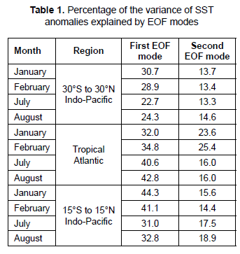
Figure 3 depicts the first two principal components of January, February, July, and August SST anomalies observed in the same spatial domains. The first principal components (PC1s) of January, February, July, and August SST anomalies observed in the 30°S-30°N and 15°S-15°N Indo-Pacific regions exhibit statistically significant trends over the period 1942-2007. The corresponding PC1s observed in the 30°S-30°N tropical Atlantic region over the period 1964-2007 also show statistically significant trends. The slope of the linear trend exhibited by the PC1 of January SST anomalies observed in the 30°S-to-30°N Indo-Pacific region reaches -0.1756/year (decreasing trend, toward El Niño); 15.3 % of the variance of this PC1 can be explained by the fitted linear trend. PC1 values exceeded the +1.0 standard deviation (SD) envelopes during the strong 1955-56, 1973-74, 1975- 76, and 1988-89 La Niña events. PC1 values during the strong 1972-73, 1982-83, and 1997-98 El Niño events exceeded, in turn, the -1.0 SD envelopes. Over the period from 1951 to 1976, nine La Niña events (three weak, three normal, and three strong) and only three El Niño events (two normal and one strong) took place. Over the period 1977-2004 only three La Niña events (two normal and one strong) and eight El Niño events (five normal and three strong) occurred. If the first PC of January SST anomalies were to be divided into two sub-series, the fitted linear trend would exhibit an increasing (positive, toward La Niña) trend with a slope of about +0.1643/year over the period 1951-1976, and a small decreasing (negative, toward El Niño) trend with a slope of about -0.0405/year over the period 1977-2007.
Correlation coefficients: Figure 4 depicts the correlation coefficients between January all-type cloud amounts observed over the spatial domain [5°S-15°N, 80°W-70°W] during the period from 1984 through 2001, and (a) the January SST anomalies observed in the El Niño 3.4 region, (b) the first principal component of January SST anomalies observed in the 30°S-30°N-belt of the Indo-Pacific region, (c) the first principal component of January SST anomalies observed in the 15°S-15°N-belt of the Indo-Pacific region, and (d) the first principal component of January SST observed in the tropical Atlantic Ocean. January SST anomalies in the El Niño 3.4 region explain between 22 % and 59 % of the year-to-year variability of January all-type cloud amounts observed over the Colombian Andean and Pacific regions. The strongest correlation coefficient of -0.770 is observed in the grid point where the Andean high-altitude area is located. The PC1 of January SST anomalies observed in the 30°S-to-30°N-belt of the Indo-Pacific region explains, in turn, between 26 % and 72 % of that year-to-year variability. Again, the highest correlation coefficient of +0.848 is observed in the same grid point. The PC1 of January SST anomalies observed in the 15°S-15°N-belt of the Indo-Pacific region explains between 26 % and 71 % of that year-to-year variability. The highest correlation coefficient also lies in the same grid point. Finally, the PC1 of January SST observed in the tropical Atlantic Ocean explains between 18 % and 32 % of the yearto- year variability of January all-type cloud amounts observed over the northeastern portion of the Colombian Andean region. This PC1 explains almost 28 % of the year-to-year variability of January all-type cloud amounts observed over the grid point where the Andean high-altitude area is located. Only a few dispersed grid points in the selected spatial domain [5°S-15°N, 80°W-70°W] exhibit statistically significant correlation coefficients in the months of February, July, and August (figures not shown).
5. CONCLUSIONS AND IMPLICATIONS
The base state change in average tropical Pacific SSTs (Yamaguchi and Noda, 2006; Meehl et al., 2007) is defined by the spatial anomaly pattern correlation coefficient between the linear trend of SSTs in the 1 %/year CO2 increase climate change experiment and the first EOF of SSTs in the control experiment over the spatial domain [10°S-10°N, 120°E-80°W]. Positive correlation coefficients indicate that the mean climate change has an El Niño-like pattern, and negative values are La Niña-like. Based on the output of 13 out of 16 coupled atmosphere-ocean general circulation models, and taking into account the skill of the present-day El Niño-Southern Oscillation phenomenon (ENSO) simulations, it can be argued that more El Niño-like conditions are expected in the trend-ENSO pattern correlation (van Oldenborgh, Philip and Collins, 2005; Yamaguchi and Noda, 2006; Meehl et al., 2007). Our analyses suggest that the PC1s of January SST anomalies observed in the 30°S-to- 30°N and 15°S-to-15°N Indo-Pacific regions exhibit statistically significant trends over the period 1951- 2007 that were accompanied by more El Niño-like conditions over the last 28 years of the observational period. The PC1s of January SST anomalies also exhibit statistically significant changes in the mean, related to changes in the slopes of the "long-term" linear trends, that occurred around 1976. This abrupt change is consistent with the observed and previously discussed mode shift that occurred in the tropical Pacific in that year (Fedorov and Philander, 2001; Gordon and Giulivi, 2008).
Outputs from general circulation model ensembles suggest that increases in cloud cover in the vicinity of the tropopause (and decreases below) are very likely to occur at all latitudes -more consistent outside the tropics- under a future warmer world (Meehl et al., 2007). In general, simulation outputs indicate an increase in the altitude of clouds overall. Much of the low latitudes are expected to experience a decrease in net cloud cover over all the layers, after allowance for the overlap of clouds. Extrapolation of our estimated trends suggest that the PC1 of January SST anomalies for the 30°S-30°N Indo-Pacific region could reach an expected value of -15.45, in the range [-7.99; -22.92], by 2050. If a strong El Niño event were to occur in that year, the expected PC1 would likely reach a value of -29.26. If a strong La Niña event were to occur, the expected PC1 would likely increase to -3.12. The January all-type cloud amount would likely decrease to 68.7 %, in the range [63.8 %; 73.6 %], under normal or non-El Niño conditions. A strong El Niño event would reduce this monthly average value to almost 60 %; a strong La Niña event would increase it to 76.8 %. The decrease of 6.8 % under normal conditions, relative to the period 1984-2001 (i.e. a rate of decrease of about 0.14 %/year), is 1.4 times greater than (but consistent with) the -2.0 % annual mean change in total cloud area cover expected for the period 2080 to 2099, relative to 1980 to 1999, under the SRES A1B scenario (Meehl et al., 2007).
Actionable and verifiable adaptation strategies to long-term climate change have a lot in common with strategies for anticipating and managing current climate variability. In other words, an effective way for assisting our society to be better prepared for the ongoing global change is by assisting it to cope better with current climate variability and climate-related events. Many of the climatic conditions that could be expected in the selected high-altitude environment in a future warmer world -increases in sunshine, diurnal temperature range, minimum, mean, and maximum temperatures, as well as decreases in relative humidity and the total number of foggy days (i.e. increases in the total number of sunny, clear-sky days)- are quasi-periodically realized in the warm events of ENSO. ENSO is the strongest signal in the inter-annual variability of the ocean-atmosphere coupled system and is the main forcing mechanism of Colombia’s hydroclimatology at that timescale. ENSO plays out every two to seven years and has numerous impacts on many sectors globally (water resources, agriculture, health, among many others), and therefore has been drawing great scientific attention and has prompted a strong observational system.
Our analyses suggest that 72 % of the variance of cloud cover conditions over the area and the surroundings of Los Nevados Natural Park during the month of sunshine maxima is explained by the first principal component of SST anomalies observed in the 30°S-to-30°N belt of the Indo-Pacific region in that month, the latter representing the mature phase of ENSO. They also indicate that more El Niño-like conditions are likely to occur in the years to come. Thus, these results combined with the observed impacts of ENSO allow us to think that the warm phase of this phenomenon can be used as a proxy for future climate scenarios in the high-altitude ecosystems within the selected region, and how harsh conditions might affect these highly strategic environments. We have to say that although we have obtained high levels of statistical significance, our analyses have several caveats, most of them derived from the use of remote sensing data, causing reason to be taken with caution. In particular, the spatial resolution of the satellite-derived records is a main obstacle to thoroughly predicting the potential impacts of changes in regional cloud cover on paramos and other highaltitude environments. The spatial extent of each pixel is so large that it covers not only paramos, but a large array of tropical systems ranging from tropical dry forests in the inter-Andean valleys of the Cauca and Magdalena rivers, to even tropical wet forests on the Pacific lowlands.
Previous analyses suggest that changes or trends in time series of temperatures and pressures of all type cloud tops have not occurred in the area over recent years (Ruiz et al., 2008), but reductions in the amount of all type clouds took place over the observing period. It was also reported that in higher altitudes (ca. 4,150 m) the total number of foggy days per month has slightly decreased over the past two decades, and hence, the total number of sunny days per month has increased. Based on our analysis, we can argue that there is likely to be a decrease in the net cloud cover over this area of the Colombian Central mountain range over the next 50 years. These expected changes could affect several physical processes, including the water cycle and the net radiative balance. Decreases in cloud and fog cover directly imply higher incoming solar radiation amounts, higher near-surface ambient temperatures and increased evaporation, which combined could contribute to a further retreat of local mountain glaciers and snowfields, and an accelerated disappearance of high-altitude water bodies and aquatic microhabitats.
Expected changes could also have numerous ecologically-related effects such as increases in the rate of desertification of mountain habitats and shifts in species ranges (species will be forced to adapt to new climatic conditions, move towards new climatic niches or become extinct). They could also induce shifts in major vegetation zones or biomes: e.g. higher incoming solar radiation would probably enhance the temperature of paramo topsoil and hence would induce upward displacements of the upper forest line (Körner and Paulsen, 2004). Finally, changes in incoming solar irradiance could produce drier and warmer vegetation layers and soil conditions, which in turn could set the conditions for a rapid spread of high-altitude fires and could directly and indirectly (e.g. faster decomposition rates of organic matter) lead to a decrease in organic carbon storage in both below-ground soils and peat accumulations, causing a net release of carbon to the atmosphere (Buytaert, Cuesta-Camacho and Tobón, 2011).
We think that the analyses and results presented here can help us better understand and predict the consequences of expected changes in cloud and fog cover in the Andes, and could give us some insights into the choice of local climate-informed conservation practices, adaptation strategies, and general decision-making processes. We claim again that ambitious sustainable management strategies are now urgently required to protect these unique, rich, fragile, and highly endangered high-altitude environments.
ACKNOWLEDGEMENTS
I wish to thank Dr. A. Barnston (International Research Institute for Climate and Society, Columbia University in the City of New York, US) for providing his valuable input to the paper. I also acknowledge the helpful suggestions made by three anonymous peer-reviewers who read and commented this manuscript.
REFERENCES
Barnston, A. G.; Chelliah M. and Goldenberg S. B. (1997). Documentation of a highly ENSO-related SST region in the equatorial Pacific. Atmosphere-Ocean, vol. No. 35: pp. 367-383. [ Links ]
Bradley, R. S.; Vuille M.; Diaz H. F. and Vergara W. (2006). "Threats to water supplies in the tropical Andes". Science, vol. 312, No. 5781 (June), pp. 1755-1756. [ Links ]
Buytaert, W.; Cuesta-Camacho F. and Tobón C. (2010). "Research review: Potential impacts of climate change on the environmental services of humid tropical alpine regions". Global Ecology and Biogeography, vol. 20, No. 1 (January), pp. 19-33 (in press). [ Links ]
Cane, M. and Zebiak S. E. (1985). "A theory for El Niño and the Southern Oscillation". Science, vol. 228, No. 4703 (May), pp. 1085-1087. [ Links ]
Díaz-Granados, M. A.; Navarrete J. D. and Suárez T. (2005). "Páramos: hidrosistemas sensibles". Revista de Ingeniería Universidad de los Andes, No. 22 (Noviembre), pp. 64-75. [ Links ]
Fedorov, A. V. and Philander G. S. (2001). "A stability analysis of tropical ocean-atmosphere interactions: bridging measurements and theory for El Niño". Journal of_ Climate, vol. 14, No. 14 (July), pp. 3086-3101. [ Links ]
Gordon, A. L. and Giulivi C. F. (2008). "Sea surface salinity trends over fifty years within the subtropical North Atlantic". Oceanography, vol. 21, No. 1 (March), pp. 22-31. [ Links ]
Gutiérrez, M. E.; Zapata P. A. and Ruiz D. (2006). El entendimiento de las señales de cambio climático o variabilidad climática en la oferta hídrica superficial de cuencas hidrográficas en zonas de alta montaña. Estudio de caso: río Claro, Parque Nacional Natural Los Nevados. Trabajo de grado (Ingeniería Ambiental). Escuela de Ingeniería de Antioquia. (Colombia). 160 p. [ Links ]
Instituto de Hidrología, Meteorología y Estudios Ambientales, IDEAM (2001). Colombia: primera comunicación nacional ante la Convención Marco de las Naciones Unidas sobre el Cambio Climático, Bogotá, Colombia. In: http://www.ideam.gov.co/publica/cambioclimatico/PrimeraComunicacionColombia.pdf [ Links ]
Instituto de Hidrología, Meteorología y Estudios Ambientales, IDEAM. Páramos y ecosistemas alto andinos de Colombia en condición hotspot y global climatic tensor. Castaño, C. (ed.), Bogotá: 2002. 387 p. Available in: http://www.ideam.gov.co/publica/index4.htm [ Links ]
Kaplan, A.; Cane M.; Kushnir Y.; Clement A.; Blumenthal M. and Rajagopalan B. (1998). "Analyses of global sea surface temperature 1856-1991". Journal of Geophysical Research, vol. 103, No. 18, pp. 567-589. [ Links ]
Körner, C. and Paulsen J. (2004). "A world-wide study of high altitude treeline temperatures". Journal of Biogeography, vol. 31, No. 5 (May), pp. 713-732. [ Links ]
Li, Z. X. (2001). "Thermodynamic air-sea interactions and Tropical Atlantic SST dipole pattern". Physcs and Chemistry of the Earth (B), vol. 26, No. 2, pp. 155-157. [ Links ]
Lorenz, E. N. Empirical orthogonal functions and statistical weather prediction. Science Report 1, Cambridge, MA: Masachusetts Institute of Technology, 1956. 49 p. [ Links ]
Meehl, G. A.; Stocker T. F.; Collins W. D.; Friedlingstein P.; Gaye A. T.; Gregory J. M.; Kitoh A.; Knutti, R.; Murphy J. M.; Noda A.; Raper S. C. B.; Watterson I. G.; Weaver A. J. and Zhao Z.-C. (2007). Global Climate Projections. In: Climate change 2007: the physical science basis. Contribution of Working Group I to the Fourth Assessment Report of the Intergovernmental Panel on Climate Change Solomon, S.; D. Qin; M. Manning; Z. Chen; M. Marquis; K. B. Averyt; M. Tignor and H. L. Miller (eds.). Cambridge University Press, Cambridge, United Kingdom and New York, NY, USA. [ Links ]
Poveda, G.; Mesa O. J. y Vélez J. I. "Balances hidrológicos de Colombia". Universidad Nacional de Colombia Sede Medellín: Publicaciones Postgrado en Aprovechamiento de Recursos Hidráulicos, 2001. 150 p. [ Links ]
Ramanathan, V. and Collins W. (1991). "Thermodynamic regulation of ocean warming by cirrus clouds deduced from observations of the 1987 El Niño". Nature, vol. 351, No. 2 (May), pp. 27- 32. [ Links ]
Reynolds, R. W. and Smith T. M. (1994). "Improved global sea-surface temperature analyses using optimum interpolations". Journal of Climate, vol. 7, No. 6, pp. 929-948. [ Links ]
Ruiz D.; Moreno H. A.; Gutiérrez M. E. and Zapata P. A. (2008). "Changing climate and endangered high mountain ecosystems in Colombia". Science of the Total Environment, vol. 398, No. 1-3. pp. 122-132. [ Links ]
Ruiz, D.; Arroyave M. P.; Molina A. M.; Barros J. F.; Gutiérrez M. E. and Zapata P. A. (2009). Signals of climate variability/change in surface water supply of high-mountain watersheds. Case study: Claro River high mountain basin, Los Nevados Natural Park, Andean Central Mountain Range, Colombia. World Bank Group Project 7147577. School of Engineering, Medellin, Colombia, 207 pages. [ Links ]
The World Bank Group -WBG-. Colombia-Integrated National Adaptation Program Project. Documents & Reports. Washington, D. C., 2006. [ Links ]
The World Bank Group -WBG- Assessing the potential consequences of climate destabilization in Latin America. Latin America and Caribbean Region Sustainable Development. Working Paper 32. W. Vergara (ed.). Washington, D. C., 2008. 115 pp. [ Links ]
Unidad Administrativa Especial del Sistema de Parques Nacionales Naturales, UAESPNN. Información general del Parque Nacional Natural Los Nevados. Programa de Conservación y Manejo del Parque Nacional Natural Los Nevados. Manizales, Colombia, 2000. [ Links ]
Van Oldenborgh, G. J.; Philip S. Y. and Collins M. (2005). "El Niño in a changing climate: a multi-model study". Ocean Science, vol. 1, No. 2 (October), pp. 81-95. [ Links ]
Wang, C. ENSO, Atlantic climate variability and the Walker and Hadley circulations. In: The Hadley circulation: present, past and future. Diaz, H. F. and Bradley, R. S. (eds.). Dordrecht, The Netherlands: Kluwer Academic Publishers, 2005. pp. 173-202. [ Links ]
Wang, B. and An, S-I. (2005). "A method for detecting season-dependent modes of climate variability: S-EOF analysis". Geophysical Research Letters, vol. 32, L15710. [ Links ]
Yamaguchi, K. and Noda, A. (2006). "Global warming patterns over the North Pacific: ENSO versus AO". Journal of the Meteorological Society of Japan, vol. 84, No. 1 (February), pp. 221-241. [ Links ]
Zebiak, S. E. (1993). "Air-sea interaction in the equatorial Atlantic region". Journal of Climate, vol. 6, No. 8, pp. 1567-1586. [ Links ]

