


Services on Demand
Journal
Article
 English (pdf)
 Article in xml format
 Article references
 Send this article by e-mail
Indicators
-
 Cited by SciELO
 -
 Access statistics
Related links
-
 Cited by Google
 -
 Similars in
SciELO
Similars in
SciELO -
 Similars in Google
Share

 Permalink
Revista EIA
Print version ISSN 1794-1237
Rev.EIA.Esc.Ing.Antioq no.spe2 Envigado June 2015
EVALUATION OF SOIL MOISTURE USING TOPOGRAPHIC (DEM), CLIMATE AND SOIL PARAMETERS IN A PIEDMONT AREA OF VILLAVICENCIO
EVALUACIÓN DE LA HUMEDAD DEL SUELO USANDO PARÁMETROS TOPOGRÁFICOS (DEM), CLIMÁTICOS Y EDÁFICOS EN UN SECTOR DEL PIEDEMONTE DE VILLAVICENCIO
AVALIAÇÃO DA UMIDADE DO SOLO USANDO PARÂMETROS TOPOGRÁFICOS (DEM), DO CLIMA E DO SOLO EM UMA ÁREA DE COLINAS EM VILLAVICENCIO
Nancy Leiva Gutiérrez1, Yolanda Rubiano Sanabria2, Andrés Javier Peña Quiñones3
1 Ingeniera agrícola, Universidad Nacional de Colombia sede Bogotá. Especialista en Sistemas de Información Geográfica, Universidad Distrital Francisco José de Caldas. Profesional especializada, investigadora grupo Geomática, Instituto Geográfico Agustín Codazzi.
Autor de correspondencia: Leiva-Gutiérrez, N. (Nancy). Carrera 30 N. 48-51, Instituto Geográfico Agustín Codazzi. Bogotá. Teléfono: (571) Ext. 91416. Correo electrónico: nleyvag@igac.gov.co.
2 Agróloga, Universidad Jorge Tadeo Lozano. Especialista en Interpretación de Imágenes de Sentores Remotos API, Instituto Nacional de Pesquisas Espaciais. PhD. en Ciencias Agrarias, Área Suelos y Agua, Universidad Nacional de Colombia sede Palmira. Profesora Asociada Facultad de Agronomía, investigadora grupo Desarrollo Sostenible y Gestión Ambiental, Universidad Nacional de Colombia sede Bogotá.
3 Ingeniero agronómico, Universidad Nacional de Colombia sede Palmira. MSc. en Metereología, Universidad Nacional de Colombia sede Bogotá. Coordinador de la línea de investigación Medición de amenazas y vulnerabilidades e identificación de oportunidades para adaptar la caficultura colombana a la variabilidad climática, Centro Nacional de Investigaciones del Café (Cenicafe).
Artículo recibido: 14-XII-2013 / Aprobado: 29-IX-2014
Disponible online: 30 de octubre de 2014
Discusión abierta hasta diciembre de 2016
ABSTRACT
A methodology, based on the use of digital elevation model, DEM, Was used to assess soil moisture in a depositional piedmont area of the municipality of Villavicencio in two periods, one wet and one dry. Additionally, the spatiotemporal variation of both climatic and spatial soil moisture and their availability through water balance were considered. This work examines three digital elevation models: SRTM, ASTER, 30m and another generated by photogrammetric restitution (resolution 10m). DEM with the highest quality was SRTM, and this was the source to get topographic and hydrological parameters; Tasseled Cap transformation generated from Landsat 7ETM+ satellite images and physical variables allowed explaining the soil moisture. By interpolation, using IDW and Kriging methods, maps of climatic variables were obtained in order to compare the results with the available moisture through monthly water balance. Multivariate regression indicated that during the rainy season the topographic characterization variables such as classification of curvature, slope and topographic position index are relevant in combination with the bulk density and sand percentage. Inversely; for dry season, the contribution of landforms and topographic relative moisture index with sand percentage inversely explain the soil moisture.
KEY WORDS: Digital Elevation Models; Geomorphometric Variables.
RESUMEN
Se estableció una metodología para evaluar la humedad del suelo a partir de atributos derivados de un modelo digital de elevación, MDE, en un sector del piedemonte depositacional del municipio de Villavicencio, en dos periodos, uno húmedo y uno seco. Adicionalmente se consideró la variación espacio-temporal de aspectos climáticos y edáficos y disponibilidad de la humedad a través del balance hídrico. Se evaluaron tres MDE: SRTM, ASTER, de 30 m y otro, producto de restitución fotogramétrica (resolución 10 m). SRTM resultó ser el de mejor calidad, del cual se derivaron parámetros topográficos e hidrológicos, La transformada Tasseled Cap, generada de imágenes Landsat 7ETM+ y variables físicas contribuyeron a explicar la humedad del suelo. Mediante interpolación, utilizando métodos IDW y Kriging se obtuvieron mapas de variables climáticas, para contrastar resultados con la humedad mensual disponible a través del balance hídrico. La regresión multivariada precisó que en época lluviosa el aporte de variables como clasificación de curvatura, pendiente e índice de posición topográfica son relevantes, en combinación con la densidad aparente y el porcentaje de arena, en forma inversa; en época seca, las formas de terreno e índice topográfico de humedad relativa explican la humedad del suelo, e inversamente, el porcentaje de arena.
PALABRAS CLAVE: Modelo de elevación digital; variables geomorfométricas.
RESUMO
É estabelecida uma metodologia para avaliar a umidade do solo a partir de atributos derivados de um modelo digital de elevação, MDE, em uma seção da colina de deposição do município de Villavicencio, em dois períodos, um molhado e um seco. Além disso, foi considerada a variação espaço-temporal de aspectos climáticos e do solo e a disponibilidade da umidade através de balanço hídrico. Eles foram avaliados três MDE: SRTM, ASTER, 30 m e outro produto de restituição fotogramétrico (resolução de 10 m). SRTM provou ser de melhor qualidade, do qual derivaram se parâmetros topográficos e hidrológicos, A transformação Tasseled Cap, gerada a partir de imagens Landsat e 7ETM+ e variáveis físicas ajudam a explicar a umidade do solo. Por interpolação utilizando métodos IDW e Kriging foram obtidos mapas de variáveis climáticas, para testar os resultados com umidade mensal disponível através do balanço hídrico. A regressão multivariada precisa que durante a estação chuvosa o aporte de variáveis como classificação de curvatura, inclinação e índice de posição topográfica é relevante, em combinação com a densidade aparente e o per cento de areia, inversamente; na estação seca, a forma da terra e índice topográfico de umidade relativa umidade explicam a umidade do solo, e, inversamente, a percentagem de areia.
PALAVRAS-CHAVE: Modelos digitais de elevação; variáveis geomorfométricas.
1. INTRODUCTION
The demand for information on soil water content has increased. Soil moisture, stored near the surface affects a variety of Earth system interactions in a wide range of spatial and temporal scales. With today's availability of digital elevation data and computational techniques for the analysis of soil, topographic attributes have been gaining importance in the different environmental investigations. The spatiotemporal variability of soil moisture provides information necessary to assess the hydrological behavior, both locally and regionally, but its distribution requires analysis of many variables and their interrelationships. There are many applications in which it is necessary to specify the wetness condition of the soil, especially in meteorology, hydrology and agriculture: soil survey, land evaluation, erosion and landslides, climate modeling and prediction, and planning of sustainable lands use, among others (Teuling, et al., 2006; Qui, et al., 2009).
Moreover, digital elevation model (DEM) data are a source of high potential to characterize the relief as quantitative (visual and mathematical), being a major input for various models that look for estimating the soil condition. Topography, one of the factors that control soil moisture, is perhaps the element that has been most extensively studied (Famiglietti, et al., 1998; Moore, et al., 1988; Western, et al., 1999; Qui, et al., 2001), leading to the generation of topographic and hydrological indices to predict moisture in function of relief (Beven & Kirkby, 1979; Barling, et al., 1994). However, the influence of factors such as soil properties, vegetation, precipitation and evaporation cannot be ignored; it is very useful and complex to establish the importance of each factor and their mutual and multiple influences (Cantón, et al., 2004; Wester, 2004; Dyer, 2009).
Likewise, satellite image processing provides additional information of vegetation and soil using special techniques to produce indices that detect a specific aspect of the Earth's surface. Particularly in Tasseled Cap transformation (Crist, et al., 1986), moisture is obtained from the contrast between the reflectances in the short wave infrared (SWIR) and the visible/near infrared (VNIR). Therefore, these tools contribute for determining soil moisture integrating soil conditions and climate variables in a depositional area around Villavicencio municipality piedmont sector of the municipality of Villavicencio.
2. MATERIALS AND METHODS
2.1. Study area
The study area is on the eastern slopes of the Andes mountain, in Villavicencio municipality (4°06'19.70"N and 73°29'33.45"W), has 674.12 km2 and its importance lie in the potential for agriculture and livestock (Figure 1).
Depositional piedmont (72.2% of study area) is located at altitudes between 220 and 500 masl with relief relatively flat to slightly undulating (1-9%), and interspersed with major landforms such as floodplains and alluvial terraces (15.3%), along major rivers that cross it from west to east. To the east, the mountain landscape covers 12.5% of the extension (500 and 1333 masl, slopes 7-50%, medium long slopes and sharp and convex ridges).
The piedmont materials (clays and conglomerates), are the result of the denudative effect of the Cordillera Oriental, mostly recent heterometric alluvial and alluvial sediments from fine to coarse in the different positions of the alluvial, floodplains and overflow terraces. In the mountain area, the materials consist of chloritic schists, shales, conglomerates, clays and sandstones, which have given rise to coarse-textured soils, with a mixture of stone, gravel and pebbles in a clayey matrix.
The mountain area has a very moist average climate, with rainfall exceeding 4000 mm per year and temperatures between 14 and 18°C. The piedmont is hot and moist; rainfall and temperatures rise gradually, in contrast with the terraces and alluvial overf low floodplains, where rainfall decreases and temperatures increase. Rainfall range varies from 2000-4000 mm.year-1 and temperatures between 24-27°C (relative moisture ranges between 65-80%; evapotranspiration between 140-170 mm.month-1). The rainfall in the region is largely determined by the intertropical convergence zone (ITCZ) and the influence of the mountainous terrain in the area is represented by the eastern slopes of the Cordillera Oriental and the Serrania de la Macarena. The ITCZ caused by the convergence of the trade winds from the northeast and southeast, in a monomodal regime.
2.2. Methodology
Figure 2 summarizes the stages followed to achieve the specific objectives of this research:
1. SELECTION OF DEM AND CALCULATION OF GEOMORPHOMETRIC PARAMETERS. The quality measure of a DEM is based on two essential qualities, horizontal resolution or level of detail and accuracy, which vary depending on the method used to generate them. The resolution or cell size is one of the most important criteria related to the DEM quality: as the size of the cell or pixel (lower resolution) increases, the generalization of the real surface increases through the model. DEM accuracy is related to the elevation values of each cell and to the cell size, and it depends on the gradient of the slope of the actual surface and the size of the unit area. As gradient increases (higher slope) and the terrain size units decrease DEM accuracy diminishes.
Quality of the variables generated depends on DEM quality. Hence, two types of statistical measurement in selected DEM were done (SRTM and ASTER of 30 m and a resolution model of 10 m originated from photogrammetric restitution and basic cartography 1:10.000). The comparison of digital elevation models result in the former (Kervyn, et al., 2006), and the latter through the DEM altitude data checking and field measurements (geodetic control points, GCP). As well, two graphic assessments of the models were made, in which contour lines are generated for the three models in order to compare morphological details information (Jacobsen & Passini, 2009).
From the model chosen by its best quality different algorithms that offer software such as SAGA® related to soil moisture were applied and topographic and hydrological parameters generated. The results were continuous raster layers to the DEM resolution selected, which were taken from the values of the variables for each of the 200 sampling points. Additionally, Tasseled Cap transformation was calculated from Landsat ETM+(September 2003) in the same points using the empirical coefficients for each band. Also was obtained the relative moisture topographic index by weighting variables such as aspect, position, degree and shape of the slope.
2. EVALUATION OF SOIL MOISTURE CONTENT AND WATER BALANCE IN TWO CLIMATIC PERIODS AND SPATIAL DISTRIBUTION ANALYSIS. Two evaluations were performed in field soil moisture using a TDR-type moisture-meter to a depth to 30 cm as well as sampling for laboratory analysis (texture, bulk and particle density, hydraulic conductivity, retention curves), basic data for the water balance in the rainy period (September) and dry period (December). These points were established in a stratified random sampling according to the distribution and extent of soil mapping units, (Martinez & Zinck, 2004), seeking to ensure the reliability of results when studying the spatial variability by controlling the distance and intensity of sampling as far as possible by access. The point's network had a total of 200 sites (Figure 3).
The analysis of the spatial distribution was considered for the period 1971-2000. Climate records mainly rainfall, temperature and evaporation, come from the 89 stations. In some cases, it was necessary to use other data (sunshine, relative, moisture and wind speed) to obtain reference evapotranspiration, ETo estimated with the modified Penman Monteith method (FAO, 2006).
Variability and spatial prediction was estimated using the multi-year average monthly precipitation, and ETo allowed generating continuous data surfaces with the same resolution of selected DEM by interpolation Inverse Distance Weighting (IDW), considered the most appropriate method, because of the few stations contained in the study area. In the case of saturation, FC, PWP, storaged water and moisture, spatial prediction models were generated through the Universal Kriging interpolation method in R, with their corresponding evaluation methods: exploratory analysis and cross-validation. All variables were represented in mm, taking into account the effective depth of the soils (IGAC, 1980).
Water balance was simplified for monthly periods after obtaining the data surface. The aims of the balance are to quantify the moisture and to determine the excess (those values that exceed saturation considering the maximum threshold that the soil moisture reaches) and which lead to runoff and deficits (at levels close to the point of permanent wilting or lower moisture limit), the state in which soil moisture is in critical condition. The balance begins in an ideal condition of total water retention, i.e. when the ground is presumed to show the largest storage: the late rainy season and early dry period. The rains begin to decrease since December, so the dry season was estimated from this month.
3. CORREL ATION OF THE RESULTS WITH CLIMATIC AND SOIL VARIABLES. By using the topographical variables generated from the best DEM and after estimating the variability and spatial prediction of the variables associated with soil water conditions, multiple regression analysis was applied in order to discover which variables (independent or explanatory variables) affect the dependent or response variable (soil moisture). Based on results, a stepwise regression was performed to obtain the simplest model (fewer parameters) that offers a better fit between the variables considered.
3. RESULTS AND DISCUSSION
The evaluation of DEMs showed that the largest differences (-37.06-46.35 m), occurred at the highest terrain points in the mountains and, therefore, the greatest RMSE values for the three DEM combinations. In general, the lowest RMSE results and the best correlation coefficient were obtained for SRTM and the resolution 10m model in different transects, in both areas, flat and hilly. This was confirmed with the asymmetry coefficients for these models. Table 1.
Comparing the altitude values of the DEM versus measurements of field control points, GCP, showed effects of underestimation or overestimation regarding GCP, in all models being positive (overestimation) in plain areas and negative (underestimation) in higher zones. The best values of RMSE and correlation coefficient R2 (0.9968), were for the SRTM model.
In the visual assessment, a smoothing in the forms of the ASTER model profiles was seen, mainly in the mountain area, due to the influence of vegetation, as cited by Jacobsen & Passini (2009) who evaluated this model in similar areas of the world. Additionally, their morphological details are less clear in the mountain areas, which occur in various sectors of the country, where the sensor uses a small number of stereo models (stacks), in order to generate the elevation model.
The final quality test is made for the model of 10 m spatial resolution, from which better quality was expected due to its pixel size. However, when some details are evaluated in the model, a "terrace" effect or staggering is produced because no clear altitudinal differences are generated, i.e. the altitude remains constant over large areas, and when it changes, it has abrupt height changes that end up affecting the quality of the parameters expected from the selected DEM. This was an additional reason for the DEM not be reliable as a source of morphometric and hydrological data of interest in the study. These inaccuracies may be due to low quality control specifications when evaluating a very low number of pixels in the process of generating the digital elevation model.
The above reasons revealed better adjustment results of SRTM with the terrain data than the other two models mainly in slightly sloping flat surfaces or piedmont area. Software like R and SAGA were used to generate the different topographic, climate and water parameters, namely, slope, aspect, horizontal and vertical curvatures and indexes as convergence, topographic wetness (TWI), topographic position (TPI), roughness, relative moisture.
The results of these parameters were evaluated for the different sampling sites along with the different edaphic variables. In general terms, the dominant slope is between 0-7%(78.2%), in the piedmont, but highlights some areas with slopes 7-12%(7.98%), at the foot of slope, the remaining percentage is in the mountain area, indicating that its influence on the surface and subsurface flow rate and runoff rate may be low in most of the study area. According to the distribution of horizontal curvature values in the histogram, the variable occurs between -0.44 and 0.371, predominantly near zero, which identify the depositional piedmont flat area. However, there are sectors intermixed and widely distributed throughout the area of interest, with curvature values between 0.067 and 0.168, indicating landforms with some convexity, thus favoring the movement of water in the soil, there are also sectors with negative curvature values or concave zones conducive to moisture accumulation. The vertical curvature showed a similar behavior. The best effect of curvature is its combination, particularly in convex/concave and plane/ concave areas, facilitating the movement and storage of soil moisture.
The mountain areas have combined curvatures, convex type, mainly in areas located at the tops, and in intramountain sectors, valleys and low parts of the slopes, lower slope, horizontal curvature values range between -0.440 and -0.21, indicating concave curvatures where the water flow converges and favors moisture retention. Figure 4 shows a detail of this curvature in two terrain profiles of mountain areas and piedmonts, displaying greater variability of concave and convex shapes along the piedmont in short distances but with smaller altitude changes.
Indexes derived from DEM were calculated, evaluating each sector separately; the coefficients of variation for each parameter are lower in piedmont sector, which is associated with relief uniformity regarding altitudes and slight changes in the slope, as evidenced also in curvature analysis. In the mountainous area there is greater variation in the values of these parameters, which allowed identifying areas where moisture behavior tends to converge and therefore easier to stay on the terrain and areas where topography or landforms facilitate water flow and its accumulation in soil is low.
The best effect of the terrain on moisture is reflected in TWI, which showed high values associated with landforms as riverbank and water meadows of the floodplains and consequently soils that could be considered more favorable to store moisture. However, most of these soils come from alluvial materials and have thick textures in sand or clay matrix that not easily retain moisture inside, with the aggravating circumstance that some of these areas are found in flood areas. The predominant texture of the mountain area is soil is loamy/sandy and it is associated more to a low index, plus the fact that the slope by gravity action makes the water stay in soil. Some quantitative results, for some sampling points, appears in Table 2.
The behavior of the average monthly precipitation in the study area for the period 1971-2000, confirmed that they are lower from December to March and greater from April to November. Along the piedmont there are also significant variations in the average monthly rainfall amount: intensity increases gradually since April from west to east, from the mountain area, with its highest values in May and June, going down in the same direction until September, the average monthly rainfall increasing in October and November, to start the dry season during December.
The water balance results are summarized in Table 3. It shows the monthly average ranges for rainfall and reference evapotranspiration ETo in mm, which are the data of soil moisture input and loss, the deltaH value or soil moisture gradient, makes the difference between the two previous variables used to calculate the available moisture in soil and its monthly averages deficit and excess water. The deficits coincide with the dry months and the excesses, as expected, occur in the months when rainfalls are higher. The available water stored in the soil ranges in a lower threshold, which is the PWP and can reach its maximum value, in saturation.
Several simplifications were assumed to make the water balance: water supply comes from rainfall only. Outputs, reference evapotranspiration is only considered. Lateral or vertical movement of water, percolation surface, groundwater or capillary and runoff were not taken into account; and soil moisture for a specific month is fully available for the next period, regardless of its amount.
Spatial variations of excess soil moisture are bet ter appreciated from April, spreading from the southwestern to the north sector of the study area. The maximum cumulative excess area occurs in June in the East of the Eastern Cordillera; thereafter, they decrease until November to the southeastern sector (Figure 5). This trend is similar to presented in the monthly average rainfall, and is corroborated by the correlation of soil and topographic variables.
Variability water deficit starts in the southeastern area of study in December and is spreading in the three months to the northeast; in the southeastern sector only until June wetter conditions can be observed that are causing excess until November, as shown in Figure 5 and Figure 6 respectively. In general, the ranges of moisture deficits are low during the year and in localized areas, mainly into central and southeastern piedmont, with average monthly not exceeding 160 mm that can be supplied by irrigation.
Despite the significance of the analysis with the weather data series for the period 1971-2000, it should be noted that the monthly values may mask the actual behavior of the conditions illustrated in the soil moisture through the water balance. This region has a high and irregular monthly rainfall in its intensity and frequency distribution (e.g, the number of rainy days per month has a wide variation, which can be between 3 and 27 days, according to data). Statistical measures are recorded in Table 4, which shows that the values of the central tendency measures (mean and median) are similar in all cases, so that the average can be seen as a good indicator of the variables analyzed. On the other hand, scattering of PWP, available water and moisture in the dry season (Moisture2), is high, indicating significant changes in the spatial distribution.
Table 5 shows the results of spatial prediction models: four variables exhibit data spatial trend that were collected with a quadratic model on the spatial location of sample sites; this behavior was incorporated in the equations systems of the Universal Kriging. There was no spatial trend in the case of saturation and moisture variables in the rainy season (Moisture1), which suggests that these properties have only small fluctuations around their average values. The spatial correlation models with the best predictions were Gaussian for variables with a trend and Matern for variables without a trend. These patterns are typical of phenomena with little variability and they tend to show smooth behavior within the significant spatial correlation limits, i.e., for distances that do not exceed the range ( ).
).
The spatial correlation magnitude of the processes is analyzed with the range extension. In this case, there is high correlation for moisture in the rainy season showing a process of global behavior, with some relationship in moisture values at points separated up to 27 km away approximately. In all other cases, the correlation is low, not exceeding 1.5 km, which is typical of local behavior processes, where only quite close points are associated. The nugget effect (σ^2) is quite high in comparison to the partial sill (τ^2) may be due to measurement errors associated with the spacing between sampling sites, which was large compared to the spatial variability of the studied spatial processes; hence, the structure could not be observed at short distances. This aspect was proved in the detail of the DEM transects and profiles, in which for short distances (100 to 200 m) there are rapid changes in terrain altitudinal variation. This shows that the separation between the measurements should have been of this type by the landforms variability and not for distances of 500 m or greater as it was. Finally, the errors obtained from the cross-validation are low. Thus, semivariance models and estimated parameters chosen provide good predictions in unsampled sites.
Regression process coincided with the results of measuring the soil moisture in the defined periods, physical and topographical characterization and spatial location of the samples. The initial correlation coefficients are shown in Table 6.
The results showed that the highest correlation explanatory variables are the physical properties of soil, location and the Tasseled Cap transformation, since data scattering is wide for most variables, this mean that the linear relationship between them is very low. It is important to note that despite expected, the topographic variables did not show great significance to explain moisture none of the two periods.
Due to the low correlation primarily for topographic variables, it was decided to analyze the effect of some of them, qualitative variables, but considered explanatory about the response variable behavior; that's why they were included in the model, building new variables called "dummy" or "indicator". Such is the case of curvature classification type, soil map units and landforms. At the same time the "artifice" was used to examine the influence of these variables on timely soil moisture and to try to improve the final regression, which increased the value of R2 in 3% and 8% for the wet and dry seasons respectively. Multiple linear regression models were re-estimated by least squares method, for each period including new qualitative variables and then with the selection method of variables step by step, we extracted only those variables considered of greater significance on soil moisture. Table 7 summarizes these results for rainy season.
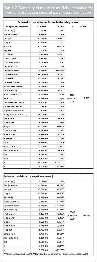
By reducing the independent variables and improving the goodness of fit, in the rainy period, highlights the topographical characterization variables contributions: combination convex/concave curvature, slope, TPI and Tasseled Cap transformation, in explaining the moisture soil. The former can be explained according to Olaya (2004), who argues that the combination of both curvatures gives a more effective geomorphological reality of each cell and allows discerning on the direct relation of moisture, the water flowing in the direction of the maximum slope line. Hence, the combined effect are initially accelerated, as a result, there is an accumulation of soil moisture, which favors this condition for dry days or periods. In the case of topographic position index, TPI, basically those areas associated to mountain and piedmont depression sectors offer better correlation with soil moisture in rainy period. Correlation for Tasseled Cap, showed a good relationship between the high values of the variable with the water content and the vigor vegetation, as expressed by Crist, et al. (1986), but it is not known how much of the variable corresponds purely to soil contribution. Areas that show higher moisture coincide with areas identified with high TWI values, even if this index showed none significance, and other as the normalized difference vegetation index keeps a direct relation with soil moisture.
Saturation and the soil field capacity likewise provide a positive contribution to the explanation of moisture in this period. Bulk density and sand content are inversely correlated. Moreover, moisture keeps a good relationship with the spatial location, directly to the north, which may be favored by the orientation of the slope (or aspect), but towards the East this relationship is reversed; it means that, when it moves in that direction, moisture decreases during the rainy season, as has also been corroborated by the water balance. Research such as those conducted by Cantón, et al. (2004) and Western, et al. (1999) in semiarid and arid regions of southeastern Spain and Australia support the influence of these topographic variables on the retention of soil moisture and other soil properties, even under conditions of topography, climate patterns and opposite soil characteristics mainly dominated by sandy soils, but comparable by similar ground conditions.
In the dry period, the piedmont landform and the topographic relative moisture indexes are important. The combination of plane/concave curvatures has a greater effect on this period and it represents areas that are not defined with sufficient identity of any of the accumulation processes and scattering of moisture, called transit zones (Olaya, 2004). In this period, the Tasseled Cap contribution was not significant. Regarding physical variables, the sand content keeps an inverse relation with moisture retention because of macroporosity and low cohesion among soil particles to facilitate the water flow and prevent its preservation in the soil profile, especially near to the surface, but bulk density was not significant. Field capacity provides an explanation of moisture since its variation is similar to available soil water. These results are consistent with those of Qiu et. al (2001), who conducted research in regions of varied topography in northern China, and found that in some soils sand content is strongly linked with moisture. The geographical position northbound helped to explain the moisture directly, as it did in the rainy period.
4. CONCLUSIONS
In the study area the influence of topography on soil moisture was few evident: gravity plays an important role on moisture soil mainly in the mountainous areas, but in piedmont area, terrain features such as landforms, in dry period or slope, TPI and any curvature combination can explain the temporal and spatial moisture variation. Other parameters derived from DEM such as convergence, topographic roughness index and TWI did not provide further explanation about soil moisture. This could be explained because the analysis is focused on the piedmont area; therefore, the generated indexes showed no significant changes throughout the sector since because they are similar in nature or the effect could not be mathematically evidenced by low altitudinal variation conditions in the sample. Thus, high correlation coefficients cannot be expected, but this does not ensure that there is no physical meaning of the variables on the moisture, maybe if a digital elevation model of better resolution and accuracy had been used.
Of the three models tested, SRTM 30 m showed a better representation of the relief features, higher quality for analysis and generation of topographic and hydrological attributes; thus, it was considered the most appropriate for the assessment of soil moisture.
Edaphic variables and their relat ion to the geomorphometric characteristics assessed played an important role for the evaluation of soil moisture, especially bulk density and sand percentage, both inversely, with saturation and field capacity since they improved model estimation and provided information to identify drier and wetter areas.
Water balance was crucial to quantify the soil moisture, however, for a good analysis of climatic variables, such as those of the study area, if you have weather data for a significant number of stations either decadal or daily, it is convenient to apply the balance in these periods for the calculation of the layers of excess or deficit to be more accurate, which is a favorable aspect to handle extreme conditions of moisture and to determine the zoning of areas subjected to flooding or drought periods.
REFERENCES
Barling, R.D.; Moore, I.D.; Grayson, R.B. (1994). A Quasi-Dynamic Wetness Index for Characterizing the Spatial Distribution of Zones of Surface Saturation and Soil Water Content. Water Resources Research, 30 (4), April, pp. 1029-1044. [ Links ]
Beven K.J.; Kirkby, M.J. (1979). A Physically Based, Variable Contributing Area Model of Basin Hydrology. Hydrological Sciences Bulletin, 24 (1-3), pp. 43-69. [ Links ]
Cantón, Y.; Sole-Benet, A.; Domingo, F. (2004). Temporal and Spatial Patterns of Soil Moisture in Semiarid Badlands of SE Spain, Journal of Hydrology, 285 (1-4), pp. 199-214. [ Links ]
Crist, E. P.; Laurin, R.; Cicone, R. C. (1986). Vegetation and Soils Information Contained in Transformed Thematic Mapper data. Proceedings of IGARSS' 86 Symposium, Zürich, Switzerland, 8-11 September 1986, pp. 1465-1470. [ Links ]
Dyer, J. M. (2009). Assessing Topographic Patterns in Moisture Use and Stress Using a Water Balance Approach. Landscape Ecology, 24, pp. 391-403. [ Links ]
Famiglietti, J. S.; Rudnicki, J. W.; Rodell, M. (1998). Variability in Surface Moisture Content along a Hillslope Transect: Rattlesnake Hill, Texas. Journal of Hydrology, 210 (1-4), September, pp. 259-281. [ Links ]
Allen, R.G.; Pereira, L.S.; Raes, D.; Smith, M. (2006). Evapotranspiración del cultivo. Guía para la determinación de los requerimientos de agua de los cultivos. Cuadernos técnicos: Riego y Drenaje, N. 56, FAO (Organización de las Naciones Unidas para la Agricultura y la Alimentación), Roma, Italia. 320 p. [ Links ]
IGAC, Instituto Geográfico Agustín Codazzi. (1980). Estudio general de suelos para los municipios de El Calvario, Guamal, Acacias, Villavicencio, Restrepo y Cumaral, Bogotá, Colombia, 298 p. [ Links ]
Jacobsen, K.; Passini, R. (2009). Analysis of Aster Gdem Elevation Models. Institute of Photogrammetry and Geoinformation, Leibniz University of Hannover, Hannover, Alemania, 6 p. [ Links ]
Kervyn, M., Ernst, G. J., Goossens, R., Jacobs, P. (2006). Mapping Volcano Topography with Remote Sensing: ASTER vs. SRTM. International Journal of Remote Sensing, 10(10), 30 p. [ Links ]
Martínez, L. J.; Zinck, A. (2004). Temporal Variation of Soil Compaction and Deterioration of Soil Quality in Pasture Areas of Colombian Amazonia. Soil and Tillage Research, 75, pp. 3-17. [ Links ]
Olaya, V. (2009). Basic L and-Surface Parameters. En: T. Hengl y H. Reuter Eds. Geomorphometry: Concepts, Software, Applications. Amsterdam-Oxford, Elsevier. pp. 141-169. [ Links ]
Olaya, V. (2004). Hidrología computacional y modelos digitales del terreno. Teoría, práctica y filosofía de una nueva forma de análisis hidrológico, 391 p. [ Links ]
Qiu, Y.; Fu, B.; Wang, J.; Chen, L. (2001). Soil Moisture Variation in Relation to Topography and Land Use in a Hillslope Catchment of the Loess Plateau, China. Journal of Hydrology, 240 (3), pp. 243-263. [ Links ]
Jawson, S.D.; Niemann, J.D. (2007). Spatial Patterns from EOF Analysis of Soil Moisture at a Large Scale and their Dependence on Soil, Land-Use, and Topographic Properties. Advances in Water Resources, 30 (3), pp. 366-381. [ Links ]
Teuling, A. J.; Uijlenhoet, R.; Hupet, F.; Van Loon, E.E.; Troch, P.A. (2006). Estimating Spatial Mean Root-Zone Soil Moisture from Point-Scale Observations. Hydrology and Earth System Sciences, 10, pp. 755-767. [ Links ]
Western, A. W.; Grayson, R. B.; Willgoose, G. R.; McMahon, T. A. (1999). Observed Spatial Organization of Soil Moisture and Relation to Terrain Indices. Water Resources Research, 35 (3), pp. 797-810. [ Links ]
