


 Inglês (pdf)
 Artigo em XML
 Referências do artigo
 Enviar este artigo por email
 Citado por SciELO
  Citado por Google
  Similares em
SciELO
Similares em
SciELO  Similares em Google
 Permalink
1. Introduction
Under aerobic conditions, nitrate ion (NO3-) is the final form of nitrogen produced in soils from the decomposition of organic matter (De Miguel & Vázquez, 2006). Nitrate ion is extremely soluble in water and can be easily washed from soil to natural waters, which in certain cases could cause contamination of water sources. However, Nitrate plays an important role in soil production (Zhou et al., 2016).
There are mainly two ways by which nitrate ions dissolved in the soil solution through the water movement: internal leaching or drainage, and surface runoff or external drainage. External drainage refers to the water and solutes horizontal movement through the soil surface until reaching a river or lake (Powlson & Addiscott, 2005).
Soil slope is one of the most relevant properties in the nitrate flow. Several studies have shown nitrate loss due to the water flow in a high slope surface (e. g. Bechmann, 2014; Jia, Lei, Lei, Ye, & Zhao, 2007; Wang, Zhang, Lin, & Zepp, 2011; Zheng, Liu, Zuo, Wang, & Nie, 2017; Xie et al., 2019).
A study conducted in 2018 suggests that the slope could be an indicator of the nitrogen and organic carbon dissolved in the water of river currents (Connolly et al., 2018). Another important indicator for nitrate flow or leaching is the content of soil sand (Duffková et al., 2019). Additionally, it is suggested that in the deep layers of the soil, there is a greater accumulation of nitrates in the middle slopes, since the nitrate ion tends to be trapped there (Yang et al., 2020) (Razavi Dizaji et al., 2020). The slope is generally considered an important variable in explaining contamination by various substances in groundwater, including nutrients (Ouedraogo, Defourny and Vanclooster, 2019).
Currently, various models allow predicting the behavior of nitrates according to certain conditions. Environmental conditions, given their importance, are included in the models to compare changes in nitrogen flow. Such is the case of a study carried out in two different regions of Austria, using the Landscape DNDC ecosystem model. The model allows to obtain the N2O emissions and NO3- leaching according to the region's specific soil, climatic properties, and the practices of harvest management (Kasper et al., 2019).
Another example is the study carried out by Rebolledo et al. (2016), which proposes a method to assess the vulnerability of groundwater to being contaminated by nitrates, using, among many other criteria, the slope of the terrain. Like these, there are many other studies that position the slope as an important factor in nitrate flow through the soil (Vidon and Hill, 2006; Zhou et al., 2016).
Various agro ecological models also simulate the effects of tillage on different physicochemical and hydraulic soil properties. As well as the simulation of the incorporation and/or redistribution of organic matter, residues, and nutrients in the soil (Ram Maharjan et al., 2018).
Therefore, the purpose of this work was to observe the incidence of the ground slope changes in the nitrate ions flow according to the water concentration measurement at three sites with a different slope. In addition, the soil grain-size distribution and infiltration speed were taken into account in the analyses. For this purpose, the nitrate ion concentrations of the water table were measured at different times of the year between 2016 and 2018 and at three sampling sites in a High Andean stream to evaluate the nitrates concentration throughout the three chosen stations located before the reservoir. The criterion used to choose the sampling stations was the variation in the ground slope. Therefore, this work seeks to answer the question of whether properties such as the slope, the soil grain-size distribution, and the infiltration speed have any relation with the water nitrate ion concentration.
2. Materials and Methods
La Nitrera Nature Reserve belongs to the municipality of Concordia, department of Antioquia in the Republic of Colombia. Its approximate location is 6°1' 54, 87'' N; 75° 55' 52, 21'' W, with an average altitude of 2161 m.a.s.l. at the level of the reservoir. The nature reserve comprises a life zone classified, according to Holdridge, as Tropical lower montane moist forest (TLM-mf). The reservoir supplies drinking water to the population of the urban area of the municipality of Concordia (Departamento Administrativo de Planeación Concordia, 2009).
The fieldwork was carried out throughout 7 visits to the La Nitrera nature reserve, such activities were carried out between different months in 2016, 2017, and 2018. The location of the Station 1 (NE1), Station 2 (NE2) and Station 3 (NE3) is shown in Figure 1.
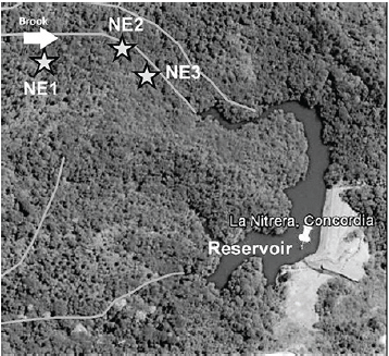
Figure 1 Selected sampling points (Take from Google Earth), where NE referes to each sampling station.
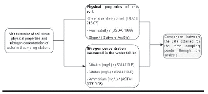
The three sampling stations are near to the La Nitrera stream. This brook feeds a reservoir located in the nature reserve as evidenced in Figure 1. Soil samples were taken from the stream bed walls at each sampling point for further analysis. Additionally, nitrogen concentrations in the form of nitrates, nitrites, and ammonia were measured at the water table level of each station. Figure 2 presents a graphic summary of the methodology used in the field work.
The comparison between the field data is made through a descriptive analysis for each variable results of each sampling site. This was done through an analysis of each point results in conjunction with the behavior of the variables reported in the literature.
3. Results and Discussion
3.1 Grain size distribution.
According to the samples recovered at each site, Table 1 shows the results of the soil grain size distribution according to the Unified Soil Classification System (USCS) in accordance with the ASTM standards.
Table 1 Soil classification by stations according to USCS.
| Station | Pass through sieve N°4 (%) | D10 | D30 | D60 | C u | C c | Criterio n | USCS Classification | W (%) |
|---|---|---|---|---|---|---|---|---|---|
| NE1 | 54 | 2.2 | 11.8 | 316.7 | 145.5 | 0.2 | Cu<6.0 y/ó [Cc<1.0 ó Cc >3.0] | SP | 64.8 |
| NE2 | 88.5 | 1.3 | 1.5 | 17.3 | 13.6 | 0.1 | SP | 97.1 | |
| NE3 | 86 | 1.1 | 2.2 | 4.2 | 3.8 | 1.0 | Cu≥6.0 y 1≤Cc ≤ 3 | SW | 46.7 |
According to the results of Table 1, it is shown that the three stations are of sandy granulometry. More specifically, stations NE1 and NE2 are within the group SP (poorly graded sands) and station NE3 is classified within the group SW (well-graded sands). Both groups (SP and SW) tend to have low fines content.
As a result of obtaining soils with predominantly sandy texture at the three sampling sites, nitrates would be expected to be easily leached by the rainfall water. The above is because sandy soils, having a lower water retention capacity, have a much higher nitrate leaching potential compared to fine-grained soils (O'leary, Rehm and Schmitt, 1989; González, González and Mardones, 2003).
3.2 Infiltration rate
The infiltration rates obtained are 1.23, 0.39, 0.97 cm / min for E1, E2 and E3 respectively. According to these results, the infiltration rate is classified according to IGAC as very fast (> 0.42 cm/min) for stations NE1 and NE3 and fast (0.21-0.42 cm / min) for NE2 (Montenegro & Malagón 1990). The fundamental relationship between infiltration rate and moisture is that when sandy soils are saturated, they tend to conduct water at a higher rate than when they are free of moisture. This is due to the difficulty that water has to pass through empty pores (Montenegro & Malagón, 1990; Donoso, 1994). This explains the inverse relationship between the infiltration rate and the concentration of nitrates in the water because if there is a good flow of water through the soil, nitrate ions can be easily lost and will not accumulate.
3.3 Nitrates (NO 3 -) Nitrit (NO 2 -), and ammonium (NH 4 +)
The evaluation of the content of nitrates and ammonia reported in Table 2 shows important changes in the results of the nitrate content (values from 0 to 18 mg/L). Table 3.2 presents the values of the concentrations of nitrates (NO3-), nitrites (NO2-), and ammonium (NH4+) according to the different sampling dates for each station. The three forms of nitrogen were measured both in the water of the phreatic level (WT) and in the surface water (ST) of the La Nitrera stream. However, for this study, the analysis of the results focused on the water table.
Table 2 Report of nitrate, nitrite and ammonium concentrations. Concentrations measured in WT (Water table) and SW (surface water).
| Station | Matrix | Nitrates (mg/L) | Nitrites (mg/L) | Ammonium (mg/L) | Samplings | Month |
|---|---|---|---|---|---|---|
| NE1 | WT | 0.6 | 1.0 | 1.5 | 1 | September 2016 |
| NE2 | WT | 12.7 | 0.6 | 0.0 | 1 | |
| NE3 | WT | 1.8 | 0.4 | 0.6 | 1 | |
| NE1 | SW | 0.0 | 0.0 | 0.0 | 2 | December 2016 |
| NE2 | SW | 0.0 | 0.0 | 0.0 | 2 | |
| NE3 | SW | 0.0 | 0.0 | 0.0 | 2 | |
| NE1 | WT | 2.1 | 0.3 | 5 | April 2018 | |
| NE2 | WT | 18.0 | 1.9 | 5 | ||
| NE3 | WT | 4.5 | 0.3 | 5 | ||
| NE1 | WT | 0.0 | 0.0 | 6 | July 2018 | |
| NE2 | WT | 0.0 | 0.0 | 6 | ||
| NE3 | WT | 0.0 | 0.0 | 6 |
For the results obtained in the surface water (SW), the reported nitrogen concentrations were below the detectable limit, therefore, they were assumed to be zero. Likewise, the highest nitrate values were reported in sample 5, corresponding to April, as well as the concentrations of sample 1, corresponding to September.
Temporal variability in nitrate concentrations may be related to the sampling rainfall season. The months of April and September usually tend to have the highest rainfall of the year in the study area, which favors nitrate washing. However, the month of July presented nitrate concentrations at the water table in the order of 0 mg / L, because it is the month with the lowest levels of precipitation compared to April (IGAC, 2007).
The above suggests variability in the results according to the date of sampling. However, according to the variance components analysis in Table 3, there is higher variability between nitrate and ammonium concentrations due to spatial change. When nitrate concentrations were reported, ammonia concentrations were also reported, because ammonia is a source of nitrates. On the other hand, nitrate ions tend to be more unstable and oxidize easily when sufficient oxygen conditions exist in the medium (Mejía, 1963). These conditions are fulfilled by the study area as it is a soil with a high content of sands and organic matter favors its aeration.
Table 3 Analysis of variance components for nitrogen in water. The error shown in the table corresponds to the error obtained from applying the test of variance only between Sampling and Station.
| Variable | Sampling | Station | Metrix | Error * |
|---|---|---|---|---|
| Nitrates (mg/L) | 0.00 | 52.71 | 0.00 | 47.29 |
| Nitrites (mg/L) | 19.82 | 0.00 | 0.00 | 80.18 |
| Ammomum (mg/L) | 0.00 | 62.25 | 0.00 | 37.75 |
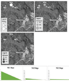
Table 3 also shows a pattern in the nitrate concentrations, where the concentration is higher in station 2 and lower in station 1. In order to explain the behavior according to the sampling location, Figure 3 shows the variable's average values for each sampling station. NE2 presented the highest nitrate value, and between NE1 and NE2 the most significant slope change occurs. Therefore, nitrates are carried from NE1 to NE2 by the action of the ground slope, which is higher in NE1 compared to NE2. Subsequently in NE2, the nitrates could be concentrated for a longer time due to the low changes in the slope between NE2 and NE3. Between NE2 and NE3 the lowest infiltration rate is presented concerning the other stations, which would prevent nitrates from being quickly carried to the other sampling station.
3.4 Influence of geomorphological conditions on nutrient flow through the soil
The slope of the ground becomes important to explain the nitrate concentrations in the water phreatic level. Because due to the variability provided by the spatial dimension in the analysis of nitrate ions, it is suggested that the variability in nitrates cannot be explained by the soil grain size distribution of each station due to evidenced soil homogeneity in the three sampling stations. Therefore, the slope and the speed of infiltration are the variables that help to explain the flow of nitrates from the soil pro-file, since they are closely related to their loss due to runoff and infiltration.
The cross-section in Figure 4 shows the sloping ground of each sampling point, where station 1 (NE1) presented the lowest concentration of nitrates and presented the highest ground slope of the three sampling sites. Therefore, it is inferred that the Nitrates on NE1 are easily carried away by the water runoff and it's accumulated at NE2 where the slope decreases significantly. However, in NE2 and NE3 an inclination of 0.5 ° is reached, which could indicate that between these stations the nitrate washing due to runoff is not very significant due to the decrease in the ground slope. Therefore, the above explains the tendency of nitrates to concentrate on station 2 more than in the other stations, as illustrated in Figure 4.
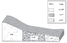
Figure 4 Influence of the slope on the flow of nitrates in the water of the water table. Where [NO3-] corresponds to nitrate concentrations in to NE1, NE2 and NE3 respectively.
In addition to the grain-size distribution influence, the ground slope also plays an important role in the internal drainage process. As it was explained by Thiers & Gerding, (2007) the brooks located at high elevations and with a high slope, act to the detriment of the mineral soil depth and favor the internal drainage. Therefore, the high concentration of nitrates in NE2 is influenced not only by external drainage but also by the internal drainage, as it was shown in NE1, since it presents the highest slope of the three sampling sites. Finally, nitrates tend to remain in the liquid phase of the soil and do not precipitate like other minerals, traveling great distances on a permeable sediments or the surface of groundwater (Pachecho and Cabrera, 2003).
4. Conclusions
According to the obtained results, it is suggested that the measured variables (ground slope, granulometry, and infiltration speed) explain the behavior of the nitrates. However, the ground slope plays an important role because the water movement through the soil is largely influenced by the shape of the ground. Therefore, the nitrates are easily carried by the water rate and by the temporal variability according to the rainfall regimes. Finally, the rainy season also influences the nitrates concentrations in the water table due to the increased probability of nitrates being washed out by runoff or leaching.

