


Servicios Personalizados
Revista
Articulo
 texto en
  Español (pdf)
 Articulo en XML
 Referencias del artículo
 Enviar articulo por email
Indicadores
-
 Citado por SciELO
 -
 Accesos
Links relacionados
-
 Citado por Google
 -
 Similares en
SciELO
Similares en
SciELO -
 Similares en Google
Compartir

 Permalink
Revista Criminalidad
versión impresa ISSN 1794-3108
Rev. Crim. vol.62 no.1 Bogotá ene./abr. 2020
Criminological studies
Contributions of complexity for the understanding of the dynamics of violence in cities. Case study: the cities of Bello and Palmira, Colombia (Years 2010-2016)
1PhD en Ciencias Humanas y Sociales Docente, Escuela de Ciencias, Artes y Humanidades Universidad Nacional Abierta y a Distancia Eje Cafetero, Colombia williams.jimenez@unad.edu.co
2PhD en Ciencias Económicas Docente, Escuela de Ciencias Básicas, Tecnología e Ingeniería Universidad Nacional Abierta y a Distancia Bogotá, D. C., Colombia rafael.renteria@unad.edu.co
There are varied studies that attempt to explain violence in Latin American cities, most approached from a single disciplinary field such as sociology and criminology. This article tries, from the perspective of complexity, to provide tools that allow us to understand the dynamics of violence in urban contexts. The nature of the study is quantitative; this is a case study that compares the homicides of two intermediate Colombian cities. For this, the database that compiles the National Police of Colombia through its statistical system was processed, the data of the 2010-2016 time window was spatialized, hotspots maps, where we could evidence the distribution of homicides in certain sectors of the cities studied were created and, finally, topological metrics that allowed us to visualize patterns of these violent events were performed. Among the important findings that were obtained through this methodology are (1) that the distribution and diffusion patterns are very different in space and time because the topological evolution of the subgraphs that compose the complex networks of the systems studied follows different behaviors despite having a series of similar social, economic and environmental variables; (2) that homicides tend to concentrate and coincide with the centralities of the cities studied; and (3) that the tools of complexity, as well as interdisciplinary studies, are innovative and useful for understanding the dynamics of urban violence.
Keywords: Violence; homicide; criminal statistics; crime trends; crime statistics
Son variados los estudios que intentan explicar la violencia en las ciudades latinoamericanas, la mayoría abordados desde un único campo disciplinar como la sociología o la criminología. El presente artículo intenta, desde la perspectiva de la complejidad, aportar herramientas que permitan comprender las dinámicas de la violencia en los contextos urbanos. El carácter del estudio es cuantitativo; este es un caso de estudio que compara los homicidios de dos ciudades intermedias colombianas. Para ello se procesó la base de datos que recopila la Policía Nacional de Colombia por medio de su sistema estadístico, se espacializaron los datos de la ventana temporal 2010- 2016, se crearon mapas hotspots donde se evidenció la distribución de los homicidios en ciertos sectores de las ciudades estudiadas y, fi nalmente, se realizaron métricas topológicas que permitieron visualizar patrones de estos eventos violentos. Entre los hallazgos importantes que se obtuvieron con esta Metodología están (1) que los patrones de distribución y difusión son muy diferentes en espacio y tiempo porque la evolución topológica de los subgrafos que componen las redes complejas de los sistemas estudiados sigue comportamientos diferentes pese a tener una serie de variables sociales, económicas y ambientales similares; (2) que los homicidios tienden a concentrarse y coincidir con las centralidades de las ciudades estudiadas; y (3) que las herramientas de la complejidad, así como los estudios interdisciplinares, son innovadores y útiles para comprender las dinámicas de la violencia urbana.
Palabras clave: Violencia; homicidio; estadísticas criminales; tendencias del delito; estadísticas criminológicas
São variados os estudos que tentam explicar a violencia nas cidades latino-americanas, a maioria abordados de um único campo disciplinar como a sociologia ou a criminologia. O presente artigo tenta, da perspectiva da complexidade, fornecer ferramentas que permitam compreender as dinâmicas da violência nos contextos urbanos. O carácter do estudo é quantitativo; este é um caso de estudo que compara os homicídios de dois cidades intermédias colombianas. Para isso foi processada a base de dados que coleta a Policia Nacional da Colômbia por meio do seu sistema estadístico, se especializaram os dados da janela temporária 2010-2016, foram criados mapas hotspots onde foi evidenciada a distribuição dos homicídios em certos setores das cidades estudadas e, finalmente, realizaram-se métricas topológicas que permitiram visualizar padres destes eventos violentos. Entre os achados importantes que foram obtidos com esta metodologia estão (1) que os padrões de distribuição e difusão são muito diferentes em espaço e tempo porque a evolução topológica dos subgrafos que compõem as redes complexas dos sistemas estudados segue comportamentos diferentes apesar a ter uma série de variáveis sociais, econômicas e ambientais similares; (2) que os homicídios tendem a se concentrar e coincidir com as centralidades das cidades estudadas; e (3) que as ferramentas da complexidade, assim como os estudos interdisciplinares, são inovadores e úteis para compreender as dinâmicas da violência urbana.
Palavras-chave: Violência; homicídio; estadísticas criminais; tendências do delito; estadísticas criminológicas
Introduction
Violence can be classified as a phenomenon of a multidimensional nature because although it is basically the violent social practices that define it, the acts that are considered violent are so diverse in their impacts and consequences, as well as in their origins that it is almost impossible to refer to violence as an object of unique, particular or singular study. In other words, for the establishment of tracer elements that allow to understand, evaluate and monitor violence, it is required to consider particular aspects of each territory and of the more extensive psychosocialcontext because, among other things, emerging effects result from such different causalities that classical statistical descriptions, sociological interpretations or psychological diagnoses which fail to describe in accordance, are particularly used in a disaggregated way.
In that sense, rises the need to involve methodological approach studies that allow the generation of synthetic approaches without affecting the interactions of the situational components of the territory under study. For this reason, complex thinking becomes the ideal methodological approach to study the space-temporality of violence in one or more territories.
For Edgar Morín (1999), complex thinking is a proposal to reform current thinking, whose ability to relate the paradoxical and inconceivable faced with uncertainty and its emergencies, is viable through a dialogic rationality in which life, nature and thought intercommunicate. Along this same line, Martos (2015, p. 13) states that complex thinking is used in researches “in a narrower sense, to designate scientific studies that attempt to explain the complex dynamics of the objects under study, without extracting from it more general cosmo-visual or methodological consequences”.
In this sense, the present investigation is based on the paradigm of complex thinking in that the investigation is of a relational type (far from traditional Cartesianism), so, before rejecting a research hypothesis, the contradictions of reality and chance that we try to explore are integrated and overcome, something like what expressed by Morín (1999), through dialogic processes where the epistemological complexities and doubts of the certainties of knowledge are included (Morín, 1997).
From this definition, then you understand that through the use of the paradigm of complexity it is possible to reach the presumption of building and consolidating an investigation object a little more reliable and that allows being exhausted from the analysis of various disciplines. This ethical implication seeks to contribute to the valuation of the properties exhibited by a complex system; examples of this premise are in the contribution of physics and everything related to the study of fields and particles that can be used for some social studies; for example, Edmonds and Meyer (2013) present a series of methods of physics to study factors such as persuasion and resilience, among other social processes that turn out to be dynamic over time. As for what corresponds to violence and crime, the focus of studying complex systems that stands out are complex networks. These are useful to represent the interaction of territorial variables in the space-temporality of the crime, as presented by some studies of D’Orsogna and Perc (2015) and Papachristos (2009), which allowed to study from a perspective system the complexity of urban violence in aspects such as interaction of illegal groups such as gangs and gangs with some of the crimes or homicides, distribution of temporal patterns of crime in different territories.
The foregoing allows a space-time analysis of violence (represented by the homicide variable) to be considered for the present investigation, using tools of complexity sciences, particularly topological metrics, in two Colombian municipalities with high rates of homicides and are suburbs to two of the largest cities in Colombia, which in late 1980 suffered the impact that generated the today extinct drug cartels of Cali and Medellín.
In this sense, the present study has as a general objective to establish the territorial relations that are embodied in a defined geographical space such as the city to understand the violent social practices produced by homicides. The aforementioned, based on the hypothesis that homicides are not distributed homogeneously in the territories nor in a random manner, meaning that, they occur due to an intentionality that arises from a rationality of exploitation of the rents of a territory.
Current Situation
It is not possible to determine an exclusive linear or causal relationship between violence and the city, what does not mean that there is no interaction between the two. In the city not only violence is contained, it reproduces, sometimes its inhabitants can cause it and in others suffer its effects. The relationship between city and violence can be found when the former is understood as a scenario of social relations (Carrión, 1993) and the latter as a particular conflict relationship presented in this scenario (Guzmán Barney, 2007) .
It can be stated that in Latin America there is a historical relationship between the city, its rates of urbanization and violence (Gaviria & Pages, 1999; Vargas & García, 2007). The foregoing does not limit violence to circumscribe in the city; in fact, there is rural violence, but what can be noted is that there is a differentiation of the type of violence between the two contexts, were according to Duncan (2005) in the countryside crimes against persons, family and moral take precedence and in the city crimes against property.
In the study of Churruca (2014) it is evident that the mass migration from rural to urban areas in Latin America generated a situation which allowed the confrontation and social conflict; according to Jiménez García (2013, p. 64), “more people than the territory could have, the Government could attend and society could tolerate, arrived”. This human displacement generated an increase in rates of urbanization in the cities and in crime rates, as in the city (1) more wealth is concentrated and therefore the means are diversified to obtain and compete for it (Perea, 2016); (2) higher amounts of risk accumulate (Chardon, 2008); (3) it produces the marginalization of broad sectors of human groups (Petrella & Vanderschueren, 2003); (4) there is greater pressure for social recognition (Del Olmo, 2000); and (5) the bonds of solidarity that were brought from the countryside are diluted (Guzmán Barney, 2007).
Latin America has become a continent of cities; its accelerated urbanization has coincided with the increase in homicide rates (Carrión, 2008). There are several explanations that research has offered to this relationship of urbanization and violence: For Briceño-León (2002) the migratory dynamics from the countryside to the city in most Latin American countries not only explains the acceleration of urbanization, but also the increase in violence, since the city is the scenario where conflicts and competences for goods and services arise (Cocco & Lopes, 2010).
However, the population explosion does not generate violence by itself according to Martin (2012); the Latin American urbanization process is related to violence in the sense that this disorganized and unplanned growth has led to deep problems of coexistence and marked social resentment among the most marginal groups (Rotker, 2000; Vargas & García, 2007). This urbanization process without articulation, governed by the logic of power and territorial control, characterized by the lack of balance and equity (Briceño-León, 2007) has propitiated in Latin American cities a whole social order that recognizes in violence a medium which guarantees survival in the city (Kessler, 2004), either using it against some other individual or adapting to it.
In turn, the socio-spatial segregation (Caldeira, 2011; Paternain, 2006) is caused partially by the migration from the countryside to the city and the socio - economic conditions of cities in general (rather than individual ones), generating sites, dangerous and insecure areas and neighborhoods (Bordsorf, 2003), where violent criminal acts hatch (Jiménez García, 2014).
Since the mid-nineties, several ecological crime studies have attempted to find the political-institutional and socio-economic factors that are configured in urban settings where there are high rates of violence in Latin America, comparing the distribution of homicides in different aggregate units: countries, regions, provinces, departments, metropolitan areas, municipalities, cities, communes and neighborhoods (Beato, Peixoto & Andrade, 2004; Dammert & Lunecke, 2004; Jiménez García, 2016).
From econometrics and multivariate analysis, the study made by De la Fuente Mella, Mejías and Castro O’Kunighttons (2011) determined how some explanatory variables such as poverty, schooling, drug use, inequality and even the model of household leadership influenced the behavior of violent crimes against property .
The study of Villarreal and Silva (2006) is illuminating as it empirically proves sociological theories of crime on a defined territorial scale: the neighborhood. In this research the effect of the structural characteristics of the neighborhood in the social cohesion of the inhabitants and the production of crime in this political and cultural area. The study was based on a multilevel design and the data was collected through a survey in a community in the city of Belo Horizonte (MG). The main conclusion of this study focused on affirming the existence of poor neighborhoods of dense networks and high levels of homicide constitute an epistemological challenge for theories of social disorganization, results that are similar to those found by Manzano (2009) in slums of Santiago de Chile.
In the same line, the study Escobar (2012) developed in neighborhoods of Bogotá using spatial data analysis found that the concentration of social disadvantages, social-spatial segregation, social disorder and the presence of formal institutions of social control can predict high levels of violence in some neighborhoods of the Colombian capital. However, he also found that proxy variables such as sex and the age group (specifically young men, between the ages of 17 and 25) did not explain much of the homicides of the most dangerous neighborhoods in Bogotá, what means that for these neighborhoods, the existence of criminal structures such as urban militias, youth combos and gangs, do not have such a strong impact, as stated in other studies such as González and others (2012), but there are other elements such as social disadvantages which can explain in a more complete way the homicidal situation that is present in these neighborhoods.
Materials and methods
The present study is designed from a quantitative research approach with different levels of analysis (city and neighborhoods). It answers a problematizing question that seeks to study the joint variability of space and time to predict or generate crime scenarios: focusing geographic areas of insecurity and determining vulnerable groups to suffer criminal acts. For this, the results of the criminal statistical information that the Colombian National Police builds were analyzed. The analysis is of a statistical-relational type with the use of complexity theory, a fact that makes it correlationalexplanatory, since it seeks to know the relationship between variables and understand the meaning of such relationship.
The case study
The search to produce knowledge that is useful to understand phenomena that affect the urban areas of Colombia demanded, in a first stage, to select cities that were representative of the cities of the region. The elements that were taken into consideration were their characteristics of population, social indicators and levels of violence.
Methodologically, it was determined to use two conditioning criteria, the first was related to the fact that they are intermediate cities, as in Colombian investigation of the phenomena of violence abound investigations of the cities of Cali (Valle de Cauca), Medellín (Antioquia), Bogotá (Cundinamarca) and recently Barranquilla (Atlántico) and little is known about the intermediate cities or suburbs of these cities such as Bello and Itagüí (Antioquia), Palmira and Yumbo (Valle del Cauca), Soledad and Puerto Colombia (Atlántico) or Soacha (Cundinamarca). The second criteria was the application of a method of differences in comparative studies, known as Most Similar System Design (MSSD) that seeks to compare similar units (intermediate cities) in their components and different in their results (Anckar, 2008) . Thus, the selected cities were Bello (Antioquia) and Palmira (Valle del Cauca).
The two cities have elements in common that should be highlighted. The two populated centers (1) have high urban growth rates; (2) receive a large number of people displaced by violence, but also of local immigrants who arrive seeking better economic opportunities (National Planning Department, 2012); (3) have a particular strategic location that stimulates and encourages the configuration and operation of illegal markets, especially that of drugs (Cortés, Gómez & García, 2015): (3.1) Bello is located in the road node that connects the Valle de Aburra and southern Antioquia with the main centrality of the country, Bogotá; (3.2) Palmira is located next to Cali and is part of a large agro-industrial center in the country; besides, it is found in a point connecting the port of Buenaventura, at the Pacific Ocean, with Andean regions as the Eje Cafetero and the Cauca.
The techniques: Topological Networks and their spacing
This study adds to the growing number of academic papers that make use of complex networks to explain multi-causal phenomena such as violence. First, the spatial relationship of homicide in each of the municipalities is presented and then, secondly, to show its space-time relationship.
The dataset comes from the Observatory of the Crime of the National Police of Colombia, which is the research area of this entity that is responsible to collect, process, analyze and evaluate information for the homicides applying criminological science (National Police Colombia, 2017b). This set contains information of the homicides in the municipalities of Bello and Palmira during the years 2010-2016, describing variables such as police station, date, time, neighborhood, kind of place, weapon, characteristics of the victim and characteristics of the victimizer. The Police collect this information thanks to a legal mandate that confers such responsibility and based on internal protocol that validates the data processed here.
The data set constructed from the information provided by the Police contains 2166 records, each with 15 variables that describe the violent act. Information that was collected in the field by personnel of the National Police of Colombia, the Colombian Institute of Legal Medicine and other institutions of criminological profile, such as the Attorney General’s Office.
For the construction of this model, two computational tools were used to answer the fundamental questions of this research. Qgis was used to present the special graphics. However, all spatial statistical analyzes were developed in Python through the Geopandas, Shapely and scipy.spatial packages. For representation of hotspots Kriging models were especially used.
As for the networks, in this study tools belonging to complex networks are use from the perspectives of Strogatz (2001), Dorogovtsev and Mendes (2003), Estrada and Rodríguez-Velazquez (2005) and Newman (2010). Complex networks can be understood as sets of many connected nodes that have some interaction. The nodes are called vertices or elements and are represented with symbols such as v1, v2, ... vN, where N is the total number of nodes in the network. If a node vH connects to other node vS, this connection is represented by an ordered pair (vH, vS).
A network represents a system through its components and the relationships that are configured between them. The network can be mapped using a graph A (V, E), with V the set of vertices v ∈ V and E the set of edges or links between vertices. This methodology has been widely used to investigate natural, social and artificial systems, such as social cohesion and victimization (Rentería-Ramos & Soto, 2016), the optimum of criminal networks (Sarmiento, Cantillo, Realpe, & Montoya, 2016), design and planning of intelligent surveillance networks (Relanzón, 2009), measures of police performance through complex networks (De Oliveira Muniz & Proença Júnior, 2005) and lifestyles and health (Pastor-Satorras & Vespignani, 2002).
Inside the applications of criminology that have used complex networks, Papachristos (2006, 2009, 2014) works stand out, who uses network analysis to study the criminogenic dynamics of gangs, criminal and delinquent gangs in a territory. A particularity that these investigations have is that for the construction of the networks, the nodes represent people who belong to the different illegal groups, and the edges are framed in social relationships that represent social conflicts such as aggressions and territorial disputes (Papachristos 2006, 2009, 2014). This type of studies has managed to find even endogenous factors that explain in greater detail the criminological dynamics of the territory, for example the patterns of retaliation, as well as alliances (between certain groups) to subordinate the strongest; They are subject to conditions of space and time. Despite having the same actors and patterns and the same variables in all territories, with the results obtained by Papachristos, Hureau and Braga (2013) it is inferred that these come from an adaptive and evolutionary dynamic of the variables, which were not explained as one of its simple parts .
Davies and Marchione (2015) propose a network model to study the spatial-temporal patterns of criminological events by illegal actors. The central idea of this research work is the configuration of the factors that favor the patterns of criminogenic events taking into account the co-occurrence of space and time. Because of that, for the design of this network, nodes defined as the geographic locations where the events occurred, and the edges are the co-occurrence of events in time, in certain geographical radios. For this reason, the subgraphs that make up the network become the main information to find the most significant configurations in the appearance of the criminogenic patterns of the territory. These subgraphs are known as motifs, they are characterized for being elements with low levels of entropy in the circulation of their information; therefore, their interactions and their flows can be considered as causal elements Thus, for this investigation a process similar to that proposed by Davies and Marchione (2015) will be carried out, a complex network will be considered where the nodes will be the spatial locations where homicides occur, and the edges are the co-occurrences of these in a mobile window of time. For detection of motifs cliques detection algorithms will be used (a type of subgraph in which all nodes interact with each other) based on the Kumpula et al. (2008) algorithm. One of the inconveniences of working with subgraphs of a network is its granularity, which can be a difficulty in prioritizing zones. Therefore, it is necessary, in addition to cutting the cliques with high statistical significance for the pattern configuration, to build assemblies of these to obtain a multidimensional approach to this phenomenon in the territory. The incorporation of algorithms was needed, the first of which refers to measures intensity and coherence of motifs of Onnela et al. (2005) to assess the statistical significance of the subgraph and the subgraphs assembly algorithm of Fortunato (2010). In the representation of results, the colors of the edges reflect the application of the algorithms previously mentioned; meaning the same colors reflect nodes motifs with high levels of intensity and coherence and the various assemblies existings between them.
Diagnosis of the homicide network in the two cities studied
After debugging the database of the National Police of Colombia and selecting the variables to study, for the case of this study are time (time of the murder) and space (neighborhoods), which will be known from now henceforth as the nodes of the network, the homicide relationship with the geographical spaces where they were perpetrated was evidenced, following a basic scheme, where B1, B2 and B3 represent neighborhoods in which some homicide was committed in the times t1, t2, t3. These numbers s represents n simultaneity (time distribution) of the homicide. Then B1, B2 and B3 represent neighborhoods. The strength of the links Wij defined by the formula.
Wherek is the time of the murder and j is the place where it happened. The greater the number of homicides at a given site or time, the greater the strength of the relationship between the variables.
Intensity and coherence analysis
In complex networks, the motifs show interconnection patterns with frequencies much higher than those graphs that study random situations. These types of studies or analyzes have been used in works such as those by Delmas et al. (2017) and Rodríguez-Rodríguez, Jordano and Valido (2017). Motives or coherence have intrinsic characteristics that determine the probability of occurrence of certain values in the nodes, despite its application to particular sections of the network (De Oliveira Muniz & Proença Júnior, 2005). This fact allows a generation of a series of trends in information that allow visualizing elements such as the consensus of the nodes that configure the addresses and magnitudes of these relationships in the network. This condition is essential to understand the topology of crimes and also to find patterns of homicides in the territories. To introduce topological aspects of motifs in weighted networks (or force), the use of intensity and coherence metric developed by Onnela et al. (2005) takes pace. This methodological model, intensity I (g) for the graph g with vertices Vg and the edges l g as the geometric measure their weights Wij or their strong points is given by the following equation:
This formula guarantees the qualification of the link in the coherence of the Wij values and leads to prioritize the neighborhoods where there are more coincidences in the homicide time-space. From there, coherence Q (g) is set, which allows studying the consensus of the variables at the edges of the motives. Coherence takes values close to the most important unit for its graph to establish the association between a set of neighborhoods, is defined as the relationship between intensity I (g) and the geometric mean of its weights or strengths Wij, as presented in the following equation:
Results
Homicide statistics in cities
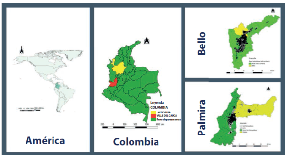
The cities selected for this study were Bello (Antioquia) and Palmira (Valle del Cauca) (figure 1). Bello has 482,287 inhabitants (DANE, 2016), the largest population after the city of Medellín, in the metropolitan area of the Valle de Aburrá, in the westcenter of the country. On its behalf, Palmira is the second most populous city (310,594 people -DANE, 2016-) in the metropolitan region of the southern Valle del Cauca (not a legally constituted metropolitan area), in the southwest of Colombia.
These cities have similar criminal dynamics from a national and regional perspective, but different from the municipal, local and even micro-local perspectives. For purposes of this study, the behavior of homicides will be analyzed comparatively for each of the two cities. During the study period, in the two cities there were 2166 homicides, 31.35% in Bello and 68.5% in Palmira (figure 2). Although Palmira is a less populated center than Bello, in the fi rst more murders were committed year after year. These tend to go descending in Palmira and are rising in Bello.
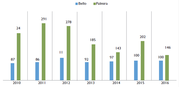
Source: Own elaboration with data from the National Police of Colombia (2017a)
Figure 2 Homicides registered in the cities of Bello and Palmira, years 2010-2016
Regarding the homicide rates, which allow us to understand the impact of this crime faced to the society that receives it and compare the reach it has in the two cities, the highest was that of Palmira, which in some cases exceeded even by four times the one of Bello (figure 3). Palmira’s was always higher than the national one (Colombia); Bello’s, except for last year (2016), was always below (figure 3). It is also necessary to indicate that both cities exceeded the limit set by WHO, which categorizes homicide in the territories as a pandemic (Franco, 1999).
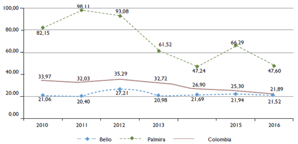
Source: Own elaboration with data from the National Police of Colombia (2017a) and population-based calculations
Figure 3 Homicide rate of the cities of Bello and Palmira, years 2010-2016
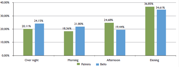
If the year-on-year behavior of homicides is observed by city, for Palmira 2011 was the most violent (292, rate: 98.11) and when there were the least was in 2014 (143, rate: 47.24). In Bello, the year with the most violent deaths was 2012 (117, rate: 27.21); otherwise occurred in 2016 (92, rate: 21.52. Figures 2 and 3). As for the time of day (temporary), more homicides were recorded in both cities at night, followed by the afternoon and early morning (figure 4).
Source: Own elaboration with data from the National Police of Colombia (2017a)
Figure 4 Days in which homicides were committed in the cities of Bello and Palmira
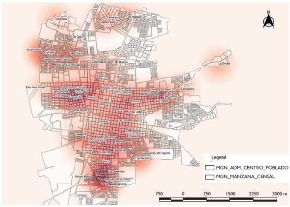
On the other hand, in order to fi nd the spatial relationships of crimes in geographical spaces, GIS tools were used, particularly hotspots. To make the map of homicide hotspots, a method known as Kriging was applied. To apply this technique it was necessary to previously perform three tasks: (1) determine the dependent and independent variables, which in the case of this were homicides; (2) collect homicide data through the aforementioned database; and (3) make the predictions by using free software Qgis
In the case of Bello, the neighborhoods with the highest number of homicides concentrated were Ciudad Niquía (54, 9 on average per year), Zamora (42), La Cabaña (27), Niquía Camacol (27), Medellín - Bogotá Highway (25) Gabriela (25), Prado (21), Par í s Central (19), Vereda El Pinar (18), Maruchenga (17), Vereda San Félix (17) and El Cóngolo (13). If the concentration of homicides is observed, it is evident that three axes are generated (figure 5): (1) in the north of the city with the neighborhoods Altos de Niquía, Niquía Camacol, Niquía Quitasol, Niquía Bifamiliar and Ciudad Niquía; (2) in the center, which particularly concentrates the largest number of homicides, the Central, Prado, Pérez, La Mesa, Cóngolo, El Carmelo, Las Farjas, Cairo and Manchester neighborhoods are located; and (3) in the south on the border with Medellín and at the beginning of the Highway to Bogotá, with the neighborhoods La Madera, La Cabañita, Acevedo, Zamora and Santa Rita.
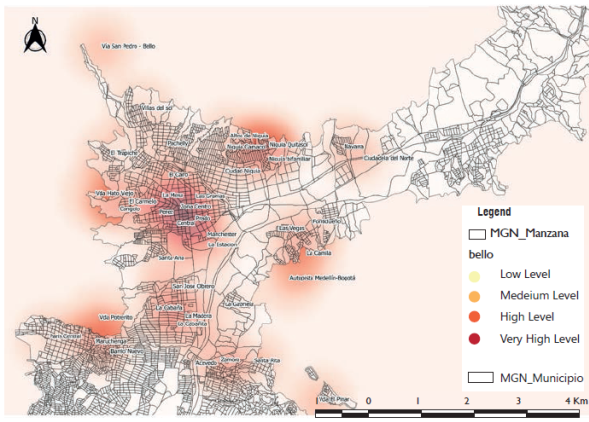
Source: Own elaboration with data from the National Police of Colombia (2017a)
Figure 5 Homicide Hotspots in Bello
In the case of Palmira, there were four neighborhoods with more than one monthly homicide (something that is actually alarming). In Zamorano (79), San Pedro (76) and La Emilia (72) two monthly and in Las Delicias (60) two quarterly. Other neighborhoods that have a high number are: Loreto (44), Central (36), La Trinidad (34), Corregimiento de Rozo (31), Coronado (31), Colombia (29), Sembrador (26), Villa Diana (24), Caimitos (21), Colombina (21), Sesquicentenario (21), Barrio Nuevo (20), Harold Eder (20), La Odilia (20), Simón Bolívar (19), Alfonso López (18), Campestre (17), El Prado (17), Ignacio Torres (17), San Cayetano (17) Los Dolores (16) Corregimiento NuevaTienda (15), Danubio (14), Olímpico (14).
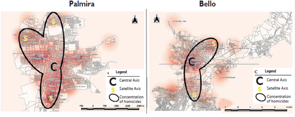
As for the concentration, in Palmira a particular fact was found: most of them were perpetrated in the center south area of the city, which runs from the neighborhoods of Llano Grande (center west) to Campestre (center east) (figure 6). In this axis almost 70% of the murders concentrate. Additional to this, there are other three: the fi rst, in the northwest (figure 6), in which neighborhoods Hugo Varela, Caimitos, Ignacio Torres, Portal de las Palmas and Villa Diana are located; the second, in the north (figure 6), with the neighborhoods Harold Eder, Los Mangos and Zamorano (in which the majority of homicides concentrated in the study period); and the third, in the south, comprising the neighbourhoods of Petruc, Las Americas, Sesquicentenario, Parque La Italia and Simón Bolívar (figure 6).
Source: Own elaboration with data from the National Police of Colombia (2017a)
Figure 6 Homicide Hotspots in Palmira
If maps 2 and 3 of homicide hotspots are observed you can see a graphic-space similarity: In each of the two cities there was a centrality that agglutinated the majority of the deaths and some satellite axes located at the ends of this core (figure 7), indicating, at least morphologically speaking, (1) that there is a distribution in the concentration of murder that can be simile within each of the cities; and (2) that these crimes are gathered in a centrality that communicates with each of the satellites. In other words, this centrality can infl uence the criminal dynamics of each satellite.
These fi ndings coincide with the results of other investigations, for example, the analyzes by Vozmediano and Sanjuán (2010) in their study of the distribution of crime in the Basque Country. They found that homicides and crimes against life tend to group up in the cities’ centralities. This concentration is multi-causal, that is, it does not only obey the natural concentration of capital and resources that an urban centrality contains (Manzano, 2014), but there are other elements, such as the anonymity for the offender that offers the city center (Caldeira, 2000); the diversity of capitals and people who mobilize in the centralities, which increase the opportunities of the criminal (Kessler, 2004); the urban distribution and equipment of the center, which allow both the success of the offender and the constant presence of victims and consumers of the products and services provided by some criminal actors (Bergman, Kessler, & Kessler, 2008) .
In addition, a kind of satellites that are connected to these centralities are generated, mainly due to two situations: (1) that in the peripheries of cities (meaning, of the centralities) pacts generated by criminal organizations to control their income in their territories, both with other organizations and with the legitimate control institutions, are highly effective and do not require a volume of homicides (they do of violence) as high (Briceño-León, 2002); and (2) to the extent that homicide increases in these sectors, the attention of the public opinion is called and alarms are generated, that control institutions, despite the pacts woven with criminal organizations, are requires to act, producing the increase or of clashes and therefore homicides (Jiménez García, 2018). In both cases, the numbers of homicides do not tend to be higher than the ones occurred in the centrality.
These two facts could justify other investigations in other intermediate cities, so that it is checked whether in the intermediate cities there is a pattern in the distribution of homicides such as the one that could be evidenced in the present investigation in each city.
Discussion of results
Space-time approaches for systemic understanding of homicides
When applying an analysis of topological metrics, we try to analyze the spatial-temporal distribution of homicides in order to understand elements such as simultaneity and spatiality in order to fi nd patterns of organization. This allows us to affi rm that murder is not distributed randomly in the territories where it is committed; in fact, it recognizes that this crime is premeditated violent social practices mediated by a series of circumstances that range from the capture of criminal income produced by a territory, including as a mechanism for controlling income production habits in a territory, to a mechanism of production, maintenance and accumulation of power in a territory.
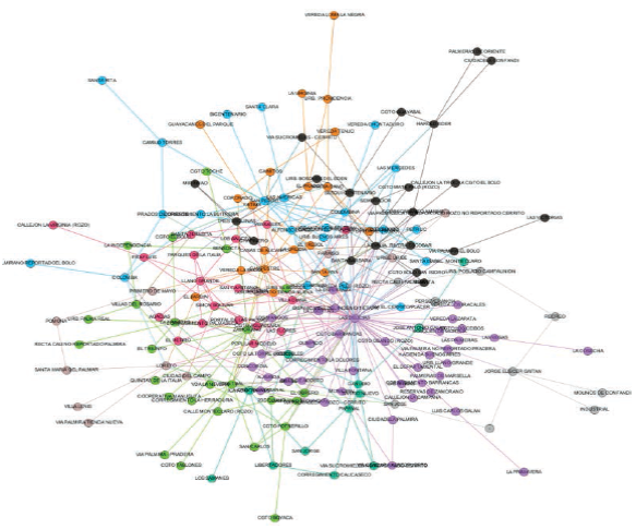
In this sense, the following topological network of homicides in each of the two cities studied allows (1) to defi ne the behavior of homicide in it; (2) understand the logic of occupation and use of spaces by criminal actors; and (3) know which are the territories within the city that need special attention, either to promote new police control strategies or to guarantee the presence of the local State in the form of preventive plans and psychosocial assistance to the population that serves as potential victim as well as also for those who are often the perpetrators. In the municipality of Palmira a dense network of homicides showed the connection existing between each of them in every neighborhood. In fi gure 8 it is shown graphically the way each homicide was distributed or geo-chronologically. To interpret this fi gure it is necessary to understand that each point represents a homicide in a neighborhood and that this point connects with other points, basically showing (1) the connectivity that occurs between the homicides of each neighborhood, where the number of connections will show a pattern of homicides, which will be represented by the greatest number of connections that a neighborhood presents, information that will allow to understand the role or transcendence that this neighborhood has for the accumulation of homicides; (2) that the connection between homicides in neighborhoods generates circuits, that is, networks within the network, which for visual effects are represented by different colors. These circuits are known as communities and they indicate the strength of the connections.
For purposes of the intensity of the homicide it was found in Palmira that neighborhoods like La Emilia, Delicias, Zamorano have it at higher numbers (fi gure 8). Intensity is a measure of the statistical signifi cance that these neighborhoods have at the time of understanding the spatiality of the homicide. In other words, the intensity measures how strong is the crime of murder within the community, it is a measure of the impact of the existence of the murder and its simultaneity and is calculated using the geometric mean that results from a multiplier. This data allows us to understand the importance of these neighborhoods in understanding the behavior of homicides. This information is useful if you want to plan operational controls by the police, because at least you would have to plan effective and simultaneous police surveillance in these priority sites. In turn, the number of homicides in these neighborhoods and the related ones that occur due to the simultaneity of these homicides geographically speaking allows to know the intensity and this in turn is a measure of probability that allows to understand, even infer, the behavior of the homicide, as well as the logic of criminal organizations that commit this crime.
Source: Own elaboration with data from the National Police of Colombia (2017a)
Figure 8 Homicide network of the municipality of Palmira, Valle del Cauca
In Palmira, it was possible to demonstrate the existence of multiple communities represented in figure 8 by different colors. Four have a high explanatory power when talking about the distribution of homicides; they are those of purple as centroid in the neighborhood Las Delicias, black with centroid in La Emilia, blue with centroid in Central neighborhood, and green with centroid in Zamorano neighborhood.
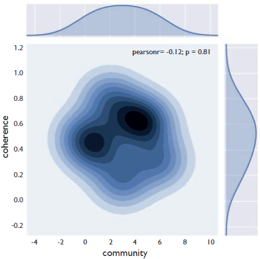
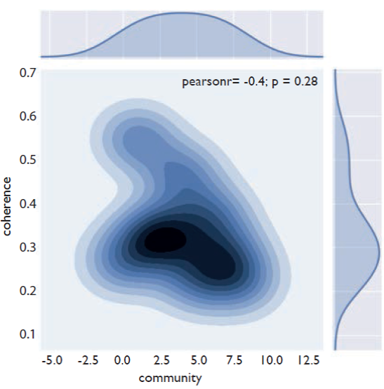
Although the intensity determines the force of the homicide within a geographical space, it is not enough to understand the organizational pattern that the homicide has in a territory, since the intensity is calculated by multiplying two values of homicide existence, what offers a value which may indicate relationships between the homicides of two neighborhoods that are not necessarily connected either spatially or temporarily and therefore do not have an obvious relationship. To solve this situation a calculation is made, known as coherence, which through a statistical yield (the arithmetic means), which makes a relationship between the geometric mean and the arithmetic mean, seeks to understand the state of the flows that are generated in the connections of the nodes . In other words, seeks to determine whether the intensity and strength of the nodes corresponds to events that are logical with reality. In this sense, values close to 1 determine that there is a high coherence in the network and close to 0 that the values have no coherence and therefore are not connected, meaning, they are outside the pattern of the spatial-temporal distribution of homicides.
In the case of Palmira, it was found that there is a coherence of 0,8 (very high), for the communities of Central-Los Mangos 0.60, for those of Las Delicias-La Emilia 0.61, and, 0.64 for the Emilia-Maria Cano, which are the outer rings in figure 9. This result indicates that these neighborhoods concentrate the greatest intensity of crimes and that disconnecting these neighborhoods from the production of homicides would allow the network of homicides to be strategically and systemically attacked.
Source: Own elaboration
Figure 9 Coherence by cliques and homicide communities in the municipality of Palmira, Valle del Cauca.
Meanwhile, in the town of Bello a less dense network than in Palmira was found, because there, fewer homicides were registered (figures 2 and 3). Bello has a very characteristic element and it is clear that the Pachely neighborhood is the central node that connects homicides with all other neighborhoods. In this sense, it could be affi rmed that if effective state control is generated in this neighborhood, an integral reduction of homicides could be guaranteed, since it is attacking the structure that can manage, administer or perhaps control the criminal dynamics of this territory Another particular element that Bello has and that differentiates it from Palmira is there are no neighborhoods where homicides are disconnected from others. That is, all presented simultaneity and therefore connection, there are no isolated cases. This fact is an indicator of the effective territorial control exercised by criminal organizations in Bello, which after consolidating power and managing all the capitals of a territory are responsible for rationalizing the use of violence, particularly homicide. In this sense there is a characteristic, the selectivity of the homicides, there are few, but they generate high impact (it is sought to leave a clear message of territory control). This can also be verifi ed by the decrease in homicides Bello has. In Bello, six communities were recorded (figure 10); the densest represented by the purple cliques, forming an axis in neighborhoods Pachely, Los Alpes, Zona Centro and Suarez. They are followed by the blue network, represented by Zamora- Niquía - Rincón Santo; the green one, made up of neighborhoods like Maruchenga -Ciudadela del Norte- El Paraiso, and in the rural area, the orange one, with places like Vereda de San Félix - Hato Viejo - El Salado.
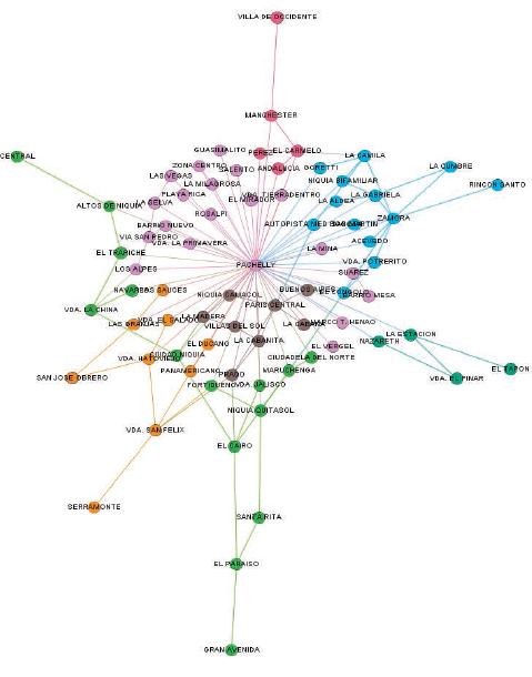
Source: The self-report with data from the National Police of Colombia (2017a)
Figure 10 Homicide network of the municipality of Bello, Antioquia.
Meanwhile, when studying coherence regarding communities and cliques, it was found that its levels are high (0,20 to 0,50) (figure 11). The presence of very high values stands out (0.54) (figure 11) corresponding to cliques represented by neighbor hoods as Zamora, Maruchenga and Pachely and the community represented by purple (figure 7).
Conclusions
According to the literature reviewed, it is possible to evidence and conclude that studies of complex networks have been little used to understand the spatial-temporal dynamics of crimes and in particular of homicides. The present study is just a preamble both to understand this complex reality and to improve the application of methodological techniques for the systemic analysis of crimes. Combining two analysis techniques such as hotspots and the metrics of complex topological networks, the pattern followed by homicides in two intermediate Colombian cities, in particular with a scale of neighborhood analysis, could be visualized. In this study it was possible to show that there is a pattern of spatial distribution, found through the interpretation of homicide hotspots, similar for the three cities, a fact that is graphically evident in map 5. This pattern shows that the hottest zones are distributed in a central node and in two satellite axis that are interconnected by means of a “bridge”.
This information was coincident with the elements found in the topological networks, which, in addition to measuring the spatial distribution of crime (as a complement to the technique of hotspots), allowed to calculate the intensity homicides have within most critical neighborhoods through connections that are generated when these crimes are presented simultaneously. In this regard, we could find that there is a small network with high levels of interconnection and high coherence in Bello (figures 7 and 8), very characteristic of the exercise of criminal organizations that control the territories. In Palmira this network is very dense and has very large communities with high intensity levels, high coherence level protrudes (very close to 1,0) (figures 5 and 6), fact that allows to assert that the explanatory model achieved with this topological method is a very reliable sample, that has a high explanatory factor regarding the behavior of homicides in this city. It is necessary to conclude that this type of systemic analysis allows us to understand the homicidal patterns nd indirectly know the territorial control capacity that organized crime organizations have in Colombian cities, fact that makes the current methodology an innovation in criminological analysis of these crimes. The knowledge of this pattern is useful for coercive control authorities, since based on this information, surveillance and safety schemes can be planned, ludic and pedagogical strategies can be planned for respect for life and socio-cultural values, among other state actions that allow legitimizing the administration of violence by legal civil authorities. So, these validated methodological inputs allow not only building information, but also to enhance and complement the quality of the analysis of complex phenomena had, such as crime and violence.
REFERENCES
Anckar, C. (2008). On the Applicability of the Most Similar Systems Design and the Most Different Systems Design in Comparative Research. International Journal of Social Research Methodology, 11(5), 389-401. [ Links ]
Beato, C., Peixoto, B. & Andrade, M. (2004). Crime, oportunidade e victimacao [Crime, opportunity and victimization]. Revista Brasileira de Ciencias Sociais, 19(55), 73-90. [ Links ]
Bergman, M., Kessler, Y. G. & Kessler, G. (2008). Vulnerabilidad al delito y sentimiento de inseguridad en Buenos Aires: determinantes y consecuencias [Vulnerability to crime and a feeling of insecurity in Buenos Aires: determinants and consequences. Econimic Development]. Desarrollo Económico, 48(189- 190), 209-234. [ Links ]
Bordsorf, A. (2003). La segregación socioespacial en ciudades latinoamericanas: el fenómeno, los motivos y las consecuencias para un modelo de desarrollo urbano en América Latina. En Transformaciones regionales y urbanas en Europa y América Latina. [Socio - spatial segregation in Latin American cities: the phenomenon, the reasons and the consequences for urban development model in Latin America. In regional and urban transformations in Europe and Latin America] Barcelona: Publicaciones de la Universidad de Barcelona. [ Links ]
Briceño-León, R. (2002). La nueva violencia urbana de América Latina [The new urban violence in Latin America. Sociologíes]. Sociologías (8), 34-51. https://doi.org/10.1590/S1517-45222002000200003. [ Links ]
Briceño-León, R. (2007). Sociología de la violencia en América Latina. [Sociology of violence in Latin America] (FLACSO, Ed.) (Primera). Quito. [ Links ]
Caldeira, T. P. do R. (2000). City of walls: crime, segregation, and citizenship in São Paulo. University of California Press. [ Links ]
Caldeira, T. P. do R. (2011). Ciudad de muros. (GEDISA, Ed.). Barcelona. [ Links ]
Carrión, F. (1993). De la violencia urbana a la convivencia ciudadana. [From urban violence to citizen coexistence] PGU. Serie gestión urbana, 5-22. [ Links ]
Carrión, F. (2008). Violencia urbana: Un asunto de ciudad. [Urban violence: A city issue.] Eure, 34(103), 111-130. https://doi.org/10.4067/S0250-71612008000300006. [ Links ]
Chardon, A.-C. (2008). Amenaza, vulnerabilidad y sociedades urbanas [Threat, vulnerability and urban societies]. Gestión y ambiente, 11(2), 123-136. [ Links ]
Churruca, C. (2014). El reto de la seguridad humana en América Latina: El problema de la violencia endémica. [The challenge of human security in Latin America: The problem of endemic violence] Araucaria. Revista Iberoamericana de Filosofía, Política y Humanidades, 16(32), 315- 337. https://doi.org/10.12795/araucaria.2014.i32.16. [ Links ]
Cocco, M. & Lopes, M. (2010). Violência entre jovens: dinâmicas sociais e situações de vulnerabilidade. [Violence among young people: social dynamics and situations of vulnerability] Revista Gaúcha de Enfermagem (Online), 31(1), 151-159. https://doi.org/10.1590/S1983-14472010000100021. [ Links ]
Cortés, Y., Gómez, C. & García, L. E. (2015). Lineamientos de política para la gestión pública contra la comercialización de estupefacientes [Policy guidelines for public management against the marketing of narcotic drugs]. Gestión territorial de la seguridad ciudadana, (3), 3-12. [ Links ]
D’Orsogna, M. & Perc, M. (2015). Statistical physics of crime: A review. Physics of Life Reviews, (12), 1-21. https://doi.org/https://doi.org/10.1016/j.plrev.2014.11.001. [ Links ]
Dammert, L. & Lunecke, A. (2004). La prevención del delito en Chile. Una visión desde la comunidad. [The prevention of crime in Chile. A vision from the community] Santiago de Chile: CESC; Universidad de Chile. [ Links ]
DANE. (2016). Estimaciones 1985-2005 y proyecciones 2005-2020 de hogares nacional y departamental por área. [1985-2005 estimates and 2005- 2020 projections of national and departmental households by area] (DANE, Ed.). Bogotá. [ Links ]
Davies, T., Marchione, E. (2015) Event Networks and the Identification of Crime Pattern Motifs. PLOS ONE 10(11): e0143638. doi:10.1371/journal.pone.0143638. [ Links ]
De la Fuente Mella, H., Mejías, C. & Castro O’Kuinghttons, P. (2011). Análisis econométrico de los determinantes de la criminalidad en Chile [Econometric analysis of the determinants of crime in Chile]. Política criminal, 6(11), 192-208. https://doi.org/10.4067/S0718-33992011000100007. [ Links ]
De Oliveira Muniz, J. & Proença Júnior, D. (2005). Bases conceptuales de métricas y padrones de medida del desempeño policial [Conceptual basis of metrics and standards of measurement of pólice performance](SENASP/MJ). Brasilia. [ Links ]
Del Olmo, R. (2000). Ciudades duras y violencia urbana [Hard cities and urban violence].Nueva Sociedad, (167), 1-15. [ Links ]
Delmas, E., Besson, M., Brice, M.-H., Burkle, L., Dalla Riva, G., Fortin, M.-J., … Poisot, T. (2017). Analyzing ecological networks of species interactions. bioRxiv, 112540, 1-20. [ Links ]
Departamento Nacional de Planeación. (2012). Algunos aspectos del análisis del sistema de ciudades colombiano. [Some aspects of the analysis of the Colombian city system] Bogotá, D. C.: Imprenta Nacional de Colombia. [ Links ]
Dorogovtsev, S. & Mendes, J. F. (2003). Evolution of Networks: From Biological Networks to the Internet and WWW Oxford. Oxford: Oxford University Press. [ Links ]
Duncan, G. (2005). Del campo a la ciudad en Colombia. La infiltración urbana de los señores de la guerra [From the countryside to the city in Colombia. The urban infiltration of the warlords]. Cede, 2, 1-74. Recovered from http://economia.uniandes.edu.co/investigaciones_y_publicaciones/CEDE/Publicaciones/documentos_cede/2005/del_campo_a_la_ciudad_en_colombia_la_infiltracion_urbana_de_los_senores_de_la_guerra. [ Links ]
Edmonds, B. & Meyer, R. (2013). Simulating Social Complexity. New York: Sringer. https://doi.org/https://doi.org/10.1007/978-3-540-93813-2. [ Links ]
Escobar, G. (2012). El uso de la teoría de la desorganización social para comprender la distribución de homicidios en Bogotá, Colombia. [The use of social disorganization theory to understand the distribution of homicides in Bogotá, Colombia] Revista INVI, 27(74), 21-85. [ Links ]
Estrada, E. & Rodríguez-Velázquez, J. (2005). Subgraph centrality in complex networks. Physical Review E, 71(5), 1-9. [ Links ]
Fortunato, S. (2010). Community detection in graphs. Physics reports, 486(3-5), 75-174. [ Links ]
Franco, S. (1999). El quinto no matar: contextos explicativos de la violencia en Colombia. [The fifth not to kill: explanatory contexts of violence in Colombia] Bogotá, D. C.: IEPRI-Universidad Nacional de Colombia. [ Links ]
Gaviria, A. & Pagés, C. (1999). Patterns of crime victimization in Latin American cities. Journal of Development Economics, 67(1), 181-203. https://doi.org/10.1016/S0304-3878(01)00183-3. [ Links ]
González, G., Cabrera, C. E., Vega, M. G., Vega, A. & Munoz de la Torre, A. (2012). Mortalidad por homicidios en México: tendencias, variaciones socio-geográficas y factores asociados. [Mortality from homicides in Mexico: trends, socio-geographical variations and associated factors] Ciencia & Saude Coletiva, 17(12), 3195-3208. [ Links ]
Guzmán Barney, Á. (2007). Acción colectiva y región: Valle y Cauca (1995-2007). [Collective action and region: Valle and Cauca (1995-2007)] Revista Sociedad y Economía, (13), 7-26. [ Links ]
Guzmán Barney, Á. (2007). Sociología y violencia urbana en Colombia. En X Congreso Nacional de Sociología [Sociology and urban violence in Colombia. In X National Congress of Sociology] (p. 17). Cali. [ Links ]
Jiménez García, W. G. (2013). Hábitat y vulnerabilidad, reflexiones desde lo conceptual. [Habitat and vulnerability, reflections from the conceptual] Luna Azul, [ (37), 196-218. [ Links ]
Jiménez García, W. G. (2014). Hacia una tipología de lugares peligrosos . Caso de estudio de la comuna 11 de Dosquebradas, Colombia [Towards a typology of dangerous places. Case study of commune 11 of Dosquebradas, Colombia]. Revista Criminalidad, 56(1), 133-156. [ Links ]
Jiménez García, W. G. (2016). La violencia y cohesión social, una aproximación a la construcción de un índice de cohesión social. Estudio de caso comuna 11 de Dosquebradas, año 2013. [Violence and social cohesion, an approach to the construction of an indexof social cohesion. Case study commune 11 of Dosquebradas, year 2013] Revista de Direito da Cidade, 8(2), 483-512. https://doi.org/10.12957/rdc.2016.21195. [ Links ]
Jiménez García, W. G. (2018). Vulnerabilidad y Violencia. El escenario del tráfico de drogas. Caso de estudio: Área Metropolitana de Centro Occidente, años 2003-2015. [Vulnerability and Violence. The scenario of drug trafficking. Case study: Metropolitan Area of Central West, years 2003- 2015] Universidad Nacional de Colombia. [ Links ]
Kessler, G. (2004). Sociología del delito amateur. [Sociology of amateur crime] (Paidós, Ed.). Buenos Aires. [ Links ]
Kumpula, J. M., Kivelä, M., Kaski, K. & Saramäki, J. (2008). Sequential algorithm for fast clique percolation. Physical Review E, 78(2), 026109. [ Links ]
Manzano, L. (2009). Violencia en barrios críticos [Violence in critical neighborhoods]. (Primera). Santiago de Chile: RIL editores-CESC. [ Links ]
Manzano, L. (2014). Neighbourhoods Influence on Victimisation and Perception of Crime: An empirical test of new ecological approaches in Santiago Neighbourhoods. En J. Shapland, J. Maillard, S. Farral & A. Groenemeyer (Eds.), Desistance, Social Order and Responses to Crime: Today’s Security Issues. GERN Research Paper Series. [ Links ]
Martìn G. (2012). Medellín, tragedia y resurrección: mafia, ciudad y Estado. [Medellín, tragedy and resurrection: mafia, city and state] Bogotá: Editorial Planeta. [ Links ]
Martos, A. (2015). La educación cuántica. Un nuevo paradigma de conocimiento. [Quantum education A new knowledge paradigm] Málaga: Ediciones Corona Borealis. [ Links ]
Morín, E. (1997). Introducción al pensamiento complejo. [Introduction to complex thinking.] Valladolid, 84. Recovered from http://www.pensamientocomplejo.com.ar/docs/files/MorínEdgar_Introduccion-al-pensamientocomplejo_Parte1.pdf. [ Links ]
Morín, E. (1999). La cabeza bien puesta: repensar la reforma, repensar el pensamiento. [The head well placed: rethink the reform, rethink the thought] Buenos Aires: Ediciones Nueva Edición. [ Links ]
Newman, M. (2010). Networks: an introduction. Oxford: Oxford University Press. [ Links ]
Onnela, J.-P., Saramäki, J., Kertész, J. & Kaski, K. (2005). Intensity and coherence of motifs in weighted complex networks. Physical Review E, 71(6), 1-5. [ Links ]
Papachristos, A. V. (2006). Social network analysis and gang research: Theory and methods. Studying youth gangs, 99-116. [ Links ]
Papachristos, A. V. (2009). Murder by structure: Dominance relations and the social structure of gang homicide. American Journal of Sociology,115(1), 74-128. [ Links ]
Papachristos, A. V. (2014). The network structure of crime. Sociology Compass, 8(4), 347-357. [ Links ]
Papachristos, A. V., Hureau, D. M. & Braga, A. A. (2013). The corner and the crew: the influence of geography and social networks on gang violence. American Sociological Review, 78(3), 417-44. [ Links ]
Pastor-Satorras, R. & Vespignani, A. (2002). Immunization of complex networks. Physical Review E, 65(3), 12-24. [ Links ]
Paternain, R. (2006). Teoría de los cuatro escalones. Apuntes sobre violencia y criminalidad [Theory of the four steps. Notes on violence and crime]. Violencia y criminalidad, 4, 277-291. [ Links ]
Perea, C. M. (2016). Vislumbrar la paz: Conflictos en la ciudad latinoamericana. [Glimpse peace: Conflicts in the Latin American city] (S. A. Penguin Random House Grupo Editorial, Ed.). Bogotá. https://doi.org/10.1017/CBO9781107415324.004. [ Links ]
Petrella, L. & Vanderschueren, F. (2003). Ciudad y violencia: Seguridad y ciudad. En Cepal & Naciones Unidas (Eds.)[City and violence: Security and city. In Cepal & United Nations (Eds.)]. La ciudad inclusiva, (pp. 215-236). Santiago de Chile. [ Links ]
Policía Nacional de Colombia. (2017a). Delitos en Colombia, 2003-2016. [Crimes in Colombia, 2003-2016] Bogotá, D. C. [ Links ]
Policía Nacional de Colombia. (2017b). Observatorio del delito de la Policía Nacional [Observatory of crime of the National Police]. Recovered on november 11th 2017, from www.policia.gov.co/observatoriodeldelito. [ Links ]
Relanzón, J. (2009). Diseño y planificación de una red inteligente de videovigilancia. [Design and planning of an intelligent video surveillance network] Escuela Politécnica Superior. Universidad Carlos III de Madrid. [ Links ]
Rentería-Ramos, R. & Soto, J. (2016). Diseño de un modelo basado en agentes para estudiar el impacto de la cohesión social y la victimización el comportamiento de un criminal. [Design of an agent-based model to study the impact of social cohesion and victimization on the behavior of a criminal]. Ingeniería y Ciencia, 12(24), 105-127. https://doi.org/10.17230/ingciencia.12.24.5. [ Links ]
Rodríguez-Rodríguez, M., Jordano, P. & Valido, A. (2017). Functional consequences of plant-animal interactions along the mutualism-antagonism gradient. Ecology, 98(5), 1266-1276. [ Links ]
Rotker, S. (2000). Ciudades escritas por la violencia. [Cities written by violence.] Nueva sociedad, 7-22. [ Links ]
Sarmiento, T., Cantillo, J., Realpe, J. & Montoya, J. (2016). Desmantelamiento óptimo de redes delincuenciales. Una perspectiva desde el modelado matemático y computacional. [Optimal dismantling of criminal networks. A perspective from mathematical and computational modeling] Ingeniería y Ciencia, 12(24), 83-103. https://doi.org/10.17230/ingciencia.12.24.4. [ Links ]
Strogatz, S. H. (2001). Exploring complex networks. Nature, 410(6825), 268-289. Vargas, A. & García, V. (2007). Violencia urbana, seguridad ciudadana y políticas públicas: la reducción de la violencia en las ciudades de Bogotá y Medellín (Colombia) 1991-2007.[Urban violence, public security and public policy: the reduction of violence in the cities of Bogotá and Medellín (Colombia) 1991- 2007.] Pensamiento Iberoamericano, (2), 249- 270. [ Links ]
Villarreal, A. & Silva, B. (2006). Social cohesion, criminal victimization and perceived risk of crime in Brazilian neighborhoods. Social forces, 84(3), 1725-1753. https://doi.org/https://doi.org/10.1353/sof.2006.0073. [ Links ]
Vozmediano, L. & Sanjuán, C. (2010). Criminología ambiental. Ecología del delito y de la seguridad. [Environmental Criminology. Ecology of crime and security] Barcelona: UOC. [ Links ]
2Para citar este artículo / To reference this article / Para citar este artigo: Jiménez, W. & Rentería, R. (2019). Contributions of complexity for the understanding of the dynamics of violence in cities. Case study: the cities of Bello and Palmira, Colombia (Years 2010-2016). Revista Criminalidad, 62(1): 9-43
Received: January 10, 2019; Revised: June 08, 2019; Accepted: July 12, 2019
 Este es un artículo publicado en acceso abierto bajo una licencia Creative Commons
