


 Inglês (pdf)
 Artigo em XML
 Referências do artigo
 Enviar este artigo por email
 Citado por SciELO
  Citado por Google
  Similares em
SciELO
Similares em
SciELO  Similares em Google
 Permalink
Introduction
COVID-19 emerged as a major threat to global health (Hong et al., 2020). Every country in the world made drastic decisions to reduce the mortality rates associated with this virus (Rocha & Tomazelli, 2020). These decisions range from those that limited the freedom of mobility of millions of citizens (Oliveira et al., 2020), such as the total lockdown ordered by world governments at the beginning of the pandemic (Sánchez & De La Fuente, 2020); restrictions on access to events or services for people who were not fully vaccinated (Cierco, 2021); restrictions on the use of educational services or cultural spaces for collective leisure (García, 2021).
Faced with the risk of collapse for the Colombian health system, the National Government decreed a state of national emergency (República de Colombia, 2020b), which, among other extraordinary measures, decreed a national lockdown called “obligatory preventive isolation” (APO). This lockdown lasted 159 days, one of the longest in the world (República de Colombia, 2020a). Basically, the APO restricted citizens’ national mobility and circulation, with some exceptions for basic and essential services, such as police, medical-sanitary, public health, the trade of basic goods, and public transportation (República de Colombia, 2020b).
Despite the APO and the clarity as to which individuals were exempt from the mobility restrictions, criminal networks continued to operate in Colombian cities (Díaz, 2021). Theft and other crimes, like other sectors of the economy, transformed and adapted to the reality of a civilization in full pandemic. Some authors called this adaptation the “new normality” (Alcántara, 2020).
Although the presidential decrees that regulated citizen mobility in the pandemic did not include non-essential personnel in the provision of services, the streets of Colombian cities clearly demonstrated that highly socially vulnerable people such as street dwellers or Venezuelan migrants did not comply with national regulations, due to the particular condition of their social group (Niño et al., 2022).
Similarly, offenders of crimes such as theft were not locked up in quarantine for long either (Figueroa-Ortiz & Gómez-Díaz, 2021; Pratama et al., 2021). Above all, because offenders of this type do not have a financial strategy and therefore no money reserves, and they live from hand to mouth, i.e., from low-paying informal jobs or illegal actions such as theft (Kessler, 2004).
This study focuses on describing the behavior of thefts during the pandemic period and comparing it with an equivalent time window, but without mobility restrictions. To this end, the Siedco1 database of the Colombian National Police was used and the data were analyzed using the pattern identification for space-time event networks (Ipree) technique and a sociological analysis of crime-generating environments. This study attempts to answer the following research question:
Were the space-time dynamics of theft in Pereira altered by the mobility restrictions applied during the pandemic?
Literature review and theoretical framework
Sociology of place and environmental criminology
It is assumed that crimes do not occur at random. That is, even if they arise from opportunity, they always involve a series of repetitions, rituals, and planning, which leads to the assumption and affirmation that chance is not a structural element of criminal action. Clarke (2012) indicates that individual criminal behavior is influenced by a physical environment that provides opportunities.
Crimes are committed by people and occur in specific places. Hence, it is important to understand how places are configured from a social perspective. The impact of the physical environment on human behavior has been extensively studied (Bell, 1997; Gieryn, 2000). Barker (1968) characterized the ecological environment as an objective reality that influences human behavior. The author also pointed out that behavioral environments have permanent patterns of social activity that persist, even when the participants change. Along the same lines, Chapin (1974) showed that people tend to act in certain ways in a given urban environment.
The places where crimes occur also have a particular social configuration. The study by Tita et al. (2005) highlights that place is an important factor for criminal gangs. The authors use the term “established spaces” to identify those places to which criminals confer meanings and where they even physically and socially transform the places where crimes take place. The fact that criminal subjects control a space in which they frequently commit crimes, highlights the role of the social context and allows us to analyze the social relations that take place in these locations.
This study is situated in the field of environmental criminology (Vozmediano & Sanjuán, 2010). The research question is approached from the interpretative framework of the association between the spatial and environmental context in the occurrence of a particular crime such as theft (Norza Céspedes et al., 2018). Environmental criminology critically reviews the configuration of illegal activities based on their concrete spatial relationship (Brantingham & Brantingham, 1993).
This interpretive approach is based on urbanism and human ecology (Palen, 2014). It studies the link between place, space, and role, from the interaction between victims and offenders (Kim et al., 2013). Environmental criminology critically analyzes space as a dynamizing element of crime. Crime benefits from certain places, as criminals gravitate to, control, and operate the most lucrative places to ply their trade (Kim et al., 2013). Conversely, certain places are particularly challenging and far removed from criminal interest, as they can be highly guarded or places that do not contain a high payoff (Beltrán & Salcedo-Albarán, 2007).
Several studies using environmental criminology found that this approach provides a general understanding of a criminal phenomenon. For example, Norza Céspedes et al. (2018), found that spatial-environmental variables were the most determinant when analyzing homicides in Bogotá, Colombia. Sánchez and Serrano (2019), on the other hand, found that the criminal dynamics of a neighborhood in Alicante, Spain, were associated with the dynamics of occupation and land use, such that the most vulnerable sectors of the neighborhood historically concentrated the highest number of reported crimes. Along the same lines, the study by Pratama et al. (2021), identified the causes of increased thefts in Lumajang district, Indonesia, during the COVID-19 pandemic.
Environmental munificence
In accordance with Becker, in this study, we explore the idea that theft as a crime occurs from the perspective of rational economic activity (Becker, 1968). Becker divided his analysis into two aspects: in the first he speaks about efficiency in the allocation of resources and, in the second, about individuals’ valuation and decision to carry out an activity.
For Becker (1968, 1993), a subject commits a crime if his utility is outweighed by the illegally obtained asset, accounting for the use of resources such as time, his body, his learning, and the technologies that mediate the criminal activity. From Becker’s perspective, a criminal becomes a criminal not only because of his basic motivation to commit a crime, but also because he applies reasoning that weighs up costs against benefits.
Although rational choice is supported by several empirical studies that have statistically and argumentatively proven its relevance for criminological analysis (Arsovska & Temple, 2016; Briceño-León, 2015, 2016; Raffo, 2011). in some cases, it does not always successfully explain criminal phenomena. For example, Herrnstein and Murray (1996) argue that beyond rational decisions or relationships with cognitive ability, crime is explained by the social conditions surrounding criminal subjects.
For this study, it is assumed that individuals who commit theft use cost-benefit reasoning, but also understand the resources offered by the environment. And, in this sense, place becomes fundamental for the commission of crimes. From a criminological and sociological perspective, rational choice theory can be said to be supported by two theories: (1) the necessary condition theory (Gottfredson & Hirschi, 1990) and (2) environmental munificence theory (Beltrán & Salcedo-Albarán, 2007).
The necessary condition theory is concerned with specifying the essential elements necessary and collectively sufficient for a crime to occur, in this case theft. Cohen and Felson (1979) proposed that the necessary conditions for a criminal event involve a motivated offender, a target, and the absence of a security guard. If any of the above are not present, it would be assumed that there would be no crime because of the high costs involved. For example, there would be no crime if there were no potential victims with valuables, or if the security scheme of a place is of a very high standard, or if the offender has other activities that are more lucrative and pose less immediate physical risk.
Environmental munificence (Beltrán & Salcedo-Albarán, 2007) is based on the concept of the abundance or lack thereof of resources in an environment (Castrogiovanni, 1991), which has been used to explain, from an economic perspective, that places offer competitive advantages for the development of various economic activities. Environmental munificence is the scarcity or abundance of critical resources needed by (one or more) firms operating within an environment (Dess & Beard, 1984).
Environmental munificence explains the concentration of different productive sectors at different geographic scales. A study by Restrepo (2010), offers a conceptual scheme that allows the analysis of the environment of companies based on the competitive advantage they acquire according to the place where they are located.
The concept of “environmental munificence,” allows us to analyze the behavior or establishment of illegal activities in a specific location (Beltrán & Salcedo-Albarán, 2007). Environments that are munificent for crime allow us to explore the way in which the sociohistorical configuration of a place guarantees success for the commission of crimes. This theory sheds light on the reasons behind there being a concentration and territorialization of crime in certain parts of cities. Such a concentration of crime is due to the attributes offered by a particular location. For example, the places in which drug trafficking or theft occur differ not because of their spatial location, but because of the conditions that these places guarantee to criminals: concealment, potential victims, state neglect, or legitimacy conferred on criminals.
Studies such as the one by Beltrán and Salcedo-Albarán (2007) analyzed how Colombia has provided a munificent environment for drug trafficking, and concluded that the social configuration of locations explains Colombian drug traffickers’ success in consolidating their position in the global market. Among the elements that they consider to be generous to drug trafficking, the authors find that geographical, cultural, and social factors have allowed this illegal activity not only to coexist with the Colombian legal framework, but even to become legitimized in the places where it has co-opted the Colombian state.
Similarly, in his study of the territorialization of drug trafficking in Medellín, Aguilar (2020) finds that the social construction of Medellín as a place has allowed, catalyzed, and guaranteed that drug trafficking exists as a macro-device that orders resources, spaces, and actors. Factors such as criminal apprenticeship have allowed the accumulation of experiences and technologies for the use of violence. Territorialization and its respective normative and punitive (illegal) control, as well as the permissiveness and acceptance of the different socioeconomic classes, are explanatory factors that explain the success of drug trafficking in this Colombian city.
Data and methodology
Case study and nature of the study
This is a case study (Johansson, 2007), which was chosen in order to capture the complexity of an individual case (the city of Pereira, Colombia) with two specific contexts: the behavior of thefts as a social fact located in a specific space-time, and the impact of mobility restrictions dictated by the Colombian government in the context of the coronavirus pandemic.
Pereira was chosen for the study based on two parameters: (1) its strategic location in relation to the three large cities in the country (Cali, Bogota, and Medellin) that make it an attractive city for national investment and also for various criminal organizations ( Rentería-Ramos & Jiménez-García, 2020); and (2) the need for a systemic analysis that explains the dynamics of high-impact crime (Jiménez-García, 2020).
This is a mixed study (Hernández-Sampieri et al., 2016), combining three types of research: exploratory, descriptive, and geospatial. (Ander-egg, 1995; Deslauriers, 2004; Forero et al., 2022; Hernández-Sampieri et al., 2016; Molina & Rivero, 2012; Rico et al., 2002).
Data
The dataset comes from the Criminal Information Management Group (Gicri) of the Dijín with the supervision of the Crime Observatory of the Metropolitan Police of Pereira, which is the criminal investigation area of Colombia’s National Police responsible for collecting and analyzing crime-related information (Policía Nacional de Colombia, 2017). This dataset contains the information on thefts registered in the city of Pereira for 20192021 (from March 25, 2019 to March 25, 2021). It should be clarified that these time windows were defined based on the mobility restriction dictated by the Colombian National Government (República de Colombia, 2020a) that started on March 25, 2020. This period was divided into two temporary windows: (1) 25/03/2019 to 24/03/2020, and (2) 25/03/2020 to 24/03/2021.
The dataset contains 5,903 records, each with 24 variables describing the crime of theft from persons. This information was collected in the field by personnel of the Colombian National Police, who record the theft by means of minutes (as required by law).
Two computer tools were used to classify and process the information. ArcMap 10.7.1 was used for geographic information processing. All spatial and temporal statistical analyses were performed in Phyton using the Geopandas, Shapely and Scipy.spatial packages.
Pattern identification for space-time event networks (Ipree)
The Ipree technique used for many areas of research associated with crime, ecology, and epidemiology, among others (Forero et al., 2022) was also applied in this study. The space-time interactions of events, the manner and regularity in which they are grouped or the distances between these groupings are important to understand the phenomenon under study, in this case theft.
Studies of this type have analyzed various attributes of crime. For example, Hegemann et al. (2011) reconstructed gang rivalries in East Los Angeles (United States) with an agent-based model that used geographic information and simulated confrontations between these gangs, based on the dynamics of their movements. The study provided insight into the gangs’ patterns of spatial occupation and confrontations. Another study, conducted in three Colombian cities by Rentería-Ramos and Jiménez-García (2020), used topological networks and found that homicide in these three cities had a morphological configuration, which was useful in explaining the space-time dynamics of homicide from a historical perspective. It also made it possible to affirm that homicide does not occur randomly in space.
For this study, networks were used to analyze the patterns of thefts embedded in space-time. Based on the metrics and topological properties of the thefts, it is possible to construct approximations of the co-occurrence, displacement, and dependence between different theft events (Wang & Zhang, 2020). This made it possible to compare the existing patterns before and during the pandemic.
The applied Ipree technique (Forero et al. 2022), introduced an innovation when compared to the dynamics of topological networks used in other studies (Jiménez-García & Rentería-Ramos, 2020; Landau & Fridman, 1993). This innovation is the random generation of networks that preserve the topology of the data and vary according to temporal scales, and is in line with that implemented by Davies and Marchione (2015) who had already constructed time series of events based on temporal divisions into spatial strips and distances.
This innovation, known as the “random network generation mechanism” (Ergen), maintains spatial locations, varies the order of occurrence of events, standardizes results to prevent motif counts from being masked by the number of links, and permits a comparison of networks over time (Forero et al., 2022). This allows space-time patterns to be defined more accurately.
Comparing theft behavior before and during the pandemic, revelaed which places in the city, despite the mobility restriction and reduction of possible victims (they were in quarantine), continued to maintain a dynamic of thefts. According to the above, it can be deduced that these places concentrate characteristics that allow them to be identified as munificent environments for crime.
Basic explanatory elements of Ipree
A space-time point process is a random collection of points, where each event (representing a theft) is associated with a place and time. A graph is a collection of interconnected events or a configuration of relationships between events (Kolaczyk, 2009). A graph G is a mathematical structure composed of two sets: a set of nodes, V, and a set of links or edges E, such that each edge element ek = (vi, vj) ∈ represents a connection between two elements vi, vj ∈ V (Rahman, 2017).
A graph is directed if each edge ek is associated with a direction, i.e. (vi, vj), is different from (vi, vj) (Rahman, 2017). A directed graph without a path starting and ending at the same node is called an “open cyclic graph.” If a weight is assigned to each node or edge of a graph, it is called a “weighted graph.” (Rahman, 2017).
A network mofit is a subgraph that appears more frequently in a given network compared to general random graphs (Kolaczyk, 2009). An event network is a graph in which its nodes are events and some links are placed between close pairs, i.e., events close in space (Davies & Marchione, 2015). Two properties of mofits are important for the present study: (1) T number of events is a random variable, and therefore so is the number of nodes, and (2) T links depends on the location of events, and is the reason for which the event network does not admit links between distant events. This makes it clear that a sequence of random events Z over time was called a “time series” and denoted as {Zt, t ∈ T ⊂ R}. Thus, {Gt, t ∈ T} is a time series of event graphs where each Gt is an event graph itself.
Step by Step
The purpose of the study is to understand how mobility restrictions affected the dynamics of theft and how these dynamics are configured in the city of Pereira. Capturing the interactions between endogenous and exogenous criminogenic events is very useful in evaluating whether these behaviors are conserved in space, time, or both. In this sense, the most appropriate model for this purpose is the proposal offered by Forero et al. (2022), to analyze the configuration of space-time clusters based on event networks, and through subgraphs to evaluate the dynamics of criminal events; as well as the way in which the graphs that dynamize the emergence of these clusters are assembled (one type of these clusters or space-time buffers are known as hotspots).
The first step consists in the construction of event networks, following the definition of Forero et al. (2022), where a network, according to Wasserman and Faust (1994), Newman (2010) and Marin and Wellman (2014), is defined by F=(V,E), where V is the set of vertices, v ∈ V , and each v e is the geographic location of the criminal event. E , on the other hand, is the set of edges, and for this research e ∈ E , where e is the temporal relationship between the events (i,j) . Also, given that time is a determining factor in this model, the order in which events occur is, therefore, (i,j) ≠ (j,i), which leads to the conclusion that the network connectivity is directional. The network construction algorithm is shown in Figure 1.
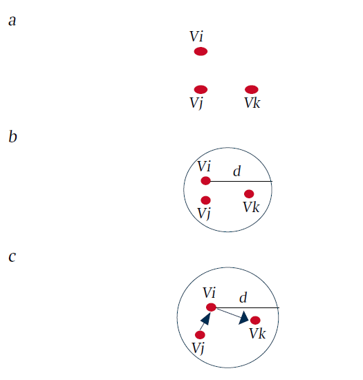
Once the set of nodes has been defined (Figure 1a), the next step is to define the special component or spatial units; in this particular case, spatial samples of radius are defined (Figure 1b). In other words, the process consists of dividing the territory into small areas of radius , taking into account each of the criminal events considered for this research as a centroid. An important aspect to be considered in constructing the networks is to accurately define the value assigned to , because they can hide or underestimate the incidence of criminal events in the patterns that energize the formation of space-time clusters. To solve this problem, we considered the principles of geographical juxtaposition of crime based on the CPTED (crime prevention through environmental design( theory by Cozens and Love (2015), which Forero et al. (2022) incorporate in their research and categorize into four spatial patterns. However, for this case, only three of these will be used: micro (incidence of crime in areas close to the occurrence of the event), proximal (incidence of crime in areas close to and continuous with the occurrence of crime), meso (incidence originating in regions close to the crime, up to distant areas). In accordance with the above, the set D ∈ d , considering the following distances to capture the micro, proximal and meso patterns are D = {10,100,1.000} (m). Despite this configuration of the model parameters, adjusted with the criminogenic theories, this algorithm can yield overdimensioned results due to the phenomenon of distances traveled. An example of this phenomenon is as follows: the pattern that is detected with a d =10 m, is embedded in a d=100 m , y and this, in turn, in d=1.000 m. On the other hand, the size of the network grows as the value of increases, which makes it very difficult to obtain a statistically significant pattern, reflecting conserved quantities (in the patterns), which in turn are robust. Davies and Marchione (2015) and Forero et al. (2022) defined that the best way to analyze these networks is from the perspective of assembling subgraphs or motifs. Motifs, according to Davies and Marchione (2015), Atluri et al. (2018) and Pasquaretta et al. (2021), are small subgraphs that repeat in a network, and their frequency, besides reflecting some connectivity patterns, are elements that have a low entropy in the data set that gave rise to the network. To solve these conditions, the Ergen algorithm (below) by Forero et al. (2022), was incorporated:
1. Motifs detection using the model by Paranjape et al. (2017), privileging some shapes applied to crime events established by Davies et al. (2015) and Forero et al. (2022), to find the micro, proximal and meso space-time patterns of Cozens et al. (2019) (see Figure 2).
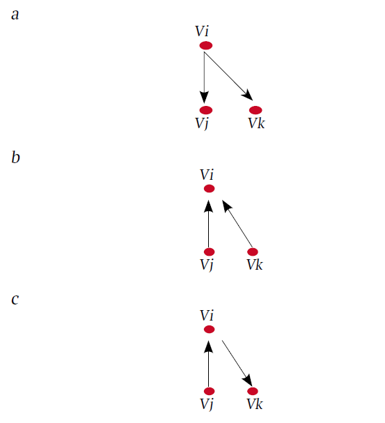
a. Expansion effect of crime with the passage of time (Out-2-Star). b. Compression effect of crime over time (In-2-Star). c. Movement or displacement of crime over time (direct relationship).
Figure 2 Motifs used to determine the configuration patterns of space-time clusters.
2. Toavoid overlapping networks as the distance d is modified, a permutation of the network adjacency matrix F is calculated, 10,000 networks are randomly selected and the motif detection algorithm defined in (1) is applied.
3. Once the motifs have been defined, the next step is to count the subgraphs, and according to their frequency and co-occurrence, their importance in the configuration of the space-time pattern is weighted.
4. Finally, a statistical significance test is performed on the results through the Z-score, to evaluate whether the form or motifs found are a subgraph that can explain the space-time dynamics of the criminal event.
5. An average is calculated from all the shapes found, and steps (2) to (4) are repeated n times, in this case according to Forero et al. (2022), n = 100.000.
Results
Theft dynamics in Pereira
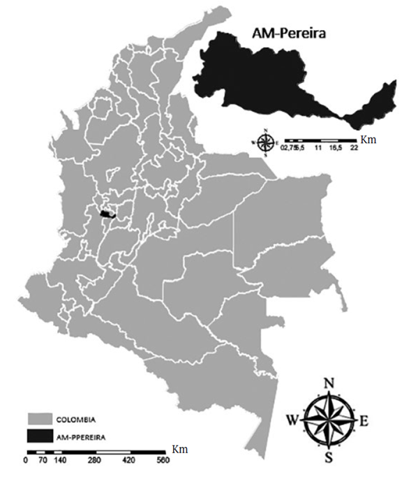
The metropolitan area of Pereira (MA-Pereira) is located in central-western Colombia (see Figure 3), strategically situated in the center of Colombia’s three economic and political axes: Bogotá, Medellín, and Cali. This metropolitan area is made up of three municipalities: Pereira (departmental capital), Dosquebradas, and La Virginia, all belonging to the department of Risaralda, and has a population of 741,534 inhabitants (República de Colombia, DANE, 2022).
The metropolitan area of Pereira is characterized as a place where the goods and services markets of the country’s three main cities converge (Zuluaga, 2013). It has historically constituted an axis of local development based on the trade of goods and services (Zuluaga, 2013). In addition to having consolidated a textile and coffee industry that brought wealth flows ( Jiménez García et al., 2021). This makes this metropolitan area highly dynamic economically and, therefore, attractive for capital investment.
The above conditions, which are attractive for economic dynamics, are also attractive for criminal contexts, and, like many of the country’s cities, Pereire too has a complex problem of organized and non-organized crime (Rentería-Ramos &Jiménez-García, 2020). MA-Pereira registers high homicide rates each year (generally above the national average), as well as other high-impact crimes such as theft (Jiménez-García, 2020).
Although MA-Pereira has a very active crime dynamic, few studies have attempted to analyze these dynamics (García, 2022; Jiménez-García & Martínez-Herrera, 2020). Most of these studies are descriptive, and although their productions (if viewed globally) contribute to an explanation of the criminal issue in the city, it is true that the reflections in the light of criminal theory are few (Rentería-Ramos & Jiménez-García, 2020). This leaves authorities and civil society with few alternatives to protect themselves or to make progress in finding solutions to such circumstances.
A total of 28,211 thefts were recorded in Pereira over the last ten years, an average of 2,821 thefts per year, with an average rate of 360 thefts per 100,000 inhabitants (see Figure 4).
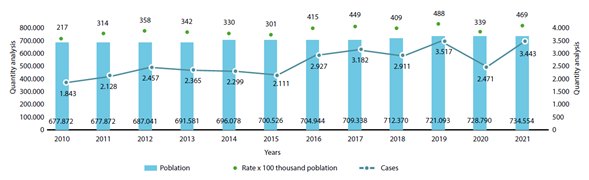
Source: Siedco, National Police. Crime statistics, Pereira Metropolitan Police, National Administrative Department of Statistics (DANE).
Figure 4 Temporal distribution of thefts in MA-Pereira, 2010-2020
Figure 4 illustrates a decrease in the number and rate of thefts during the pandemic (29.7%), which then recovered when citizens were allowed to move around the city again. However, it should be noted that this reduction was not significant, considering that mandatory preventive isolation (APO) in the city kept a large part of the population out of circulation.
In sum, despite the crime prevention and coercion strategies implemented by the authorities during the various city and metropolitan area administrations, the city of Pereira continues to have an active and constantly rising theft dynamic. The city’s economic and social context makes it attractive for this type of crime. Below, we focus on two specific spatial windows and discuss these theft conditions and socially configured environments.
Theft during and after APO
The pandemic affected social interaction in all its aspects (Fernández & Pedrero, 2021). It modified routines, especially those associated with mobility and the social construction of space. The Government of Colombia implemented a series of measures that restricted social contact: APO (República de Colombia, 2020a). As social contact was avoided, virtual mediation replaced these contacts and gave rise to new forms of social interaction, adapted to the global scenario that the planet was reproducing.
Virtuality made it possible to continue such contacts. Birthdays, religious celebrations, registry and notary acts, and even many jobs took place remotely, supported by the technological devices and platforms that allowed this connectivity. At the same time, the trade of illegal goods continued with the same logic. Drugs and other illegal goods were acquired remotely and delivered to the user’s home. While this was not new, the quantity of transactions was.
Although virtuality made it possible to adapt to the new reality and its restrictions, it was impossible for many sectors or activities to comply with or perform their tasks. Naturally, the medical emergency service (the most obvious and easy example), food production and sales, police surveillance services, and transportation services continued without mobility restrictions. Something similar happened in the illegal context, and the thefts are proof of this inability to adapt, above all, because theft essentially requires a perpetrator who conditions the relationship with the victimizer, and who takes possession of the goods of another.
The dynamics of theft varied with the APO measures. As in other contexts studied by researchers, theft in Pereira decreased (Abrams, 2020; Campedelli et al., 2021; Londoño et al., 2021). The fewer the people on the street the fewer people who are likely to be victims of theft (Topalli et al., 2002). Comparing pairs of months (pandemic month and non-pandemic month), it was found that the months with greater mobility restrictions (March, April, May, June, and July) saw the greatest decreases in the number of thefts. April and May recorded the largest decreases: April with 74.0 % reduction and May with 57.8 % (see Figure 5). Conversely, in months where mobility restrictions allowed more people on the street to circulate with social distancing, even more thefts were recorded than in non-pandemic times. For example, January 2021 recorded an increase of 26.0 % compared to the previous year (see Figure 5).
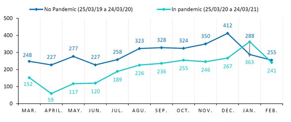
Source: Siedco, National Police. Crime statistics, Pereira Metropolitan Police.
Figure 5 Theft behavior before and during the pandemic
Another way to measure the impact of APO on this crime sector is the modification of the patterns of theft and offender dynamics on temporal and spatial scales.
Space-time patterns
The theft dynamics in the metropolitan area have historically been concentrated in four axes that coincide with the most dynamic centralities in terms of commerce and services (see Figure 6). These four axes are known as (1) Downtown Pereira (in the figure it is the most important hotspot); (2) Cuba, the most populous neighborhood in the Eje Cafetero (to the west of the city); and two axes in the municipality of Dosquebradas, known as (3) Santa Monica-La Pradera and (4) Guadalupe, which coincide with being the places with the highest land use value in the municipality adjacent to Pereira.
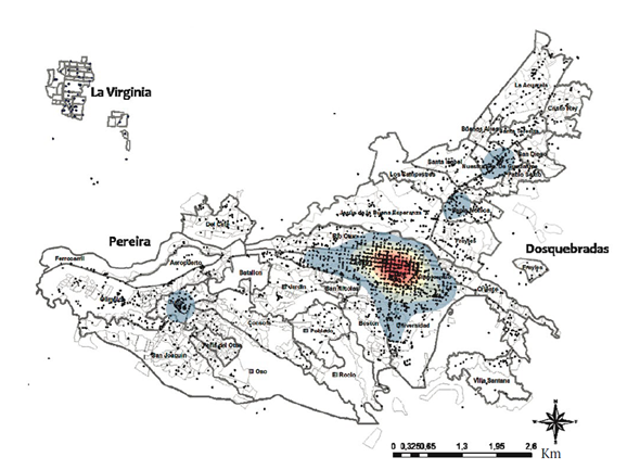
Source: Siedco, National Police. Crime statistics, Pereira Metropolitan Police.
Figure 6 Geolocation of theft from persons, from 03/01/20219 to 02/29/2020 Km
Figure 5 shows that there was a decrease in the num ber of thefts in the city due to mobility restrictions; however, the concentration of these thefts continued to be in the same places, and a corridor was even formed connecting the theft dynamics of Downtown Pereira with the sectors in Dosquebradas of Santa Monica-La Pradera and Guadalupe (see Figure 7). The figure also shows a change in the theft dynamics in the center of the city, with a decrease in the intensity of thefts in the university sector (as there were less students -potential victims- in this sector of the city), but at the same time, the theft radius increased in central sectors of the city, reaching even as far as the Jardín and Maraya sectors (see Figure 7).
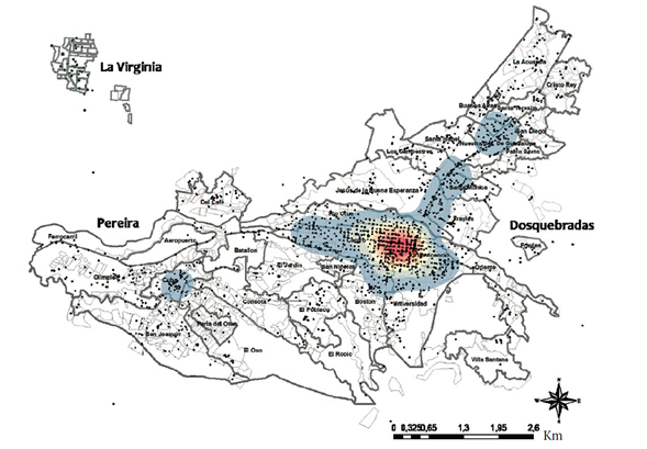
Source: Siedco, National Police. Crime statistics, Pereira Metropolitan Police.
Figure 7 Geolocation of the theft from persons, from 01/03/2020 to 29/02/2021
The maps in Figures 6 and 7 show the concentration of thefts in the entire MA-Pereira and how the pandemic modified this concentration, excluding areas of the city, such as the universities, hat were affected by the restriction, but moving to residential areas close to the center, as is the case for Jardín-Maraya and the residential area in Dosquebradas that was created as a corridor between the Pereira-Guadalupe Center (see Figure 7). Although these graphical results suggest that APO did have an impact, it is not possible to measure the socio-spatial-temporal influence of these measures. Figure 8 shows the entire network of events that were configured according to the methodology used, so that the impact of the restrictions so as to better explain the temporal and microspatial dynamics. In this sense, the theft events produced a highly assortative network, i.e., it is modular, which showed how the events are articulated to create the space-time clusters shaped by the theft dynamics (Rey et al., 2021). Although the network reveals that there are indeed clusters of events occurring in space-time (see Figure 8), also shown in the maps in Figures 6 and 7, this network does not reveal the patterns behind this configuration, which is why the spatial distances proposed in the methodology must be used.

Source: Siedco, National Police. Crime statistics, Pereira Metropolitan Police. Note. The two time windows studied are included.
Figure 8 Theft event network from a space-time perspective
The technique studied provides a view of theft behavior and the relationships of each criminal event from the space-time variables, from much smaller temporal and spatial slices than those recorded in Figures 6, 7 and 8. These slices are hourly and up to 100 meters. These smaller scales of analysis better explain the dynamics of theft in the city studied and are a powerful method of analysis for the criminogenic study of any space.
The results obtained are recorded in Figure 9. They show three different ways in which the thefts are grouped according to their spatial dynamics: (1) the expansive effect of theft (Out-2-Star; see Figure 2), in which from one point (node) they diffuse to two other points (nodes); (2) the compressive effect of theft (In2-Star; see Figure 2), in which from two points they retract to one point; and (3) the linear effect that indicates a displacement of theft (Path) (see Figure 2). The three effects coexist and are determined as dominant when the proportion of any one is greater than the others. In terms of a diagrammatic explanation, one of the effects is dominant and creates a pattern when the cloud of dots shown in Figure 9 is concentrated in the upper part and not in the lower part.
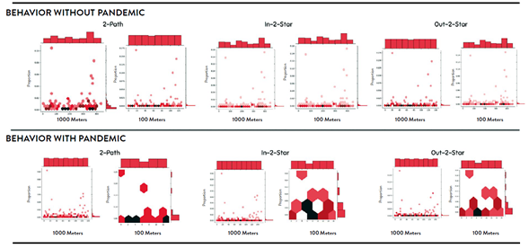
Figure 9 Space-time patterns of theft, Pereira (before and after mandatory preventive isolation (APO()
As for the expansive effect, this is not predominant at any of the time scales, nor at the proximal (1,000 meters) or micro (100 meters) scales. Some events (thefts) have a greater intensity and proportion (see Figure 9), especially in the pre-pandemic period, but their concentration is not homogeneous, which is why this is excluded as a conclusion.
This scenario is similar for the comprehensive effect and for the linear effect. There is no dominant connection in either, demostrating that there is no pattern at the different spatial scales; in other words, there is no one form that takes precedence over the other.
In this respect, the pattern at these spatial and temporal scales is the absence of a delinquent pattern, evident in the clusters shown in Figure 8.
Discussion of the results
The evidence collected allows us to affirm that the mobility restrictions, resulting from the COVID-19 pandemic, affected the theft dynamics in terms of the number of thefts. For two time windows (1 year), there was an average reduction in thefts of 38% (in the months of greatest restriction, this reduction in thefts was greater than 50%) (see Figure). This result is logical, because the restriction limited the potential number of victims and even limited the mobility of offenders.
In terms of spatial patterns, there is evidence of a displacement of thefts from the hotspots. This displacement ended up connecting two mixed zones (residential-commercial) to the west of the city and to the south of the municipality of Dosquebradas (see Figure). It also coincides with the “natural” flow that occurs between the centralities of the two conurbations. In other words, the dynamics of thefts are proof of the displacement of the individuals who commit the crime.
In this regard, it is important to note that the environmental munificence theory of crime (Aguilar, 2020; Beltrán & Salcedo-Albarán, 2007) helps to understand the creation of this new connecting axis of crime. According to this theory, the dynamics of crime are influenced by the criminal subjects’ reading of the environment, allowing them to adapt to and benefit from the conditions offered by the location. Notably, the two corridors offer alternatives to criminals, such as national urban roads, where there are few windows and the vehicular flow is dense; facilities with significant physical deterioration; persistent street dwellers; consumption of drugs such as heroin; and limited escape areas. These attributes increase the probability of assaults by criminals. Other attributes include the existence of spare parts stores and food and grocery stores, which guarantee a constant flow of pedestrians.
With respect to the space-time theft patterns, two elements should be mentioned: first, the MA-Pereira does not have a defined space-time pattern (see Figure), as does occur with the theft dynamics in Medellín (Bedoya, 2017. This can be explained by several reasons: unlike Medellín, the central areas of Pereira are not (and have never been) territorially dominated by any criminal organization (Bedoya, 2006, 2017; Jaramillo & Gil, 2016). This is why there is no “illegal command” of this activity by any actor. There has also been a recurrent phenomenon in the city, because professional gangs of robbers usually exercise their criminal action in Pereira on a seasonal basis and come from other cities, mainly Bogota (García, 2012). These gangs tend to operate seasonally given the city’s fertile environment for crime: urban decay in some sectors of the city, victims less concerned about creating a safe environment (culture of care), and the government’s poor understanding of the phenomenon.
With respect to the second factor, in MA-Pereira, the restrictions imposed by the APO did not affect the space-time patterns of theft in the city, which, as indicated in the results, there is no prevalence of one form over the other two (Forero et al., 2022). This fact confirms the inexistence of an actor that controls or orders the dynamics of theft.
The place is where social interactions take place and where the meanings of these interactions are defined. Once the meaning of a place is configured for a whole community (in this case the city), everything from the inhabitants’ identity to the use they give to the place -leisure, work or transi- is defined, thus, conferring sentimental value as well as economic value. As for theft, the places with the highest economic value are not necessarily those selected for this criminal activity (Kim et al., 2013).
The locations selected for theft are those where there are more passersby (potential victims) and where criminals confer a meaning to the place based on their criminal practice, i.e., using it to commit crimes. This valuation of the place by the criminal subject is based on the cost/benefit ratio, the history of success achieved in previous crimes, and environmental munificence (Beltrán & Salcedo-Albarán, 2007; Kim et al., 2013).
Conclusions
In the MA-Pereira, APO mobility restrictions reduced the theft rate, but did not modify the theft dynamics in the city; this is reflected in the space-time patterns, which were the same before and during the APO. These recurrent dynamics can be explained by the environmental munificence theory of crime, which indicates that crimes are committed due to the criminals’ reading of the environment surrounding the criminal act.
Of the three theft patterns, 2-Pah, In-2-Star and Out-2-Star, none predominate in Pereira; rather, they coexist. The pandemic did not alter this dynamic, i.e., in consolidating or dismissing the existence of one of the patterns. This is striking, given that the absence of space-time patterns, such as those analyzed, demonstrates elements such as the lack of territorial controls for theft by criminals or organized crime.
On the other hand, the consolidation of the three patterns provides evidence that criminal subjects dedicated to theft are capable of adapting to the conditions of a munificent environment for theft. This is demonstrated by the fact that they are capable of configuring the three space-time patterns, even in an atypical contingency such as the coronavirus pandemic.
The study of these spatial-temporal patterns that shed light on criminal dynamics on a proximal and micro scale, and on temporal scales in one-hour ranges, provides important tools when creating strategies to combat these criminal activities, with the added bonus of anticipating the geographic displacement that these activities would entail. This type of knowledge is innovative as an input for local and regional public policies against any crime.

