


Serviços Personalizados
Journal
Artigo
 Inglês (pdf)
 Artigo em XML
 Referências do artigo
 Enviar este artigo por email
Indicadores
-
 Citado por SciELO
 -
 Acessos
Links relacionados
-
 Citado por Google
 -
 Similares em
SciELO
Similares em
SciELO -
 Similares em Google
Compartilhar

 Permalink
Earth Sciences Research Journal
versão impressa ISSN 1794-6190
Earth Sci. Res. J. v.9 n.1 Bogotá jan./jun. 2005
JOSÉ M. JARAMILLO 1, PILAR ROJAS LINERO 2 AND JOHN I. GARVER 3
LATIN AMERICA ENTERPRISE FUND MANAGERS L.L.C
1 José M Jaramillo E-mail: jjaramillo@laef.co
2 E-mail: pililinero@hotmail.com.mx
3 Department of Geology, Union College, Schenectady, NY, USA. E-mail: garverj@union.edu
ABSTRACT
Volcanic ashes from local volcanic sources cover most of the Cordillera Oriental of the Colombian Andes. These tephra deposits are generally attributed to volcanoes to the west in the in the Cordillera Central. This study provides evidence that a thicker layer of tephra deposits, 20 to 40 m deep, that are most likely derived from newly recognized local volcanic sources in the Cordillera Oriental. The volcanic ashes that we attribute to the Paipa volcano and possibly others as yet unidentifi ed volcanoes in the Cordillera Oriental have new zircon fi ssion-track ages between 3.6 and 4.7 Ma, with a mean of 4.1 ± 0.5 Ma. We have also recognized younger pyroclastic deposits based on stratigraphic correlation. The high thermal gradient associated to these volcanoes could have had a signifi cant impact in the thermal maturation of the organic matter in Cretaceous and Paleogene sediments affecting the timing of oil generation and migration in the Cordillera and the Eastern Foothills, an area of active oil exploration and production. This discovery of young explosive volcanism highlights a serious potential geological hazard. The tephra deposits cover an extensive area of the "Altiplano Condi-boyacense", indicating that the volcanoes are highly explosive, and potentially dangerous for about 10 million people that inhabit the "Altiplano", its animals and crops.
Key words: Neogene Volcanism, Fission Track, Cordillera Oriental, Colombia.
RESUMEN
Las cenizas volcánicas de fuentes locales cubren la mayoría de la cordillera oriental de los Andes colombianos. Estos depósitos del tepha se atribuyen generalmente a los volcanes al oeste de la central de Cordillera. Este estudio proporciona evidencia de una capa más gruesa de los depósitos del tephra, 20 a 40 m de profundo, que se derivan muy probablemente de nuevas fuentes volcánicas locales reconocidas en la cordillera oriental, las cenizas volcánicas que atribuimos al volcán del paipa y otros los volcanes no identifi cados en la cordillera oriental tienen posiblemente hasta ahora nuevo fi sison del zircon - siga las edades entre 3.6 y 4.7 mA, con un fo malo 4.1 +-0.5 mA. También hemos reconocido depósitos pyroclasticos más jóvenes basados en correlación estratigráfi ca que el alto gradiente termal asociado a estos volcanes habría podido tener un impacto signifi cativo en la maduración termal de la materia orgánica en cretáceo y los sedimentos paleogene que afectan la sincronización de la generación y migración del aceite en la cordillera y las colinas del este, un área de la exploración petrolífera activa y producción este descubrimiento del volcanismo explosivo joven destacan un peligro geológico potencial serio. Los depósitos del tephra cubren un área extensa del altiplano Condi-boyacense, indicando que los volcanes son higly explosivo, y potencially dangerious para cerca de 10 millones de personas de que habiten el altiplano, él los animales y las cosechas.
Palabras Clave:Vulcanismo Neógeno, trazas de fisión, Cordillera Oriental.
INTRODUCTION
Volcanic activity from subduction of the Cocos plate is common along the plate margin that forms the Colombian Andes. Tephra deposits commonly cover the Andes in Colombia, and they are usually attributed to the chain of active volcanoes along the Western and Cordillera Central, however volcanic activity to the east in the Cordillera Oriental has generally been dismissed. Recently, however, several authors have proposed that the volcanic rocks that occur in the localities of Paipa and Iza in the Cordillera Oriental originated from the subduction of the Caribbean plate. (Taboada, et al., 2000). Here we present data to support the existence of a thick, 20-40m, layer of volcanic ashes that most likely originated from volcanoes in the Cordillera Oriental. These newly discovered tephra deposits are partially covered by a thinner layer of volcanic ash falls that in fact originated to the west from volcanoes of the Cordillera Central. One of the important aspects of these volcanic deposits is that their age is poorly known and as such, it is diffi cult to determine stratigraphic position and regional relationships.
The importance of this discovery lays in the fact that the explosive events that originated the tephra deposits could repeat causing a devastating impact on an area inhabited by more than 10 million people and one of the most productive agricultural regions in the country. Besides the recognition of Volcanic activity in the area during the last 5 to 10 million years must have had an impact on the thermal gradient of the area that could have a signifi cant impact in the timing of oil Generation and Migration in the Cordillera and Eastern Foothills.
STUDY AREA
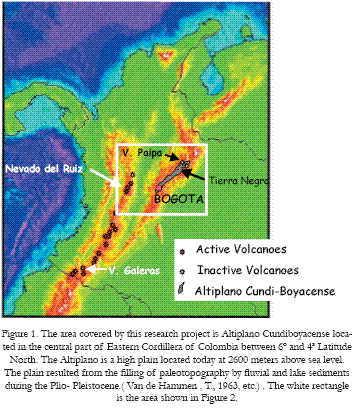
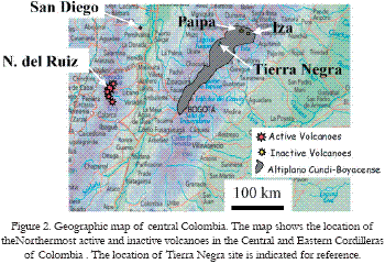
The study area is in the Altiplano Condi-boyacense, located in the central part of the Cordillera Oriental of Colombia between 6º and 4º North (Figure 1). Here the Altiplano is a high plain with mean elevations of about 2600 meters above sea level. The plain resulted from the fi lling of a paleo-topography by Plio-Pleistocene fl uvial and lake sediments (Julivert 1961, Van der Hammen, 1966, 1973, Helmens, 1990). The Tierra Negra site is located along the main road from Bogotá to Tunja, about one and a half kilometers north from Tierra Negra village in Boyacá. The elevation at the site is 2650 meters above sea level, with annual mean temperature of 13ºC and annual rainfall of 1000 mm.
According to existing geological maps (INGEOMINAS, 1964), the bedrock at the Tierra Negra (TN) locality consists of folded and faulted Upper Cretaceous marine sediments. Although not indicated in the maps, a thick layer of tephra deposits covers the Cretaceous sediments. At TN we have studied and sampled an excellent exposure on a road cut about 35 m high. The road cut exposes about 10 paleosol sequences developed one on top of each other on successive volcanic ash fall deposits.
METHODOLOGY
The TN stratigraphic section (Figure 2) was measured whith a metric tape along the slope of the road cut and later restored to true stratigraphic thickness. A gamma ray (GR) profi le was logged with a BGS-4 portable scintillometer taking readings in counts per seconds (CPS) every 20 cm along the road cut slope.
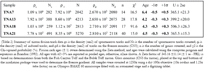
For fi ssion-track analysis, zircons were extracted from selected samples, mounted in PFA Tefl on, polished and etched in a NaOH: KOH eutectic. The mounts were covered with mica and irradiated at the Oregon State Nuclear Reactor with a nominal fl uence of 2 x 10¹⁵ n/cm2. Tracks were counted at 1250x (dry), and samples are calibrated to a zeta calibration (3xx.x ± xx P.R-L - need this number from Pilar - it is on the top of the data sheets) based on repeated measurements of the Fish Canyon Tuff and the Buluk Tuff (Garver, 2003) (see Table 1).
Major and trace element analyses were done by Actlabs, Ontario Canada, Detailed description of the analytical methods used by Actlabs can be consulted at www.Actlabs.com. The petrographic analyses were performed using grain mounts of pan concentrated tephra samples after washing away the very fi ne clay size matrix. X-ray diffraction analysis of the clay fraction was done at the "Instituto Geografi co Agustin Codazzi, IGAC, using the methodology developed by Thorez, 2002. Finally electron probe analysis was conducted at Harvard’s Center for Imaging and Mesoscale Structures, using a scanning electron microscope model FEI Quanta 200 equipped with EDAX.
RESULTS AND DISCUSSION
Stratigraphic Column
The standard fi eldwork on the road cut at TN and the gamma ray (GR) profi le resulted in the stratigraphic column shown in Figure 3. Based on our fi eld observations and the GR profi le, we were able to defi ne 10 distinct cycles on the outcrop. Each cycle consist of a soil profi le that is repeated with small variations about 10 times at the TN location. Each soil profi le has a 5 to 10 cm thick dark brown, organic rich "A" horizon followed by 1.5 to 2.0 meters reddish to yellowish "B" horizon. The "A" profi le is rich in rootlets molds and contains a number of dark colored phytoliths (Fig.3c-d).
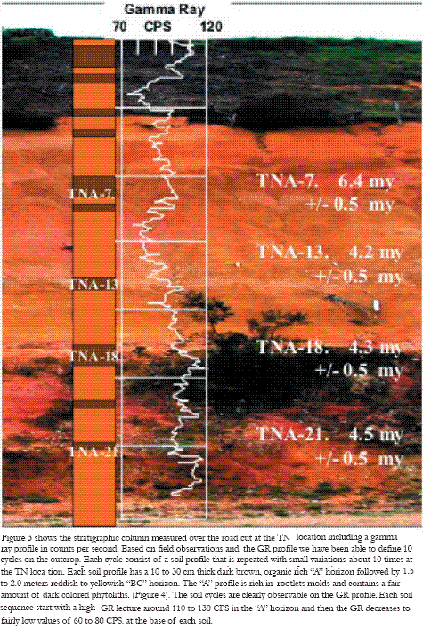
The soil cycles are clearly defi ned on the GR profi le, each soil sequence starts with a high GR value around 110 to 130 CPS in the "A" horizon and then the GR decrease to fairly low values of 60 to 80 CPS at the base of each soil profi le. A possible explanation for the behavior of the GR curve is that the high GR values are due to high uranium and thorium concentration in the reducing organic rich "A" layer and the lower values due to the solution and transport of U and Th in the more oxidizing "B" horizon. Or alternatively, that the A horizons are enriched on zircon grains relative to other minerals and volcanic glass due to the fact that zircons are very stable grains and could survive severe weather conditions.
A succession of at least 10 paleosols on a sloping mountain side as the TN location requires that each soil horizon be buried by new material in such way that the soil forming process is terminated and the new soil develops on top of the covering material, and this process repeats at least 10 times at TN. One or several of the following processes could explain such a succession of events. Each soil was: 1) Buried by rock and soil material transported by gravity; 2) Buried by material eroded from the surrounding mountains transported by the wind and deposited by gravity on the sloping hills; or 3) Developed on volcanic ashes and pyroclastic materials originating from nearby volcanoes, transported by wind and then deposited by gravity.
Helmens, K., 1990, describes similar reddish brown paleosols on top of Marichuela Fm., the Tibagota member of Tilata Fm. and the Chorrera Fm. and suggest that they probably mark a period of regional stability and hot climate at the end of the Pliocene or during one of the earlier interglacial periods.
Petrography
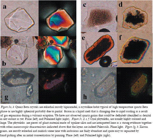
We studied 22 grain mounts of the sand size fraction grains separated from an equal number of soil samples taken from the TN outcrop at intervals of about 2 meters as shown in Fig. 2. The grain mounts studied under a petrographic microscope show that the sand fraction in these soils is comprised of 70% to 95% feldspar grains, 20% to less than 5% quartz grains, 5-1% of opal phytoliths and traces of zircon and opaque grains.
Feldspar grains are broken along cleavage planes, clean and twinned, usually corroded and contain glass inclusions (Fig. 3a-b). Quartz grains, are euhedral mostly bipiramidal (Fig. 3a-b) a crystalline habit typical of high-temperature beta quartz. Some quartz grains are highly spherical. This texture may be due to partial fusion in a liquid melt that changed due to rapid cooling as a result of gas expansion during a volcanic eruption. We have not observed quartz grains that could be defi nitely identifi ed as detrital in any mount asyet. Opal phytoliths are usually highly colored and large (Fig. 3cd) certainly due to fact that the samples were washed on a pan and most of the smaller size phytoliths most likely were washed away. Phytoliths are microscopic pieces of plant material made of opaline silica, Meunier et al, 2001, and are interpreted here as strong evidence together with other macroscopic characteristics indicated above that the layers are indeed paleosols, Sase et al, 2001.
Zircon grains are mostly euhedral and very light pink to colorless, with few inclusions and crystal defects (Fig. 3e-f). The soil samples have a fairly abundant content of zircon grains, which makes it easy to separate enough grains for FT dating by hand picking after an initial concentration by panning. Traces of Opaque grains, which also occur in all samples, are mainly spinel and ilmenite. At Tierra Negra we did not fi nd samples with mafi c grains such as pyroxenes, hornblende or biotite minerals that are common in tephras derived from andesitic volcanoes in the Cordillera Central (i.e. see Herd, 1982, Thouret, 1989, Toro, 1997).
Clay mineralogy was investigated by four X-Ray difractograms (Fig. 4a-d) that represent samples from the upper, middle and lower parts of the outcropping paleosol sequences (Fig. 2).
The diffraction peaks of all four samples are very wide and poorly developed. The two peaks that appear at 2?: 12.5º + 1.0º -2.0º (d = 6.6 +1.7 –0.5), and 25º+/- 1º (d = 3.54 +0,13 -0,14) correspond to poorly crystallized kaolinite group clays (Moore et al, 1997, p. 230), most likely halloysite, samples TN-A7 and TN-A13 have a some goethite (2??21.5º, d = 4.16).
In synthesis, the petrography and x-ray diffraction analysis of the soil layers indicates that the parental material of the paleosols is most likely volcanic glass and volcanic pyroclastic material that are highly weathered. We did fi nd traces of volcanic glass attached to quartz and feldspar grains in several samples. The fact that the soil samples consists mostly of poorly crystalline allophane and /or halloysite clays plus beta quartz with no mafi c minerals indicates that the volcanic ashes and pyroclastic material was highly silicic.
Geochemistry
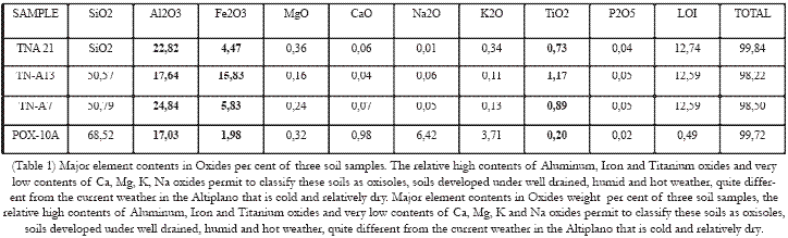
Major and trace elements analysis of three soil samples, TNA-7, TNA-13 and TNA-21 are shown in Table 2 and Table 3. The major element content of three soil samples and one rock sample, POX-10A from Olitas Volcano, a volcano located in the Eastern Cordillera, about 50 km. North of TN, are shown in Figure 5. The graphic shows that the soils samples TNA-7, TNA-13 and TNA-21 have higher content of Al2O3, Fe2O3 and TiO2 and much lower contents of CaO, MgO, K2O and Na2O than sample POX-10A.

The relative enrichment in Al, Fe, and Ti and the reduction of highly soluble cations: Ca, K and Na requires that the soils developed under well drained, humid and hot weather, quite different from the current weather in the Altiplano that is cold and relatively dry. Figure 6 show the chondrite normalized Rare Earth Element, REE, pattern of one paleosol sample: TN-A21 and two rock sample from the Olitas Volcano for comparison. The conclusion from this graph is that the paleosol REE pattern is quite similar to the REE pattern of volcanic rocks from the same region.
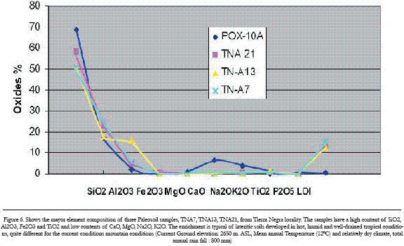
Figure 6. REE diagram shows the REE abundances, normalized to chondrite average, (of Anders and Grevesse 1989); of paleosol sample TN-A21 at the base of the paleosol sequence in Tierra Negra locality. Two other samples from Olitas Volcano in the Cordillera Oriental are shown. The REE pattern of all samples is similar and concave upward, note that there is no europium (Eu) anomaly.
Geochronology
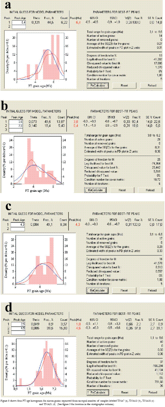
The base of the paleosols sequence described above is not exposed at Tierra Negra location and so far we have not seen it elsewhere. However based on the bedrock maps published by INGEOMINAS (ref), we can infer that the tephra layers at TN are on top of NAS (ref), we can infer that the tephra layers at TN are on top of Upper Cretaceous strata. In order defi ne the age of these paleosols and there parental rocks we used Fission Track dating of zircon, and palynology. For the FT dating we choose no to try to date the topmost Paleosoils as we tough they could be too young, this proved to be wrong as the youngest age was early Pliocene obtained from sample TNA-7 at 15 meters from the top. We tried to do pollen analysis from some of the paleosols, but we had no success because the soils are highly oxidized we only found some spores that were not useful for age correlation.
Figure 8 shows four FT age histograms for zircon grains separated from an equal number of samples labeled TNA7, TNA13, TNA 18 and TNA21 (see Figure 3 for location in the stratigraphic column, and Table 2 for data). Based on the histograms in Figure 8 and the fairly large standard deviation of the error for each date on can conclude that each dated soil sample appears to contain a mixture of volcanic material from different parts of the magma chamber and the wall rocks of the volcanic chimney. The apparent older age obtained for sample TNA7, which corresponds to the uppermost sample, dated to date in the TN paleosol sequence, could be possibly represent a phreato-magmatic explosive eruption that could consist mostly of wall rock material and therefore its age could be slightly older than the age obtained from freshly erupted magma. We are preparing a detailed sampling of this outcrop to verify this hypothesis. Alternatively, this particular tephra may have had a signifi cant amount of reworked zircon incorporated during transport.
CONCLUSIONS
These paleosol sequences from Tierra Negra, Boyacá, Colombia, are not an isolated patch but a layer that covers a vast region of are not an isolated patch but a layer that covers a vast region of the Altiplano and surrounding mountains. The tephra deposits are diffi cult to map accurately because of the lack of outcrops outside the main roads. However they are very distinctive in the geomorphological aspects manifested in the rolling hills with very smooth relief along the road from Bogotá to Paipa.
We can estimate the depositional age of these tuffs based on the zircon fi ssion track age determinations for four samples. These samples (TNA-7, 13,18 and 21) have a mean age of 4.1 Ma +0.5 –0.6 (based on 91 grains). Individual age estimates on single samples are within error of one another. This result indicates that a large region in the Tierra Negra saw a series of explosive volcanic events between about 3.6 and 4.7 Ma. However one must note that this is a minimum age range since the dated material does not include the base or the top of the paleosol sequence.
These results confi rm the conclusion, derived from petrographic observations that the Tierra Negra deposits consist exclusively of volcanic material without signifi cant detrital contamination for surrounding rocks. Most of the underlying rock is Upper Cretaceous (c. 65 Ma), and there is no evidence that contamination from these strata affected the detrital zircon FT ages.
Helmens, K., 1990, describes similar reddish brown paleosols on top of Marichuela Fm., the Tibagota member of Tilata Fm. and the Chorrera Fm. and suggest that they probably mark a period of regional stability and hot climate at the end of the Pliocene or during one of the earlier interglacial periods. Contrary to this view and based on the results of this study we propose that the reddish brown paleosols that are very widespread in the "Altiplano" of the Eastern Cordillera of Colombia developed in Early Pliocene before the Uplift of the Cordillera.
The importance of this discovery lays in the fact that the explosive events that originated the tephra deposits could repeat causing a devastating impact on an area inhabited by more than a 10 million people and one of the most productive agricultural regions in the Country.
The existence of volcanic activity in the area during the last 5 to 10 million years should have an impact on the thermal gradient of the area, which could have a signifi cant infl uence in the timing of oil Generation and Migration in the Cordillera and Eastern Foothills. Another aspect that should be investigated is the impact on the vegetation caused by the deposition of relatively thick, tephra layers. Several authors: Van der Hammen , T., 1966, Van der Hammen, T., et al., 1973, Hooghiemstra, H., 1984, Hooghiemstra, H. et al. 1989., Hooghiemstra, H. et al. 1993., Hooghiemstra, H. et al. 1994a., Hooghiemstra, H. et al. 1994b., Van der Hammen T. et al., 1997., Mommersteeg H.J.P.M., 1998., among others, used variations on the vegetation cover, as inferred from variation in the pollen content of sediments, as a proxy for climatic changes, during the last 5 my, in the Bogotá "Altiplano" . However these authors have not considered that at least some of the vegetation changes could have been induced by the deposition of volcanic tephras.
ACKNOWLEDGEMENTS
Steve Reese coordinated irradiation of zircon fi ssion-track samples at the Oregon State Nuclear reactor and the U.S. D.O.E. Reactor Use Sharing program supported the irradiation.
REFERENCES
Anders E. and Grevesse N. (1989) "Abundances of the elements: Meteoritic and solar" Geochim. Cosmochim. Acta 53, 197-214. [ Links ] Garver, J.I., 2003, Etching age standards for fi ssion track analysis; Radiation Measurements, v. 37, n. 1, p. 47-54. [ Links ]
Helmens, K., 1990. Neogene-Quaternary Geology of the High Plain of Bogotá, Eastern Cordillera, Colombia. Dissertations Botanicae, 163. pp 202 [ Links ]
Herd, D.M., 1982 Glacial and Volcanic Geology of the Ruiz-Tolima Volcanic complex, Central Cordillera, Colombia. Publ. Geol. Esp. INGEOMINAS (Bogotá), Vol. 8 , [ Links ]
Hooghiemstra, H., 1984 Vegetation and climatic history of the High Plain of Bogotá: A continuous record of the last 3.5 million years. The Quaternary of Colombia, Van Der Hammen T. Editor. J. Cramer Verlag, Vaduz : 368 p. [ Links ]
Hooghiemstra, H. et al. 1989., [ Links ]
Hooghiemstra, H. and Van der Hammen T., 1993 Late quaternary Vegetation history and Paleoecology of Laguna Pedro Palo (Subandean forest belt, Eastern Cordillera, Colombia.). Review of Paleobotany and Palynology vol. 77. 235-262. [ Links ]
Hooghiemstra, H. and Ran E.T.H., 1994a Late and Middle Pleistocene climatic change and forest development in Colombia: pollen record FUNZA II (2-158 m core interval) Paleogeography Paleoclimatology Paleoecology vol.109 p211-246 [ Links ]
Hooghiemstra, H. and Ran E.T.H., 1994b. Late Pliocene-Pleistocene high resolution pollen sequence of Colombia: An overview of climatic change. Quaternary International 21, pp 63-80 [ Links ]
Julivert M., 1961, Observaciones sobre el Cuaternario de la sabana de Bogotá, Boletín de Geología, Universidad Industrial de Santander, Bucaramanga. Vol. 7, 5-36 [ Links ]
Meunier J.D.,and Colin F., 2001: Preface to "Phytoliths: Applications in Earth sciences and Human History". A.A. Balkema Publishers /Lisse/Abingdon /Exton(Pa)/Tokio. pp 378. [ Links ]
Mommersteeg H.J.P.M., 1998, Vegetation development and cyclic and abrupt climatic changes during the Late Quaternary. Palynological evidence from the Eastern Cordillera of Colombia. The Quaternary of Colombia , vol. 25 , 191 p. [ Links ]
Moore D.M., and Reynolds R.C., 1997: X-Ray diffraction and the Identifi cation and Analysis of Clay Minerals, Second Edition, Oxford University Press, NY. pp 378 [ Links ]
Taboada, A., L. Rivera, A. Fuenzalida, A. Cisternas, H. Philip, H. Bijwaard, J. Olaya and C. Rivera (2000). Geodynamics of the Northern Andes : Intra-continental subduction and the Bucaramanga seismicity nest (Colombia). Tectonics, 19(5), 787-813. [ Links ]
Thouret J.C., 1989, Suelos de la Cordillera Central, Transecto Parque los Nevados. In: Studies on Tropical Andean Ecosystems, Vol. 1, 262-276 (T. Van der Hammen et al. editors). [ Links ]
J. Cramer, Vaduz. Toro, G.,1989. Caracterización del Volcanismo de San Diego y estudio de los Depósitos de San Diego (Caldas) y de Nariño (Antioquia), Colombia. Memorias de V Congreso Colombiano de Geología, Bucaramanga, Marzo14-17. Socieda Colombiana de Geología, Ed. , 419-440. [ Links ]
Toro G., y Hermelin M. 1992. Tefraestratigrafi a Colombiana. Revista U. EAFIT, No. 86, 81-84. [ Links ]
Sase T., and Hosono M., 2001: "Phytolith record in Soils interstratifi ed with late quaternary tephras overlaying the eastern region of Towada Volcano, Japan" in "Phytoliths: Applications in Earth sciences and Human History". A.A. Balkema Publishers /Lisse/Abingdon/ Exton(Pa)/Tokio. pp 378. Meunier J.D., and Colin F. editors. [ Links ]
Van der Hammen , T., 1966, The Pliocene and Quaternary of the Sabana de Bogotá. (The Tilata and Sabana Formations), Geologie en Mijnbouw, vol.45, 102-109 [ Links ]
Van der Hammen, T., et al., 1973, Palynological record of the Upheaval of the Northern Andes: a study of the Pliocene and lower Quaternary of the Colombian Eastern Cordillera and the early evolution of its High-Andean biota. Rev. of Paleobotanica and Palynology. Vol.16, 1-122. [ Links ]
Van der Hammen T., and Hooghiemstra H., 1997 Chronostratigraphy and correlation of the Pliocene and Quaternary of Colombia, Quaternary International, 40, 81-91. [ Links ]

