


Services on Demand
Journal
Article
 English (pdf)
 Article in xml format
 Article references
 Send this article by e-mail
Indicators
-
 Cited by SciELO
 -
 Access statistics
Related links
-
 Cited by Google
 -
 Similars in
SciELO
Similars in
SciELO -
 Similars in Google
Share

 Permalink
Earth Sciences Research Journal
Print version ISSN 1794-6190
Earth Sci. Res. J. vol.9 no.1 Bogotá Jan./June 2005
SPATIAL MAPPING OF THE B-VALUE AT GALERAS VOLCANO, COLOMBIA, USING EARTHQUAKES RECORDED FROM 1995 TO 2002
JOHN J. SÁNCHEZ1, D. M. GÓMEZ2, R. A. TORRES2, M. L. CALVACHE3, A. ORTEGA2, A. P. PONCE2, A. P. ACEVEDO4, F. GIL-CRUZ4, J. M. LONDOÑO4, S. P. RODRIGUEZ4, J. DE J. PATIÑO4 AND O. P. BOHÓRQUEZ4
1Geophysical Institute, University of Alaska, Fairbanks, e-mail:jjalaska@giseis.alaska.edu Geophysical Fairbanks
2INGEOMINAS-Observatorio Vulcanológico y Sismológico de Pasto 2
3INGEOMINAS 3
4INGEOMINAS-Observatorio Vulcanológico y Sismológico de Manizales
ABSTRACT
The catalog of volcano-tectonic earthquakes at Galeras volcano, Colombia, was analyzed to determine the magnitude of completeness of the seismograph network and to explore the subsurface structure by mapping the b-value of the frequency-magnitude distribution. By using 8,435 well-located earthquakes between 1989-2002 we found the catalog to be complete above MD=0.26. The average b-value of 0.71 was found to be the result of an unintentionally stretched magnitude scale. The two- and three-dimensional mapping of b-value illuminates a vertically elongated structure beneath the active crater of Galeras down to a depth of 6 km, which may be associated with a conduit, or alternatively, with a shallow region of temporary magma storage. A structure with this geometry and location has not been found before in previous studies of b-value on volcanoes around the world.
Key words: seismology, Galeras volcano, b-value, earthquarques.
RESUMEN
El catálogo de Sismosº Vulcanotectonicos en el Volcan Galeras, Colombia, fué analizado para determinar la magnitud de completitud, de la red sismografi ca y explorar las estructuras del sub-suelo mapeando los valores b, asociados a la distribución frecuencia - magnitud. Utilizando 8.435 eventos bien localizados, para el periodo 1989 -2002 se encontró que el catalogo estaba completo por encima de Md=0.26. El valor promedio b=0.71 fué encontrado mediante un no- intencionado estiramineto de escala de magnitudes. El mapeo bidimensional y tridimensional del parametro b discrimina una estructura verticalmente elongada debajo del crater activo del Galeras a una profundidad de 6 Km, que estaria asociada con un conducto ó con un almacenamiento temporal de de magma en una zona somera. Una estructura con esa simetría y localización no ha sido reportada antes en estudios previos del valor b en Volcanes alrededor del mundo.
Palabras Claves: Sismología, volcan Galeras, Valor b, terremotos.
INTRODUCTION
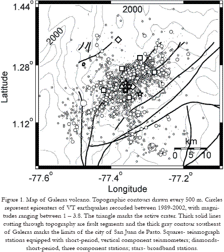
Galeras volcano is located in southwestern Colombia, 9 km from the city of San Juan de Pasto (pop. ~ 350,000 ) and it is one of the most active volcanoes in the region, with major eruptions over the last 4,500 yr (Calvache, 1990). In 1988 Galeras showed signs of unrest and erupted explosively in 1989; an andesitic lava dome was emplaced during September-November 1991, and explosive activity took place again during 1992-1993. The last explosive eruption occurred on June 7, 2002 (Global Volcanism Network, 2003).
Between 1989 and 2002 The Observatorio Vulcanológico y Sismológico de Pasto (OVSP) has compiled an important catalog of earthquakes locations and this offers the possibility of determining the magnitude of complete detection and spatially mapping the b-value to explore the internal structure of the volcano down to a depth of 10 km. Between 1991 and 1992 the seismicity at Galeras was characterized by the occurrence of long-period events (LP) but also volcano-tectonic earthquakes (VT) were recorded (Gil-Cruz and Chouet, 1997). Both types of events, however, form the background seismicity at the volcano from 1993 until present. In this work we focus on the VT earthquakes. These earthquakes usually show sharp and distinct arrivals of P and S waves to the various seismograph stations, and broadband spectra, commonly above 5 Hz (Lahr et al, 1994). The sharp arrivals of P and S waves allow reliable location of the earthquakes. From 1993, the locations of VT earthquakes around Galeras illuminate several particularly active regions north of the active crater (Figure 1).
The distribution of earthquakes sizes in a region can be described by a law identifi ed by Ishimoto and Iida in 1939, and later by Gutenberg and Richter in 1944:
where N is the cumulative number of earthquakes with magnitude larger than or equal to M, and a, b are constants that describe the activity of a seismogenic region and the relative distribution of earthquakes sizes, respectively. When plotting the cumulative number of earthquakes versus their magnitudes (frequency-magnitude distribution, FMD), b represents the slope of the best-fi tting line for a certain magnitude range and is inversely proportional to the average size of faults that rupture during earthquakes (Aki, 1965). Values of b are close to 1.0 in the Earth’s crust (Frolich and Davis, 1993) but in volcanic regions b is commonly higher than 1.0 (Wiemer and McNutt, 1997; Wyss et al., 2001, Sánchez et al., 2004). This anomalously high b-value at volcanoes has been attributed to excessive material heterogeneity (Mogi, 1962), decreased applied stress (Scholz, 1968), decreased effective stress (high pore pressure) (Wyss, 1973), or alternatively, elevated thermal gradients (Warren and Latham, 1970). In this work we determine the magnitude of completeness (Mc) of the seismograph network and then we select a subset of data that is optimal for spatial mapping of b.
DATA
From 1989 the seismic activity at Galeras has been monitored with a 3 to 9-stations seismograph network. (Figure 1). The network is equipped with fi ve L-4 Mark Products vertical-component seismometers (fl at response between 1 - 10 Hz) with one Hertz natural frequency, two L-22 Mark Products three-component seismometers (fl at 2 to 20 Hz) with 2 Hertz natural frequency; and four Broadband, three-component seismometers (two Guralp CMG- 40T and two Strekeissen STS-2, fl at 0.02 to 50 Hz) with 0.01 Hz natural frequency.
Earthquakes are located by reading the arrival times of P and Swaves to several seismograph stations and using the iterative computer program HYPO71 (Lee and Lahr, 1975). A one-dimensional model consisting of fi ve layers over a half-space, with velocities increasing with depth, and constant Vp/Vs = 1.78 is used as approximation to the distribution of velocities in the Galeras area. Table 3.1 lists the parameters of the velocity model.
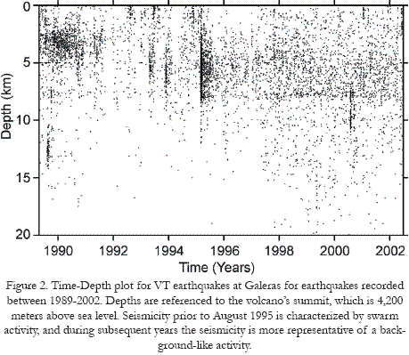
The VT earthquakes occur close to the active crater with an apparent tendency to align with the active faults mapped in the region of Galeras, particularly in direction SW-NE, although there are also earthquakes that align in direction SE-NW (Figure 1). The depths of earthquakes vary, but we observe a dominance of hypocenters between the summit and 10 km depth (Figure 2). We also observe that between 1989 and mid-1995 the seismicity rates vary quite frequently because of intense swarm activity. After August 1995 the distribution and rates of earthquakes are more representative of background-like seismicity.
We use the catalog of earthquakes and map the b-value to recognize the regions where the production of small earthquakes is statistically higher or lower than average. This is of interest because several workers at volcanoes elsewhere have suggested a relationship between high b-values, and possible regions of high material heterogeneity, high pore pressure, decreased applied stresses and high thermal gradients; which are conditions that intuitively are expected near magma conduits or reservoirs.
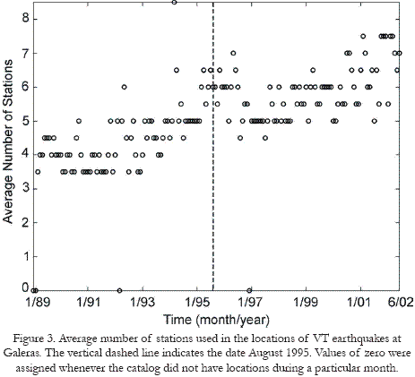
On average, the number of stations used routinely for locations of VT earthquakes shows a clear tendency to increase with time (Figure 3), which also prompted us to use the more recent data since 1995. The original catalog compiled by OVSP 8,435 earthquakes with magnitudes in the range -1.2 to 4.5. The original magnitudes are duration magnitudes (MD) estimated from the duration of shaking, starting from the onset of the P-waves until the coda waves are roughly equal in amplitude to the background noise. We discarded earthquakes without magnitude computation or with no estimates of the location errors.
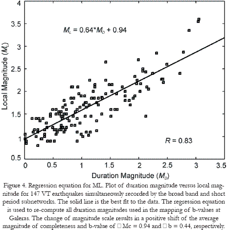
We computed preliminary estimates of the Mc and b-values using the original MD of earthquakes and found that the average Mc and b-value were 0.26 and 0.71, respectively. This suggests that the magnitude scale is unintentionally stretched and implies that in terms of the usual b-values (b~1) our anomalous volumes have low values. Thus we could argue that it is still possible to map volumes of high b, relative to "normal" (what we defi ne as the average b in our catalog). Although it is diffi cult to devise a magnitude scale that is identical to that originally defi ned, we used amplitude data for 147 earthquakes recorded at the four broadband stations between April 2002 and September 2003, and duration data for the same set of earthquakes recorded by the short-period network to derive a regression equation to convert all magnitudes in the catalog from MD to ML (Figure 4). This implies that our new mag- nitudes will be scaled up by some amount and produce Mc and b-values that look comfortably similar to those in other areas. We feel, however, that we still cannot directly compare b-values in one local catalog to those in another and recommend that the results of this work be cautiously used and with comparison purposes in the Galeras area only, without attempting to derive conclusions on the absolute value of b.
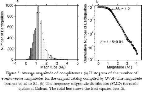
The histogram of the number of events versus magnitudes shows a simple distribution (Figure 5a), with some peaks, but in general uniform. The maximum in number of earthquakes occurs in the magnitude range 1 to 1.5, which is a fi rst indication of the value of Mc of the catalog. Indeed, an automatic estimate, based on least squares, shows Mc = 1.2. The slope of the line that best fi ts the FMD for earthquakes with ML > 1.2, is b = 1.15 (Figure 5b).
The formal errors in locations of earthquakes used here, as estimated by the computer program HYPO71 (Lee and Lahr, 1975), are on average 1 and 2 km in the horizontal and vertical directions, respectively. The errors in depth decrease to 1 km after August 1995, which may refl ect the improvement of the monitoring network.
Because the Mc varies with time as a result of factors such as changes in seismograph network confi guration and detection systems, instrumental failures, increased awareness and level of detail during times of volcanic unrest, and also temporal changes introduced by different human analysts during routine locations; we study the magnitude of completeness of the Galeras catalog by using a moving windows technique. For the catalog ordered sequentially in time, the detection threshold is calculated for the fi rst 300 events by using the FMD, then the window is moved forward in time by 5 events and the computation is repeated, proceeding systematically until the end of the catalog. In this fashion we obtain a smoothed graph of Mc versus time (Figure 6).
We decided to divide the catalog of VT earthquakes at Galeras into two periods: pre- and post-August 1995. Because the activity prior to August 1995 was characterized by swarm activity we use only 1918 earthquakes with ML > 1.2 recorded between September 1995 - June 2002 that represent better the background seismicity. This decision is based on the temporal characteristics of the VT activity (Figure 2), the gradual improvement of the seismograph network that resulted in a higher number of stations being used for the locations (Figure 3); and on average, a lower Mc (Figure 6), which allows expanding the range in magnitudes for analysis and maximizes the usable number of earthquakes. We note that the error estimates of our earthquake data are within the uncertainties that are usually expected for locations obtained from arrival times to stations in a sparse network. Our mapping of b-values is based on grids with nodes separated accordingly.
METHOD
To compute the b-value, we apply the method of Maximum Likelihood (Aki, 1965),

where Mavg is the mean magnitude and Mo = Mc – 0.05 (0.05 is a half of the magnitude bin unit of 0.1). Because Mavg – Mo and b are inversely proportional, whenever we measure b, we are also measuring Mavg.
To map b we use the method of Wiemer and Benoit (1996), Wyss et al., (1997), and Wiemer et al., (1998). Briefl y, the b-values are calculated in two and three dimensions at grid nodes that are 2 km apart (horizontally and vertically), using a fi xed number of earthquakes (n = 100) without limiting the size of the sampling volumes. During this mapping we observed that the radius of sampling varied between 1 and 6 km. In two dimensions, the nearest 100 earthquakes are selected according to their distances projected onto a vertical (cross-section) or horizontal (map-view) plane; therefore the sampling volumes are cylinder-shaped and varying in height. In the case of three-dimensional mapping the sampling volumes have the shape of spheres. To verify that the results are independent of the method used, we computed b-values using two methods: Maximum Likelihood (ML) and Weighted Least Squares (WLS). Because the spatial patterns in b-values were invariant, we only show the maps obtained using the ML method. For a detailed discussion on the different methods used to estimate b and a comparison of results, the reader is referred to Centamore et al., 1999.
RESULTS
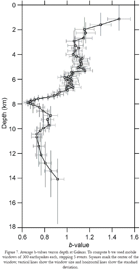
The average b-value (ML > 1.2) between September 1995 and June 2002 starts at b = 1.46 at shallow depths, decreases gradually to b = 1.0 at 7 km depth, then decreases rapidly to b = 0.7 at a depth of 8 km and below this depth the b-values oscillate between b = 0.7 and b = 0.9. Below 14 km depth the amount of earthquakes is not enough to estimate reliably the b-values (Figure 7). In map view and cross-section trough the active crater (Figure 8a, b) we see that regions of low b-value are common and that the region located adjacent and beneath the active crater shows the highest b-values, this region extends from the summit of the volcano down to a depth of 5 km.
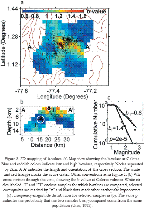
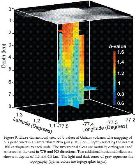
These spatial patterns persisted when we mapped b under the assumption that Mc varies spatially at each sampling node; assuming that Mc is constant through the region; or changing the sampling method by using constant radius of 2 km and letting the number of earthquakes fl oat. The differences in b-values among spatially different volumes are signifi cant because the estimated probabilities that samples taken from contrasting regions come from the same population (Utsu, 1992) are low (Figure 8c). The three-dimensional mapping of b for Galeras volcano (Figure 9) confi rms that the high b-values region is located beneath the active crater and vertically elongated down to 5 km depth.

DISCUSSION
The b-values calculated in this study are similar to those found by Eraso and Guerra (2002) in their study of the seismogenic regions around Galeras. They found that shallow sources that are close to the crater show b-values that are higher than those for deeper sources away from the vent. Because the absolute value of b depends on the magnitude scale used (Zúñiga and Wyss, 2001) we suggest that our estimates be taken with caution and used only for comparison purposes within the Galeras region. The contrast in b-value among different volumes that we document here is robust because the statistical tests indicate low probabilities that samples taken from contrasting regions are the same; and the spatial pattern of anomalies in b-values persists, independent of the methods used in sampling of earthquakes and estimating b.
Wiemer (1996) put forward the idea that restricted volumes of anomalously high b-values exist at volcanoes. This hypothesis has been tested at a number of volcanic regions: Mt. St. Helens, Washington, and Spurr, Alaska (Wiemer and McNutt, 1997); Off-Ito, Japan (Wyss et al., 1997); Long Valley, California (Wiemer et al., 1998); Soufriere Hills, Montserrat (Power et al., 1998); Katmai, Alaska (Jolly and McNutt, 1999), Etna, Italy (Murru et al., 1999); Kilauea, Hawaii (Wyss et al., 2001); and Mt. Pinatubo, Philippines (Sánchez et al., 2004). Thus, high b-value anomalies seem pervasive and independent of the type of volcano, although the pattern of the anomalies does vary.
There are many possible causes for higher-than-normal b-values at volcanoes. At Galeras, the high material heterogeneity was highlighted as likely by Eraso and Guerra (2002) and related to the high b-values calculated for sources beneath and west of the vent. A possibility for the material heterogeneity close to the crater could be the fracturing of a semi-brittle magma body. When rapidly deformed, these bodies can fracture just as seen on the surface of lava domes, and the earthquakes thus generated would be relatively small (C. Newhall, Pers. Comm., 2003, Sánchez et al., 2004). Because Galeras has shown frequent eruptive activity, including emplacement of a lava dome (Calvache and Williams, 1997), we speculate that the high b-values found beneath the active crater may correspond to the regions adjacent to a conduit, the remnants of a semi-crystallized intrusion, or a shallow and temporary magma reservoir.
The total volume of the dome and its conduit system emplaced at Galeras between 1990-1992 was estimated as 8.4 x 10⁶ m3 by Calvache and Williams (1997), the b-value anomaly that we report here is larger, ~ 32 x 106 m3, which makes sense, if it surrounds a shallow semi-crystallized magma body.
Temporal changes in b-values at Galeras have been studied with some detail (Torres and Gómez, Pers. Comm., 2004). The b-values on the most active seismogenic sources at Galeras are also in the range 1.0 – 1.4 and it is speculated that the variations in b are related to changes in the volcano’s eruptive activity. In this work, however, we limit our analysis to spatial changes and suggest, as future work, the refi ning of the study of temporal variations by using a differential mapping technique (Wiemer et al., 1998).
Galeras is not the exception among other volcanoes where b has been mapped, and several other possibilities for the generation of higher-than-normal b-values remain an open question. The location and apparent confi guration of the anomaly found here, however, illuminates a new feature that has not been mapped by this method before (Figure 9). Perhaps the application of earthquakesrelocation techniques and mapping using other approach (P-and S-wave velocity tomography) can put our results to the test.
CONCLUSIONS
The relative distribution of VT earthquakes magnitudes at Galeras volcano, Colombia has been mapped to a depth of 8 km below the summit. We found relatively higher b-values in an elongated region below the vent and down to a depth of 5 km. This indicates the occurrence of earthquakes that are smaller than average. The higher-than-normal b-values can result from high pore pressure, repeated intrusions and eruptions, or alternatively, from high material heterogeneity (as produced by many fractures). There exists the possibility that we are illuminating the region adjacent to the conduit, a shallow magma reservoir, or the remnants of a semicrystallized intrusion.
ACKNOWLEDGEMENTS
The authors wish to thank INGEOMINAS and all the staff at OVSP, Colombia, for their hard work in maintaining the monitoring network at Galeras, also for the help and data provided during the visit of one of the authors (J.J.S.) during which this work was initiated. IAVCEI provided some fi nancial support for the project. Natalie Ortiz helped in the organization and compilation of data. Max Wyss provided advise and helpful discussion.
REFERENCES
Aki, K. (1965): "Maximum likelihood estimate of b in the formula log N=a-bM and its confi dence limits". Bulletin of the Earthquake Research Institute, University of Tokyo, 43, 237-239. [ Links ]
Calvache, M. L. and S. N. Williams. (1997): "Emplacement and evolution of the andesitic dome of Galeras volcano, 1990-1992". Journal of Volcanology and Geothermal Research, 77, 57-69. [ Links ]
Calvache, M. L. (1990): "Geology and Volcanology of the recent evolution of Galeras volcano, Colombia". (M.S. thesis). Baton Rouge, Lousiana State University, 171 p. [ Links ]
Centamore, C., G. Patane, and T. Tuve (1999): "Maximum entropy estimation of b values at Mt. Etna: comparison with conventional least squares and maximum likelihood results and correlation with volcanic activity". Annali di Geofi sica, 42, 515-528. [ Links ]
Eraso, J. F., y Guerra, A. C. (2002): "Análisis de fuentes sismogénicas registradas por la red sismológica de vigilancia del volcán Galeras, como una contribución al estudio de amenaza sísmica de la región de infl uencia del volcán", Tésis de Grado, Universidad de Nariño, Facultad de Ingeniería Civil, San Juan de Pasto. [ Links ]
Frolich, C. and S. Davis (1993): "Teleseismic b-values: Or much ado about 1.0". Journal m of Geophysical Research, 98, 631-634. [ Links ]
Gil Cruz, F. and B. Chouet (1997): "Long-period events, the most characteristic seismicity accompanying the emplacement and extrusion of a lava dome in Galeras volcano, Colombia, in 1991". Journal of Volcanology and Geothermal Research, 77, 121-158. [ Links ]
Global Volcanism Network (2003): "Bulletin of the Global Volcanism Network 28:02". http://www.volcano.si.edu/world/region15/ colombia/galeras [ Links ]
Gutenberg, B. and C. F. Richter (1944): "Frequency of Earthquakes in California". Bulletin of the Seismological Society of America, 34, 185-188. [ Links ]
Ishimoto, M. and K. Iida (1939): " Observations of earthquakes registered with the microseismograph constructed recently". Bulletin of the Earthquake Research Institute, University of Tokyo, 17, 443-478. [ Links ]
Jolly, A. D., and S. R. McNutt. (1999): "Seismicity at the volcanoes of Katmai National park, Alaska; July 1995-December 1997". Journal of Volcanology and Geothermal Research, 93, 173-190. [ Links ]
Lahr, J.C., B. A. Chouet., C. D. Stephens., J. A. Power and R. A. Page (1994): "Earthquake classifi cation, location, and error analysis in a volcanic environment: implications for the magmatic system of the 1989-1990 eruptions at Redoubt volcano, Alaska". Journal of Volcanology and Geothermal Research, 62, 1-4, 137-151. [ Links ]
Lee, W. H. K. and J. C. Lahr (1975): "HYPO71 (Revised): a computer program for determining hypocenter, magnitude, and fi rst motion pattern of local earthquakes". U. S. Geological Survey Open-File Report 75-311. [ Links ]
Mogi, K. (1962): "Magnitude-frequency relation for elastic shocks accompanying fractures of various materials and some related problems in earthquakes". Bulletin of the Earthquake Research Institute, University of Tokyo, 40, 831-853. [ Links ]
Murru, M. C., C. Montuori, M. Wyss, and E. Privitera. (1999): "The locations of magma chambers at Mt. Etna Italy, mapped by b-values". Geophysical Research Letters, 26, 2553-2556. [ Links ]
Newhall, C. G., S. E. Albano, N. Matsumoto and T. Sandoval. (2001): "Roles of groundwater in volcanic unrest". Journal of the Geological Society of Philippines, 56, 69-84. [ Links ]
Power, J. A., M. Wyss and J. L. Latchman. (1998): "Spatial variations in the frequency-magnitude distribution of earthquakes at Soufriere Hills volcano, Montserrat, West Indies". Geophysical Research Letters, 25, 3653-3656. [ Links ]
Sánchez, J. J., S. R. McNutt., J. A. Power and M. Wyss. "Spatial variations in the frequency-magnitude distribution of earthquakes at Mount Pinatubo volcano". Bulletin of the Seismological Society of America, 94, 430-438. [ Links ]
Scholz, C. H. (1968): "The frequency-magnitude relation of microfracturing in rock and its relation to earthquakes". Bulletin of the Seismological Society of America, 58, 399-415. [ Links ]
Utsu, T. (1992): "On seismicity" in: Report of the Joint Research Institute for Statistical Mathematics, p. 139-157, Institute for Statistical Mathematics, Tokyo. [ Links ]
Warren, N. W. and G. V. Latham (1970): "An experimental study of thermally induced microfracturing and its relation to volcanic seismicity". Journal of Geophysical Research, 75, 4455-4464. [ Links ]
Wiemer, S. (1996): " Seismicity analysis: new techniques and case studies". Ph.D. thesis, University of Alaska, Fairbanks, Fairbanks, 150 p. [ Links ]
Wiemer, S. and J. Benoit (1996): "Mapping the b-value anomaly at 100 km depth in the Alaska and new Zealand subduction zones". Geophysical Research Letters, 23, 1557-1560. [ Links ]
Wiemer, S. and S. R. McNutt (1997): "Variations in the frequencymagnitude distribution with depth in two volcanic areas: Mount St. Helens, Washington, and mount Spurr, Alaska". Geophysical Research Letters, 24, 189-192. [ Links ]
Wiemer, S., S. R. McNutt and M. Wyss (1998): "Temporal and three-dimensional spatial analysis of the frecuency-magnitude distribution near Long-Valley caldera, California". Geophysical Journal International, 134, 409-421. [ Links ]
Wyss, M., F. Klein., K. Nagamine and S. Wiemer (2001): "Anomalously high b-values in the South flank of Kilauea volcano, Hawaii: evidence for the distribution of magma below Kilaueas East rift zone". Journal of Volcanology and Geothermal Research, 106, 23-37. [ Links ]
Wyss , M., K Shimazaki and S. Wiemer (1997): "Mapping active magma chambers beneath the off-Ito volcano, Japan". Journal of Geophysical Research, 102, 413-420. [ Links ]
Wyss, M. (1973): "Towards a physical understanding of the earthquake- frequency distribution". Geophysical Journal of the Royal Astronomical Society, 31, 341-359. [ Links ]
Zúñiga , R., and M. Wyss. (1995): "Inadvertent changes in magnitude reported in earthquake catalogs: Infl uence on b-value estimates". Bulletin of the Seismological Society of America, 85, 1858-1866. [ Links ]

