


Serviços Personalizados
Journal
Artigo
 Inglês (pdf)
 Artigo em XML
 Referências do artigo
 Enviar este artigo por email
Indicadores
-
 Citado por SciELO
 -
 Acessos
Links relacionados
-
 Citado por Google
 -
 Similares em
SciELO
Similares em
SciELO -
 Similares em Google
Compartilhar

 Permalink
Earth Sciences Research Journal
versão impressa ISSN 1794-6190
Earth Sci. Res. J. v.9 n.2 Bogotá jul./dez. 2005
WAVE EQUATION DATUMING TO CORRECT TOPOGRAPHY EFFECT ON FOOTHILL SEISMIC DATA
Claudia Lily Bravo Niño1 and Luis Alfredo Montes Vides2
1 Sandox Co. Bogotá. Colombia. E - mail: sandox@col.net.co
2 Universidad Nacional de Colombia. Departamento de Geociencias. E - mail: lamontesv@unal.edu.co
RESUMEN
En el procesamiento convencional se aplican las Correcciones Estáticas para atenuar el efecto de la topografía, basado en la suposición de una velocidad en la capa superficial mucho menor que la del substrato, lo cual hace que los rayos viajen en una trayectoria cercana a la vertical. Sin embargo, cuando el contraste de velocidades entre esas capas no es grande, las trayectorias de los rayos que emergen no son verticales, por lo que las correcciones estáticas posicionan erradamente los reflectores. Una mejor alternativa para corregir este efecto es continuar el campo de onda hasta una superficie plana (datum), porque no asume una trayectoria vertical, solucionando la ecuación de onda acústica para extrapolar fuentes y receptores. Para conocer el desempeño del algoritmo de Kirchhoff se usó para continuar el campo de onda de datos sintéticos. Primero se continuaron fuentes y receptores hasta la base de la capa meteorizada y luego hacia arriba hasta un datum plano. Comparando los resultados se observa que la solución por continuación del campo de onda provee un realce notable de los reflectores, que exhiben una mejor continuidad y un incremento en el contenido de frecuencia.
Palabras clave: Campo de Onda, Topografía Rugosa, Superficie de Referencia, Trayectoria del Rayo, Continuación del Campo de Onda, Extrapolación, Integral de Kirchhoff.
ABSTRACT
The current seismic processing applies Static Corrections to overcome the effects associated to rough topography, based in the assumption that velocity in near surface is lower than in the substratum, which force going up rays travel near to vertical. However, when the velocity contrast between these layers is not large enough, the trajectory of the up going rays deviate from vertical raveling the reflectors erroneously. A better alternative to correct this is to continue the wave field to a datum, because it does not assume vertical ray trajectory and solves the acoustic wave equation to extrapolate sources and receivers. The Kirchhoff approach was tested in synthetic shots continuing their wave field to a datum and finally it was applied instead of Static Corrections in real data acquired in foothill zones. First shot and receiver gathers were downward continued to the base of weathering layer and later upward continued to a final flat datum. Comparing the obtained results we observed that continuation approach provides a noticeable enhancement of reflectors in seismic records, displaying a better continuity of the reflectors and an increment in frequency content.
Key words: Wave Field, Rugged Topography, Datum, Ray Path, Wave Equation Datuming, Extrapolation, Kirchhoff Integral.
INTRODUCTION
In exploration foothill zones, rugged surface cause damage in seismic data quality. Statics corrections have been the conventional technique proposed to overcome this problem. In another approach, Berryhill presented the concept of wave field continuation, named Wave Equation Datuming (WED) based in an extrapolation scheme using the Kirchhoff Integral, applying it to poststack (1979) and prestack data (1984). Other solutions emerged based on finite difference (Claerbout, 1985) and phase-shift (Gazdag, 1978). Reshef (1991) gave a datuming principle that permits direct prestack migration of data recorded on a not flat topographic surface. Yilmaz and Lucas (1986) replaced a layer of arbitrary shape and known velocity with another one with different velocity in order to eliminate bending trajectories in the area with severe velocity contrast.
Bevc (1997) upward continued the data from the surface to a flat datum above the highest topography using a constant velocity simulating a flooded topography effect without requiring a prior knowledge of the replacement velocity.Hindriks and Verschuur (2001) presented a redatuming approach based on shot gather amplitude using the CFP (common focus point) technology. Benxi and others (2004) presented a novel wave equation datuming method which just uses a single shot gather to downward extrapolate the receivers and vertically time shift the source from the surface to the datum, using the near surface velocity model and depth-velocity curve at the source location respectively.
Recently effects of topography in foothill data have been studied (Malaver et al., 2005; Montes et al 2003) and new approaches have been proposed to increase quality in seismic data recorded in these regions (Montes et al. 2005). WED approach was applied to a seismic line acquired in region with rough topography and processed using similar seismic steps applied in a flow with static corrections, the obtained results showed an improvement in image quality and a increment in frequency content.
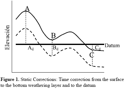
STATIC CORRECTIONS
Its objective is determine the arrival times of the reflections that could be observed if all measures were done on a flat datum without weathering layer. So, time corrections are applied to data recorded in A, B and C positions of figure 1 to convert them in traces that should be observed if the data were registered in Ad, Bd and Cd points on flat datum.
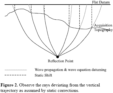
Static corrections estimation needs the replacement velocity, especially if there is a significant change in elevation or in the base of the LVL, a wrong value can produce false structures in the final section. The replacement velocity normally is determined from well data, seismic refraction or tomography. The conventional static corrections apply vertical time shift assuming the waves propagate almost vertically due to the high velocity contrast between the near surface and the substrate as seen in figure 2.
WAVE EQUATION DATUMING
The WED can be done through extrapolation methods as Kirchhoff Integral which is a solution of the acoustic wave equation, the integral equation corresponds to:

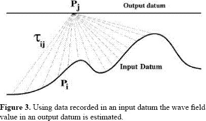
Pj is the scalar wave field propagating with velocity c Tij=r/c and is the time used to travel from Pi (x0, y0, z0) on the input datum to the point Pj (x, y, z) on the output datum. The objective is to calculate Pj for all times at point (x, y, z) on an infinite flat surface A0 as seen in figure 3. The wave equation datuming is a two-step process: first it is applied to all shot gathers and later to the receiver gathers, extrapolating shot and receiver gathers separately.
METHODOLOGY AND APLICATION
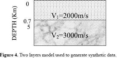
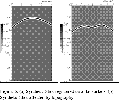
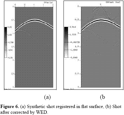
A synthetic dataset was generated in a two layers model (figure 4), 180 raw records with 25 m shot interval and 8 ms sample rate were obtained. The shots were upward continued to a rough surface through WED, simulating seismic data recorded in foothill zones, one of these synthetic shots is observed in figure 5a recorded on a flat surface and in figure 5b affected by topography. This dataset was created using a complete processing sequence in Seismic Unix (the Colorado School of Mines), because ProMAX does not include wave field continuation through Kirchhoff integral.
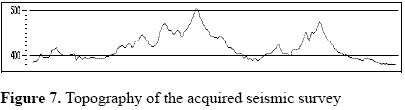
Then, the shots were continued to a plane datum. The shot 400 generate on the flat surface is observed in figure 6a, this shot affected by topography is shown in figure 5b and the shot after WED applied to eliminate the effects introduced by the topography is observed in figure 6b. Comparing figures 6a and 6b, it is noticeable the Kirchhoff integral performance to unravel the reflector.In the second step the WED approach was applied to a 2D seismic line of the Colombian foothill area, with 140 m of topographic variations as can be observed in figure 7, 12 km length, 240 channels, 344 shots, 15 m group interval and 15 m shot interval.
The line was processed using conventional sequence in ProMAX including filters, gain, amplitude recovery, static refraction, NMO, residual static to obtain finally a stacked section. The line was processed using a second processing sequence, but instead of use static corrections WED was applied using Seismic Unix (CWP-SU). The difference between the images provided by the two processing sequences is associated to this different step.
DISCUSSIONS
The raw shot 78 with geometry assigned is showed in figure 8, the same shot after applied static corrections is observed in figure 9 whereas the shot after applied WED is displayed in figure 10. Comparing the images in figures 9 and 10 it is noticeable the difference among them. In the figure 9 it is hard to appreciate any defined reflector, whereas in figure 10 several reflectors observed clearly around 1000, 1600, 2000 and 3000 ms, in addition other events with limited continuity are observed. Similar results were obtained in others shot gathers, confirming as expected, that the WED enhance the seismic information contained in a record acquired in zones with rough topography.
The stacked section furnished by the use of static corrections is showed in Figure 11, there some structures and reflectors are observed, giving an approximation of the geologic model in the zone. At the top-left part of the figure 11 a package of reflectors is observed which conforms the crest of an anticline, being visible until 800 ms. But below the anticline is hard to visualize other geologic features, except between 800 and 1500 ms where there are weak evidence of reflectors. At the central part of the image an anticline structure is seen and in the right part the image is unclear.
The stacked section of the figure 12 contains the stacked section obtained replacing WED instead of static corrections in the processing flow, where the reflectors of the left part are enhanced exhibiting a nice continuity also in deeper zone. The right part of the image displays more information content than figure 11, being notorious the anticline structure in the upper section that descends to create a syncline structure. Besides, some diffraction points are observed in this central zone indicating the existence of a fault described in previously done surficial geological reports.The presence in figure 11 of unidentified seismic signals crossing the section dipping in both left and right directions are strongly attenuated in figure 12, allowing to depict the geological structure of zone below the foothill zone.
CONCLUSIONS
In the conventional processing sequence, vertical static time shift is used to carry out sources and receivers to a flat datum, based in the assumption than the near surface velocity is smaller than the substrate, which is correct in some areas, where its use can correct the NMO curve distorted by the topography. However when the contrast is not great enough the ray path from substrate is not vertical. So, the conventional processing may conduce to wrong location of reflectors. The comparison between the shot gathers and the images obtained by the two considered approaches indicates that the application of WED to attenuate the effect introduced in seismic records by rough topography provides images with higher information content that those images furnished when static corrections are applied in this kind of zones.The NMO curves corrected by WED applications ensures that others methods based in this assumption can be correctly applied or others analysis like AVO provides information consistent with their own hypothesis. The stacked sections obtained with WED are structurally consistent diminishing the interpretation risk. Otherwise although the shot gathers provided by WED should be processed using a different flow sequence to obtain a clearer image, in order to compare the methods performance they were submitted to the same sequence. The wave field continuation method is a solution of the wave equation which allows to sources and receivers at whatever datum, without assumptions about the velocity contrast in shallow layers model. This method has into account the ray path when the velocity contrast between the substrate and the near surface is small, validating the Snell law.
REFERENCES
• Benxi Ke, Bo Zhao, Chaoying Liu and Yunfeng Fang. 2004 wave-equation datuming based on a single shot gather. SEG Expanded Abstracts Ann. Met.23, 2156. [ Links ]
• Berryhill, J. R., 1979, wave equation datuming. Geophysics 44, 1329-1344. [ Links ]
• Berryhill, J. R., 1984, Wave Equation Datuming before stack. Geophysics 49, 2064-2066. [ Links ]
• Bevc D.,1997, Flooding the topography: Wave equation datuming of land data with rugged acquisition topography. Geophysics 62, 1558-1569. [ Links ]
• Claerbout, J. F., 1985, Imaging the Earths Interior: Blackwell Scientific Publications. [ Links ]
• Gazdag, J., 1978, Wave equation migration with the phase shift method: Geophysics 43, pag. 1342-1351. [ Links ]
• Hindriks C. O. H. and Verschuur D. J. 2001, An imaging approach to complex near surface effects EAGE 2001 P-163 63rd Conference & Technical Exhibition -Amsterdam, The Netherlands. [ Links ]
• Malaver L. and Montes L. 2005. Elastic approach to remove surficial waves from shot gathers. Earth Sciences Researh Journal. Vol. 9. No. 1, 65-69. [ Links ]
• Montes L ,Vargas C and Pérez G. 2005 modeling and removal of back-scattered noise from rough topography in land seismic data, CT&F Vol. 3, Núm. 1, 131-138. [ Links ]
• Montes L., Quintana R., Cespedes S., Espíndola N., Salinas T. And Pérez G. 2003. Attenuation of the seismic dispersion associated to foothills topography: application to real data. CT&F Vol. 2, Núm. 4, 7-12. [ Links ]
• Reshef, M., 1991, Depth migration from irregular surfaces with depth extrapolation methods (short note): Geophysics 56, pag. 119-122. [ Links ]
• Yilmaz, O. and Lucas D. 1986. Prestack layer replacement. Geophysics 51, 1355. [ Links ]

