


Serviços Personalizados
Journal
Artigo
 Inglês (pdf)
 Artigo em XML
 Referências do artigo
 Enviar este artigo por email
Indicadores
-
 Citado por SciELO
 -
 Acessos
Links relacionados
-
 Citado por Google
 -
 Similares em
SciELO
Similares em
SciELO -
 Similares em Google
Compartilhar

 Permalink
Earth Sciences Research Journal
versão impressa ISSN 1794-6190
Earth Sci. Res. J. v.10 n.1 Bogotá jan./jun. 2006
Markéta Lednická1, 2 , Barbara Lunácková1 , Zdenek Kaláb1, 2 , Eva Hrubešová1 and Robert Korínek1
1 VŠB – Technical University of Ostrava, Faculty of Civil Engineering, L. Podeste 1875, Ostrava - Poruba, CZ-708 33, Czech Republic.2 Institute of Geonics of the Academy of Sciences of the CR, Studentska 1768, CZ-708 00 Ostrava - Poruba, Czech Republic.
Corresponding author: Z. Kaláb, e-mail: kalab@ugn.cas.cz
ABSTRACT
The study of seismic loading on buildings and structures caused by technical seismicity has intensified due to increase in loads. Loads are of interest not only for existing structures but they must be checked as part of an entire documentation project for new relevant buildings or for planned building reconstruction. The regions of Ostrava and Karviná were selected for study. The main reasons of our choice are the simultaneous occurrence of different types of technical seismicity: Mining induced seismicity, traffic vibrations, industrial activity effects, etc., and the existence of suitable structures for experimental measurement in this area. Individual buildings require different approaches for evaluation of their seismic load according to actual Czech technical standards.
The most suitable set for initial studies will be a group of selected buildings and structures meeting the most rigorous criteria for judging the seismic loading. Reliable measurements from analyzed buildings and structures are available for experimental work in the area. The number of places for experimental measurements will decrease after comparation with information of actual seismic loads caused by certain type of technical seismicity in this area. The result of this evaluation will be the so-called maps of clashes of opinions, which should help to choose the measurement area and suitable structures.
Key words: Technical seismicity, mining induced seismicity, seismic loading, building load.
RESUMEN
El estudio de cargas sísmicas en edificaciones y estructuras causadas por sismicidad técnica se ha intensificado debido al incremento en las cargas. Estas cargas son de interés no sólo para estructuras existentes sino que deberían ser revisadas como parte de un proyecto completo de documentación para construcciones nuevas e importantes o para planes de reconstrucción.
Para el estudio fueron seleccionadas las regiones de Ostrava y Karviná. Las principales razones para nuestra selección son la ocurrencia simultánea de diferentes tipos de sismicidad técnica: sismicidad inducida por minería, vibraciones por tráfico vehicular, efectos de la actividad industrial, etc., y la existencia de estructuras adecuadas para la medición experimental en el área. Los edificios individuales requieren diferentes aproximaciones para la evaluación de la carga por sismicidad, en concordancia con los estándares actuales de la República Checa.
El conjunto más apropiado para los estudios iniciales será un grupo de edificios y estructuras seleccionadas que cumplen con los criterios más rigurosos para la evaluación de la carga sísmica. Medidas confiables de edificios y estructuras analizadas están disponibles para el trabajo experimental en el área. El número de lugares para las medidas experimentales disminuirá luego de la comparación con la información referente a la carga sísmica real causada por cierto tipo de sismicidad técnica en esta área. Los resultados de esta evaluación serán los denominados mapas de opiniones controversiales, los cuales deberán ayudar a elegir el área de medición y las estructuras adecuadas.
Palabras Clave: Sismicidad técnica, sismicidad inducida por minería, carga sísmica, carga de edificaciones.
INTRODUCTION
The evaluation of seismic loading of buildings and structures is a very important topic. The main aim of this contribution is the presentation of a methodology for elaboration of the so-called “maps of clashes of opinions”. In this case, confrontation of information from different branches will create a new look of a solved problem. Seismic loading and parameters of buildings, both in close relation with selected place and time, are the basic input data. These maps of selected areas enable us to determine values of seismic loading for specific places and/or to detect probability of risk for evaluated buildings and structures caused by given seismic vibrations. The knowledge of effecting seismic loadings, (i.e. type of seismic events or vibrations and their intensities) is now an integral part of all project documentations. This is necessary not only for new buildings but also for extensive reconstruction of existing structures. Usually, values of velocity are used as the main criterion but values of motions, accelerations or response spectra are also applied. All reasonable input parameters that are influential in the behavior of buildings and structures, including intensity of seismic effects on the surface (e.g. Kaláb, 2004) need to be taken into account when maps of clash of opinions are to be prepared. In this contribution and discussion of the selection of these parameters and their inclusion into generating maps are discussed.
As an example, we selected the Karviná region. This area exhibits intensive seismic activity induced by mining activities (Kaláb & Knejzlík, 2002, Konecný et al., 2003, Holub, 2000), annually about 40,000 seismic events are recorded (from 100 to 500 seismic events have ML>1). Lot of sources of technical seismicity are also presented here, e.g. industrial seismicity or vibrations generated by traffic. Additionally, many interesting buildings and structures, including historical buildings and cultural monuments, are present in the Karviná area.
METHODOLOGY
The structure for developing the maps discussed is a design implementing GIS technology. Our first ideas for using of GIS in the solution of environment problems were presented formerly (Cápová 1997, Cápová & Kaláb 2002). First, we define the main terms that will be used here during the elaboration of maps of clashes of opinions. The main categories are (see also Figure 1):
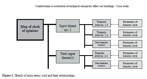
• Input theme.
• Thematic layer.
• Parameters of thematic layer.
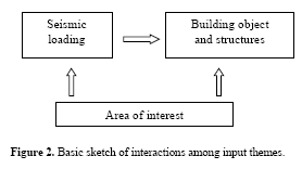
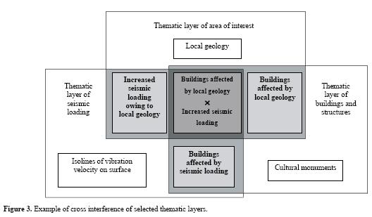
Three input themes will be included into our methodology for elaboration of maps of clashes of opinions in the topic presented here – seismic loading of buildings and structures in a given region: 1) selected region, 2) seismic loadings, and 3) building objects. Selected thematic layers with their characteristic parameters will be related to each of these three input themes. The thematic layers will be prepared in the form of map layers and they will be confronted with each other. A sketch of cross interference of all three input themes and cross-fade of thematic layers is presented in Figures 2 and 3. As is possible to see in Figure 3, subsets, which will be determined by specifi c behaviors and conditions (e.g.buildings or places), will be excluded from the basic set of input data as a result of the cross interference of individual thematic layers.
Elaboration of the individual thematic layers will be gradual depending on the available information quantity and complexity of data for the various themes and on fastidiousness during their preparation into the form of map layers. It is possible to compile maps of clashes of opinions at different scales:
• National
• Regional
• Local
• Detailed
Three input themes will be also the foundation for compilation of maps at different scales; however, individual the thematic layers will be different depending on the scale. It means that certain simplifi cation (or exclusion of thematic layers with very detailed information) must be accepted for maps with high values of ratio scales.
Due to complexity of the presented methodology at present we are only preparing maps with regional scale. Therefore, in this contribution a methodology for selection of thematic layers for regional maps will be presented.
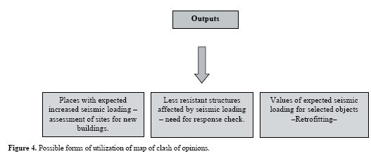
Maps with information about seismic loading of a given area depending on local conditions (geological, hydrogeological, etc.) and on buildings affected by seismic loading will be the main result of our elaboration (Figure 4). One basic output can then be data about expected natural seismic loading, its distribution in the studied area, and eventually values of technical seismicity (isolines of velocities). This information can be used for assessing the location of a new building, fi rst for buildings that need special conditions (e.g. technology industries sensitive to vibrations). The information about endangered structures and buildings that are sensitive to this type of dynamic loading will be the next possible outputs. Endangerment of structures is favored in specifi c conditions, such as unfavorable geological conditions, and increased surface seismic effect due to local geology.
Parameters of Input Themes and their Thematic Layers
Area of Interest
The area of interest is an output theme that encloses the region under study. Of course, the region parameters have direct infl uence on both input themes – seismic loading and engineered constructions and objects.
The selection of an area of interest can be made based on:
• Occurrence of sources of seismic vibrations.
• Request for individuals or organizations.
• Occurrences of structures those are less resistant
against loading – signifi cant buildings, endangered
buildings, or other type of structures.
The size of the selected region is related to the accuracy of processing. This means that if the selected region is small then obtained outputs will be more detailed. On the contrary, large regions will demand certain simplifications during the elaboration of individual themes. This is necessary because of the large volumes of input data, complex and subsequent processing.
Confrontation between seismic loading and infrastructure will result in the preparation of maps of clash of opinions. Most of parameters are closely bounded in space and time, therefore, the selection of parameters for thematic layers is very important. Some of these parameters can influence the effect of seismicity on the surface: effects can be enhanced or diminished; some others can influence buildings (foundation conditions, hydrogeological situation, etc.).
The methodology of creation of thematic layers for the area of interest will not be described in detail. Our presumption is that these thematic layers are available at present. In Czech Republic, many of the themes were prepared by the Czech Geological Survey – Geofond in Prague using GIS technology (Cápová, 2005).
Thematic layers of area of interest:
• Geology (local – depending on selected scale).
• Local tectonics.
• Depth to watertable.
• Accumulation of water on surface.
• Thickness of sedimentary layers.
• Deformation of surface due to underground mining.
• Undermined regions.
• Landslides and other dynamic events.
• Behavior of rock medium (Rheology).
Constructional Objects and Structures The methodology of elaboration of constructional objects and structures thematic layers will be described in detail because these thematic layers are not currently available and it is necessary to create them. The proposed maps must first confront buildings and structures with seismic loading. This methodology of processing of construction objects will be based on demands of current Czech Technical Standards for evaluation of seismic loading of objects. Now, there are standards for evaluation of natural seismicity (CSN 73 0036 or Eurocode 8) or technical seismicity (CSN 73 0040).
When evaluating the structured response during natural or technical seismicity we classify the buildings and structures according to their resistance class and/or their class of socio-economic significance (Czech Technical Standards 73 0031, 73 0036, 73 0040). The classification of objects into classes enables us to explore strength according to applied seismic loading. This classification will be the base for classification of structures in a given area and the subsequent creation of individual thematic layers.
There are six classes of resistance named from A to F. Class A includes unstable buildings, historical buildings, and buildings with extensive plastic décor, archaeological structures, and others. Class B is represented by common brick buildings, structure with ground area up to 200 m2 with a maximum of three stories. Class C contains good reinforced structures for panels, large brick buildings, stone bridges etc. Class D includes steel and concrete body structures, wooden and half-timbered houses, monolithic tank tower and others. Class E consists of concrete-steel buildings, steel constructions and steel towers; the most resistant structures, for example hold-out structures, represent Class F.
As follows from the classification presented above, the most rigorous postulates are determined for the class A: historical buildings and buildings that do not meet construction criteria. Building age is one of criterion that will have significant influence on the seismic response of structures affected by seismic loading. The main reasons for this are changes of behavior -strength properties of construction materials in time. Analysis of individual building ages in the area of interest will be necessary before creation of an adequate thematic layer. Certain subsets of these historical buildings will include cultural monuments. For many areas these lists are available. The reminder classes, B to F, will be divided depending on constructional and material behaviors that can constitute other thematic layers.
The standards mentioned above divide structures into four classes according to their socio-economic significance. These classes are named U, I, II and III. Individual classes respectively comprise structures and buildings with extraordinary, great, medium, and wee economic or social significance. Wherever we need classes with the most rigorous requirements, we will classify the studied structures into the U and I classes. These structures and buildings are of vital importance and damage to them could endanger the lives and health of many people or cause great cultural and physical damage. Class U structures include significant traffic structures, important bridges, dams, and other significant structures. Class I is represented by traffic constructions such as bridges, tunnels, highways, first and second-class roads, aerodrome routes, water service structures, headstocks, engine-rooms of winding engines, buildings with principal ventilators for gassy mines, structures for blast furnaces, high chimneys and antenna masts, tanks and reservoirs for chemical and oil products, and main structures of power stations. This class also includes buildings of civic amenities with high capacity to accord the people and lack evacuation routes, cinemas, theatres, hospitals, schools, supermarkets, waiting rooms, station halls, dedans, museums, government archives, observation towers and others.
Thematic layers of constructional objects and structures:
• Ages of buildings and structures.
• Cultural monuments.
• Technology construction: Monolithic structures, framed structure buildings, towers, etc.
• Used materials: brick, timber, steel, steel-concrete structures.
• Economic and social significance: objects in classes U or I.
Seismic Loadings
This input theme is the main term incoming into the creation of maps of clash of opinions. The main outputs will be simultaneously, information about general seismic loading of the area under study, i.e. types of loading and their intensity from these maps. The individual types of seismic loadings will be prepared as maps of thematic layers and than they will be confronted both with thematic layers of the area of interest, i.e. possible changes of intensity of seismic effect on surface, and with parameters of thematic layers of constructional objects and structures. Some of the thematic layers will be closely dependent on time due to the quick variability nature of some types of seismic vibrations.
Because of variability perhaps it will be necessary to elaborate for each type of seismic loading an individual thematic layer. Generally, the seismic loading is divided into two groups: natural seismic loading and loading generated by technical seismicity.
Detailed information about the first group is available at present. It is possible to use maps that are included in the Czech Technical Standards (see above); a first option is a map with isolines of intensity degrees (MSK-64), the second one are values for proposed acceleration of foundations. However, it will be necessary to elaborate thematic layers that represent individual types of vibrations generated by technical seismicity. We start from a basic classification of technical seismicity and its intensity.
Now, we propose this basic subdivision for technical seismicity:
• Induced Seismicity:
– Mining induced seismicity.
– Seismicity generated near high reservoirs.
– Seismicity generated by pumping or impression of medium.
– Weight of a big dumping hopper.
• Seismic events generated by an artificial source:
– Traffic.
– Quarry blasts.
– Pulsations of water jet.
– Industrial activities.
As stated above, the seismic loading caused by technical seismicity is strictly connected with self sources: industrial activities, vibration of engines, traffic of highways, roads, railways, and blasting operations, quarries, and induced seismicity, mining areas, dams. This fact will be used in the methodology of preparation of thematic layers of seismic loadings. Therefore, when we start with the idea to elaborate a thematic layer with certain type of technical seismicity, a first task will be to determine the source of vibrations including their intensity. The next task will be determining the impact of this source; it will be necessary to verify the seismic effect of a given source to document its influence on buildings and structures. Some of these layers can only be prepared after experimental measurements in a given area e.g. velocity isolines on surface generated by mining induced seismicity.
Themes of seismic loading:
• Intensity of natural earthquakes.
• Proposed acceleration of foundations.
• Sources of induced seismicity – undermined areas (actual or abandoned mines), reservoirs.
• Isolines of maximum velocity on surface (mininginduced seismicity).
• Sources of technical seismicity – intensity, range
impact.
CONCLUSION
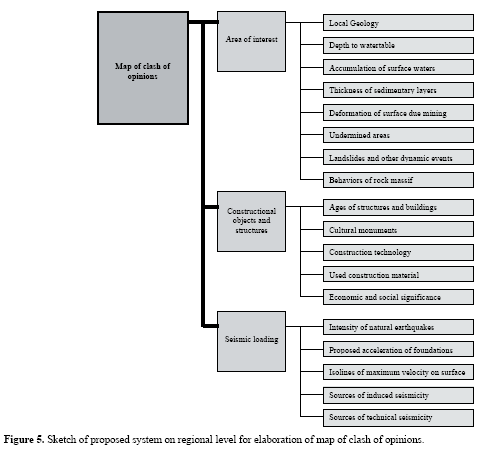
In this proposal of a methodology for creation of maps of clash of opinions is presented. A proper elaboration of maps under discussion will be a stepby step procedure depending on availability of input data and based on fastidiousness of their inclusion into a particular layer. Input provocation for creation of these maps results from the necessity of selection of representative buildings for completion of experimental measurements to obtain their seismic response. A sketch of proposed system on a regional level is shown on Figure 5.
A simple example of sequence of maps on a regional level in the Karvina area is shown in Figure 6.
Here, in the upper left a generalized estate map with demarcation of mining claims exploited for a long time; to the upper right part there is a map with demarcation of mining claims exploited for a long time completed by isolines of seismic loading by mining induced seismicity (summary information for 2004 in mm.s-1); in lower left part there is a map completed by main roads that are the main connection between big cities; and in lower right part there is a signed collision between densely populated areas and higher seismic risk.
ACKNOWLEDGEMENTS
This paper has been achieved with the fi nancial support of the Ministry of Education, Youth and Sports of the Czech Republic, Project no. 1M6840770001.
REFERENCES
• Cápová, D. (1997). MGE Tools used to help protect Czech environment, Global Links, Intergraph's International Mapping/GIS and Civil Letters. 3, no. 6. [ Links ]
• Cápová, D. (2005). Internet Site for Data on Geological and Geophysical Information System of Czech Geological Survey - Geofond, http://caag.geofyzika.cz/cz/Geofond_CAAG_soubory/frame.htm (in Czech) (last accessed August 2005). [ Links ]
• Cápová, D. and Z. Kaláb (2002). GIS Project to monitor induced seismic activity in areas of abandoned underground mines, Publs. Inst. Geophys. Pol. Acad. Sc. M-24, no. 340, 121-129. [ Links ]
• Holub, K. (2000). The influence of temporary mining interruption on induced seismicity, Acta Montana. Series A, 118, no.16, 61-70. [ Links ]
• Kaláb, Z. (2004). Impact of seismicity on surface in mining affected areas: general description, Acta Geodyn. Geomater. 1, no. 133, 35-39. [ Links ]
• Kaláb, Z., and J. Knejzlík (2002). Systematic measurement and preliminary evaluation of seismic vibrations provoked by mining induced seismicity in Karviná area, Publs. Inst. Geophys. Pol. Acad. Sc. M-24, no. 340, 95-103. [ Links ]
• Konecný, P., V. Velicka, R. Snupárek, G. Takla, and J. Ptácek (2003). Rockbursts in the period of mining activity reduction in Ostrava - Karviná coalfield, 10th Congress of the ISRM Technology roadmap for rock Mechanics, Johanesburg, South African, September, 665-668. [ Links ]
• Czech Technical Standard CSN 73 0036 (1973). Seismic loads of buildings, Czech Republic. [ Links ]
• Czech Technical Standard CSN 73 0040 (1996). Loads of technical structures by technical seismicity, Czech Republic. [ Links ]
• Czech Technical Standard CSN EN 1998-1 Eurocode 8 (1998). Design of structures for earthquake resistance, Czech Republic. [ Links ]

