


Services on Demand
Journal
Article
 English (pdf)
 Article in xml format
 Article references
 Send this article by e-mail
Indicators
-
 Cited by SciELO
 -
 Access statistics
Related links
-
 Cited by Google
 -
 Similars in
SciELO
Similars in
SciELO -
 Similars in Google
Share

 Permalink
Earth Sciences Research Journal
Print version ISSN 1794-6190
Earth Sci. Res. J. vol.10 no.1 Bogotá Jan./June 2006
Hernando Tavera1, Renzo Vilca2 and Gloria Marín3
1 Dirección de Sismología, Instituto Geofísico del Perú
2 Centro Nacional de Datos Geofísicos, Instituto Geofísico del Perú
3 Oficina Regional de Chiclayo (Perú), Instituto Geofísico del Perú
Corresponding Author: Hernando Tavera, e-mail: hjtavera@geo.igp.gob.pe
ABSTRACT
In Central and Southern Peru, local and teleseismic data allow having insights on the Wadati-Benioff zone (WBZ) geometry. In the region of Northern Perú, only rough estimates of the WBZ geometry have been proposed, and were obtained using teleseismic data due to the reduced number of mb≥4.0-magnitude earthquakes available. The installation of a local seismic network in the NW border of Northern Perú, allowed the recording of a large number of earthquakes with magnitudes ranging from 1.8 to 4.1 ML, and maximum depths of 120 km., distributed over the area where the occurrence of earthquakes with magnitudes > 4.0 is scarce. In a vertical section, oriented N70˚E earthquakes are distributed along a 10° dipping plane from the trench. Landwards from the coastline, the dip angle increases to 28°. These results allow a high resolution definition of the Nazca plate geometry in NW Perú. Focal mechanisms computed for 22 earthquakes located between 50 and 120 km depth beneath the network suggest the development of deformation processes in direction parallel to the convergence Nazca plate direction.
Key words: Nazca Plate, subduction, double seismic zone, Perú.
RESUMEN
En la región centro y sur de Perú, la geometría de la Zona Wadati-Benioff (ZWB) ha sido estudiada con el uso de datos locales y telesísmicos; mientras que, para la región norte, solo se han realizado análisis utilizando datos telesísmicos debido al escaso número de sismos con magnitudes mb≥4.0. La instalación de una red sismográfica en el borde NW de la región norte de Perú, ha permitido detectar un importante número de sismos con magnitudes ML entre 1.8 y 4.1, y profundidades máximas hasta 120 km, todos distribuidos sobre el área en donde la ocurrencia de sismos con magnitudes ML mayores a 4.0 es mínima. En una sección vertical orientada N70°E, los sismos se distribuyen en profundidad, desde la fosa siguiendo una pendiente de 10° y a partir de la línea de costa hacia el continente, el ángulo de inclinación aumenta a 28°. Estos resultados permiten definir con alta resolución la geometría de la placa de Nazca en el borde NW de la región norte de Perú. Los mecanismos focales calculados para 22 sismos ubicados por debajo de la red entre 50 y 120 km de profundidad, sugieren el desarrollo de diversos procesos de acomodación de movimiento en dirección paralela a la dirección convergencia de la placa de Nazca.
Palabras clave: Placa de Nazca, subducción, doble zona sísmica, Perú.
INTRODUCTION
The segment of the Andes, located west of Perú, is the result of a subduction process of the Nazca (NP) plate beneath the South American (SA) plate. In general, any major changes produced in the tectonics of the Cordillera are somehow related to comparable changes in the Wadati-Benioff (WBZ) zone geometry, (Kausel & Lomnitz, 1968 and Lindo, 1993). In Perú, recent studies on the WBZ geometry show the existence of a trench-normal subduction in the Southern region with the presence of active volcanic chains and a sub-horizontal subduction in the Northern and Central regions with absence of volcanic activity (Stauder, 1975; Barazangi & Isacks, 1979; Cahill & Isacks, 1992; Tavera & Buforn, 2001; Bernal & Tavera, 2002). These studies used teleseismic data drawn from the NEIC, and ISC catalogues, and recently from Engdahl catalogue (Engdahl et al., 1997). These catalogues, generally include mb>4.0-magnitude earthquakes, and if more detail on the subduction zone geometry is intended, the use of local (Δ<100 km) and regional (100<Δ<1000 km) data is necessary.
In Perú, studies on the WBZ geometry using data from local seismic networks have been carried out only in the central and southern regions, several 1- D and 3-D models have been proposed (Hasegawa & Sacks, 1981; Grange, 1984; Schneider & Sacks, 1987; Rodríguez & Tavera, 1991; Cahill & Isacks, 1992; Lindo, 1993 and Tavera & Buforn, 2001). In general, it is accepted that in the Southern region, the Nazca plate continuously subducts with a 30° dip angle down to about 300 km depth; while in the Central region, the plate subducts with an initial 10° dip angle from the trench to the coastline, increasing to a 30° dip to a depth of 120 km, and then becoming almost horizontal up to distances of 500 km from the trench. In the case of the Northern Perú, no studies on the WBZ have been carried out using local data, and up to date, the best results are those obtained from the teleseismic data (Stauder, 1975; Tavera & Buforn, 2001). Therefore, it has been suggested that the characteristics of the subducting plate are similar to those observed for the Central region. In Figure 1a, we show the seismicity map for the Northern region of Perú, with data from the Engdahl catalogue (1964- 1999, mb>4.5) and from the Instituto Geofísico Del Perú (2000-2003, mb>4.5). According to Figure 1a, shallow to intermediate earthquakes form two main groups: 1) The first group locates in front of the coast line where earthquakes probably occur along the subduction interface and 2) The second group located roughly beneath the city of Moyobamba, where the fault geometry is poorly known. In the centre of the study area beneath the Cordillera (third group, Figure1a), almost no earthquakes are observed, with only a few reported, and shallow and intermediate earthquakes located within the local network or near the trace of the Recodo fault.
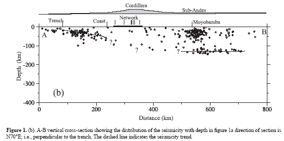
In a vertical section with orientation N70°E, parallel to the direction of plate convergence, it can be observed that earthquakes are distributed in depth forming two groups (Figure 1b), one is spatially associated with the subducting Nazca plate, and the other is formed by events probably occurring inside the overriding SA plate. The first group is likely associated with the plate interface and follows an apparent 20° dip angle from the trench towards the coastline. The absence of earthquakes is evident from 150 km to about 550 km distance (Figure 1b). Farther landward, the earthquakes form a nearly horizontal plane at 120 km depth up to 700 km distance. In Figure 1b, the dashed lines indicate the seismicity trend in the region. This low earthquake activity beneath the Cordillera has been observed and discussed by several authors (Stauder, 1975; Barazangi & Isacks, 1979; Cahill & Isacks, 1992; Tavera & Buforn, 2001), and is interpreted as consistent with the existence of a seismic gap.
Unlike the Central and Southern regions, limited information for the Northern region of Perú, has not allowed the characteristization of its shallow and intermediate seismicity, nor the WBZ geometry to be accurately defined. This study analyses the spatial distribution of the earthquakes in a long NW Perú during the 1996-2001 period. All these events were recorded by a local seismograph network composed of 8 short-period stations. The data reveal the presence of microseismicity and help to better define the WBZ geometry. Additionally, simple focal mechanisms were used to characterize the deformation pattern at the intermediate-depth levels.
DATA AND METHODOLOGY
Since 1996, a local seismograph network composed of 8 short-period stations (Figure 1a) have been operating NW of the Northern region of Perú. All these stations are equipped with Kinemetrics SS-1 vertical component seismometers with a Sismalp system 16-bit digital recorder (Frechet & Thouvenot, 2004). Time control is carried out with a GOES satellite and the signal is transmitted in real time, from each station, via a RF (UHF and VHF) telemetry system to a recording station located in the city of Chiclayo.
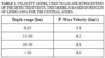
The hypocentral parameters for all earthquakes were obtained using a modified version of the computer program HYPOINVERSE (Klein, 1978) using a velocity ratio of 1.75±0.1 calculated with a total of 2014 P and S-wave arrival times. Considering that for the Northern region of Perú there is no published information on velocity models, we used the 1-D model proposed by Lindo (1993) for the microseismicity study of the Andean zone Central of Peru because the WBZ geometry is very similar (Table 1). In the hypocentral calculation, each event is located with different trial depths that range between 0 and 250 km with a 2 km interval, minimizing the dependence of the final hypocenter on the initial trial solution. The magnitude for each earthquake has been calculated with the record duration by using the relation proposed by Ccallo et al. (2002) for the short-period stations of the Red Sísmica Nacional del Perú.
During a 6-year period (1996-2001), the local seismograph network recorded a total of 1593 earthquakes with S-P time difference, equal to or lower than 30 seconds, all of them detected with more than 5 stations (5 P- and S-phases, respectively). In general, uncertainties of 0.1 s and 0.25 s have been estimated for the P and S arrival times, respectively. After calculating the hypocentral parameters for all earthquakes, those with RMS travel time residual <0.2 and horizontal (ERH) and vertical (ERZ) formally-computed errors < 2.5 km were selected. This database with the best located earthquakes has 547 events with (ML) magnitudes ranging between 1.8 and 4.1; most of them (~90%) recorded by 6 or more stations.
To evaluate the accuracy of the solutions obtained and analyze possible changes in epicentral coordinates and focal depths calculations were carried systematically varying and the values of Vp/Vs and the velocity models. In the worst case, changes of hypocentral were lower than 5 km, but in most cases those variations were smaller than 3 km. Such small variations are due to the special care taken to identify the P and S arrival times and to the accurate calculation of the Poisson relation based on the Wadati curve.
RESULTS AND DISCUSSION
Distribution of Hypocenters
The spatial distribution of the 547 selected earthquakes is shown in Figure 2, all of them are distributed within the study area and within coverage of the local seismograph network. Three groups of earthquakes can be distinguished in Figure 2: the first one is related to shallow-focus earthquakes (circles) distributed between the trench and the coastline. A second group of shallow-focus earthquakes is onshore mainly over the trace of the Recodo fault, a large fault in this region whose geometry details are not known. The third group is composed by intermediate-focus earthquakes (squares), distributed within and around the coverage of the local seismograph network. These earthquakes are mostly grouped around the four stations located north of the study area, and in general, cover all the area which in previous studies was thought to lack intermediate-depth earthquakes (Figure 1a).
In vertical sections oriented N70°E (Figure 3a), it could be observed that earthquakes are distributed following a mean alignment along a 10° dipping plane between the trench and the coastline, in agreement with the results of Tavera & Buforn (2001) obtained using teleseismic data. Approximately starting at the coastline, the dip increases to 28° with earthquakes reaching a depth of 120 km. Unlike previous studies carried out in this region using teleseismic data (Figures 1a and 1b), the distribution of the earthquakes detected by our local network accurately defines the WBZ geometry. At distances larger than 400 km east of the central Andes the hypocentral parameters are not well constrained, and are assumed to be distributed nearly horizontally at 120 km-depth, as observed in Figure 1b (dashed line).
The shallow-focus earthquakes located under the local seismograph network could correspond to deformations in the upper crust, since they usually have depths lower than 25 km. Eastwards of the local seismograph network, an important group of earthquakes, with depths reaching 40 km suggests the development of significant shallow deformation possibly associated to the Recodo fault (Figure 3a). At depth, these earthquakes do not show a clear trend; therefore, a detailed study of the Recodo fault seismicity with a larger network and better coverage is required. Six vertical sections oriented N70°E are shown in Figure 3b (see inset of Figure 2). It can be seen that the distribution of earthquakes does not show any significant lateral variations, suggesting that in the study area the Nazca Plate presents the same geometry.
Focal Mechanisms
The focal mechanisms of 22 earthquakes were calculated by using P-wave first-motion polarities. For each of these events, at least 5 impulsive P-wave polarity readings were selected. These earthquakes are distributed within the area of coverage of the seismograph network and represent a good sample of the intermediate-focus earthquakes in this study. Due to the small number of polarities, at least one of the nodal planes could not be constrained and for this reason we used a priori knowledge of the expected stresses to help constrain the nodal planes. In western Perú usually the principal stresses obtained from focal mechanisms of large earthquakes (mb≥5.0) are oriented in NE-SW direction, parallel to plate convergence (Stauder, 1975; Cahill & Isacks, 1992; Tavera & Buforn, 2001). The nodal planes were chosen so that the P (or T) axes were close to the N70°E direction (Appendix 1). According to Figure 2, the solutions obtained for the focal mechanisms are of inverse type (8 solutions) and normal type (14 solutions) suggesting that in the study area an heterogeneous stress field has developed, while results obtained from earthquakes with larger magnitudes show only mechanisms indicative of normal faulting.
Figure 4a shows the case of event 5 (see Figure 1a) for which the polarity of the P wave is well defined at all stations. Figure 4b displays the P waveforms recorded at five stations corresponding to events of comparable depth (see Figure 3c) and shows a clear change in polarity of the P wave. Those events were recorded by the same digital stations and have similar azimuths and take-off angles.
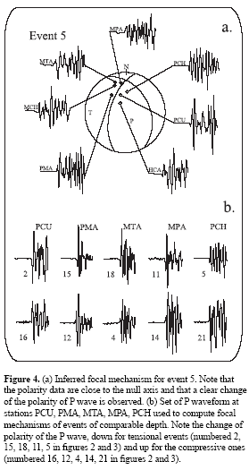
Figure 3b shows the depth distribution of the 22 earthquakes along with their focal mechanisms, showing the complexity of the deformation processes inside the plate, with the extensional-mechanisms events occurring above the compressional ones. This feature of a “double WBZ” has been observed in other subduction zones as Japan (Fujita & Kanamori, 1981; Igarashi et al., 2001) and Chile (Comte & Suarez, 1994; Comte et al., 1999; Rietbrock & Waldhauser, 2004) with a double zone of seismic events separated by roughly 10 to 25 km. In this study, because of the limited number of focal mechanisms available and to the little separation between the earthquakes with compressive and extensive processes, the presence of a double seismic zone could not be confirmed.
In general, the two families of focal mechanisms can be clearly separated as in Figure 3c. For both groups, the T and P axes are sub-horizontal and oriented along the NE-SW direction. The origin of such a complex pattern of deformation is poorly understood; Peacock (2001) and Wang (2002) suggested that tensional deformation could have its origin in dehydration processes in the subducting plate. At intermediatedepth levels, water is released by dehydration of ecoglite causing an increase in its density and further decrease of its volume inducing the stretching of the oceanic crust and possibly producing earthquakes (Kirby et al., 1996). Shortening may be induced by the stresses produced in the volume of the plate that controls its curvature. In this simple model it is the bending of the plate due to the subduction process that induces tensional (up-dip) and compressional (down-dip) stresses.
CONCLUSIONS
In a subduction zone, the spatial distribution of hypocenters and the characteristics of stresses, provide important information about geometry and local or regional deformation processes. For the NW border of the Northern region of Peru, the use of a local seismograph network during a 6-year period (1996-2001) enabled the identification of shallow or intermediate seismicity in an area where earthquakes of mb>4.0 earthquakes are rare. The data suggest a predominance of intermediate-focus earthquakes in the centre of the study area (beneath the Andes Cordillera).
At depth, earthquakes help to define the geometry of the subducting plate, which exhibits a 10° dip angle between trench and coastline, and 28° dip angle onshore down to 120 km depth. Beneath the Andes, the Nazca plate is horizontal and earthquakes have a mean depth of 120 km as suggested previously based on scarce teleseismic data (Stauder, 1977; Tavera & Buforn, 2001). The focal mechanisms for intermediate depth earthquakes beneath the local seismograph network suggest the development of complex deformation processes that could be attributed to small fracturing caused by stresses induced by the flexure of the subducting plate or alternatively dehydration processes.
ACKNOWLEDGEMENTS
We would like to thank The Geophysical Networks Team of the IGP that kept operational the local seismic network in the Northern region of Peru. This work has benefited from the critical reviews of Marcelo Assumpcao, Elisa Buforn, Diana Comte, Luis Quintanar, Hugo Perfettini, Natalia Ruppert and anonymous reviewer. This is IGP Contribution N°022-CNDG-IGP/2004.
REFERENCES
• Barazangi, M. and B. Isacks (1979). Subduction of the Nazca plate beneath Perú: evidence from spatial distribution of earthquakes, Geophys. J. R. Astr. Soc. 57, 537-555. [ Links ]
• Bernal, I., and H. Tavera (2002). Geodinámica, sismicidad y energía sísmica en Perú, Monografía CDNGSismología, Instituto Geofísico del Perú, Lima, Perú, 70 pp. (in Spanish). [ Links ]
• Cahill, T., and B. Isacks (1992). Seismicity and shape of the subducted Nazca plate, Jour. Geophys. Res. 97, 17503-17529. [ Links ]
• Ccallo, F., H. Tavera, and I. Valdivia (2002). La magnitud local y regional de terremotos ocurridos en Perú a partir de la onda Lg y la duración de su registro, Boletín de la Sociedad Geológica del Perú, 94, 61-69. (in Spanish). [ Links ]
• Comte, D. and G. Suarez (1994). An inverted double seismic zone in Chile: Evidence of phase transformation in the subducted slab, Science. 263, 212-215. [ Links ]
• Comte, D., L. Dorbath, M. Pardo, T. Monfret, H. Haessler, L. Rivera, M. Frogneux, B. Glass, and C. Meneses (1999). A double-layered seismic zone in Arica, Northern Chile, Geophys. Res. Lett. 26, 1965-1968. [ Links ]
• Engdahl, E., D. Vanderhilst, and R. Buland (1997). Global teleseismic earthquake relocation with improved travel times and procedures for depth determination, Bull. Seismol. Soc. Am. 88, 722-743. [ Links ]
• Frechet, J., and F. Thouvenot (2004). Pickev 2000: Software for seismogram picking and processing earthquakes to localization and mapping, Universite Joseph- Fourier and Centre Natural de la Recherche Scientifique, Observatoire Grenoble, France. [ Links ]
• Fujita, K., and H. Kanamori (1981). Double seismic zones and stress of intermediate depth earthquakes, Geophys. J. R. Astr. Soc. 66, 131-156. [ Links ]
• Grange, F. (1984). Etude sismotectonique detaille de la subduction lithospherique au Sud Perou, Ph.D. Thesis, IRIGM, Grenoble, France. [ Links ]
• Hasegawa, A., and S. Sacks (1981). Subduction of the Nazca plate beneath Perú as determined from seismic observation, J. Geophys. Res. 86, 4971-4980. [ Links ]
• Igarashi, T., T. Matsuzawa, N. Umino, and A. Hasegawa (2001). Spatial distribution of focal mechanisms for interpolate and intraplate earthquakes associated with the subducting Pacific plate beneath the northeastern Japan arc: A triple-planed deep seismic zone, J. Geophys. Res. 106, 2177-2191. [ Links ]
• Kausel, E., and C. Lomnitz (1968). Tectonics of Chile, M. Maldonado (Editor), Pan-American Symposium on the Upper Mantle, Instituto de Geofísica, México, 47-67. [ Links ]
• Kirby, S., R. Engdahl, and R Denlinger (1996). Intermediate-depth intraslab earthquakes and arc volcanism as physical expressions of crustal and uppermost mantle metamorphism in subducting slabs (overview), in Subduction: Top to Bottom, Geophys. Monogr. Ser. 96, 195-214. [ Links ]
• Klein, F. (1978). Hypocenter location program HYPOINVERSE, U. S. Geol. Surv. Open-File Rep. 78- 694. [ Links ]
• Lindo, R. (1993). Seismotectonique des andes du Perou central: Apport des donnes sismologiques de haute precision. Ph.D. Thesis, Universite Louis-Pasteur, Strasbourg, France. [ Links ]
• Machare, J., C. Fenton, M. Machette, A. Levenu, C. Costa, and R. Dart (2003). Database and map of Quaternary faults and folds in Peru and its offshore region, U.S. Geol. Surv. Open - File Report 03-451. [ Links ]
• Peacock, S. (2001). Are the lower planes of double seismic zones caused by serpentine dehydration in subducting oceanic mantle?, Geology, 29, 293-302. [ Links ]
• Rietbrock, A., and F. Waldhouser (2004). A narrowly spaced double-seismic zone in the subducting Nazca plate, Geophys. Res. Lett. 31, L10608, doi:10.1029/ 2004GL019610. [ Links ]
• Rodríguez, L., and H. Tavera (1991). High resolution determination of the Wadati-Benioff zone geometry in central Perú, Revista Brasilera de Geofísica, 9, 141-159. (in Spanish). [ Links ]
• Schneider, J., and S. Sacks (1987). Stress in the contorted Nazca plate beneath southern Peru from local earthquakes, J. Geophys. Res. 92, 13887-13902. [ Links ]
• Stauder, W. (1975). Subduction of the Nazca plate under Peru as evidenced by focal mechanisms and by seismicity, J. Geophys. Res. 80, 1058-1064. [ Links ]
• Tavera, H., and E. Buforn (2001). Source mechanism of earthquakes in Perú, Journal of Seismology, 5, 519- 540. [ Links ]
• Wang, K. (2002). Unbending combined with dehydration embrittlment as a cause for double and triple seismic zones. Geophys. Res. Lett. 29 (18), 1889, Doi:10.1029/ 2002GL015441. [ Links ]

