


Services on Demand
Journal
Article
 English (pdf)
 Article in xml format
 Article references
 Send this article by e-mail
Indicators
-
 Cited by SciELO
 -
 Access statistics
Related links
-
 Cited by Google
 -
 Similars in
SciELO
Similars in
SciELO -
 Similars in Google
Share

 Permalink
Earth Sciences Research Journal
Print version ISSN 1794-6190
Earth Sci. Res. J. vol.11 no.2 Bogotá July/Dec. 2007
GEOMETRIC MODEL OF THE NAZCA PLATE SUBDUCTION IN SOUTHWEST COLOMBIA
Patricia Pedraza Garcia 1, Carlos Alberto Vargas 1 and Hugo Monsalve J. 2
1 Maestría de Geofísica, Universidad Nacional de Colombia - Sede Bogotá, Colombia
e-mail: patriciapedrazag@gmail.com ; e-mail: cavargasj@unal.edu.co
2 CEIFI, Grupo Quimbaya - Universidad del Quindio, e-mail: hugom@uniquindio.edu.co
Manuscript recived March 13, 2007 . Acdepted for publication November 10, 2007
ABSTRACT
A geometric model for the subduction of the Nazca plate beneath the South American plate in southwestern of Colombia is proposed based on the relocation of hypocenters of local and distant earthquakes. By means of the simultaneous inversion of teleseismic P and SH body waves, we constrained the depths of the 15 events with Mw ³ 5.8 and relocated the hypocenters of the 250 earthquakes recorded between 1990 and 2005 by: the International Seismological Centre (ISC) and U.S. Geological Survey, National Earthquake Information Center (NEIC) were relocated. A model is proposed for the hypocentral sections taking into account the trench along of the Earth and Colombia-Ecuador. We obtained three different possible shapes of subduction of the Nazca plate in the Colombia-Ecuador trench: The first configuration, in the Cali A segment, the dip angle changes from17º to 45º down to a maximum depth of 100km, the second configuration, in the Popayán B and Nariño C segments the dip angle holds approximately constant at 30º down to a maximum depth of 200 km and the third configuration, in the Quito D segment the dip angle changes of 9º to 50º to a maximum depth 220 km . The maximum depth of seismicity along the Colombia-Ecuador trench shows two increases, first between latitudes 4.5ºN-5ºN and second between the latitudes 1ºS-2ºS, suggesting that the presence of the Malpelo and Carnegie Ridges may generate a differential blockage at the Pacific Colombia-Ecuador basin.
Key words: Seismotectonic, Nazca plate, subduction, Colombia .
RESUMEN
Se propone un modelo geométrico de la subducción de la placa Nazca bajo la placa suramericana en el suroeste de Colombia, basado en la relocalización de hipocentros de sismos locales y telesismos. Mediante la inversión simultánea de formas de ondas de cuerpo P y SH telesísmicas se ajustan las profundidades de 15 eventos con Mw≥ 5.8 y se relocalizan los hipocentros de 250 eventos con lecturas de fases registradas desde 1990 hasta 2005 por las agencias International Seismological Centre (ISC), y U.S. Geological Survey, National Earthquake Information Center (NEIC). Se propone un modelo de secciones hipocentrales teniendo en cuenta la curvatura de la Tierra y la curvatura de la Trinchera Colombia-Ecuador. Se obtienen tres formas distintas de subducción para la placa Nazca en la trinchera Colombia-Ecuador: La primera en el segmento Cali A, donde él ángulo de buzamiento cambia de 17º a 45º, a una profundidad máxima de 100km, la segunda en los segmentos Popayán B y Nariño C donde el ángulo de buzamiento es aproximadamente constante de 30º a una profundidad máxima de 200km y la tercera en el segmento Quito D donde el ángulo de buzamiento cambia de 9º a 50º a una profundidad máxima de 220km. La profundidad máxima de sismicidad a lo largo de la trinchera Colombia-Ecuador presenta dos aumentos, el primero entre las latitudes 4.5ºN-5ºN y el segundo entre las latitudes 1ºS-2ºS, sugiriendo la presencia de las dorsales de Malpelo y Carnegie que generan un bloqueo diferencial respecto a la cuenca del Pacífico Colombo-Ecuatoriano.
Palabras clave: Sismotectónica, placa Nazca, subducción, Colombia.
INTRODUCTION
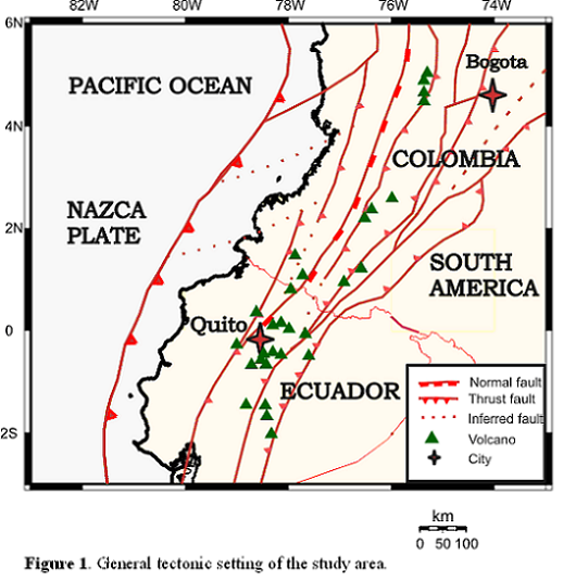
Southwestern Colombia is a region of enhanced tectonic activity resulting from the subduction the Nazca Plate (NP) beneath the South American plate (SA) along the Colombia-Ecuador Trench (CET). Several studies have shown that this subduction zone may exhibit lateral variations in the dip angle of the subducted oceanic lithospere as ell as changes in the distribution of seismicity along and down dip the trench, specially at intermediate depths (between the latitudes 3ºN-4ºN) where a seismic gap is apparent (Pennington, 1981; Taboada et al., 1998; Monsalve, 1998; Gutscher et al., 1999, Vargas et al., 2003, Mejía and Meyer, 2004, Chicangana, 2004).
Pennington (1981) obtained contours for the Wadati-Benioff Zone (WBZ) beneath northwestern South America and determined three segments with different directions and dip angles: the Bucaramanga segment from 5.2ºN to 11ºN, subducting in direction N109ºE and with dip of 20º-25º, the Cauca segment in the Colombia-Panama trench from 7ºN to 1.5ºN, subducting in direction N120ºE and dipping approximately 35º, and the Ecuador segment in the CET from 1.5ºN to 2ºS, subducting in direction N35ºE and a dipping approximatly 35º.
The direction of the Ecuador segment can be explained by a speculative model, that relates it to the activity of the Galápagos hot spot. This hot spot is located some 100 km to the south of the presently active Cocos-Nazca spreading center and could be subducting beneath the south of Ecuador near 1ºS-2ºS. This bathimetric feature could be the cause of the low subduction angle at the Peru-Ecuador border (Barazangi and Isacks, 1976). A more recent study made by Gutscher et al. (1999) shows a more complex behavior of the plate with the conclusion that the Ecuadorian system of subduction seems highly controlled by the subduction of the Carnige Ridge and by the rupture of the lithospere within the NP.
Mejía and Meyer (2004) based on the seismological information compiled by the Observatorio Sismológico del Suroccidente-OSSO propose a transition zone between active subduction and a possible blocked subduction by the addition of the Choco Block to the western coast of Colombia. Recent GPS measurements from the CASA project (Central and South America), reveal a wide plate boundary deformation with escape tectonics occurring along an approximate length of 1400 km of the North Andes, locking of the subducting NP and strain accumulation in the Ecuador-Colombia forearc (Trenkamp et al., 2004).
Associated with the process of subduction of the NP there is a volcanic arc, that extends from 5ºN (Cerro Bravo Volcano, Colombia) to 2ºS (Sangay Volcano, Ecuador). The SE active volcanism only reappears in Perú. The subducted oceanic crust, with ages between 12 and 20 Ma, is carrying the Carnegie Ridge, which is composed of volcanic products from the activity of the Galápagos hot spot on the NP and that has been subducting for at least 6 Ma. (Hey, 1977).
Data and methodology
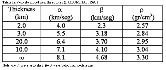
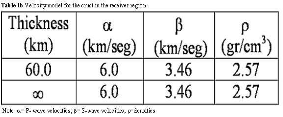
The purpose of this study is to determine the geometry of subducted NP, based on all the available and reliable locations of earthquakes recorded with local and teleseismic networks, and to explain the decrease in the intermediate-depth seismicity in southwestern Colombia . Initially some teleseismic events are constrained from the inversion of long-period body waves (Nabelek, 1984) these earthquakes are used as calibration events to relocate local events by means of the JHD method (Joint Hypocenter Determination, Dewey 1971).
Hypocentral cross-sections that are tipically presented as straight cross-sections in different studies at the Middle and South American Trenches (Isacks et al., 1968; Isacks and Barazangi, 1977; Pennington, 1981 Burbach et al., 1984, Vargas et al., 2003), but more recent works like those of Kawatsu (1986); Ekstrom and Engdhal (1989); Guzmán, S. (1995); Monsalve (1998), consider the arc-trench and Earth curvatures, demonstrating a better definition of the WBZ.
Data used in the inversion of body wave
Earthquakes of events with Mw≥ 5.8 reported by NEIC-USGS ( National Earthquake Information Center ) for period 1990-2005 were selected. The Digital registries of the teleseismic P and SH body waves were provided by IRIS-DMC (Incorporated Research Institutions for Seismology) agency.
Digital records of P and SH waveforms with periods between 1s and 100s were analyzed. The data used corresponded to waveforms recorded by broadband stations with a good azimuthal coverage located at distances from 30º to 90º to avoid the effects of the Earths core and upper mantle discontinuities on the waveforms. Figure 2 shows the location of the stations
used in this study. The instrument response was deconvolved from the traces, and the waveforms are integrated to obtain displacement amplitudes. The amplitudes were normalized for a magnification of the instrument equal to one and an epicentral distance of 40 degrees in order to unify the data.. The waveforms are band-pass filtered with a three pole Butterworth filter with cutoffs at 0.01Hz and 1Hz to eliminate long and short period noises respectively.
Data used in the relocated
We relocated earthquakes with magnitude m b ³ 3.5 in southwestern of Colombia , using the JHD method (Dewey, 1971) and the phases readings reported by ISC and NEIC between 1990 and 2004.
The JHD method determines the location of a set of earthquakes, applying time adjustments with a least squares estimation for the P, pP and S phase readings, using the time interval between pairs of phases . The 2004 Pizarro-Colombia earthquake, (Mw=7.2) was used the calibration event and 14 earthquakes with fixed depths by means of a teleseismic body waveform inversion.
RESULTS AND DISCUSSION
Body waveform inversion
In this study, 15 events with magnitude Mw ³ 5.8 reported between 1990 and 2005 were modelled, these earthquakes are most representative of the seismicity in the Colombia-Ecuador zone and cover in a relatively homogenous way the subduction zone Colombia-Ecuador. 10 of the selected earthquakes have shallow hypocentral depths (h £ 70km), 1 earthquake has intermediate hypocentral depth (70km £ h £ 140km), and 4 earthquakes have deep hypocentral depth (h>140km). An example of the focal mechanisms, waveform and source time functions modelled are shown in Figure 2
Hypocentral sections
By means visual inspection, two arcs along the CET were identified (Figure 1), the first one is concave towards the ocean and it extends approximately from 78ºW to 79ºW in a NW-SE direction, in front of the Colombia-Ecuador boundary, the curvature center is roughly located at 6.387ºN, 82.781ºW, at a distance of approximately 504km, the second one is concave towards the continent with the same general NW-SE direction, and goes from 79ºW to 81,6ºW to the southeastern end of the study zone, the center of curvature is located at 4.016ºS, 69.984ºW at a distance of approximately of 723km.
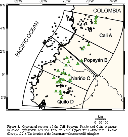
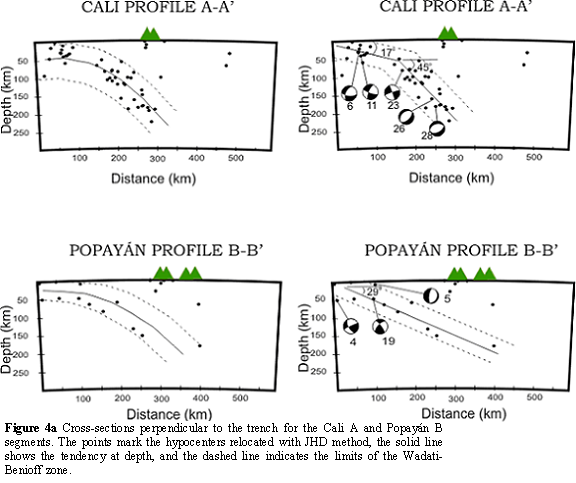
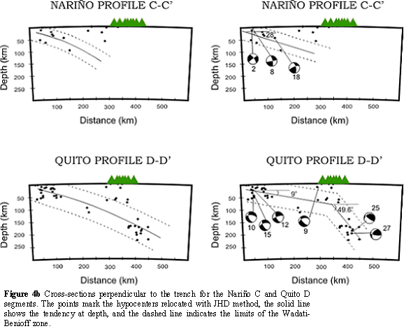
According to the distribution of the seismicity, four hypocentral cross sections were proposed (Figure 3). Perpendicular hypocentral projections and along the arc were done following the propose methodology by Guzman, S (1995) (Figures 4a, 4b). The position of the trench in cross-section view is always located in the upper-left corner of the section.
Focal mechanims
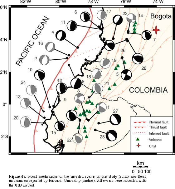
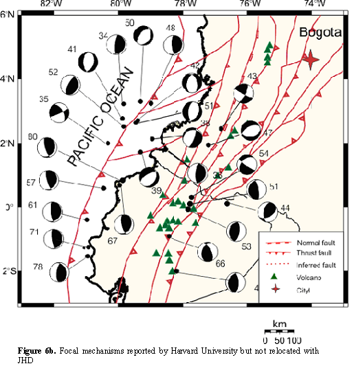
In this study, 15 focal mechanisms are modeled by means of inversion of P and SH body waveform and 14 mechanisms are CMT solutions reported by Harvard University , all events were relocated with the JHD method (Figure 6a), these focal mechanisms are also shown on lateral projections on the cross sections (Figure 4ay 4b). In Figure 6b, the focal mechanisms reported by Harvard University (but not relocated) are shown.
In a manner analogous to the seismicity, the stress pattern observed along the subduction zone may be divided in three zones: Two zones where the mechanisms correspond to compressional regime (thrust faulting), the first one, from 5ºN to 4ºN and the second one from 1.5ºN to 2ºS, and a third zone from 4ºN to 1.5ºN where a variety of mechanisms are observed: Normal, thrust and strike-slip, something unexpected for shadows subduction. A possible explanation to this behavior is a folding of the subducted plate due to a blockage possibly caused by the subducted Malpelo and Carnegie Ridges within the Cali A and Quito D segments respectively.
The intermediate seismicity is scarce and only two focal mechanisms are obtained (Numbered 23 y 24), the first one corresponds to normal faulting and located at 4ºN in front of Buenaventura, Colombia, and the second one corresponds to inverse faulting and is located at 0.5ºS in front of Manta, Ecuador. The deep earthquakes are concentrated in two regions, some in the north zone between 4ºN and 5ºN and some others between 1ºS and 2ºS. For the first cluster, the focal mechanisms of two events (numbered 26 and 28) are obtained both mechanisms correspond to thrust faulting with some strike-slip component, with depths ranging from 180km to 230km. Iin this region tensional movements would be expected, therefore, this rupture patterns could be due to the presence of asperities that generate traction on a subducted slab. In the second cluster, the focal mechanisms of two events (numbered 25 and 27) are obtained and both mechanisms correspond to normal faulting.
Geometry of the subducted plate
The WBZ shows changes in its dip and maximum depth in all four segments. For the Cali segment a change in the dip angle is considered down to a depth of 100km, to a width of approximately of 180km of trench beneath the continent, it increases from 17º to 45º. A maximum depth of 220km is estimated (Figure 4a y 4b). In the Popayán B segment the dip of the WBZ decreases to 30º and reaches a maximum depth of 190km. For the Nariño C segment the dip angle is similar to that of the Popayán B segment and with a maximum depth of 115km. In the Quito D segment the dip angle increases of 9º to 49,5º a depth of 100 km to a width of approximately 320km of trench beneath the continent and to maximum depth of 220 km .
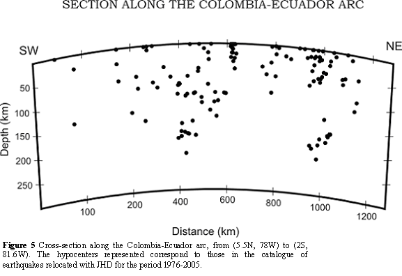
A cross section parallel to the trench, from (5.5ºN, 78ºW) to (2ºS, 81.6ºW) shows rapid variations in maximum depth of the hypocenters within southwestern Colombia (Figure 5). Two maximum depth zones are observed that correspond to the Cali A and Quito D segments, the maximum focal depth is 220 km . The depth extents of various segments of the subduction zone directly correlate with the observed dip of the slab.
Two transition zones are observed which suggest a steep change in dip angle. The first zone at 4ºN is within the Cali A segment and the second zone at 2ºS is within the Quito D segment. In the central part of the CET (3,5ºN to 1ºS) a seismic gap for intermediate and deep earthquakes is observed and the dip of the subducted slab becomes shallower (Figure 7a).
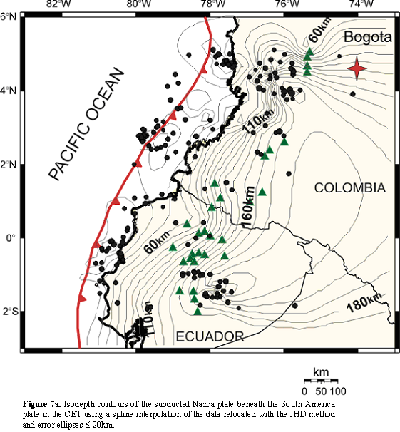
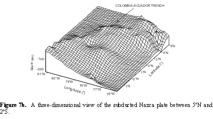
In the Figure 7b a perspective view of the WBZ is shown, which is intended to demonstrate the three dimensional complexity of the Nazca plate subduction in the CET. This three-dimensional surface was obtained by means of interpolation of the isodepth contours.
Several authors have suggested that the principal factors affecting the geometry of a subduction zone are the relative convergence rate, the age of the subducted slab, the absolute motion of the overriding plate, and the subduction of aseismic bathymetric features, like ridges or intraplate seamounts (e.g., Jarrard, 1986, Gorvatov and Kostoglodov, 1997).
When comparing the ages calculated using to the empirical relations given by Gorbatov et al, (1997) with the ages reported by Atwater, (1989), the values of age for the Popayán B 28± 1 m .a. and Nariño C segments 17± 3 m .a. are within the margin of 95% of confidence of the Gorbatov relation, but the values of age for the Cali A segment 46 ± 8 m .a. and for the Quito D segments 58 ± 7 m .a. are almost twice as large, these are precisely the segments that present changes in focal mechanisms. This situation can be explained with two hypothesis: 1-The calculated ages are the result of bias in the velocities or dip angles estimated in the present study. 2- The presence of the Malpelo and Carnegie Ridges generate differentials blockages with respect to the Colombo-Ecuatorian Pacific Basin , causing changes in the velocities of convergence in these regions.
The second hypothesis aggress with the measured vectors of convergence determined by GPS (Trenkamp et al., 2002) that show a change in the north component of the convergence velocities from south to north of the CET.
Other authors propose a overlap zone of the Caribbean and Nazca plates located between 5,2ºN y 7ºN in Colombia (Taboada et al., 2000). This model would explain the pronounced curve that appears in the isodepth contours in the Cali A segment between 3.5ºN-5ºN (Figure 7a). Gutscher et al., (1999) interpret the seismic gap at intermediate depths to the north of Ecuador between 0ºN and 1ºS to the subduction of the Carnegie Ridge and the changes in the dip angle in the Transition zones as tearing of the Nazca plate.
CONCLUSIONS
The body waveform inversion of 15 telesismic events and the relocation of 250 hypocenters detected during more than 30 years, allowed an approach to the problem or determination of the geometry of the Wadati-Benioff Zone, with a boundary in isodepth contours in the Colombia-Ecuador Trench.
The CET was constrained by means of Euler poles to two segments with different concavity, the first one, concave towards the Pacific Ocean located between 5ºN and 3.5ºN and the other one concave towards the continent between 3.5ºN and 2ºS. Two hypocentral sections for each segment were considered.
The subduction process of the Nazca plate beneath the South America plate is constrained from the seismicity distribution within the CET. Three different subduction configurations were observed: The first in the Cali A segment, with maximum depth of 290km to 300km up to a distance of 300km from the trench and a dip angle that changes of 17º to 45º to a depth of 100 km . The second in the Popayán B and Nariño C segments with maximum depth from 130 km to 150 km up to a distance of 280km from the trench and an approximately constant dip of 30º. The third in the Quito D segment with a maximum depth of 200km to 220km up to a distance of 430km from the trench and a dip angle that change from 9º to 50º to a depth of 80km.
The maximum depth of seismicity of the subducted slab in the CET showss two regions of increases, the first one, from 4,5ºN to 5ºN and the second one, from 2ºS to 1ºS. We suggest that the presence of Malpelo and Carnegie Ridges generated a differential blockage with respect to a Colombia-Ecuatorian Pacific Basin .
We suggest that the presence of Malpelo and Carnegie Ridges generated a differential blockage with respect to a Colombia-Ecuatorian Pacific Basin .
REFERENCES
1. ATWATER T. (1989). Plate tectonic History Northeast Pacific and Western North America . The Geology of North America . V. N, the Eastern Pacific Ocean an Hawaii. The Geological society of America , chapter 4. [ Links ]
2. BARAZANGI, M and ISACKS, B.L. (1976). Spatial distribution of earthquakes and subduction of the Nazca Plate beneath South America. Geology, 4. p. 686-692. [ Links ]
3. BOUCHON, M. (1976). Teleseismic body wave radiation from a seismic source in a layered medium, Geophys. J. R. Astr. Soc., 47. Pag. 515-530. [ Links ]
4. BURBACH, G.V., FROHLICH, C., PENNINGTON, W.D. and MATUMOTO, T. (1984). Seismology and tectonics of the subducted Cocos plate. Journal Geophysical Research, 89. p. 6153-6170. [ Links ]
5. CHICANGANA, G. and VARGAS, C. (2004). Desarrollo y Geometría actual de la Litosfera en la Esquina Noroccidental de Suramérica: First Latin -American Congress, Mem. (In CD - Room). [ Links ]
6. DEWEY, J.W. (1971). Seismicity studies with the method of join hypocenter determination: Ph.D thesis, University California, Berckeley. [ Links ]
7. EKSTROM, G. And ENGDAHL, E. (1989). Earthquake source parameters and stress distrrbution in the Adak island region of central Aleutian is-lands, Alaska. Journal Geophysical Research, 94. Pag. 15499-15519. [ Links ]
8. FUTTERMAN, W. (1962). Dispersive body waves. J. Geophysics Res., 67, 5279 -5291. [ Links ]
9. GORBATOV A; KOSTOGLODOV, V. (1997). Maximumdepth of seismicity and Thermal parameter pf the subducting slab:n general empirical relation and its application. Tectonophysics, 277. p. 165-187. [ Links ]
10. GUTSCHER, M.A., MALAVIELLE, J., LALLEMAND, S. and COLLOT, J.Y. (1999). Tectonic segmentation of the North Andean margin: impact of the Carnegie Ridge collision. Earth and Planetary Science Letters, 170 (1-2). Pag. 155-156. [ Links ]
11. GUZMÁN, S. (1995). Hypocentral cross-sections and arc-trench curvature. Geofísica International, V. 34, No 1, 131-141. [ Links ]
12. HEY, R.N. ( 1977). Tectonic Evolution of the cocos-Nazca spresding center, Geol. Soc. Am Bull, 88, Pag. 1404-1420. [ Links ]
13. INGEOMINAS. (1993) Boletín trimestral Junio-Agosto. bending of the subducted lithosphere, In: M. Talwani and W.C. Pitman II Editors, Island arcs, deep sea trenches and back-arc basins. American Geophysical Union. Washington, 470pp. [ Links ]
14. ISACKS, B., . OLIVER J and SYKES L. R. (1968). Seismology and the new global tectonics. J. Geophys. Res., 73. Pag. 5855-5899. [ Links ]
15. ISACKS, B.L. and M. BARAZANGI. (1977). Geometry of Benioff zones: Lateral segmentation and downward [ Links ]
16. JARRARD, R. (1986). Relations Among Subduction Parameters. Review of Geophysics. V. 24 pag. 217-284. [ Links ]
17. KAWATSU, H. ( 1986). Downdip tensional earthquake beneath the Tonga arc: A double seismic zone. Journal Geophysical Research, 91, 6432-6440. [ Links ]
18. MEJÍA, J. A and MEYER, H. (2004). Modelo detallado preliminar de la sismicidad en el occidente de Colombia. Observatorio sismológico del SurOccidente. OSSO. Memorias I congreso latinoamericano de Sismología. Armenia. [ Links ]
19. MOSALVE, J. H. (1998). Geometría de la subducción de la Placa de Nazca en el noroeste de Colombia: Implicaciones tectónicas y sísmicas. Tesis de Maestría. Instituto de Geofísica UNAM. 107p. [ Links ]
20. NÁBELEK, J. L. (1984). Determination of earthquake source parameter frominversion of body waves. Thesis doctoral, Massachusets Institute of Technology. [ Links ]
21. PENNINGTON, W.D. (1981). Subduction of the eastern Panama basin and seismotectonics of Northwestern South America. Journal Geophysical Research, V. 86, 10753-10770. [ Links ]
22. TABOADA, A. DIMATÉ, C. y FUENZALIDA, A. (1998). Sismotectónica de Colombia: deformación continental activa y subducción. Física de la Tierra. Madrid, No. 10. Pag. 117-147. [ Links ]
23. TABOADA, A., RIVERA, L., FUENCALIDA, A., CISTERNA, A., PHILIP, H., BIJWAARD, H., OLAYA, J. and RIVERA, C. (2000). Geodynaics of the northern andes: Subductions and intracontinental deformation ( Colombia ). Tectonics. Vol. 19. No 5. Pag. 787-813. [ Links ]
24. TRENKAMP, R., KELLOGG, J., FREYMULLER, J. and H. MORA. (2002). Wide plate margin deformation, southern Central America and northwestern South America. CASA GPS observations. Journal of south American Earth Sciences, 15, 2 p. 157-171. [ Links ]
25. TRENKAMP R., MORA, H., SALCEDO, E. and KELLOGG, J. (2004). Possible Rapid Strain Accumulation Rates near Cali, Colombia, determined from GPS measurements (1996-2003), Earth Sci. Res. J. 8 (1), 25-33 [ Links ]
26. VARGAS C.A., PUJADES LL.G., UGALDE A. y CANAS, J. (2003). Tomografía Sísmica Local del Territorio colombiano. Revista Internacional de Métodos Numéricos para Cálculo y Diseño en Ingeniería. Barcelona, v. 19, n. 3, p. 255 - 278, 2003 [ Links ]

