


Servicios Personalizados
Revista
Articulo
 Inglés (pdf)
 Articulo en XML
 Referencias del artículo
 Enviar articulo por email
Indicadores
-
 Citado por SciELO
 -
 Accesos
Links relacionados
-
 Citado por Google
 -
 Similares en
SciELO
Similares en
SciELO -
 Similares en Google
Compartir

 Permalink
Earth Sciences Research Journal
versión impresa ISSN 1794-6190
Earth Sci. Res. J. v.13 n.1 Bogotá ene./jun. 2009
MAGNETIC AND PALAEOMAGNETIC STUDIES AS AN AID IN DECIPHERING GROUNDWATER FLOW: A CASE STUDY FROM DECCAN TRAPS
S.K.G. Krishnamacharyulu1 and G.V.S. PoornachandraRao2
1 School of Earth Sciences, SRTM University, Nanded -431 606, Maharashtra, India
2National Geophysical Research Institute, Hyderabad - 500 007, Andhra Pradesh, India
Email: skgkchary@gmail.com, gvsprao@rediffmail.com
Manuscript received: January 02th, 2009. Accepted for publication: June 10th, 2009.
ABSTRACT
This paper reports the utility of palaeomagnetic investigations first time in the ground water studies. The magnetic anomalies along with palaeomagnetic studies are used to locate barriers obstructing groundwater flow in a basaltic terrain. Magnetic anomalies in an area of around 4 sq. km in the university campus, Nanded, Maharashtra, India brought out two distinct anomaly closures that can be attributed to bodies with different directions of magnetizations. Palaeomagnetic investigations reveal that the basalts are almost uniformly magnetized, asserting that the anomalies come form the subsurface and the anomalous sources are attributed to weathering of basal basaltic flows. The difference between the measured palaeomagnetic directions of the surface rocks and the observed magnetic anomalies, in corroboration with local geomorphologic conditions and the nature of the basaltic flows in thin basaltic terrains suggest that subsurface weathering plays a major role in the ground water movement. This paper presents a novel idea on the utilization of the palaeomagnetic studies coupled with ground magnetic anomalies in deciphering groundwater flow.
Key words: ground water, palaeomagnetic, magnetic anomalies
RESUMEN
Este artículo reporta por primera vez, la utilidad de las investigaciones paleomagnéticas en el estudio de aguas subterráneas. Las anomalías magnéticas junto con estudios paleomagnéticos se usan para localizar barreras que obstruyen el flujo de aguas subterráneas en terrenos basálticos. Las anomalías magnéticas observadas en un área de 4 km2 del campus de la Universidad STRM en Nanded - Maharashtra, India, indicaron dos cierres anómalos atribuidos a sendos cuerpos con diferentes direcciones de magnetización. Las investigaciones paleomagnéticas revelaron que los basaltos fueron magnetizados casi uniformemente, lo cual indica que las anomalías provienen del subsuelo y que las fuentes anómalas se atribuyen a flujos basálticos basales meteorizados. La diferencia entre las direcciones paleomagnéticas medidas en el afloramiento y las anomalías magnéticas observadas, corroboradas con condiciones geomorfológicas locales y con la naturaleza de los flujos basálticos en laminas delgadas, sugieren que la meteorización del subsuelo juega un papel clave en el movimiento de aguas subterráneas. Este artículo presenta una idea novedosa para el uso de estudios paleomagnéticos conjuntamente con anomalías magnéticas para descifrar flujos en aguas subterráneas.
Palabras Claves: aguas subterráneas, paleomagnetismo, anomalías magnéticas.
Introduction
The utility of magnetic method in ground water studies, although limited, to trace the floor of the basins or locating the structures that obstruct or control the groundwater flow is well known. However, palaeomagnetic investigations with unchallenged contributions to calculate the pole positions, to construct the history of the Earth's magnetic field and to decipher the plate motions were never sought after in groundwater investigations. In an aimed finding the clues for anomalous quantities of groundwater in a localized area, the palaeomagnetic data is found to be of utmost value to supplement the magnetic anomalies in identifying the barriers obstructing the groundwater flow. This paper presents the case study of this investigation, where the palaeomagnetic studies are utilized probably for the first time in ground water studies.
Geology and location of the area
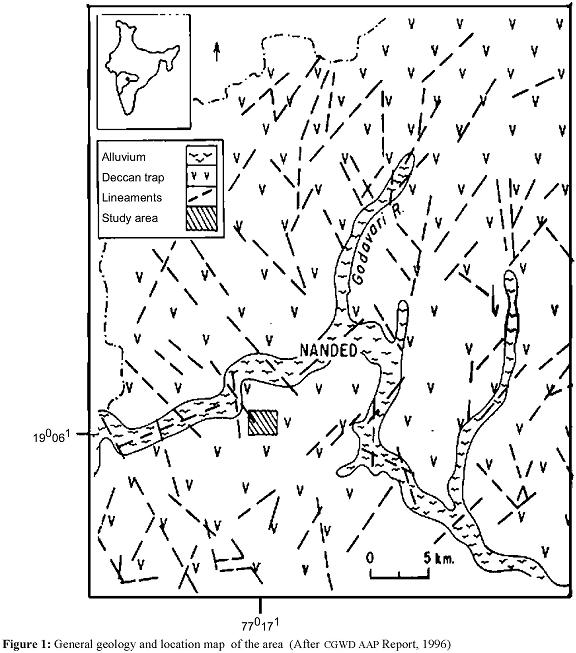
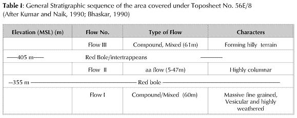
Figure 1 presents location and general geology of the area. The area lies in the toposheet no. 56 E/8 of Survey of India (190 061N & 770 171E) on the banks of river Godavari. The area is covered with Deccan lava flows with exposures of massive and columnar-jointed basalt, which believed to be erupted during Cretaceous-Eocene period over the Precambrian basement rocks. In general, this area comprises of three flows (Kumar and Naik, 1990; Bhaskar, 1990). Approximately 60m thick flow I is of compound pahoehoe type and highly weathered, exhibiting fragmentary tops at some places. This flow I is over-lain by columnar aa type flow II. The present area is exposed with many columnar basalts. Flows III, is a massive basalt exposed in limited places as hillocks. In this area, the elevated places are typically covered by massive basalts, while low relief areas are covered by columnar basalts. Table I shows the general stratigraphic sequence of the region and the present study area represents flow II with exposures of columnar basalts. Mostly the ground water in this region is in the fractures and vesicular basalts. The water bearing capacity of the vesicular basalt largely depends on the size and percentage of vesicles, density and degree of interconnection. Generally pahoehoe flows exhibit good porosity and permeability with uniform vesicles. In the Massive compact basalts the weathering, fractures, joints, shearing leads to secondary porosity. The pre- trappean topography of this area was irregular and the lower flows are abutting against the hillocks of the pre-trappean period (Raychaudhuri et al., 1984).
Foote (1876) reported rude massive blocks at basal basaltic flows formed due to weathering. According to him the massive blocks are common striking features in thin basaltic layers particularly in the margin areas of the Deccan basalts and decomposition of the trap rocks under certain circumstances gives rise to eminently clayey products containing large percentage of iron.
Several E-W joints/fractures were identified from photo-interpretation, showing the curvilinear nature on the ground. The Godavari River in this region presents a corrugated shape with U turns and right angle bends The Central Ground Water Department identified three sets of lineaments in this area in NW-SE, N-S and almost E-W directions. (Fig.1; CGWB AAP report, 1996).
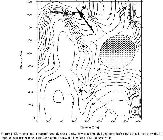
The elevation map of the area is presented in figure2. There is a geomorphic denuded feature in approximately E-W direction (shown by arrow in figure 2), flanked by columnar massive basalts to the North and South, corresponding to flow II. A perennial lake forming cal de sac to this denuded feature can be seen on the eastern side (figure 2). Hydrogeologically this is supposed to be a highly favourable condition for the groundwater. However, the existing bore wells (shown as Star symbol in figure 2) in this area established only poor supply of groundwater. The bore wells went up to a depth of around 70 m. Some open wells dug up to a depth of around 10-15 m within the top flow produce some water. This paper is an attempt to find out the probable cause for the obstruction of the ground water in the subsurface formations.
Magnetic Survey and Anomalies:
To investigate the anomalous behaviour of the bore wells on the EW denuded area, a magnetic survey was conducted covering an area of approximately 4 sq.km. Figure 3 shows the observed total field magnetic anomaly map with a station spacing of 200m. The magnetometer used in this study is a Proton Precession Magnetometer of EG & G Geometries, Canada, with a reading accuracy of 1 gamma. The magnetometer readings were corrected for the Earth's normal field and diurnal variation by making repeated measurements at a chosen base station

The magnetic anomaly map shows two conspicuous pairs of positive and negative magnetic anomaly contour clusters. These two anomalous zones show almost a similar range of anomalies, with -1400 nT to 2500 nT on the northern anomalous zone and -2200 nT to 1600 nT on the southern zone; but they exhibit different trends, one in almost N-S direction and the other in E-W direction. Since the interest is to have the order of the depths, two-dimensionalmodel-ing is attempted though the anomaly pattern suggests a three-dimensional nature. Two profiles AA and BB, one from each anomalous zone for quantitative interpretation. Various models tried using the algorithm developed by Radhakrishna Murthy (1998) and found that the dyke model is best-fitted model for these profiles. It is observed that for this model the objective function is minimum and the fit between observed and calculated anomalies is good. The interpretation revealed that the anomalous bodies are situated at depths of 37 m and 40 m respectively under AA and BB. While the intensity of magnetization needed for both is almost the same, the directions of magnetization differ: the values being -74 and 172 degrees respectively. The lava flows of same age are expected to show same magnetization and hence these values are attributed to subsurface features altered probably due to weathering. Further the calculated depth values interestingly correspond to the base of the top flow and clearly rule out the possibility of the anomalies coming form the magnetization changes within the top flow. To further rule out of this possibility, twenty two oriented rock samples from the surface were collected from the exposed rock units covering both the anomalous zones, and were subjected to palaeomagnetic and rock magnetic studies.
Rock magnetism and Palaeomagnetism
Cylindrical specimens of standard dimension were drilled from the oriented samples and their Natural remnant Magnetism (NRM) was measured using a Spinner Magnetometer (Model DSM-2, Schonstedt, USA)atNGRI, Hyderabad, India. NRM vectors of these samples exhibit some scatter (Fig. 4A) with downward pointing inclination in the SE quadrant. However, the specimens in each sample reveal good grouping. The sample meanNRM intensity (Jn) varies between 0.74 and 41.07 A/m. The Susceptibility of these samples is very uniform varying over a limited range of 9.68 to 23.5 x 10⁻³ SI units. Stability of the remnant vector in these samples has been examined by subjecting the samples to AF and thermal demagnetization on a pilot basis. A peak field of 20-30 mT has been applied to these samples to recover the Characteristic Remnant Magnetization (ChRM) vectors in these samples (figure 4B). When the samples were subjected to thermal demagnetization on a pilot basis up to 580 °C at intervals of 50 to 100 °C, the remnant vector in them revealed very stable nature. The samples revealed a blocking temperature of500 °C where the ChRM can be recovered, indicating the presence of titanomagnetite as the carrier of remnant magnetization in these rocks. Typical demagnetization characteristics in case of some specimens to AF and thermal fields are shown in Figure 4C and 4D respectively.
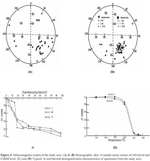
The specimen remnant vectors obtained after laboratory AF demagnetization have been averaged to obtain the sample mean ChRM vectors using Fisher's (1953) method. Sample mean ChRM improved as result of demagnetization by removal of viscous magnetization acquired by these rocks with the precision parameter (K) increasing from 4.64 to 25.74. The mean ChRM vector for all the specimens together is Dm = 148.1 and Im = + 43.5 (K = 25.74, α95 = 5.88) and are presented in Figure 4 B.
The ChRM vectors of samples from the two anomalous zones, the northern and southern zones in the vicinity of AA and BB are grouped separately and derived the mean remnant magnetic vectors from each anomalous zone. The northern zone showed a mean remnant magnetic direction of Dm = 138.1 and Im = + 42.24 (K = 29.21, a95 = 7.81) and the southern zone showed a mean remnant magnetic direction of Dm = 158.3 and Im = + 43.9 (K = 33.72, α95 = 7.27). Thus the NRM directions of both the zones are practically the same.
Discussion and conclusion
The inversion of observed magnetic anomaly suggests that two different bodies responsible for the anomalies are differently magnetized in direction, one practically horizontally and the other vertically. Since the palaeomagnetic directions of the rocks from the two anomalous zones are almost the same, and the surface rocks exhibit uniform susceptibility, the cause of the magnetic anomalies need to be expected to lie in the subsurface. In the peripheral areas of Deccan basalts there are reports of rude block formations in the basal flows, which in turn forming iron rich clay bodies due to weathering. (Foote, 1876). Therefore, the magnetic anomalies can be attributed to the two different iron rich clay bodies formed at the base of the flow I. These clay bodies might be acting as local barriers in the subsurface and may be obstructing the flow of ground water, resulting poor ground water conditions in the area down below the lake.
Acknowledgements
We thank the Director, National Geophysical Research Institute (NGRI), Hyderabad and Prof. I. V. Radhakrishna Murthy, Andhra University, Visa-khapatnam for their encouragement. We acknowledge the financial support by DST, New Delhi (16/165/2002).
References
Bhaskar, B. (1990) Geology in part of Nanded District of Maharashtra, Geological Survey of India Records, v.123, part 6, pp. 83-85. [ Links ]
CGWD Annual Action program report (1996), Groundwater resources & potential development of Nanded district, Maharashtra, Central Ground Water Department, Central Region, Govt. of India, Nagpur. [ Links ]
Fisher, R.A. (1953) Dispersion on a sphere, Proc. Roy. Soc. London, A 217, pp. 295-315. [ Links ]
Foote, R.B. (1876) The Deccan Trap and Associated Formations, Mem. Geol. Survey of India No.12, pp. 171-199., which reprinted in Geol. Survey of India Special Publication No.38., Annals of Deccan trap study and Bibliography on Deccan traps (1996) pp.43-65. [ Links ]
KumarD. andNaik, K..K. (1990) Geology in parts of Nanded district of Maharashtra, Geological Survey of India Records, v.123, part 6, Pub. By Govt. ofIndia, pp. 81-83. [ Links ]
Radhakrishna Murthy, I.V. (1998) Gravity and Magnetic interpretation in Exploration Geophysics, Memoir No.40, Geological Society of India, pp. 363. [ Links ]
Raychaudhuri, J.K., Saxena, N.P., Sinha, A.K. and Sen, D. (1984) Deccan trap flows in parts of Nanded and Yeotmal districts, Maharashtra, Geological survey of India special publication No.14,pp. 6-8. [ Links ]

