


Serviços Personalizados
Journal
Artigo
 Inglês (pdf)
 Artigo em XML
 Referências do artigo
 Enviar este artigo por email
Indicadores
-
 Citado por SciELO
 -
 Acessos
Links relacionados
-
 Citado por Google
 -
 Similares em
SciELO
Similares em
SciELO -
 Similares em Google
Compartilhar

 Permalink
Earth Sciences Research Journal
versão impressa ISSN 1794-6190
Earth Sci. Res. J. v.13 n.2 Bogotá jul./dez. 2009
GEOLOGY AND DEPOSITIONAL ENVIRONMENT OF CAMPANO-MAASTRICHTIAN SEDIMENTS IN THE ANAMBRA BASIN, SOUTHEASTERN NIGERIA: EVIDENCE FROM FIELD RELATIONSHIP AND SEDIMENTOLOGICAL STUDY
Adeigbe, O.C and Salufu, A. E
Corresponding address 1&2 Department of Geology, University of lbadan, Nigeria olukris2001@yahoo.com and seemeomoh@yahoo.com
Manuscript received: 11/08/2009 Accepted for publication: 18/12/2009
ABSTRACT
The study area lies within the Anambra Basin and it is made up of Enugu Shale, Mamu Formation, Ajali Sandstone, and Nsukka Formation. This study aimed at determining the geology and depositional environmental of these formations through field relationship and grain size distribution morphologic studies.
The field data shows Enugu Shale as fissile, light grey with extraformational clast which graded into Mamu Formation which is made up of shale, coal and sandy shale. It passes upward into Ajali Sandstone which is characterized by cross beds, Herringbone structures and Ophiomorpha burrows. The youngest formation within the basin is Nsukka Formation.
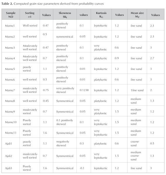
The granulometric study of Mamu Formation shows fine to medium grains, coarse, medium to fine grain for Mamu and Ajali Formation respectively. The standard deviation indicates poorly sorted. The kurtosis shows leptokurtic, platykurtic to very leptokurtic for both while the skewness values indicate positive and symmetrical in all except for Ajali Sandstone that is negatively skewed.
The bivariate and the multivariate results reveal shallow marine and fluvial deposits for both Mamu Formation and Ajali Sandstone respectively. The paleocurrent direction of Ajali Sandstone indicates southwest while the provenance is northeast.
The fissility of Enugu Shale suggests that it was deposited in low energy environment, distal to proximal lagoon environment. The presence of extraformatonal clast within Enugu Shale indicates fluvial incursion. However, the textural analysis of Mamu Formation suggests a sediment deposited in a low energy environment which favoured deposition of fine to medium size sediments that is, estuary environment. Textural result of Ajali Sandstone in the study area coupled with the field data such as Herring-bone structures, and Ophiomorpha burrows, revealed that Ajali Sandstone was deposited in a tidal environment probably littoral environment. While the light grey colour observed in the Nsukka Formation suggests sediments deposited under an oxidizing marine environment.
Key words: Anambra Basin, Geology, depositional environment, Mamu Formation and Ajali Sandstone
RESUMEN
El área de estudio está en la cuenca Anambra, compuesta de las Arcillas Enugu, la formación Mamu, la Arenisca Ajali, y la formación Nsukka. Este estudio ayudó a determinar la geología y el ambiente de deposición de estas formaciones mediante relaciones de campo y estudios morfológicos de distribución de tamaño de grano.
Los datos de campo muestran que las arcillas Enugu son quebradizas, de color gris claro con clastos extraformacionales que gradaron en la formación Mamu la que está compuesta de arcillas, carbón y arcilla arenosa. La Arenisca Ajali está caracterizada por estratificación cruzada, estructuras de espiga y túneles de Ophiomorphas. La formación más joven de la cuenca es la Formación Nsukka.
El estudio granulométrico de la Formación Mamumuestra tamaños de grano fino a medio, grueso, y de medio a fino para las Formaciones Mamu y Ajali respectivamente. La desviación estándar indica una pobre clasificación de los granos. La curtosis son leptocúrticas, platycurticas a muy leptocúrticas para ambas formaciones, mientras que los indicadores de asimetría muestran asimetría positiva y simétrica en todos los casos excepto para la Arenisca Ajali que presentó asimetría negativa.
Las distribuciones bivariadas y multivariadas indican depósitos someros marinos y fluviales para las Formaciónes Mamu y Arenisca Ajali respectivamente. La dirección de las paleocorrientes de la Arenisca Ajali es suroeste mientras que la procedencia es el noreste.
La fragilidad de las arcillas Enugu sugiere que fué depositada en un ambiente de baja energía, en ambiente de laguna distal a proximal. La presencia de clastos extraformacionales indica incursión fluvial. Sin embargo, el análisis de textura de la Formación Mamu sugiere que los sedimentos fueron depositados en un ambiente de baja energía la cual favoreció la depositación de sedimentos de tamaño finos a medio, esto es en ambiente de estuario. Los resultados de textura de la Arenisca Ajali en el área de estudio junto con los datos de campo tal como estructuras de espigaizarra laguna cercana y túneles de Ophiomorphas, revelaron que la Arenisca Ajali fué depositada en ambiente de marea probablemente ambiente de litoral. Mientras el color gris claro observado en la Formación Nsukka sugiere sedimentos depositados en un ambiente marino oxidante.
Palabras clave: Cuenca Anambra, Geología, Ambiente deposicional, Formación Mamu y Arenisca Ajali.
Introduction
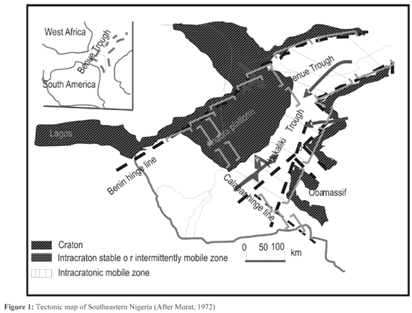
The tectonism in Southern Nigeria probably started in Early Cretaceous, with the separation of Africa from South American and opening of the Atlantic. This resulted in the development of the Benue Trough which stretched in a NE-SW direction (Fig. 1) and resting unconformably upon the Pre-Cambrian basement complex (Table 1). It extends from the Gulf of Guinea to the Chad Basinand is thoughtto have beenformed bythe Y-shaped (RRR) triple junction ridge system that initiated the breaking anddispersionofthe Afro-Brazilianplates inthe Early Cretaceous (Kogbe, 1989). After the evolution of the Benue Trough, sediments started depositing into the trough with Asu River Group being the oldest sediment followed by Ezeaku Group, and Awgu Group respectively (Nwajide, 1990).
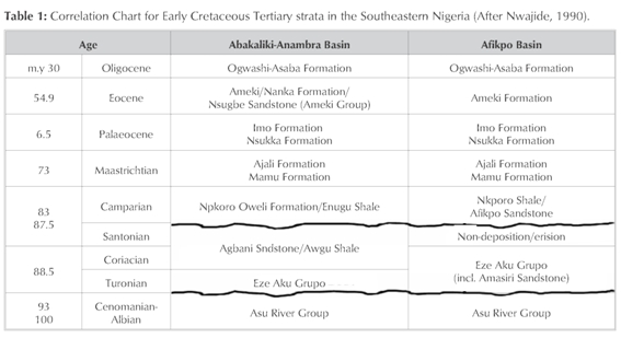
Santonian age marked the stage when the basin experienced another phase of tectonic event that involved deformation, folding, faulting andupliftofthe Pre-Santoniansediments leading to the formation of Anambra Basin which evolved as a depression to the west of the uplift (Benkhelil, 1987). Anambra Basin is a Cretaceous depo-centre that received Campanian to Tertiary sediments (Nwajide, 1990 and Obi, 2000). The stratigraphic setting of Southern Nigeria comprises sediments of three major sedimentary cycles. The first two cycles belong to the Pre-Santonian sediments while the third cycle belongs to Post-Santonian sediments which are found in the Anambra Basin and Afikpo Syncline (Nwajide, 1990).
In Anambra Basin, the strongly folded Albian-Coniacian succession (Pre-Santonian sediments) is overlain by nearly flat-lying Campanian-Eocene succession (Table 1). The oldest sediment in the Anambra Basin is Nkporo Group (Nwajide, 1990). It was deposited into the basin in Late Campanian, comprising Nkporo Shale, Owelli Sandstone and Enugu Shale (Reyment, 1965 and Obi, 2001).
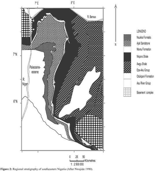
Nkporo Group is overlain by Mamu Formation (fig.2). It was deposited in Early Maastrichtian (Kogbe, 1989 and Obi, 2000). It comprises succession of siltstone, shale, coal seam and sandstone (Kogbe, 1989). Ajali sandstone (Maastrichtian) overlies Mamu Formation (Reyment, 1965 and Nwajide, 1990) which is mainly unconsolidated coarse-fine grained, poorly cemented; mudstone and siltstone (Kogbe, 1989). Ajali Sandstone is overlain by diachronous Nsukka Formation (Maastrichtian-Danian) which is also known as the Upper Coal Measure (Reyment, 1965 and Obi, 2000). Imo Shale (Paleocene) overlies Nsukka Formation (Nwajide, 1990). It comprises clayey shale with occasional ironstone and thin sandstone in which carbonized plants remains may occur (Kogbe, 1989). The Eocene stage was characterized by regressive phase that led to deposition ofAmeki Group (Obi, 2000).
Local stratigraphy description
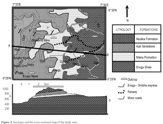
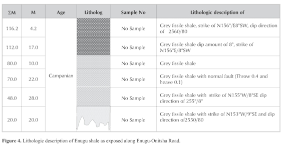
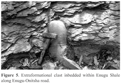
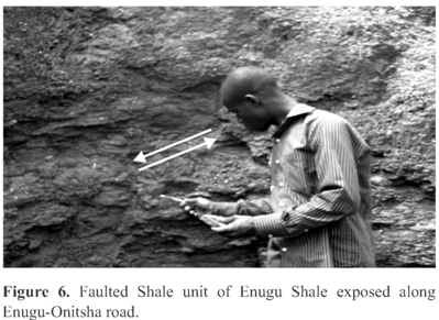
In the study area, Enugu Shale is the oldest formation and it is exposed in four different places; Location 1 (Enugu-Onitsha express road), Location 5 (River Ekulu), Location 6 and 7 (Ogbete) (Fig. 3). At the four locations, the outcrops have similar characteristics except for location 1 (Enugu -Onitsha express road) that has the widest exposure (both in vertical and lateral extents). The lateral extent is estimated to be over 1000m while the vertical extent is 116.2m (Fig.4). Along Enugu-Onitsha expess road (Location1] Enugu Shale has a basal bed It is dipping in the direction of 25578°, and trends in direction of S255°/8°SE. of grey fissile shale, estimated to be 20m thick (Fig.4). It is dipping in the direction of 255°/8°, and trends in direction of S255°/8°SE. The basal bed passes into another grey fissile shale unit of 28m thick, having similar altitude with the underlying bed. The section continued with 22m thick bed of grey fissile shale, characterized by extraformational clast (Fig. 5). This unit is overlain by a faulted (Fig. 6) fissile shale bed. The faulted bed is a normal fault with heave of 0.1m and throw of 0.4m. It is 10m thick, dipping in 245°/8° direction with strikes similar to the underlying bed. The faulted shale bed is overlain by grey shale of about 170m thick, having similar altitude with underlying bed. This section is terminated by 4.2m thick grey shale.
The Mamu Formation overlies Enugu shale. It is exposed at two locations; Location 2 (Onyeama coal mine) and Location 7 (Proda) of which Onyeama mine (Location 2) has the widest exposure. At the abandoned Onyeama coal mine in Enugu, the outcrop comprises succession of sandstone, siltstone, coal seam, heteroliths and shale, which has been grouped into three major facies as follows:
(i) Shale facies units.
(ii) Coal facies unit
(iii) Sandy shale facies unit
Shale Facies
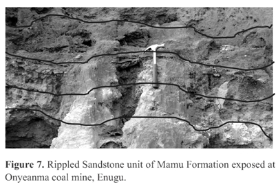
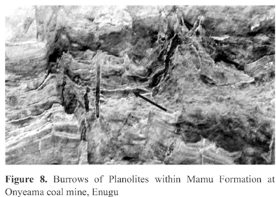
This facies is the oldest unit of the three, it commences with basal thin bed of light yellow, well laminated sandstone. The basal sandstone is overlain by dark grey horizontal fissile shale bed. The fissile shale graded into fine, well sorted, rippled (Fig. 7) light yellow sandstone. It transits into a dark-grey fissile shale bed that dips towards 260°/7° and strikes in N350°W/7°SE trend. It graded into light brown, bioturbated sandstone that has been reworked. It has traces of planolites burrows (Fig. 8). The sandstone bed is overlain by two thin beds of dark grey fissile shale. The last shale bed graded into 2.2m thick moderately consolidated white siltstone that is laminated with traces of plant roots.
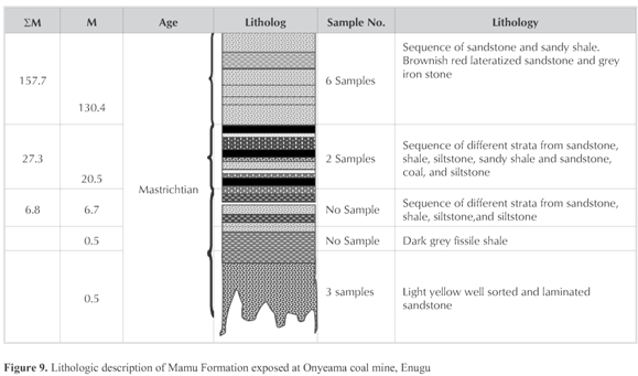
Coal Facies unit
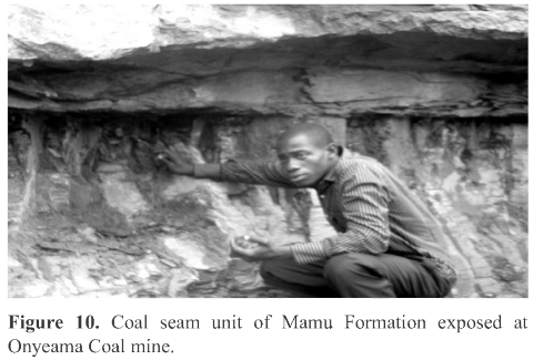
The coal facies unit is about 26m thick with alternation of coal seems, heterolith, sandstone and siltstone (Fig. 9). The basal bed of this facies is a coal seam of 0.1m thick. It passes unto heterolith which is overlain by white, moderately consolidated sandstone. The sandstone graded into a black coal seam. The facies continued upward with two whitish, laminated, rippled siltstone beds of 2m and 3m thick respectively. The siltstone makes erosional contact with the overlying medium-fine consolidated flat sandstone bed. The sandstone bed passes into heterolith which is then overlain by 0.2m black coal seam (Fig. 10) that terminates the coal facies unit.
Sandy Shale Facies Unit
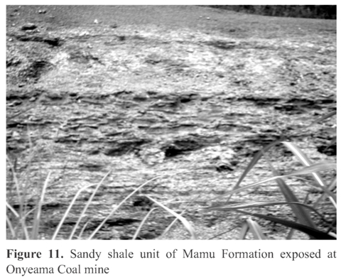
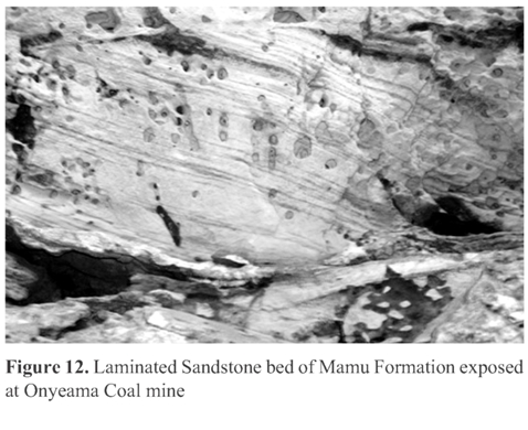
This unit is estimated to be over 130m. It is mainly of sandstone beds that are light yellow, well sorted-clayey, bioturbated, cross bedded with wave ripples. The sandy shale (Fig. 11) is overlain by 4.2m thick white laminated sandstone (Fig. 12).
Ajali Sandstone
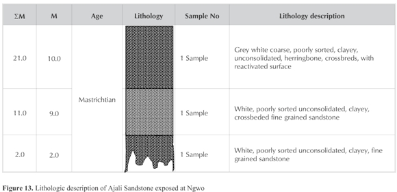
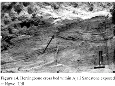
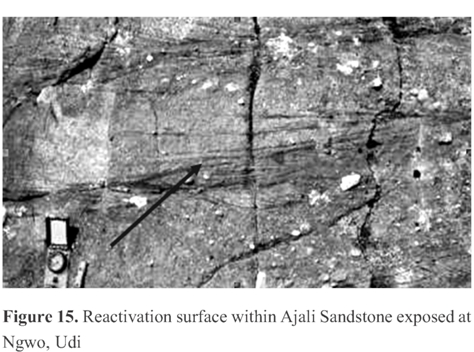
It is exposed at two stations in the study area; Location 3 (Ngwo) and Location 9 (9th Mile). The widest exposure of this formation is at Ngwo. The vertical exposure is estimated to be 21m while the lateral extent is estimated as 500m. The section starts with a basal, poorly sorted, poorly cemented unconsolidated white fine grained sandstone bed that is coarsening upward (Fig. 13).Ten meter (10m) thick, grey white poorly sorted, unconsolidated clayey sandstone bed that is characterized by herringbone cross beds (Fig. 14) and reactivation surface (Fig. 15) overlies the basal bed. This unit terminates the section with lateralized overburden.
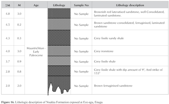
Nsukka Formation
It is exposed in one location within the study area, location 10. It is along Enugu- Eze-agu road. The vertical extent of the section is 4.8m while the lateral extent is 20m. Ferruginous brown, consolidated unit of 2m thick begins this section (Fig. 16). It graded into grey fissile shale. The shale unit trends S153°E/9°NW. It give effervescence in the presence of dil. HCL acid, thus indicating that it is carbonaceous. The fissile shale passes unto 0.9m thick grey fissile shale bed. The section continues upward to shaly sandstone bed overlying the shale. The lithology transits into a brown, consolidated, highly ferruginised sandstone overlying the sandy shale. The section gets terminated by 3m thick brownish red, well consolidated, laminated ferruginised sandstone bed. Nsukka Formation is the youngest formation in the study area.
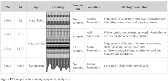
The composite log of the exposed formations in the study area is shown in Fig. 17. This revealed the field spatial relationship within the Anambra Basin, Southwestern, Nigeria.
Methodology
Fourteen representative samples of unconsolidated sandstones were collected from the study area. Eleven samples were collected from Mamu Formation at different horizons while three samples were collected from Ajali Sandstone (the unavailability of sandstones horizon/unit within Enugu Formation does not allow for grain size analysis). The samples were later disaggregated and divided into two equal parts of 50gm each. Sieving was done for each sample for 15 minutes on a Ro-tap sieve shaker, using a set of U.S standard sieve at % phi sieve interval.
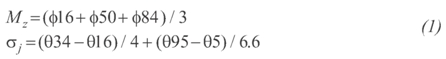
Cumulative curves of the grain size distribution were plotted from the sieve results. The univariate, bivariate, and multivariate parameters were computed from the sieve results after Folk and Ward (1970), Miola and Weiser (1977), and Sahu (1964). The formulae of mean size (Mz), standard deviation (oi),skewness (Ski) and kurtosis (Kg), used to compute the sandstones that underlie the study area are given below respectively.

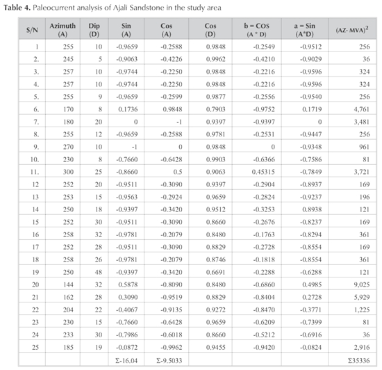
Multivariate parameter is computed for the sandstones in the study area by: Yu = 0.2852 MZ - 8.760451 - 4.8932ski + 0.0482KG. If the computed values of Yu > - 7.419, it is interpreted as shallow marine deposits while value of Yu < - 7.419 is interpreted as fluvial deposits (Sahu, 1964). The dip and azimuth of twenty five foreset of planner cross beds were measured from the cross bedded units of the Ajali Sandstone exposed in the study area. The measurement were carefully taken and recorded. The measurement were analyzed using variable constraints system by calculating the Mean Vector Azimuths (MVA) and variables of the cross bedded units of the Ajali Sandstone (Steinmetz,1962) in order to determine the paleocurrent of the Ajali Sandstone as well the trend of the paleocurrent by constructing rose diagram.
Results
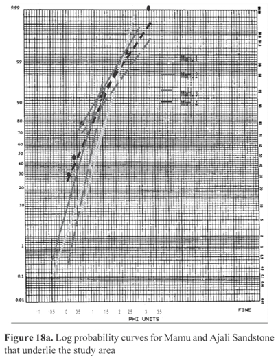
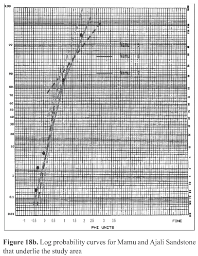
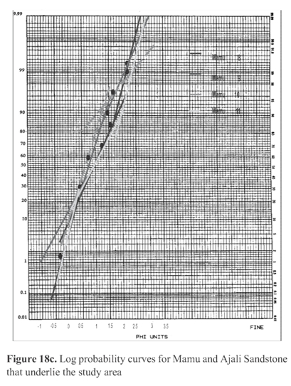
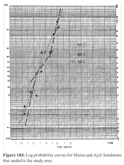
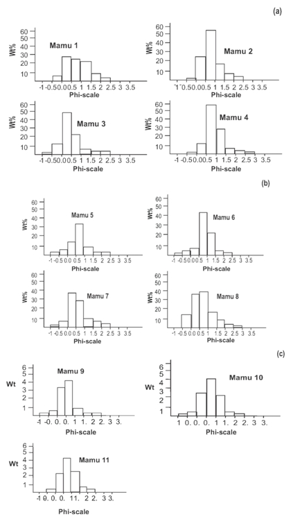
The probability curves for the samples of Mamu Formation and Ajali Sandstone show that the sandstone units of Mamu Formation were deposited by suspension and saltation (Fig. 18) while that of Ajali Sandstone were deposited by suspension, saltation, and traction (Fig. 18). The mean size result shows that the sandstone units of Mamu Formation are fine to medium (Table 2). The standard deviation result shows that the sandstone units of Mamu Formation are well sorted to moderately well sorted. The mean size result of Ajali Sandstone shows coarse, medium and fine sandstone. The standard deviation result reflects that the sandstone is poorly to moderately sorted (Table 2). The Histogram plots of the cumulative weight percent against the phi scale show that the Mamu Formation and Ajali Sandstone are unimodal (Fig. 19).
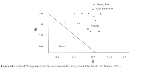
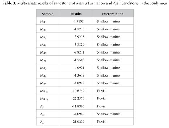
The results of bivariate plots for Mamu formation and Ajali Sandstone in the study area indicate beach and fluvial deposits (Fig. 20 and Fig. 21) while multivariate results indicate mainly shallow marine and fluvial deposits (Table 3).
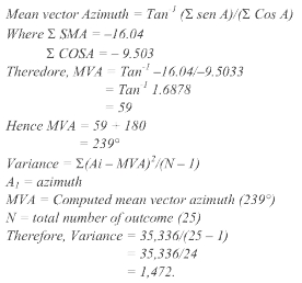
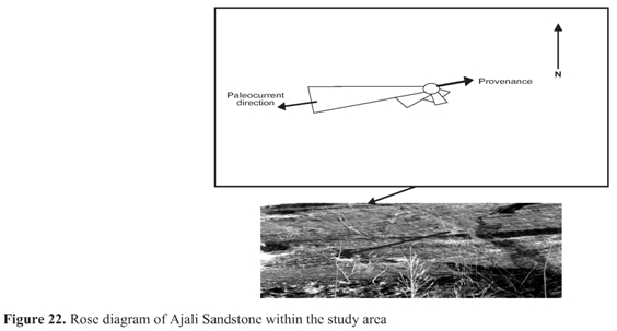
However, the result of the paleocurrent analysis of the foreset of cross bedded units is well pronounced in the Ajali Sandstone and less pronounced in the Mamu Formation (this may be due to the presence ofsiltstone, shale and coal in Mamu and complete absence in Ajali sandstone). This revealed that Ajali Sandstone has mean vector azimuth of 239°0 that is in direction of south west, and its variance is 1,472 (Table 4). However, the rose diagram indicates paleocurrent direction toward southwest while provenance is in direction of northwest (Fig. 22).
Discussion
Depositional environment
The fissility and the fine nature (Grain size) of the Enugu Shale as indicated by the field data suggest that Enugu Shale was deposited below the wave base, accumulated in relatively low energy environment i.e in a distal to proximal lagoon (Amaral and Pryor, 1974). The presence of extraformational clast within the Enugu Shale indicates that there was fluvial influence during the period ofdeposition of Enugu Shale within the Anambra Basin (Tucker, 1996). The light grey colour of the shale shows that Enugu Shale was deposited on the surface of the basin where oxidation could take place (Dapple, 1974).
The fine medium grained sandstone, siltstone and fissile shale and Planolites burrows that dominates Mamu Formation succession as observed from sieve and field relationships suggests that the unit was deposited in an environment where there was little or no existence of tidal or wave action i.e quiet environment where low energy favoured deposition of fine - medium size sediments. The presence of coal beds that alternate the shale, siltstone and sandstone units within Mamu Formation sequence indicates that Mamu Formation was deposited in estuary environment similar to the observation made by Reyment (1965) and Nwajide and Reijers (1996). The well sorted to moderately well sorted (Table 2) of Mamu Formation is an evidence of quiet environment with very low energy of deposition. The kurtosis for Mamu Formation revealed leptokurtic to platykurtic (Table 2) which suggest that Mamu Formation were sourced from more than one source which is similar to the observation made by Akaegbobi and Boboye (1999). The bivariate plots (Figs. 20 and 21) and multivariate (Tables 3 and 4) show that Mamu Formation was deposited in a shallow marine with prevalent of fluvial incursion.
Information from the field data shows that Ajali Sandstone is profusely cross bedded, characterized by Herringbone structures and Ophiomorpha burrows. The presence of these structures indicates tidal environment with high energy (Tucker, 1996). However, the presence of reactivation surface (Fig. 14) within Ajali Sandstone suggests fluvial action Reading, (1996) and Tucker, (1996). Thus, these field observations show that Ajali Sandstone was deposited under a tidal and fluvial channels interaction i.,e littoral environment. The sieve analysis shows that Ajali Sandstone is coarse, medium to fine grain poorly sorted sandstone (Table 2) which suggests fluctuation in energy of deposition. Also the coarsening upward nature of Ajali Sandstone as indicated by the univariate result (Table 2) suggests that the basin was shallowing upward (Dapple, 1974 and Tucker, 1996). This shallowing upward of the basin at the time of deposition of Ajali Sandstone into the Anambra Basin may be as a result of fluvial interference with the marine environment.
The paleocurrent analysis result shows that the variance value is 1,472. This value indicates that Ajali Sandstone was deposited in fluvial environment (Selley, 1966). The value of Mean Vector Azimuth (MVA) for Ajali Sandstone indicates 239° AZ (Table 4). This value and the rose diagram (Fig. 22) for Ajali Sandstone suggest that the direction of paleocurrent as at the time of deposition, acted in southwest direction and the provenance was northeast. The rose diagram reflects unimodal high variability paleocurrent pattern for Ajali Sandstone (Fig. 22). This paleocurrent pattern (Unimodal) suggests sediments deposited in an environment where fluvial currents was prevalent with net long-shore marine transport (Selly, 1966). The direction of provenance indicated that the sediments of Ajali Sandstone were sourced from the Basement Complex of Nigeria probably Obudu hill and or Cameroun Mountains in southeastern part of the country.
The presence of carbonaceous fissile shale within the Nsukka Formation as observed from the field data suggests that, it was deposited in shelf to shoreface environment (Akande and Mucke 1993, Obi, 2000). The light grey colour of the shale unit and the ferruginized nature of the sandstone unit of Nsukka Formation as observes from the field study, indicates that Nsukka Formation was deposited in an oxidizing environment where adequate oxygen was able to interact with the sediments, probably basin surface (Tucker, 1996).
Conclusion
The study of the ancient environment of the sediments of Anambra Basin has been reconstructed from the field relationships and textural analysis results. Before the Santonian tectonic event Anambra Basin was still in platform stage. However, sequel to Santonian tectonism, the study area opened up as Anambra Basin. Thus, the basin began to communicate with the Atlantic ocean. There was a rise in the sea level during the Campanian times and the sea transgressed into the land. The incursion of the Atlantic Ocean caused the basin to become deeper and quiescent. Thus, Enugu Shale was deposited into the basin. Gradually, the shoreline started withdrawing seaward from the land. Hence, the basin became starved of shale (Enugu Shale) as a result of the gradual increase in depositional energy within the basin. This resulted in the emergent of sediments deposited in a coastal environment of fluvial and marine water interaction.
Before the transgression of sea into the land, the land was already covered with giant plants and trees. When transgression phase set-in, those plants and trees were covered up with water and they began to decompose. Regression phase followed the transgression phase simultaneously and subsequently led to the withdrawal ofshoreline seaward such that sediments that were transported from the land were deposited and buried the decomposed plant and tree remains in the study area as Mamu Formation.Thus these plant remains were transformed into coal seams that exist in the Mamu Formation.
The shoreline continued to withdraw at a rapid rate such that the basin became shallow. As a result ofthis shal-lowness ofthe basin at this period paved wayto deposition of poorly sorted coarse sandstone into the basin in a littoral environment as Ajali Sandstone. Sedimentation of Ajali Sandstone in the basin lasted till Late Maastrichtian times when the shoreline began to move landward and the sea level began to rise. Thus, Nsukka Formation was deposited in an oxidizing shallow marine environment. Deposition of Nsukka Formation terminated sedimentation in the study area.
References
Akaegbobi I.M and Boboye O.A. (1999). Textural, Structural Features and Microfossil assemblage Relationship as a Delineating criteria for the Stratigraphic boundary between Mamu Formation and Nkporo Shale within the Anambra Basin, Nigeria. NAPE Bull, Vol. pp. 193-206. [ Links ]
Akande, S.O. and Mucke, A. (1993). Depositional Environment and Diagenesis of Carbonates at Mamu/Nkporo Formations, Anambra Basin, Southern Nigeria. Journal of African Earth Sciences, vol. 17, pp. 445-456. [ Links ]
Amaral, E.J. and Pryor, W.A. (1974). Depositional Environment ofSt. Petters Sandstone deduce byTextual Analysis. Journal Sed. Petrol., Vol. 40, pp. 32-55. [ Links ]
Benkhelil, J. (1987). Cretaceous Deformation Magmatism and metamorphism in the Lower Benue Tough, Nigeria. Geol. Journ. Vol. 22, pp. 467-493. [ Links ]
Dapple, E.C. (1974). Sandstone types and their Associated Depositional Environments. Journal of Sedimentary Petrology. Vol. 4, pp. 695-707. [ Links ]
Folk, R.L. (1970). Petrology of Sedimentary Rocks. Hemphill, Austin, Texas 182p. [ Links ]
Folk, R.L. and Ward, W.C. (1957). A study in the significance of grain size parameter. Journal of Petrology. Vol. 37, pp. 327-354. [ Links ]
Friedman, G.M. (1961). Distribution between Dune, beach, and River sandstones, J. Sed. Pet., Vol. 37 pp. 327-354. [ Links ]
Kogbe, C.A. (1989). The Cretaceous and Paleogene Sediments of Southern Nigeria: In Kogbe C.a. (Ed.), Geology of Nigeria. Elizabethan Publ. Vo., Lagos, Nigeria. 273-286 pp. [ Links ]
Miola, R.J. and Weiser, D. (1977). Textural parameters: An Evaluation. Journal. Sed. Petrology. Vol. 38, pp. 45-53. [ Links ]
Murat, R.C. (1972). Stratigraph and Pale geography of Lower Tertiary, Southern Nigeria, in Dessavagie, T.P.J, and Whiteman (Eds.), Afri-geol. University of Ibadan, Nigeria. 425 p. [ Links ]
Nwajide, C.S. and Reijers, T.J.A. (1996). Geology of the Southern Anambra Basin. In: Reijers, T.J.A. (Ed), selected chapters on Geology, SPDC, Warri, pp. 133-148. [ Links ]
Nwajide, C.S. (1990). Cretaceous Sedimentation and Paleogeography of the Central Benue Though. In: Ofoegbu, C.O; (Ed.), The Benue. Tough structure and Evolution International Monograph Series, Braunschweig, pp. 19-38. [ Links ]
Obi, C.G. (2000). Depositional Model for the Campanian-Maastrichtian Succession, Anambra Basin, Southeastern Nigeria. Ph.D Thesis, University of Nigeria, Nsukka, Nigeria. [ Links ]
Reading, H.G. (1996). Sedimentary Environment Processes, Facies and Stratigraphy. Blackwell Scientific Publications, Oxford. 671. p. [ Links ]
Reyment, R.A. (1965). Aspect of the Geology of Nigeria. Ibadan University Press. 145p. [ Links ]
Sahu, R., (1964). Textual Parameters: An Evaluation ofFlu-vial and Shallow Marine Deposits. J Sed. Pet., Vol. 34, pp. 513-520. [ Links ]
Selley, R.C. (1966). Paleocurent and sediment Transport in near Shore Sediment of Sincte Basin. Libya. J. Geol. Vol. 75, No. 2, pp. 215-222. [ Links ]
Steinmetz, G. (1762). Paleocurrent and Provenance Determination of Sandstone Mustang Island, Texas, J. Sed. Petrol, vol. 30. pp. 753-780. [ Links ]
Tucker, M.E. (1996). Sedimentary Rocks in the Field. John Weley and Sons, Chichester, New York, 150 p. [ Links ]

