


Services on Demand
Journal
Article
 English (pdf)
 Article in xml format
 Article references
 Send this article by e-mail
Indicators
-
 Cited by SciELO
 -
 Access statistics
Related links
-
 Cited by Google
 -
 Similars in
SciELO
Similars in
SciELO -
 Similars in Google
Share

 Permalink
Earth Sciences Research Journal
Print version ISSN 1794-6190
Earth Sci. Res. J. vol.14 no.1 Bogotá Jan./June 2010
GROUNDWATER INVESTIGATION IN AWLAD SALAMEH, SOUTHERN SOHAG, UPPER EGYPT
Aiman Abdel Latif1 and Mohamed El Kashouty2
1 National Research Institute of Astronomy and Geophysics, Helwan
2 Cairo university, Faculty of Science, Geology Department aiman_aziz21@yahoo.com
Manuscript received: 22/12/2009 Accepted for publication: 16/05/2010
ABSTRACT
The groundwater was the only water resources in the reclaiming area in Awlad Salameh village in the western side of Nile valley in Sohag governorate, Egypt. The soil was salinized and decrease the income per capita due to the increase in water salinity. Fifty groundwater samples was analyzed for major ions, besides the hydrogeological data. The groundwater salinity increased in the northwestern, northern, and northeastern part, attributed to geological, hydrogeological, and anthropogenic sources. The structural pattern enhances the downward, lateral and upward intrusion of saline Eocene limestone and Nubian sandstone aquifers. The salinity decreased in areas of wadis deposits, which characterized by high infiltration of rainfall through gravelly and cobbly sediments. The K concentration is mainly caused by aquitard diffusion rather than anthropogenic. The saturation index approach and statistical analyses were determined and discussed with respect to the geomedia and anthropogenic source. The groundwater is unsuitable for drinking and irrigation purposes due to increase in total dissolved solids.
Key words: Awlad Salameh, groundwater, soil salinization, hydrogeochemical processes
RESUMEN
El agua subterránea es el único recurso de este tipo en el área de recuperación en el pueblo Awlad Salameh ubicado en el lado occidental del río Nilo en la provincia de Sohag, en Egipto. El suelo esta salinizado y disminuyó el ingreso per cápita debido al aumento de la salinidad del agua. Cincuenta muestras de aguas subterráneas fueron analizadas en busca de iones importantes, además de otros datos hidrogeológicos. La salinidad del agua subterránea aumentó en el noroeste, norte y noreste, debido a factores geológicos, hidrogeológicos y de fuentes antropogénicas. El patrón estructural realiza la intrusión hacia abajo, lateral y hacia arriba de la caliza salina del Eoceno y del acuífero de la arenisca de Nubia. La salinidad disminuyó en las zonas del depósito, que se caracterizan por la filtración de las precipitaciones a través de la grava y los sedimentos gruesos (adoquín). La concentración K es causada principalmente por difusión lenta en lugar de antropogénica. El índice de saturación y el análisis estadístico fueron determinados y discutidos con respecto a la Media y a la fuente antropogénica. El agua subterránea no es apta para beber ni para riego, debido al aumento del total de sólidos disueltos.
Palabras clave: Awlad Salameh, aguas subterráneas, salinización del suelo, procesos hidrogeoquímicos
1. Introduction
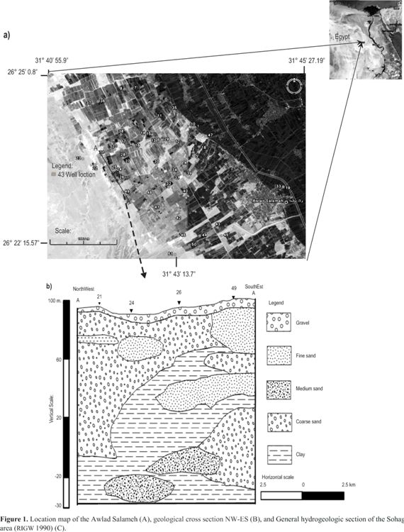
Sohag governorate constitutes an important hydrographic part in the Nile valley in Upper Egypt. Sohag governorate lies in the middle part of the Nile Valley which situated south of Cairo by about 460 km and has a total area of 11022 km2. Groundwater constitutes an important source of water in the strip of the desert fringes on both sides of the Nile Valley which has been partially reclaimed. Because of the development, the government and the people have been focused on the new areas in the western part of the cultivated land boundary (investigated area). The studied area occupies a region including both the floodplain and the desert fringes between longitudes 31o 30" and 31o 45"E and latitudes 26 o 15' and 26o 30"N (Fig. 1A). The Nile valley, in Sohag area, is bounded from east and west by the Eocene Limestone plateau. These plateaus are dissected by a number of drainage basins that drains towards the valley from the east and the west. The surface areas of these basins are around 740 km2. The strip of the desert fringes on both sides of the Nile Valley has been partially reclaimed and irrigated completely with groundwater. In the last ten years, rapid increase in the use of groundwater in the desert areas has occurred and that can affect the sustainability of the supply both quantitatively and qualitatively. Recent activities of the land reclamation are carried out in the area covering about 295 km2 where 182 Km2 could be reclaimed. The remaining area of about 263 km2 is not reclaimed yet. Sohag was represented by 5 % of Egypt (GASG 2004), the developments were relamation projects, new urban communities, industraial areas, and wastewater dis[osal sites in the desert zones of the Nile Valley. Untreated wastewaters dumped by industrial facuility impact the environmental helth (El Gohary et al 2002). Many problems in the production of crops and death of plants in the reclaiming area was found in Awlad Salameh, resulted from irrigation by saline groundwater. Groundwa-ter contamination is one of the principal environmental and public health problems in Sohag governorate. It is attributed to intensive use of agro-chemical fertilizers, septic tanks, and pesticides and wastewater disposal (Ayman 2009). Then, the main objective is to study the hydrogeochemical and hydrogeological characteristics of the shallow Quaternary aquifer. Fifty water samples were collected from the shallow (10-50 m water depth) Quaternary aquifer.
2. Geology and hydrogeology
The geology of the study area is very important especially in the hydrochemistry of groundwater, it is lightly influenced by the type of rocks, surficial soils, and structures in the area.
The study area was in the unstable shelf of Egypt (Meshref 1990). The structural features developed in the Nile Valley are Pre-Paleozoic or older basement trends and rejuvenated later on during Tertiary times (Sigaev, 1959; Said, 1961 and 1962; Brioussov, 1968; Yossef, 1968; Youssef etal. 1978). The Eocene plateau in Nile valley is effected by normal faults and drag folds (Yallouze and Knetsch, 1954; Abdel Kareem, 1972; Omaraetal. 1970 and 1973; Mustafa, 1979; Mahranand El Haddad, 1992). They stated that the structural features are originally induced from tensional rather than compressional forces. Structurally, the River Nile is drained in central part and bounded by two limestone plateaus on both sides. The River Nile is occupied on both sides by low lying areas (floodplain), represented by graben that created by upthrow of two plateaus. The latter gently dips about 3o due the central low part (Zaki 2001) and about 54 recorded surface fault planes.
The fault and interconnected of them influence greatly on the rate of precipitation-infiltration into the aquifer system and the enhance the upward leakage from the underlying aquifers (saline) toward the Pleistocene aquifer. Generally, the geology of Sohag area can be outlined as follows:
1) Thebes Formation (Eocene); it was first introduced by Said (1960) for the lower Eocene limestone of the Nile Valley. He described the Thebes Formation as massive to laminated limestone with flint bands or nodules and marl rich with Nummulites and planktonic foraminifera. Amer et al. (1970) and Said (1971), subdivided the Eocene rocks exposed between Luxor and Assiut into two formations, namely the Thebes Formation at the base and the Manfalut Formation at the top. The Thebes Formation includes the massive to laminated limestone with flint bands and concretions. The exposed part of the formation decreases gradually toward the north due to the regional gentle sloping northward.
2) Muneiha Formation (Pliocene); Issawi et al. (1978) mentioned that Muneiha Formation includes the estuarine fine clastic sediments accumulated due to the invasion of the Mediterranean Sea which create a long gulf from Cairo to Aswan in Pliocene time, these sediments are equivalent to the Madmoud Formation (Said 1981). Omer 1996 divided this formation into two main divisions (lower and upper members) according to the facies and the depositional environment.
3) Issawia Formation (Pliocene/Pleistocene); Said (1981 and 1990) mentioned that, by the end of the Pliocene and beginning of the Pleistocene, arid climatic conditions prevailed over Egypt causing the cessation ofthe riverine activities. This left local depressions, which received water only during seasonal rainy storms; lacustrine sediments were accordingly accumulated within these depressions. These lacustrine sediments were treated as the Issawia Formation (Issawi, et al. 1978 and Omer, 1996). Sediments of the Issawia Formation include two interfingered facies: the carbonate facies and clastic facies.
4) The Pleistocene sands; they consist of a thick succession of the Pleistocene sand-gravel association, which is widely distributed along the Nile valley in both the surface and subsurface. These sediments have been studied by many authors (e.g. Wendorf and Said, 1967, Said, 1975, 1981; Paulissen and Vermeersch, 1987; Issawi and McCauley, 1992; Omer, 1996; Omer and Issawi, 1998).
5) Dandara Formation; During the Late Middle Pleistocene, the Ethiopian water coupled with the dry phase in Egypt resulted into an exotic suspended-load river depending mostly on the seasonal rainfall in Ethiopia (Said 1975, Omer, 1996, Omer and Issawi, 1998). Sediments accumulated during this stage (Dandara Formation) were thus entirely derived from the upper reaches of the Nile in Ethiopia and southern Sudan. These sediments are formed mainly of fluviatile fine sand-silt intercalation and accumulated at low-energy environment.
6) Recent Wadi Deposits; Generally, the intermittent activities of the transverse channels led to the accumulation of flashflood deposits covering the surface of the older sediments throughout the desert areas outside the cultivated land.
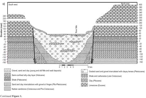
These deposits vary greatly in both the thickness and texture depending upon the land morphology and the intensity and regime of the flashflood rainfall. They range in thickness from few centimeters to more than 30 meters. They are formed of the disintegrated product of the nearby Eocene carbonates, in addition to the reworked material from the pre-existing sediments. The aquifer is semi confined around the River Nile, shifted to uncon-fined away from the floodplain (Fig. 1B).
The investigated aquifer is the Pleistocene that overlies the fissured Eocene limestone, the Holocene silt and clay act as capping bed (Fig. 1C). The Pleistocene aquifer thickness is 260 m around the River Nile and vanished due the two plateaus. The aquifer mainly was recharged from the irrigation and draining canals and the rainfall. Groundwater flow generally at Sohag Governorate is towards the River Nile. The highest contour lines are at the valley fringes 65 m (masl) and lowest contour are close to the River Nile 53 m (masl). The groundwater is recharging the River Nile which acting as a natural drain (Ahmed 2007a). The horizontal and vertical hydraulic conductivity of the capping sediments are 0.06 and 0.0086 m/d, the specific storage coefficient is 7.6 *10-6 (Abdel Moneim 1999). The Pleistocene aquifer horizontal hydraulic conductivity ranged from 40-100 m/d (Zaki 2001).
3. Materials and Methods
A total of 50 boreholes was collected from the Pleistocene aquifer and one sample from River Nile in Awlad Salameh village in Sohag Governorate. They were analyzed in the Centre of Reclaiming New Land in Ministry of Agriculture at January 2009. The location site is determined by GPS instrument. pH, EC, and temperature are measured in situ using portable field kite. Cl, HCO3, Ca, and Mg were measured by titration, while SO4 is estimated by turbidity method, and Na and K were analyzed by flame photometer
4. Results and discussions
4.1 Water chemistry
The TDS concentration increased due the northwestern, northern, and northeastern part (Fig. 2a), attributed to high numbers of fault planes interconnected together to build a good conduits. These conduits facilitate the upward and downward leakage from the lower brackish (TDS 1000-5000 ppm) to saline ( TDS > 5000 ppm) aquifers and agricultural and sanitary wastewaters, respectively. The saline aquifers are Eocene limestone and Nubian sandstone, they non renewable and influenced by lithogenic.
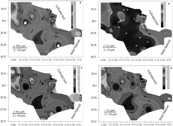
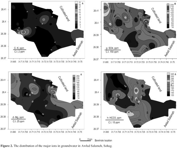
The Pleistocene aquifer is influenced by agricultural activities in old cultivated area and reclaimed lands and development projects in the desert zone (El Kola wastewater disposal in the eastern part and El Dair wastewater disposal site in the western part, Ayman 2009). The irrigation water is applied in flooding, which was at frequebcy oftwo and three times a month (Abdel Moneim 1992; Shamrukh et al. 2001). The pesticides detection in the Cow's milk confirm the agricultural impact (Dawood et al2004). The aquifer thickness increased due the northwestern part of the study area (Zaki 2001) to be increased the capacity of the received water from different sources through these fault planes. The TDS concentration decline in the southeastern, southwestern, and central-western part, caused by the presence of wadis deposits, which composed mainly of very gravelly and even cobbly (Fig. 1B) (Zaki 2001).
These wadis deposits drain in the Pleistocene aquifer and is characterized by high precipitation and infiltration rate (Zaki 2001). The wadi El Rashaydah drainage basin is the main wadi passing in the areas of low salinity. The basin length, streams orders numbers and lengths are 526, 2163, and 1132.94 km, respectively (Zaki 2001).
These data indicate elongation of the basin, which facilitate the passage ofrunoffand infiltrate downward to dilute the groundwater system. The drainage frequency is high and reflect a good collection of runoff (Zaki 2001). The thickness of the aquifer increased in the low saline groundwater areas mentioned previously. It can dilute the groundwater through the rainfall infiltration into the low water saline areas. Na concentration resemble the TDS trend (Fig. 2b). The K concentration anomaly shifted from the TDS trend to be in the central-western part (Fig. 2c), because of aquitard diffusion intercalated and tapped the aquifer. The Mg, Ca, Cl, and SO4 concentrations are similar to the TDS trend (Fig. 2d, e, f, and g). The Ca and SO4 concentrations are mainly attributed to the agricultural wastewater especially fertilizers. The HCO3 concentration increased in the low saline groundwater areas (Fig. 2h), confirm the dilution from the surface meteoric water (rainfall) into the aquifer system. The pH values is very limited (8.1 -8.5) by the continuous leakage from the rainfall.
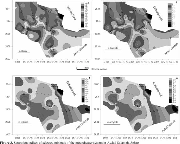
4.2 Saturation index approach
The calcite and dolomite are super saturated in groundwater (Fig. 3a & b), they increase in saturation in the northeast and northwest directions. The southwestern, southeastern, and central map parts are the lowest saturation indices with respect to calcite and dolomite. Only the southwestern part match with low TDS concentration, while the southeastern and central map parts coincide with high TDS concentration. It reflect the Ca and Mg concentrations partially contributed by anthropogenic and lithogenic sources. The groundwater is under saturated with respect to gypsum and anhydrite (Fig. 3c & d), they decrease in saturation due the southwestern part, by dilution from the rainfall infiltrated through the wadis deposits.
4.3 Statistical analyses
TDS is strongly correlated with Na, Mg, Ca, Cl, and SO4, reflect the dissolution of limestone, evaporation, and anthropogenic source (agricultural wastewater). The K concentration is not included in the groundwater salinity correlation, indicate that it is contributed by the aquitard diffusion from the Pliocene clay and the clay interbedded with sand and gravel of Pleistocene aquifer (Moukana and Koike 2008). Ca is strongly correlated with Mg reflect a common mineralogic sources, may be weathering of amounts of cal-cite and dolomite (Stauffer and Wittchen 1991). The principle component analysis (PCA) Shine et al., 1995; Ruiz, 2001; Lui et al., 2003 and Zhou et al., 2004) have been using SPSS program (Statistical Program of Social Science) under windows version 12.0 (statistical program) in order to study the interrelationship among the chemical elements in the groundwater. Two factors were identified, factor 1 positively loaded with TDS, Na, Mg, Ca, Cl, SO4, and more or less HCO3.
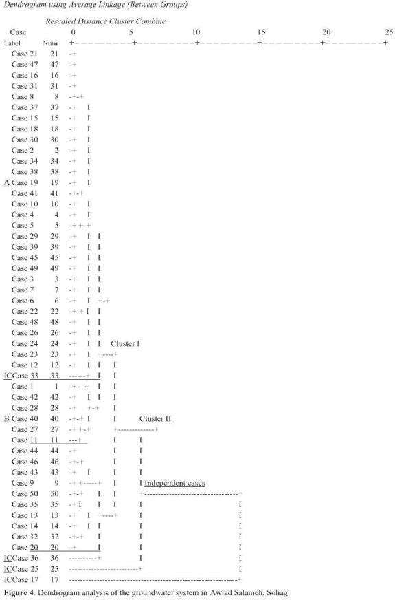
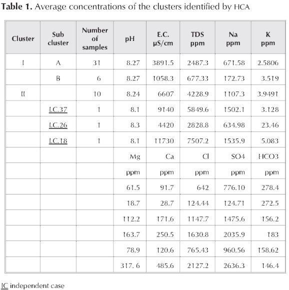
It reflect the groundwater system was contributed by evaporation, recharge, anthropogenic, and dissolution of geomedoia. The 2nd factor loaded with pH and K, clarify the aquitard diffusion that depend upon the pH condition. The dendrogram investigation revealed two clusters and three independent cases (Fig. 4), based on hydrogeochemistry of the groundwater. Cluster I was subdivided into two sub cluster A and B. Sub cluster A include 31 samples and has average concentrations as shown in Table 1. It is distributed allover the study area, caused by lithogenic and anthropogenic sources and also recharge from freshwater. It contained the different groundwater salinity (moderate and high). Sub cluster B was represented by 6 samples, it is distributed due the central northwestern part. It is characterized by the lowest TDS concentration, because of dilution from the infiltrated rainfall through wadis. Cluster II contain 10 samples, it is distributed in the northwestern and southeastern part. It is distinguished by higher salinity than the previous cluster, attributed to closer to the upward and lateral leakage of saline water from the Eocene limestone aquifer, therefore the groundwater salinity increased. The independent cases no. 18, 26, and 37 are located separately and have highest TDS , K, and Mg concentrations, respectively.
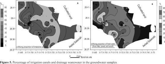
4.4 NetPath and AquaChem application
In Netpath program, mixing of two or more initial waters is modeled to show hydrogeochemical processes taking place due to mixing and migration of waters from two or more sources of recharging groundwater aquifer. The prevailing minerals in the formations, through which the migrating water passes and interacts, were used in the model. The initial waters are different, water from River Nile, canals, runoff, and limestone aquifer. Ground-and surface-water chemistry cannot be dealt with separately where surface and subsurface flow systems interact. The movement of water between two solutions provides major pathways for chemical transfer between terrestrial and aquatic systems. The limestone aquifer recharge rate increased in the northwestern, eastern, and northeastern part (Fig. 5a). The contribution by fresh water (River Nile, canals, and runoff) was increased in the southeastern and central-western part (Fig. 5b).
4.5 Water purposes.
The quality of groundwater is a function of physical, chemical, and biological parameters, so the standards should follow (WHO 1984, 1993, and 1997). Besides the anthropogenic sources, the geology also imposes its chemistry on the groundwater system. Drinking water standards are generally based upon two main criterion 1) objectionable taste, odor, and color; 2) presence ofsubstances with adverse physiological (health) effects. The suitability of groundwater for drinking and irrigation has been determined using World Health Organization (WHO) guidelines and United States Environmental protection Agency (USEPA 1976) and a modified Wilcox class model. Irrigation water quality is dependent on its specific conductance, relative proportion of Na to cations, plant types, soil, and climate. The TDS of groundwater samples exceeds the permissible upper limits (TDS = 1000 ppm) for drinking in the study area. The groundwater is high to very high salinity hazards. The water class was permissible to doubtful, which reduce the permeability and therefore decline the income per capita. The increase of total salinity in the irrigation water caused an excessive increase of its content in the soil. Consequently, an accumulation of salts in plant cells will cause the growth damage of such plants.
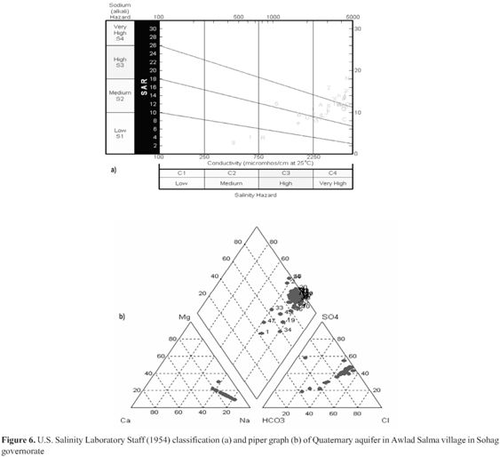
According to the U.S. Salinity Laboratory Staff (1954), the analyzed water samples are related to the following categories (Figure 6a); 1) medium salinity and low S.A.R. (C2-S1), it is used for irrigation for all crops; 2) high salinity and low S.A.R. (C3-S1), it apply in soil of medium texture; 3) highsalinity and medium S.A.R. (C3-S2), itis suitable for medium texture and high permeability; 4) high salinity and high S.A.R. (C3-S3), it is hazardous to most soils and requires good drainage and chemical amendments; 5) very high salinity and medium S.A.R. (C4-S2), it is not suitable due to its harmful water management for salinity control and leaching is necessary to remove the excess salts and is hazardous to most soils requires good drainage and chemical amendments; 6) very high salinity and high S.A.R. (C4-S3), it is not suitable due to its harmful water management for salinity control and leaching is necessary to remove the excess salts; 7) very high salinity and very high S.A.R. (C4-S4), it is not good for irrigation because its required chemical amendments and good drainage and most remove the excess salts. The samples numbers 13, 17, 20, 21, 24, 27, 38, 40, 41, 48, 49 and 50 are out of scale due to excessive salinity water, not advice to use for irrigation. Piper graphical representation indicate that almost all the samples fall in one zone (Fig. 6b) indicate a similar chemical signature. The cationic composition of the waters ranges from Na+K dominated through a mix of Mg+Na+K dominated. The anionic composition are chloride dominated. It is alkaline type with prevailing sulphate and chloride types.
Conclusion
This paper presents some of preliminary results of groundwater chemistry in Awlad Salameh village in Sohag Governorate, Upper Egypt. The problem of soil salinization was confirmed by this research. The ground-water salinity was very high in most of the samples. Caused by lithogenic and anthropogenic sources. The salinity decline where the infiltration enhanced in wadi deposits. The groundwater generally unsuitable for irrigation purpose and can cause soil salinization and water logging. The boreholes locations recommended in the areas of gravelly wadi deposits and after modeling of the aquifer system.
References
Abdel Kareem, H.H. 1972. Geology of the area west of the Nile Valley between Sohag and Girga. M.Sc. thesisi, fac of sci., geol Dept., Assiut Univ., 129p. [ Links ]
Abdel Moneim, A.A. 1992. Numerical simulation and groundwater management of the Sohag aquifer, The Nile Valley, Upper Egypt. PH.D. thesis, University of Strathclyde, Glasgow, Scotland, UK. [ Links ]
Abdel Moneim, A.A. 1999. Geoelectric and hydrogeological investigation of the groundwater resources on the area to the west of the cultivated land at Sohag, Nile valley, Upper Egypt. Geol Soc of Egypt. V 43/2, pp. 253-268. [ Links ]
Ahmed AA (2007a) Using lithologic modeling techniques for aquifer characterization and groundwater flow modeling of Sohag area, Egypt. Second International Conference on Geo-Resources in The Middle East and North Africa, 24-28 Feb, 2007, Cairo University, Egyp [ Links ]
Amer, A.F., Krintsov, M.L. and Hanna, F.L. 1970: The Egyptian carbonate rocks and the possibilities of their utilization. In: studies on some mineral deposits of Egypt. Geol. Surv. Egypt, p.195-208. [ Links ]
Ayman, A. 2009. Using generic and pesticides DRASTIC GIS-based models for vulnerability assessment of the Quaternary aquifer at Sohag, Egypt. Hydrogeology Journal, V17: 1203-1217. [ Links ]
Brioussov, B.A. 1968. Tectonic divisions and definition of basement relief in northern UAR according to gravity and magnetic data. The Geol Soc of Egypt. 6th Ann Meet pp. 12-14. [ Links ]
Dawood, A., Abdel El Maaboud, R., Helal, A., Mohamed, S., and Ali, W. 2004. Detection of organochlorine pesticides residues in samples of cow's milk collected for Sohag and Qena Governorates. Assiut University, Bull Environ Res 7: (2). [ Links ]
El Gohary, F., Wahaab, R., Nasr, F., and Ali, H. 2002. Three Egyptian industrial wastewater management programs. The Environ 22: 59-65. [ Links ]
GASG (General Authority of Sohag Governorate), 2004. Periodical Reports of Information Center. July, 2001, GASG Sohag. [ Links ]
Issawi, B. Hassan, M.W., and Osman, R. 1978: Geological studies in the area of Kom Ombo, Eastern Desert, Egypt. Ann. geol. survey, Egypt. V VIII, p.187-235. [ Links ]
Issawi, B., andMcCauley, J. F. 1992: The Cenozoic rivers of Egypt: the Nile problem. In: Freidman, R. And Adams, B., (Eds.), The Followers of Horus, Egypt: Studies Assoc. Public., no. 2, Oxbow Monog. 20, Park End Place, Oxford, p.121-138. [ Links ]
Liu WX, Li. XD, Shen ZG, Wang DC, Wai OW, and Y.S. Li. 2003. Multivariate statistical study of heavy metals enrichment in sediments of the Pearl river Estuary. Environ Pollut V121: 377-388. [ Links ]
Meshref, W.A. 1990. Tectonic framework in Said, R. (ed.), 1990 "The Geology of Egypt". A.A. Balekma, Rotrerdam, Brookfield, Ch. 8, pp. 113-155. [ Links ]
Mahran, T.M. and El Haddad, A. 1992. Facies and depositional environments of Upper Pliocene-Pleistocne Nile sediments around Soihag area, Nile Valley. J of Saharian Studies, V 1, no 2, pp. 11-40. [ Links ]
Moukanaa, J. and Koikeb, K. 2008. Geostatistical model for correlating declining groundwater levels with changes in land cover detected from analyses of satellite images. Computers & Geosciences 34, pp. 1527-1540. [ Links ]
Mustafa, H.A. 1979. Geological studies on the area northeast of Sohag. M. Sc. Theisi, thesis, Fac of Sci., Geol Dept., Assiut Univ., 259p. [ Links ]
Omara, S., El Tahlawi, M.R, and Hafez, H. 1970. The geology of the environs of Assiut Bull Soc Geograph, p. 43. [ Links ]
Omer, A. A. 1996. Geological, mineralogical and geochemi-cal studies on the Neogene and Quaternary Nile basin deposits, Qena-Assiut stretch, Egypt. Ph.D. thesis, Geology Dept. Faculty of Science, Sohag, South Valley University, 320 p. [ Links ]
Omer, A. A. and Issawi, B. 1998. Lithostratigraphical, mineralogical and geochemical studies on the Neogene and Quaternary Nile basin deposits, Qena-Assiut stretch, Egypt. The 4th International conference on Geology of the Arab World, Cairo. (Abstract). [ Links ]
Paulissen, M. and Vermeersch, P. M. 1987. Earth, man and climate in the Egyptian Nile Valley during the Pleistocene: In: A. Close (Ed.), Prehistory of North Africa. Southern Methodist University Press, Dallas, p. 29-67. [ Links ]
RIGW Research Institute of Groundwater (1990) Hydrogeological maps of Egypt, scale 1:100, 000. Water Research Center, Ministry of Public Works and Water Resources, Egypt [ Links ]
Ruiz, F. 2001. Trace metaks in estuarine sediments from the southeastern Spanish coast. Mar Pollut Bull 42 (6): 482-489. [ Links ]
Said, R. 1960. Planktonic foraminifera from the Thebes Formation, Luxor, Egypt. Micropaleontology, V16, pp. 227-286. [ Links ]
Said, R. 1961. Tectonic framework of Ehupy and its influence on distribution of foraminerfra. Amer Assoc Petrol Geol Bull, V45, pp. 198-218. [ Links ]
Said, R. 1962. The geology of Egypt. Elsevier Pub Comp. Amsterdam, NY, 377p. [ Links ]
Said, R. 1971. Explanatory notes to accompany the geological map of Egypt 1:2,000,000.Geol. Surv. Egypt. Paper 56,123p. [ Links ]
Said, R. 1975. The Geological evolution of the River Nile. In: Problems in Prehistory of Northern Africa and the Levant. Wendorf, F. and Maks, A.F. (Eds.). Southern Methodist University Press. Dallas, Texas, p.1-44. [ Links ]
Said, R. 1981. The geological evaluation of the River Nile. Springer-Verlage, New York 151p. [ Links ]
Said, R. 1990: The Geology of Egypt. S.A., Balkema, Rotterdam, Brookfield, 731p. [ Links ]
Shamrukh, M., Corapcioglu, M., and Hassona, F. (2001). Modeling the effect of chemical fertilizer on groundwater quality in the Nile Valley aquifer, Egypt. Groundwater 39 (1):59-67. [ Links ]
Sigaev, N.A. 1959. The main tectonic features of Egypt, An explanatory note to the tectonic map of Egypt. Scale 1:2000000 Geological Survey (Cairo); paper no. 39, 26p. [ Links ]
Shine, J.P., Ika, R.V., and Ford, T.E. 1995. Multivariate statistical examination of spatial and temporal patterns of heavy metals contamination in New Bedford Harbour marine sediments. Environ Sci.technol 29: 1781-1788. [ Links ]
Stauffer, R. and Wittchen, B. 1991. Effects of silicate weathering on water chemistry in Forested, upland, felsic terrane of the USA: Geolchimica et Cosmochimica Acta, V55, p. 3253-3271. [ Links ]
US salinity laboratory Staff, 1954. Diagnosis and improvement of saline and alkali soils, US Dept. Agr. Handbook. V6, Washington DC, pp.1-60. [ Links ]
US Environmental Protection Agency, 1976. National interim primary drinking water regulations; EPA-570/76/003; Washinton, DC, USEPA Office of water supply. [ Links ]
World health Organization (WHO), 1984. International standards for drinking water, 3rd Edition, V1, Geneva. [ Links ]
WHO, 1993. Guidelines for drinking water quality, World Health Organization. [ Links ]
WHO, 1997. Guidelines for drinking water quality, World Health Organization. 2nd edn., V1; Recommendations. [ Links ]
Wendorf, F., and Said, R. 1967. Paleolithic remains in Upper Egypt. Nature, v.215, p.244-247. [ Links ]
Yallouze, M., and Knetsch, G. 1954. Linear structures around the Niule basins (comprehensive analysis oftec-tonic evolution in north Africa). Bull Soc Geograph , Egypt. V22, pp. 154-207. [ Links ]
Youssef, M.I. 1968). Structural pattern of Egypt and its interpretation. Amer Assoc Petrol Geol Bull, V52, pp. 601-614. [ Links ]
Youssef, M.M., Riad, S., and Mansour, H.H. 1978. Surface and subsurface structural study of the area arounfd Assiut, Egypt. Bull Fac Sci Assiut Univ., V6, no 2, pp. 293-306. [ Links ]
Zaki, S., 2001. Hydrogeological studies and application of GIS for evaluation of water resources and land use projects in the southern pasrt of Sohag govornorate. M.Sc. thesisi, fac of sci., geol Dept., MenoufiaUniv., 179p. [ Links ]
Zhou, H.Y., Peng X. T., and J.M. Pan. 2004. Distribution, source, and enrichment on some Chemical elements in sediments of the Pearl River Estuary. China Continental Shelf Res, 24: 857-1875. [ Links ]

