


Services on Demand
Journal
Article
 English (pdf)
 Article in xml format
 Article references
 Send this article by e-mail
Indicators
-
 Cited by SciELO
 -
 Access statistics
Related links
-
 Cited by Google
 -
 Similars in
SciELO
Similars in
SciELO -
 Similars in Google
Share

 Permalink
Earth Sciences Research Journal
Print version ISSN 1794-6190
Earth Sci. Res. J. vol.14 no.1 Bogotá Jan./June 2010
SEISMIC GEOHISTORY AND DIFFERENTIAL INTERFORMATIONAL VELOCITY ANALYSIS IN THE ANAMBRA BASIN, NIGERIA
Ekine, A.S.1 and Onuoha, K. M.2
1 Department of Pure and Applied Physics, University of Port Harcourt, Port Harcourt
2 Department of Geology, University of Nigeria, Nsukka, Nigeria asekine2001@yahoo.co.uk
Manuscript received: 17/12/2009 Accepted for publication: 15/05/2010
ABSTRACT
The methods of seismic geohistory analysis and differential interformational velocity analysis have been applied using data from some interpreted seismic sections within the Anambra basin. These two techniques for basin analysis have been applied in the basin in an attempt to aid the identification of anomalous velocity zones. Results from the seismic geohistory analysis indicate that some faults arising probably from compressional stresses, due to the upliftment of the Abakaliki anticlinorium, were observed to be significant mostly in the northern and southeastern regions of the basin. These faults which originated in the Santonian are probably related to the first folding episode in the evolution of the Benue Trough. The Maestrichtian / Campanian faults observed towards the north of Anambra River-3 well may also have been influenced by these stresses or are directly related to the Post-Maestrichtian folding episode in the Benue Trough. The fault system KP identified on the seismic section is a Pre-Eocene event which cuts across from the south of Okpo-1 andNzam-1 to the north of well. Sediments to the north of Nzam-1 well site have experienced more faulting during the Lower-Maestrichtian times. Fault systems that occurred after the Paleocene times are more prominent in the southern parts of Nzam-1 towards well sites. Generally most of the major faults occurred in the Paleocene. The major 'DIVA' anomaly observed southeast of Anambra River-1 well correlates with the zone of overpressures within which liquid hydrocarbon, water and gas have been discovered in the basin. The Maestrichtian to Paleocene sediments in the southern and mainly in the southwestern sector of the Anambra basin should be the major sedimentary strata with liquid hydrocarbon potentials, whereas the Lower Cretaceous and particularly the Santonian sediments exhibit the highest potentials for gaseous hydrocarbons.
Key words: seismic geohistory; seismic section; differential velocity; Anambra basin.
RESUMEN
Los métodos de Análisis Sísmicos histórico y análisis de velocidad interformacional diferencial se han aplicado usando datos de algunas secciones sísmicas interpretadas de la cuenca Anambra. Estas técnicas se han aplicado en un intento de ayudar a la identificación de zonas de velocidad anómalas. Los resultados del Análisis Sísmico histórico indican que algunas fallas probablemente surgen de esfuerzos de compresión, debido a la elevación del Anticlinorio Abakaliki, importantes sobre todo en las regiones norte y el sureste de la cuenca. Estas fallas que tuvieron su origen en el Santoniano, están probablemente relacionados con el primer episodio de plegamiento en la evolución de la depresión de Benue. Las fallas maestrichtiense / Campaniano observadas hacia el norte del pozo Anambra River -3, también pueden haber sido influenciadas por estos esfuerzos o están directamente relacionados con el episodio de plegamiento post-maestrichtiano de la depresión de Benue. El sistema de fallas KP identificado en la sección sísmica es un evento pre-Eoceno que atraviesa desde el sur de Okpo-1 y Nzam 1-al norte del pozo Iji-1. Los sedimentos al norte de la ubicacióndel pozo Nzam-1 hanexperimentado mayorfallamiento enel maestrichtiano temprano. El sistema de fallas producido después del Paleoceno es más prominente en las partes meridionales desde Nzam-1 hacia el pozo Iji-1. En general la mayoría de las principales fallas se produjeron en el Paleoceno. La gran anomalía 'DIVA' observada al sudeste del pozo Anambra River -1 se correlaciona bien con la zona de sobrepresiones en la que hidrocarburos líquidos, agua y gas han sido descubiertos. Los sedimentos que van del maestrichtiano al Paleoceno en el sur y principalmente en el sector suroccidental de la cuenca Anambra deberían ser los principales estratos sedimentarios con potencial de hidrocarburos líquidos, mientras que los del Cretácico Inferior y en particular los sedimentos Santonianos exhiben el más alto potencial de hidrocarburos gaseosos.
Palabras clave: Geohistoria sísmica, sección sísmica; velocidad diferencial; cuenca Anambra.
Introduction
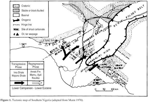
The Anambra Basin has been identified as one of the major in-land sedimentary basins in Nigeria. It is bounded on the east by the Abakaliki anticlinorium and on a south-westerly direction by the Benin hinge-line, while the southern extreme is marked by the upper limits of the Eocene growth faults of the Niger Delta (Merki, 1972). The basin is about 300 km long in a northeast - southwest direction, extending between the Onitsha environs in Anambra State to the Loko area in Benue State ofNigeria. Its southwestern tip is about 160 km wide, while the northeastern extreme is about 48 km wide (Whiteman, 1982) (Fig. 1).
The geologic history ofthe basinhas beenthat ofnearly continuous subsidence and sedimentation, and had therefore remained largely unaffected by major tectonism. The stratigraphic successions in the Anambra Basin and environs have been discussed by several authors which include (Reyment, 1965; Murat, 1972; Adeleye, 1975; Peters, 1978; Whiteman, 1982; Hoque and Nwajide, 1984; Agagu et al, 1985).
The reconstruction and the analysis of the geologic history of a sedimentary basin are very significant for the analysis of the subsidence and thermal histories of such a basin. This method of reconstruction or geohistory analysis has been applied by many authors using stratigraphic and other geophysical data (Angevine and Turcotte, 1981; Middleton, 1982; Onuoha, 1985; Onuoha and Ekine, 1999; Ekine and Onuoha, 2008). However, in recent times, geohistory analysis has been successfully applied to seismic data (Middleton and Falvey, 1983; Middleton, 1984). Seismic geohistory analysis is a technique whereby the geologic history of a sedimentary basin is reconstructed in terms of two-way travel times from observed seismic reflection data. This method provides a means of rapidly reconstructing the geologic history from an interpreted seismic section.
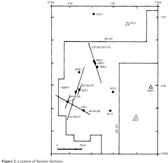
Again in recent times, the great advances in exploration tools, techniques and experiences have compelled and motivated many explorationists to shift their exploration emphasis from the quest for simple structural to stratigraphic traps. The difference between structural and stratigraphic traps can either be quite clear or so subtle for differentiation where both traps play significant roles as trapping mechanisms. The use of seismic techniques for the identification and definition of stratigraphically trapped hydrocarbons has been made possible by the introduction of sophisticated packages and approaches in seismic data interpretation. The differential interformational velocity analysis, originated by Neidel and Beard (1984), attempts to delineate anomalous low velocity zones by tracking laterally the interval velocity (stacking velocity) along a seismic profile by using the travel times for the reflectors that have been identified. These two techniques for basin analysis have been applied in the Anambra basin using some interpreted seismic sections (see Fig. 2). This attempt is to aid in the identification of anomalous velocity zones which in normal circumstances could be attributed to the occurrence of reefs, sand bars, geomorphic features and other features commonly associated with stratigraphic traps. Also the study will demonstrate the applicability of these non conventional techniques in the search for the subtle traps.
Methodology
P-waves travelling through sedimentary layers are found to obey a power law equation given by Acheson (1981) as

where t = the one-way travel time; z = depth to reflector; a, b and n = constants.
Consequently, the two-way travel time T can be expressed as

According to Falvey and Middleton (1981), and Middleton, (1984), the behaviour of porosity φz with depth z can be sufficiently approximated by the expression
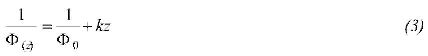
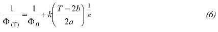
where φ0 = the depositional porosity and k = a constant. The above expression has been used in this study as the main thrust of the study is not the evaluation of reservoirs as in Ehrenberg etal., (2009).
To decompact and reconstruct the geologic history ofa sedimentary basin from interpreted seismic section, a procedure similar to burial history reconstruction is applied. In this case depths are replaced with arrival times. According to Sclater and Christie (1980), the height of sediment grain hsg for a unit cross-sectional area between the intervals z1 and z2 is given by the expression
where z'1 and z'2 are the depths to the top sedimentary units when z1 = z'1 is at the surface.
Substituting equation (2) into equation (3) gives
and equation 5(b) now becomes
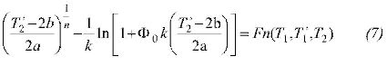
with
T'1and T2 are the reflector times when T1 =T'1 is at the surface.
(T'2 ,T1 and z'2 have been defined in the equations as required)
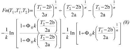
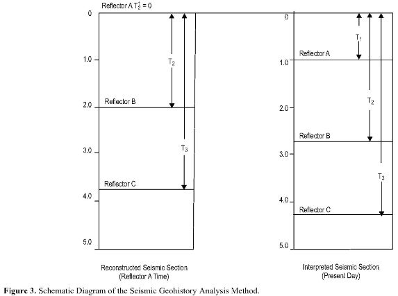
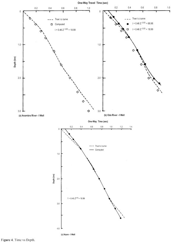
Equation (8) is the basis for the seismic geohistory analysis. This equation is solved numerically for T2', with T1' = 0 at the surface for the first instance. Fig. 3 is a schematic representation of the process of seismic history analysis. For subsequent reflectors and cycles a similar procedure as employed for the burial history reconstruction was used in this study (Ekine and Onuoha, 2008). Using the two-way travel time versus depth plots obtained at Anambra River-1, Oda River-1 and Nzam-1 well sites (Figs. 4a, b, and c), a time-depth relation was obtained for the basin.
This relation can be expressed as

where t is in milliseconds and z is in feet.
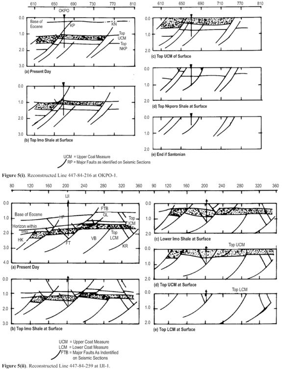
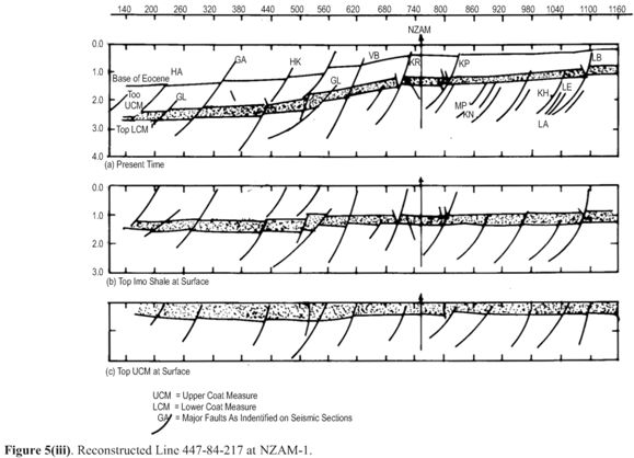
Seismic geohistory analysis was carried out along three interpreted seismic sections which were calibrated at Iji-1, Nzam-1 and Okpo-1 wells. The generalized porosity-depth relations were obtained from each well along individual seismic line and not a generalized relation for the whole basin. This approach significantly reduced the possible errors associated with simple assumed basinal generalized functions and thus enhances the representativeness of the porosity-depth and the time-depth functions. The reconstructed seismic sections as obtained from the solutions of equation (7) are shown on Figs. 5(i), (ii) and (iii).
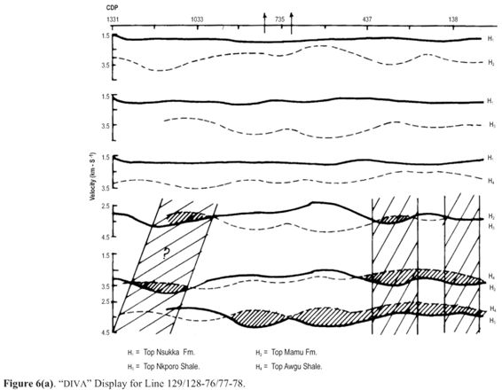
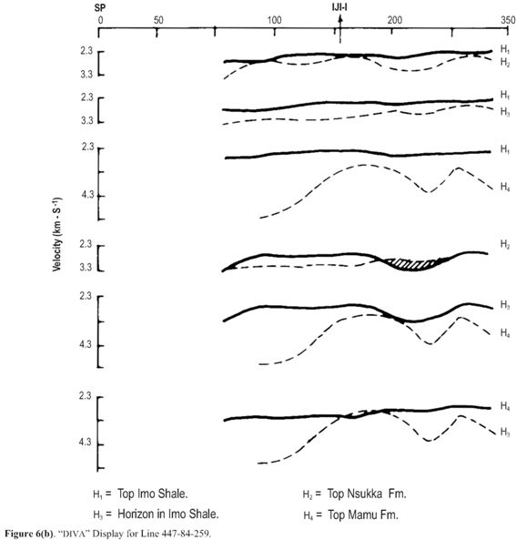
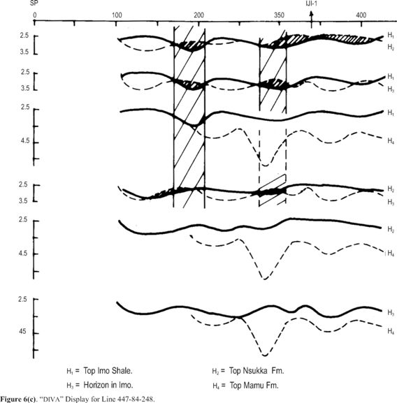
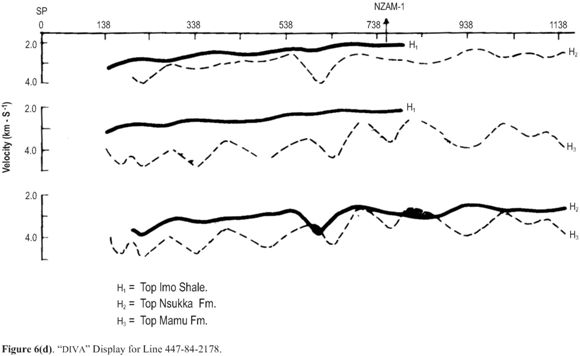
Finally, the method of differential interformational velocity analysis (DIVA) was applied to some interpreted seismic section within the basin. These velocity sections include those calibrated at Anambra River-1, Anambra River-3, and Nzam-1 wells. The graphics of the analysis are displayed on Figs. 6a, b, c and d.
Discussions
The results of seismic geohistory analysis carried out along three interpreted seismic sections indicate that most of the major faults in the basin originated in the Post-Maestrichtian times and mainly in the Paleocene. The observed major faults are found to commence mainly within the Nkporo shales at Okpo-1 well site (Fig. 5(i) (d, e)); within the Lower Coal Measure at (Fig. 5(ii)(d, e)) andNzam-1 (5(iii)(c)) well sites. These formations were deposited in the Post-Maestrichtian times. This observation correlates with the renewed high rate of subsidence and sedimentation revealed by the reconstructed burial analysis (Ekine and Onuoha, 2008). A very good correlation also exist between sediments depths obtained from the decompaction method and that obtained from seismic geohistory analysis by converting travel-times to depths using the time-depth relation obtained for the basin. Similarly, some faults arising probably from compressional stresses, due to the upliftment of the Abakaliki anticlinorium (Ekine, 1989) were observed to be significant mostly in the northern and southeastern regions of the basin. These faults which originated in the Santonian are probably related to the first folding episode in the evolution of the Benue Trough. The Maestrichtian / Campanian faults observed towards the north of Anambra River-3 well may also have been influenced by these stresses or are directly related to the Post-Maestrichtian folding episode in the Benue Trough. The fault system KP identified on the interpreted seismic section [see Figs. 5(i)(b) and 5(iii)(b)], is a Pre-Eocene event which cuts across from the south of Okpo-1 andNzam-1 to the north of well. It is observed that sediments to the north of Nzam-1 well site have experienced more faulting during the Lower-Maestrichtian times. However, fault systems that occurred after the Paleocene times are more prominent in the southern parts of Nzam-1 towards well sites. Generally, we observed that most of the major faults occurred in the Paleocene. Some other faultings which occurred in the Santonian were mainly significant in the northern and the southeastern parts, whereas the Post-Eocene faults were predominantly in the southwestern portions of the basin.
The differential interformational velocity analysis, 'DIVA', carried out along four seismic sections indicated mainly minor 'DIVA' anomalies. However, the 'DIVA' display for line 129/128 - 76/77 - 78, calibrated at Anambra Rivers-1 and -3 wells, show major anomaly beyond CDP 437 and to the end of the seismic line southeast of Anambra River-1 [see Fig. 6(a)]. This anomaly is within the tops of Mamu Formation and the Agwu Shales. A similar anomaly, not clearly defined, is indicated northwest of Anambra River-3 well. This anomaly is within the same levels with beds dipping southwest, or shows the trend of migrating fluids and hydrocarbons. The top of Agwu Shales contains the column of water and liquid hydrocarbons observed at the Anambra River-1 well. The major 'DIVA' anomaly observed southeast of Anambra River-1 well correlates with the zone of overpressures within which liquid hydrocarbon, water and gas have been discovered in the basin. The absence of any other well defined anomaly along this section implies that the overpressured condition and the hydrocarbon deposit do not extend in that direction or that the section analyzed is not long enough to clearly show this trend.
Conclusions
The method of seismic geohistory analysis has shown that the timing of faulting in a basin is very important for the understanding of the problem of hydrocarbon migration and accumulation. The lack of adequate stratigraphic or structural trappings may lead to vertical or lateral migration of liquid hydrocarbon and their possible dissemination. When the time of hydrocarbon maturation (Ekine, 1989), is related to the timing of the observed fault systems, the absence of accumulated liquid hydrocarbons in the north-central parts of the Anambra basin can be explained.
Results of the differential interformational velocity analysis have further confirmed the existence of velocity anomalies resulting from changes in rock type and or fluid content, which substantially enhances the magnitude of the anomaly when the presence of gas is indicated. The DIVA results indicate that the Maestrichtian to Paleocene sediments in the southern and mainly in the southwestern sector of the Anambra basin should be the major sedimentary strata with liquid hydrocarbon potentials, whereas the Lower Cretaceous and particularly the Santonian sediments exhibit the highest potentials for gaseous hydrocarbons. The above geophysical tools employed in this study for basin analysis, have demonstrated their effectiveness for obtaining information about the tectonism, hydrodynamics, hydrocarbon and geothermal resource potentials of basin. Consequently, we suggest that the methods of seismic geohistory analysis and DIVA be further pursued using high fidelity seismic sections with greater coverage.
References
Acheson, C. H., 1981. Time-depth and velocity-depth relations in sedimentary basins: A study based on current investigations in the Arctic Islands and an interpretation of experience elsewhere. Geophysics, 46: 707 - 716. [ Links ]
Adeleye, D. R., 1975. Nigerian late Cretaceous stratigraphy andpaleogeography. A. A. P. G. Bull., 59: 2302-2313. [ Links ]
Agagu, O. K., E. A. Fayose and S. W. Peters, 1985. Stratigraphy and sedimentation in the Senonian Anambra basin of Eastern Nigeria. Nig. Journ. Min. Geol., 22: 25 - 36. [ Links ]
Angevine, C. L. and D. L. Turcotte, 1981. Thermal subsidence and compaction in sedimentary basins: Application to Baltimore Canyon trough. A. A. P. G. Bull., 65: 219 - 225. [ Links ]
Ehrenberg, S. N., P. H. Nadeau and 0. Steen, 2009. Petroleum reservoir porosity versus depth: Influence of geological age. A. A. P. G. Bull., 93(# 10): 1281 - 1296. [ Links ]
Ekine, A. S., 1989. Empirical heat flow studies, geohistory analysis and hydrocarbon maturation modelling in the Anambra Basin, Nigeria. Unpublished Ph. D. thesis, University of Nigeria, Nsukka. [ Links ]
Ekine, A. S. and K. M. Onuoha, 2008. Burial history analysis and subsidence in the Anambra basin, Nigeria. Nig. Journ. Phys., 20 (#1): 145 - 154. [ Links ]
Falvey, D. A. and M. F. Middleton, 1981. Passive continental margins: Evidence for break-up deep crustal meta-morphic subsidence mechanism. Oceanologica Acta, suppl., 103-110. [ Links ]
Hoque, M. and C. S. Nwajide, 1984. Tectono-sedimentological evolution of an elongate intracratonic basin (Aulacogen): The case of the Benue Trough of Nigeria. Nig. Journ. Min. Geol., 21: 19-26. [ Links ]
Merki, P., 1972. Structural geology of the Cenozoic Niger delta. In African Geology, ed. T. J. F. Dessauvigie and A. J. Whiteman. University of Ibadan Press, pp. 251 - 268. [ Links ]
Middleton, M. F., 1982. The subsidence and thermal history of the Bass basin, Southeastern Australia. Tectonophysics, 87: 383 - 397. [ Links ]
Middleton, M. F. and Falvey, D. A. 1983. Maturation modelling in Otway Basin, Australia. A. A. P. G. Bull., 67(#2): 271 -274. [ Links ]
Middleton, M. F., 1984. Seismic geohistory analysis - A case history from the Canning Basin, Western Australia. Geophysics, 49: 333 - 343. [ Links ]
Murat, R. C, 1972. Stratigraphy and paleogeography of the Cretaceous and Lower Tertiary in Southern Nigeria. In African Geology. ed. T. J. F. Dessauvigie and A. J. Whiteman, University of Ibadan Press, pp. 635 - 648. [ Links ]
Neidel, N. S., and J. H. Beard, 1984. Progress in strati-graphic seismic exploration and the definition of reservoirs. Distinguished Author Series, Journ. Pet. Tech. pp. 709 - 726. [ Links ]
Onuoha, K. M., 1985. Basin subsidence, sediment decompaction and burial history modelling techniques: Applicability to the Anambra basin. N. A. P. E. Proc., 2: 6 - 17. [ Links ]
Onuoha, K. M. and A. S. Ekine, 1999. Subsurface temperature variations and heat flow in the Anambra basin, Nigeria. Journ. African Earth Sc., 28(#3): 641 - 652. [ Links ]
Peters, S. W., 1978. Stratigraphic evolution of the Benue Trough and its implication for the Upper Cretaceous paleogeography of West Africa. Journ. Geol., 86; 311 - 322. [ Links ]
Reyment, R. A., 1965. Aspects of the geology of Nigeria: The stratigraphy of the Cretaceous and Cenozoic deposits. University of Ibadan Press. [ Links ]
Sclater, J. G. and P. A. F. Christie, 1980. Continental stretching: An explanation of the Post-Mid-Cretaceous subsidence of the Central North Sea basin. Journ. Geophysical Research, 85: 3711 - 3739. [ Links ]
Whiteman, A. J., 1982. Nigeria: Its petroleum geology, resources and potential. Vols. I and II, Graham and Trotham, London. [ Links ]

