


Serviços Personalizados
Journal
Artigo
 Inglês (pdf)
 Artigo em XML
 Referências do artigo
 Enviar este artigo por email
Indicadores
-
 Citado por SciELO
 -
 Acessos
Links relacionados
-
 Citado por Google
 -
 Similares em
SciELO
Similares em
SciELO -
 Similares em Google
Compartilhar

 Permalink
Earth Sciences Research Journal
versão impressa ISSN 1794-6190
Earth Sci. Res. J. v.14 n.2 Bogotá jul./dez. 2010
Potential littoral sediment transport along the coast of South Eastern Coast of India
S. Saravanan and N. Chandrasekar
Centre for GeoTechnology Manonmaniam Sundaranar University Tirunelveli - 627 012, TamilNadu, India. E-mail: geosaravanan2000@yahoo.co.in
Record
Manuscript received: 05-07-2010 Accepted for publication: 30-11-2010
ABSTRACT
In the nearshore zone ofpresent study area, the movement ofsand alongshore is due to the action ofwaves and currents. The sediment movement along the shoreline ofstudy area is mainly governed by the forces associated with the incoming wavesandtheavailabilityofsedimentswithinthearea. Thepresentinvestigationhasbeenmadeasanattempttoappreciate the sediment movement in relation to wave activity along the coast. The longshore sediment transport is higher in the northerly direction as compared to southerly direction. The normal condition is for and to be moved annually or more frequently in the shallows and on the beach. Waves and wave-driven currents cause longshore drift ofsand alongthe beach and offshore. The net erosive nature of the study area (except Kanyakumari) from March to October is due to the prevalence ofhigh waves from S and SE directions.
Keywords: Beach, Sediment, Littoral sediment transport, India.
RESUMEN
En la zona próxima a la costa del área de estudio, el movimiento de la arena a lo largo de la costa es debido a la acción de las olas y las corrientes. El movimiento del sedimento a lo largo de la línea de costa del área de estudio es principalmente gobernado por fuerzas asociadas a las olas entrantes a la costa y la disponibilidad de sedimentos en la zona. Esta investigación fue realizada para estudiar el movimiento del sedimento en relación a la actividad de las olas a lo largo de la costa. La dirección del transporte de sedimento a lo largo de la costa es mayor hacia el Norte que hacia el Sur. Las condiciones normales para el movimiento anual del sedimento se encuentran en aguas someras y en la playa. Las olas y la corriente de oleaje generan una deriva litoral de las arenas a lo largo de la playa y costa afuera. La erosión natural en el área de estudio (exepto Kanyakumari) entre Marzo y Octubre es debido a la prevalencia del gran oleaje desde la dirección Sur y Sureste. Introduction
Palabras clave: Playa, sedimento, transporte sedimento litoral, India.
Introduction
The knowledge about sediment movement, on a long-term basis, in the nearshore environment is a pre-requisite for the design of shore protection structures and for navigational purposes. It is understood that this movement of sediment, particularly in the surf zone, is governed by complex interplay of waves and the nature of prevailing sediments in addition to morphology of beaches. Broadly, the alongshore component ofwave energy together with the intense turbulence associated with breaking waves determine the sediment motion quantitatively.
Investigations on sediment drift based on empirical relationship developed from quantitative estimates of littoral flows through wave refraction studies and field and laboratory experiments on the nature of movement of sediment in the vicinity of natural barriers have been made along various coastlines of the world (Inman et.al.,1969; Komar and Inman, 1970; Walton and Chiu,1979). Along the coastline of India such quantitative determinations have been reported at different localities (Prasannakumar, 1985; Reddy et.al., 1984; Sarma and Reddy, 1988; Rajamanickam et.al., 1986; Chandramohan, 1988, Chandrasekar, 1992; Chandramohan and Nayak, 1991; Angusamy, et.al., 1998; Sanjeev et.al., 1997; Bodapathi, 2000; Sanil Kumar et.al., 2000, Chandrasekar et.al., 2001). The sediment movement along the shoreline of study area is mainly governed by the forces associated with the incoming waves and the availability of sediments within the area. The present investigation has been made as an attempt to appreciate the sediment movement in relation to wave activity and beach morphodynamics along the coast.
Sharaf andMahar (1997) have examined the sediment transport along the Nile delta coast Egypt. The budget of the transported sediments along the Nile delta coast show that, the area between Abu Quir and Rashid and that between Ras El Bar and Portsaid are characterised by accretion while those between Rashid and Burullas and between Burullus and Ras El Bar are characterised by erosion. Ciavola et.al., (1997) have carried out field measurements of long shore sand transport and control processes on a steep mesotidal beach in Portugal. They have concluded that improvement should be needed in the understanding of the sedimentary behaviour of steep reflective beaches, where, because of the short surf zone, wave energy dissipation takes place over small distances, leading to relatively high alongshore sediment transport rates. Wang et.al., (1998) have evaluated the total long shore sediment transport rate in the surf zone by using field measurements and empirical predictions. Giosan et.al., (1999) have discussed in detail about the long shore sediment transport pattern along the Romanian Danube Delta coast. They have pointed out that net long shore sediment transport is controlled by the offshore bathymetry and by obstacles, which obstruct that surfzone along the coast.
In the Indian coast, various investigations pertaining to different aspects of oceanographic and morphological features have been carried out by a number of researchers. Veerayya and Pankajakshan (1988) have reported long shore sediment transport pattern along the Manglore coast. Chandramohan (1988) have discussed and estimated the rate of longshore sediment transport along the Indian coast. Jena (1997) has reported the littoral drift sources and sinks along the Indian coast. Hanamgond (1993) have explained about the sediment movement on Aligadde beach, Uttara Kannada West coast of India and stated that the beach morphology undergoes cyclic seasonal changes in response to the changing wing and wave climate. Sanil Kumar et.al., (2000) have studied the long shore currents and beach morphodynamics along Kannirajapuram coast, Tamilnadu. Chandramohan and Nayak (1991) have accounted the wave induced longshore sediment transport at different places along Indian coast.
Study Area
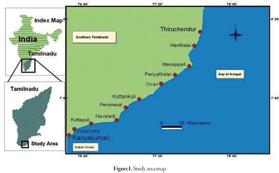
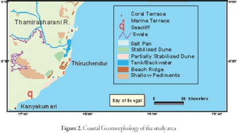
The study area is located along the southern coast of Tamilnadu State, India (Fig. 1). It extends over a distance of32.78 Km and the southeast coastline borders the Bay of Bengal. The backshore of the beach is limited by urban infrastructures. The Mean Sea Level (MSL) is 2m above the 0m depth chart datum (CD). The local mean tidal range is 0.5m and the maximum tidal level above CD is 1m. The net longshore transport is directed to the north. The drainage pattern along the study area is controlled by minor streams like Palaiyar, Namiyar, Hanuman Nadhi and seasonal streams like Nilapparai channel and Puttanar channel (Fig. 2). Cliffs are along the Kanyakumari coast which projects towards the Indian Ocean forming a promontory. Coastal areas of Rasthakadu and Kuttapuli have sandy beaches and some areas are rocky in nature. Sand mining is also actively pursued along the coast.
Saravanan et.al (2009) and Chandrasekar et.al (2006) are evaluated the post-tsunami assessment and Classification of Tsunami Hazard along the Southern coast of India. Angusamy (1998) made a panoramic classification of the beaches between Mandapam and Kanyakumari, TamilNadu based upon the beach composition, beach gradient and beach configuration. Moni (1972); Prasannakumar and Murthy (1987) Chandramohan and Nayak (1991); Rajamanickam et. al., (1986) Veerayya and Pankajashan (1988) and Gujar (1996) have indicated from their studies along west coast of India that the predominant direction of waves in the area are from SW, WSW, W and WNW with periods ranging from 6 to 12 seconds. Anbarasu (1994); Chandrasekar (1992); Angusamy et.al., (1998), Chandrasekar et. al., (2001) have discussed about the wave refraction pattern and its role in the redistribution of sediments along the east coast of India. Saravanan and Chandrasekar (2010a,b) have analysed the monthly and seasonal variation of beach and the distribution of various assemblage of heavy mineral present along the south eastern cost ofIndia.
Shoreline Configuration
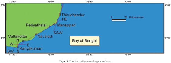
In the study region, shoreline configuration is appeared to have been controlled and influenced by the predominant monsoonal wind directions of both NE and SW. Waves and longshore currents have also played an important role for shaping the shoreline. The shoreline of the study region displays a varying trend inE-W, N-S, NE-SWand NNE - SSW directions (Fig. 3).
NE-SWDirection
This part of the coast is higher than that of any other areas in Gulf of Mannar with undulating sand hills and the hinterland mostly of reddish soil. In due south, from Periyathalai to Vatakkottai the NE - SW trend is represented by minor zigzag patterns at few places.
N-S Direction
The other direction ofconfiguration is in N-S direction from Vembar -Tuticorin. Otherwise the N-S configuration is seen in the study area as a very narrow strip to fill up the gap developed between the two different configurations of NNE - SSW and NE - SW in places like Kanyakumari, Tuticorin and Navaladi.
NNE-SSWDirection
The next prominent configuration is from Tuticorin - Manappad in the directionofNNE - SSW. TherivermouthofThamirabharaniisindentedwith numerous creeks with a chain of backwaters running parallel to the coast. Thiruchendur is a low rocky headland projecting into the sea where, well developed marine terraces are exposed.
NE- SWDirection
From Vattakkottai - Kanyakumari, once again the coastal configuration reverts back to EW direction and finally enjoins with west coast by showing a trend of N-S direction for a smaller distance. Various natural processes are foundto prevailinthecoastalsegmentbetweenVattakottaiandKanyakumari.
In short, major part of the study area is aligned in the direction of NE-SW. It is worth to note that economically viable heavy minerals are found to get segregated only in this configuration.
Waves, Currents and Tides
As the waves, currents and tides contribute significantly in the redistribution of the sediments, supplied to the depositional basin, the rate of these oceanographic physical agents is discussed with sediment distribution and littoral transport in the study area. Waves are found to provide necessary energy for the movement of water and sediments within the nearshore zone. They govern the evolution of beaches that act as buffer zones for the impinging wave energy. The shape and size ofthese deposits, in turn, give rise to change in the incoming wave energy through changes in the nature of the wave breaking. When one considers the changes of this dynamic zone over a long time scale, the dominating effect of waves in deciding the orientation of this near elastic and energy absorbing zone becomes evident.
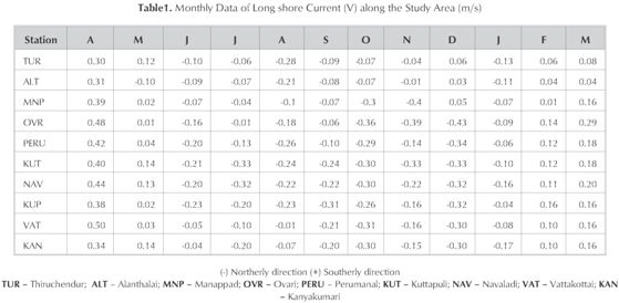
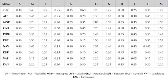
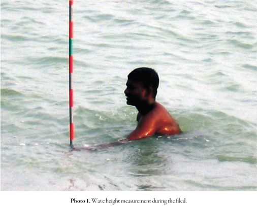
Currents are monsoonal in character. The currents are variable with respect to monsoonal climate. During SW monsoon (May - October) the currents are branching towards the NE from south easterlydirection that flows across the entrance of Gulf of Mannar. In NE monsoon (November to February), the flow is southward which implies mainly south westerly flow of currents across the Gulf of Mannar. The monthly variation of longshore currents is presented in the Table.1. It was less during the SW monsoon (June to October) and fair weather (March to May) conditions. Its direction is northerly during fair weather and SW monsoon seasons whereas towards southerly during NE monsoon period. Wind generated surface waves are the principal source of energy input into the littoral zone. They are responsible for the erosion of the coast and for the formation of depositional beach features. A notion on wave action is a fundamental mandatory to have an insight into the processes that takes place on beaches. In the present area ofinvestigation wave parameters are controlled by the change in monsoonal cycle. Waves approach the coast in SE, S and NE directions with wave period from 3 to 10 seconds (Bodapati, 2000). The breaking wave height observed in the study area varies from 0.05 to 0.85 m during SW monsoon period and that of 0.10 to 0.60 m duringNE monsoon period. The fair weather attests to the tune of 0.05 to 0.50 m of breaking wave height (Table. 2 & Photo.1).
At Kuttankuli, the breaker zone width ranges from 16 to 20 m with maximum duringJuly, October and November (20 m). Kanyakumari depicts a variation of the surf zone width from 15 to 20 m with highest during the months of February, May, November and December (20 m). At Vattakottai, the surf zone width shows a fluctuation from 15 to 20 m with a rise up to 20 m during May to July and October to December periods. At Thiruchendur, the surf zone width varies from 14to 18 mandwithamount during March and October. At Periyathalai, one may able to observe the variation of surf zone width from 14 to 20 m with a maximum during the months of January, April and August (20 m). Ovari attests a variation in surf zone width from 12 to 18 m with a highest during November (18 m). In the case of Kanyakumari, the surf zone width varies from 11 to 14 m with a peak during the months of June and September (14m).
Material Methods
The littoral zone is the most dynamic environment of the coast and one in which constant mobility of sediment is observed. The movement of material in this zone depends mainly on three factors: the nature of material available for transport (size and density), orientation and other features of the coast and the angle of wave approach (Swift, 1976; King, 1972). Littoral transport plays a major role in the development of certain shoreline features like spits and bars, and is causing considerable coastal erosion and accretion (King, 1974). The proper understanding of the monthly/seasonal littoral transport trend is important for the efficient coastal zone management and development.
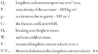
The longshore sediment transport rate is usually estimated based on empirical equation relating the longshore energy flux in the breaker zone to the longshore transport rate. Several discussions have already appeared on the selection of suitable equations for estimation of the longshore sediment transport (Graft and Overeem, 1979; Willis, 1980). Using the monthly average littoral environmental parameters collected at different locations of the study area, the longshore transport rates are estimated. The deepwater wave data for the study region is extracted from the wave atlas for the Indian coast published by National Institute of Oceanography, Goa (Chandramohan et.al., 1990). The following Walton and Bruno (1989) equation is used to estimate the longshore sediment transport rate.
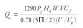
Where
The monthly longshore sediment transport rates estimated based on the monthly observations on breaking wave height (Photo.1), surf zone width and the longshore currents. The monthly volume of longshore sediment transport rates and directions are estimated for the coast at Kuttankuli, Vattakottai, Thiruchendur, Alanthalai, Manappad, Periyathalai, Ovari and Kanyakumari (Table 3).
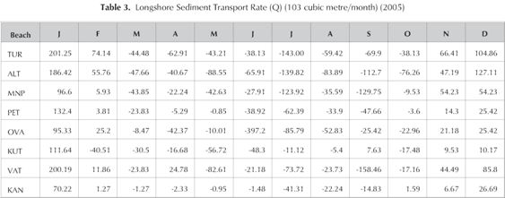
In general, the sediment transport is northerly during March to October and southerly during November to February. The longshore sediment transport is higher in the northerly direction as compared to southerly direction at all locations except Kanyakumari (Fig. 4). This occurs because the rocky outcrops shelter the Kanyakumari beach and manmade features such as harbour across the surf zone would act as a barrier and sand would be deposited on the updrift side of such barrier.

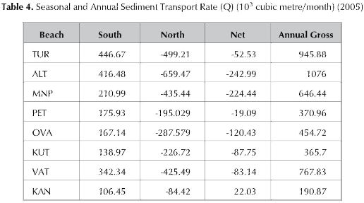
The littoral drift quantities are higher from May to October, due to heavy breakers associated with the SW monsoon season. The annual net sediment transport rate is northerly, Kuttankuli (87.75 x 10³m3/yr), Kanyakumari (194.1 x10³m3/yr), Vattakottai (83.14x 10³m3/yr),Thiruchendur (52.23x 10³m3/yr), Alanthalai (243 x 103m3/yr). At Kanyakumari, the annual net sediment transport rate is southerly, which is 22.03 x 10³m3/yr (Table.4). The quantity of littoral drift varies considerably from station to station, depending upon the wave and beach conditions. The maximum northerly annual net drift is observed at Alanthalai. This may be due to the complete exposure of the beaches to wave attack throughout the year. At Kanyakumari, a net southerly drift is perceptible. The net southerly drift estimated in the Kanyakumari location indicates that the growth ofshoreline near harbour takes place at the expense of the sediments eroded from those areas situated north of Kanyakumari. The material drifting towards the south from north is blockedat the harbour entrance and gets either deposited or transported to other reaches depending on the flow conditions. This depositional pattern has also been confirmed from the wave refraction analysis as well as littoral drift cell study.
The study indicates that in general, the entire stretch between Kanyakumari and Tiruchendur experiences a sediment transport rate of less than 1.1 x 10⁶m3/yr. The coast between Chennai and Paradeep experiences a gross sediment transport rate of more than 2 x 10⁶m3/year (Sundar and Sarma, 1992). Subsequently, Jena (1997) and Prabakar Rao (2002) have projected the gross sediment transport rate of southern Tamilnadu coast as 0.6 x 10⁶m3/yr and 0.7 x 10⁶m3/yr respectively. The increment in gross sediment transport is noticed during the present investigation as compared to earlier studies (Jena, 1997; Prabakar Rao, 2002). This is mainly due to the slight increase in the approaching wave angles to the coast during the study period. Again, the seasonal cyclonic depression and storm anomaly must have also contributed appreciably for the rise in sediment volume during the course of investigation.
Result and discussion
In the nearshore zone of present study area, the movement of sand alongshore is due to the action of waves and currents. The direction of littoral drift is from south to north during the period of March to October when the waves are between S and SE and from north to south during the period November to February when the wave directions are between E and ENE. The seasonal changes in the direction oflittoral drift with the SWand NE monsoons cause cyclic variations of the beach morphology along the coast under investigation. The rocky outcrops scattered across the littoral zone cause reversal of beach cycles at different stations along the coast. For example at Kanyakumari (October) during SW monsoon, the southerly movement of sediment is observed. The net littoral drift at all stations is generally from south to north with the exception of Kanyakumari station, where the net drift is southwards. This occurs because the northerly littoral drift during SW monsoon is very small (maximum of 41.31x 10³ m3/month), and a net annual southerly drift is recorded. The net erosive nature of the study area (except Kanyakumari) from March to October is due to the prevalence of high waves from S and SE directions.
The maximum net annual northerly drift is recorded at Alanthalai (243 x 103m3/year). This is mainly controlled by the offshore bathymetry and by the obstacles that impede the surf zone along the coast. Above all, overwash and onshore-offshore sediment transport are the possible mechanisms that control the drifting of sand. A complete study of wave dynamics is imperative at this instant which includes the measurement across the swash and surf zones of local sediment transport wave height, wave energy conditions, longshore current, grain size, etc., to comprehend and describe the swash processes precisely. Also the time scale of each study should be commensurate with that of the duration ofthe directional wave event that drives the transport. Further, emphasis has to be placed on formulating computer models to conjecture the performance of sediment movement for the development and management of coastal zone.
Conclusions
The east coast ofIndia experiences two phases ofstormyconditions during south-west and north-east monsoons, the south Tamilnadu coast ofthe ofIndia has comparatively less sediment transport due to the presence of shallow Palk bay, Gulf of Mannaar and the Sri-Lanka Island. They significantly control the longshore sediment transport along the south Tamilnadu coast particularly form Kanyakumari to Tiruchandur region. The reversal trend in the direction of sediment transport between Mandapam and Kanyakumari due to change in the coastal configuration, deposition and the formation ofnumerous spits along this coast. But the fluvial activities are negligible in the region. The formations of spits are prominent during the receding of south west monsoon. Moreover, the offshore islands present along this distinct coastal tract could protect the beach from the direct attack of waves, which in turn results low energy condition. The normal condition is for and to be moved annually or more frequently in the shallows and on the beach. Waves and wave-driven currents cause longshore drift ofsand along the beach and offshore.
A comprehensive study of major direct and theoretical measurement of longshore drift analysis using different beach parameters should have to be done. So, the study would be very helpful to investigate the littoral drift of sediments and beach morphological changes along the study area.
Acknowledgement
The authors are thankful to Dr. Bhoop Singh, Advisor, NRDMS, Department of Science and Technology, New Delhi and Department of Science and Technology, New Delhi for providing the financial assistance under NRDMS Scheme (ES/11/526/2000).
References
Anbarasu, K. (1994) Geomorphology of the northern Tamilnadu Coast using remote sensing techniques Unpubli. Ph.D. Thesis, Bharathidasan University, Tiruchirapalli,184p. [ Links ]
Angusamy, N., Udayaganesan, P. and Rajamanickam, G.V. (1998): Wave refraction pattern and its role in the redistribution of sediment along southern coast of Tamilnadu, India. Ind. J. Mar. Sci., Vo. 27, pp. 173 - 178. [ Links ]
Bodapati (2000) Sediment transport and exchange around Rameswaram island between Gulf of Mannar and Palk bay. Unpubl. Ph. D. Thesis, Berhampur Univ., Berhampur, 194 p. [ Links ]
Chandramohan, P. (1988) Longshore Sediment transport model with particular reference to the Indian Coast. Unpubl. Ph.D. thesis, IIT, Madras, 210 p. [ Links ]
Chandramohan, P., Sanil Kumar, V. and Anand, M. (1990) Wave atlas for the Indian Coast. Ocea. Engg. Div., NIO, Goa, 312 p. [ Links ]
Chandramohan, P. and Nayak. BU. (1991) Longshore sediment transport along the Indian Coast. Ind. J. Mar. Sci., Vol. 20, No.2, pp.110-114. [ Links ]
Chandrasekar, N. (1992) Placer mineral exploration along the central Tamilnadu coast. Unpublished Ph.D. thesis, Madurai Kamaraj University, Madurai, 293 p. [ Links ]
Chandrasekar, N., Anil Cherian., Rajamanickam, M. and Rajamanickam, G.V. (2001): Influence of garnet sand mining on beach sediment dynamics between Periyathalai and Navaladi Coast, Tamilnadu. J. Ind. Assn. Sed., Vol.21, No.1, pp.223-233. [ Links ]
Chandrasekar N, S Saravanan, J Loveson, M Rajamanickam and G V Rajamanickam (2006). Classification of Tsunami Hazard along the Southern coast of India: An initiative to safeguard the Coastal Environment from similar debacle. Science of Tsunami Hazards, Vol.24, No.1, pp.3-23. [ Links ]
Graff,V.D. and Overeem, V.J. (1979) Evaluation of sediment transport formulae in coastal engineering practice. Coast. Engg., Vol.3, pp. 1-32. [ Links ]
Hanamgond (1993) Morphological and sedimentological studies within Kavada bay and belekeri bay beaches, Uttara Kannada district, Karnatak, West coast, India. Unpublished Ph.D. thesis, Karnatak university, Dharward, India, 265 p. [ Links ]
Inman, D.L., Komar, P.D. and Bowen,A.J. (1969) Longshore transport of sand. Proce. 11th Cof Coast Engg. ASCE Vol.1, pp. 298-306. [ Links ]
Jena, B.K. (1997) Studies on littoral drift sources and sinks along the Indian coast. Unpublished. Ph.D. thesis, Berhampur Univ.,Berhampur, India. [ Links ]
Moni, N.S. (1972) Systematic study of coastal erosion and defence work in the southwest coast of India. Proc. of the 13th Coast Engg., Conf., Washington, D.L. Vol.2, pp. 411-420. [ Links ]
Prabakar Rao. (2002) Sediment transport and exchange around Rameswaram island between Gulf of Mannar and Palk Bay. Umpubl. Ph.D.thesis, Berhampur Univ., Berahampur, 200p. [ Links ]
Prasannakumar, S. (1985) Studies on sediment transport in the surf zone along certain beaches of Kerala. Unpubl. Ph.D. thesis, Cochin, Univ. of Sci. and Tech., Cochin, 110 p. [ Links ]
Prasannakumar, S., Murthy, C.S. (1987) Response of barrier beaches along the southwest coast ofIndia to monsoonal forcing. J. Coast. Res., Vol.3, pp. 343-358. [ Links ]
Rajamanickam, G.V., Vethamony, P. and Gujar, A.R. (1986) Effect of waves in the redistribution of sediments along the Konkan Coast. Proc. Natl. Acad. Sci., Vol.95, No.2, pp.237-244. [ Links ]
Reddy, B.S.R. Sarma, K.G.S. Kumar, K.H. (1984) Beach changes during normal and cyclonic periods along the Visakhapatnam coast. Ind. J. Mar. Sci., Vol.14, pp. 210-216. [ Links ]
SanilKumar, V., Chandramohan, P., AshokKumar, K. Gowtham, R. and Pednekar, P. (2000) Longshore currents and sediment transport along Kannirajapuram coast, Tamilnadu, India. J. Coast. Res., Vol.16, No.2, pp.247-254. [ Links ]
Sanjeev, R., Chandramohan,P. Josanto,V. andSankaranarayanan,V.N. (1997) Studies on sediment transport along Kerala Coast, Southwest coast ofIndia. Ind. J. Mar. Sci., Vol.26, No.1, pp.11-15. [ Links ]
Saravanan. S., N.Chandrasekar, C. Hentry, M. Rajamanickam, J. Loveson Immanuel and P. Siva Subramanian (2009). Post-Tsunami Assessment in the coastalregion between Kanyakumari and Ovari, Tamil Nadu - a case study. Earth Science Frontiers, 16(6): 129-137. [ Links ]
S. Saravanan and Chandrasekar (2010a). Monthly and seasonal variation in beach profile along the coast of Tiruchendur and Kanyakumari, Tamilnadu, India. Journal ofIberian Geology, 36(1): 39-54. [ Links ]
S. Saravanan and N. Chandrasekar (2010b). Distribution and assemblages of heavy mineral suites, SE India. International Journal of Oceans and Oceanography, Vol.4, No.1, pp 1-15. [ Links ]
Sarma, K.G.S. and Reddy, B.S.R. (1988). Longshore sediment transport near Visakkapatnam port, India. Oce. and Shor. Mang., Vol.11, pp.113-127. [ Links ]
Sundar, V. and Sarma, S.S. (1992) Sediment transport rate and its distribution across surfzone off Gopalpur Port, east coast ofIndia. Ind.J. Mar.Sci., Vol.21, No.2, pp.102-106. [ Links ]
Veerayya, M. and Pankajakshan, T. (1988) Variability in wave refraction and resultant rearshore current patterns: Exposed versus sheltered beaches along North Karnataka, west coast ofIndia. Ind. J. Mar. Sci., Vol.17, No.2, pp. 102-110. [ Links ]
Walton, T.L. and Chiui, T.Y. (1979) Littoral sand transport on beaches. Tech. Rep. TR-041, Dept. of Coast and Oceano, Eng., Univ. of Florida, Gainesville, FL 32611. [ Links ]
Walton, T.L., (Jr.) and Bruno, R.O. (1989) Longshore transport at a detached breakwater, Phase-II. J. Coast. Res., Vol.65, No.9, pp. 667-668. [ Links ]
Shore Protection Manual(1975, 1984). U.S. Army Coastal Engineering Research Centre, Dept. of Army Crops. Engrs., 43 p. [ Links ]
Willis, D.H. (1980) Evaluation ofsediment transport formulae in coastal engineering practical discussion. Coast Engg., Vol.4, pp. 177-181. [ Links ]

