


Services on Demand
Journal
Article
 English (pdf)
 Article in xml format
 Article references
 Send this article by e-mail
Indicators
-
 Cited by SciELO
 -
 Access statistics
Related links
-
 Cited by Google
 -
 Similars in
SciELO
Similars in
SciELO -
 Similars in Google
Share

 Permalink
Earth Sciences Research Journal
Print version ISSN 1794-6190
Earth Sci. Res. J. vol.15 no.2 Bogotá Jul./Dec. 2011
An engineering geological appraisal of the Chamshir dam foundation using DMR classification and kinematic analysis, southwest of Iran
Mehdi Torabi Kaveh and Mojtaba Heidari
Department of Geology, Faculty of science, Bu-Ali Sina University, Mahdieh Ave., 65175-38695 Hamedan, Iran. E-mail: mehditorabikaveh@yahoo.com, heidarim_enggeol@yahoo.com
Record
Manuscript received: 28/05/2011 Accepted for publications: 30/11/2011
ABSTRACT
This paper describes the results of engineering geological investigations and rock mechanics studies carried out at the proposed Chamshir dam site. It is proposed that a 155 m high solid concrete gravity-arc dam be built across the Zuhreh River to the southeast of the city of Gachsaran in south-western Iran. The dam and its associated structures are mainly located on the Mishan formation. Analysis consisted of rock mass classification and a kinematic analysis of the dam foundation's rock masses. The studies were carried out in the field and the laboratory. The field studies included geological mapping, intensive discontinuity surveying, core drilling and sampling for laboratory testing. Rock mass classifications were made in line with RMR and DMR classification for the dam foundation. Dam foundation analysis regarding stability using DMR classification and kinematic analysis indicated that the left abutment's rock foundation (area 2) was unstable for planar, wedge and toppling failure modes.
Keywords: Sochagota the Zuhreh river, Chamshir dam site, rock foundation, DMR classification, kinematic analysis.
RESUMEN
Este articulo describe los resultados de una investigación de ingeniería geológica y estudios de mecánica de roca que se llevo a cabo en el lugar propuesto para le represa Chamshir. Se propone una presa de 155m de altura, de arco gravitacional en concreto de solido, la cua debe ser construida a través del rio Zuhreh al sureste de la ciudad de Gachsaran en el suroeste de Irán. La presa y su estructura asociada son localizadas principalmente sobre la formación Mishan. El análisis consistió en la clasificación del macizo rocoso y un análisis cinemático de la fundación de la masa rocosa de la presa. Los estudios se llevaron a cabo en campo y laboratorio. Los estudios de campo incluyeron cartografía geológica, un estudio intensivo de discontinuidad, perforación de núcleo y toma de muestras para pruebas de laboratorio. La clasificación de la masa rocosa se realizo de acuerdo con la clasificación RMR y DMR para la fundación de la presa. El análisis de basamento rocoso de la presa en relación a la estabilidad usando la clasificación DMR y el análisis cinemático indico que el estribo izquierdo del basamento (área 2) es inestable para tipos de fallo planares y de cuña.
Palabras claves: El rio Zuhreh, sitio presa Chamshir, fundación rocosa, clasificación DMR, análisis cinemático.
Introduction
The most important advantage of a favourable rock mass classification is that it has parameters describing most of a rock mass's engineering characteristics for providing base input data for engineering design purposes. Rock quality designation (RQD, Deere 1964) and rock mass rating (RMR, Bieniawski 1989) are two of the most commonly used numerically-expressed rock mass classification systems. Several researchers have referred to RMR as being a useful tool for describing rock mass foundations (Di Salvo, 1982; Van Schalkwyk, 1982; Marcello et al., 1991; Hemmen, 2002; Ramamurthy, 2004).
Some difficulties are involved in using RMR for dam foundation studies, such as very doubtful water pressure consideration, there are no good rules for quantifying the adjusting factor for joint orientation and watering changes introduce changes in properties concerning the rock mass and the joints. Guidelines have only been offered regarding general stability against horizontal sliding, which is important but is not a very common problem.
Dam mass rating (DMR, Romana, 2004) has been proposed as an adaptation of RMR, giving tentative guidelines for several practical aspects of dam engineering and for dam foundation appraisal in preliminary studies taking account of the effects of rock mass anisotropy and water saturation.
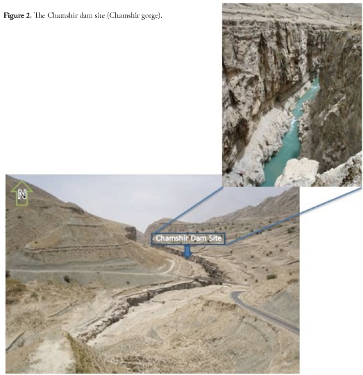
The Chamshir dam site on the Zuhreh river is located in south-western Iran, about 20 km southeast of the city of Gachsaran (50° 52' 36" E and 30° 10' 59" N, Figure 1). The dam is now being studied and has been designed as a 155 meter high concrete gravity-arc dam; its useful reservoir volume is 1.8 milliard cubic meters (Figures 1 and 2). Exceptional topographical, hydrological and geological circumstances regarding the river in the Chamshir gorge has led to the site being proposed as a suitable option for dam construction, concerning available national resources use (i.e. water storage for irrigation projects). So far some researchers have studied the rock mass conditions of the Chamshir dam site (e.g., Gharouni-Nik, 2008; Torabi-Kaveh et al., 2010).
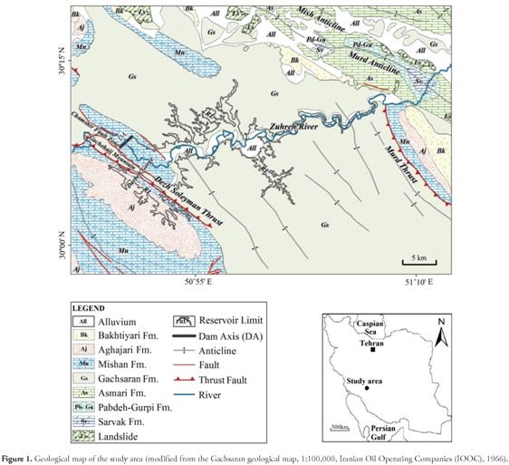
According to the 1:100,000 geological map of Ghachsaran (Seto-dehnia and O.B. Perry, 1966) (Figure 1), the geological formations in the study area, from oldest to youngest, are Gachsaran (early Miocene), Mis-han (early-Middle Miocene), Aghajari (Miocene-late Pliocene), Bakhtiari (late Pliocene-Pleistocene) and alluvial sediments. The Mishan formation (an isocline) along with the Gachsaran formation cover the western part of the dam reservoir and dam site. This formation has two different facies; the first consists of biohermy limestone and forms a great lens within a second facies which consists of alternating marl and limestone layers. The Zuhreh river has created the long and narrow Chamshir gorge by erosion of biohermy limestone, thereby making it a suitable location for dam construction (Figure 2). The Chamshir dam reservoir is located on the Gachsaran, Mishan and Aghajari formations; the Gachsaran formation's stratigraphy sequence in the study area is similar to that of the Khuzestan area (Tehran-Sahab and Parab-Fars Consulting Engineering Companies, 1997). This formation has 7 members: the oldest member is 40m thick consisting of alternating thick anhydrite, limestone and shale layers. The second member is a 115m thick salt layer, with anhydrite alternating with thin limestone layers. The third member is a 347m thick anhydrite layer with salt. The fourth member consists of a 290m thick salt layer with marl, gray limestone and anhydrite. The fifth member is 342m thick red and gray marl with alternating layers of gypsum. The sixth member is
This paper explains the engineering geological assessment involved in the safe design of the proposed Chamshir dam site. Such geotechnical investigation has been carried out at the project site and in the laboratory. Various laboratory tests and detailed discontinuity surveying were performed to assess rock mass characteristics.
The Chamshir dam site rock mass was studied using RQD, RMR and DMR classification and kinematic analysis more accurately assessed the dam foundation.
Geological setting
Geological factors play a major role in designing and constructing a dam (Ichikawa, 1999) as they control the nature of geological formations and also provide the needed materials for construction.
Many cases have occurred throughout the world where dam foundation rock mass conditions were not sufficiently known and the cost of construction and treatment greatly exceeded the original budget.
258m thick, having alternating layers of anhydrite (or gypsum), salt, red marl and limestone. The seventh member is the youngest member, being 139m thick and having alternating gypsum, gray marl and limestone layers. It should be mentioned that sulphate layers outcrop as gypsum on the surface and as anhydrite at deeper levels. The Gachsaran formation covers most parts of the projected dam reservoir (Figure 1). According to field observations, members 5, 6 and 7 of the Gachsaran formation would be in contact with the dam reservoir in this area and only member 7 outcrops downstream of the dam. The Aghajari formation would form a small part of the reservoir at its south-western corner and consists of sandstone, siltstone, conglomerate, gypsum and marl. Young and old terraces are also present along the banks of the Zuhreh river (Figure 1), consisting of coarse grained gypsum particles and fine grained silt and sand sediment.
The study area is in the Zagros folded area or external Zagros (Stock-lin, 1968) and simply folded belt (Berberian, 1995). Zagros folding com-pressional tectonic forces have created some faults and thrust faults having a NW-SE trend in the study area; the Dezh Soleyman thrust (DST), Murd thrust and Chamshir fault area are the most important ones (Figure 1).
The role of the DST in the study area is important according to field observations. The Gachsaran formation is uplifted along this fault from deeper parts to the surface. It has dissected some parts of the Mishan formation in the north-eastern branch of the Chamshir syncline and has consequently thrust the Gachsaran formation over the Mishan formation. The extensive tectonic pressure of the DST created the important Chamshir fault area, this being the source of several springs throughout this area and the DST. The Zuhreh river's deviation from its direct pathway into the Chamshir fault area could also provide reasonable evidence of tectonic activity in the study area.
Materials and Methods
Engineering geological investigations and rock mechanics studies include discontinuity surveying, core drilling, in situ and laboratory testing. Quantitative description of discontinuity (i.e. orientation, spacing, persistence, roughness, aperture and filling materials) were determined in situ by exposure logging according to the International Society for Rock Mechanics' (ISRM) standards (1981). Laboratory tests were carried out on the core samples to quantify the physical and geomechanical properties of intact rocks at the dam site.
Site investigation
The dam site was investigated in two stages; the site was geologically studied and mapped in detail. Thirty-four boreholes were drilled (1,578 m), 8 of them pertaining to the dam site. Six boreholes were drilled (565m total depth) during the first stage (1999 to 2000); the second stage was carried out between 2008 and 2009 when 2 boreholes were drilled (246 m total depth). Two locations have been have been considered for field studies regarding the proposed areas for constructing a dam in the Cham-shir gorge (Figure 3). Five hundred discontinuities were measured (250 on both the left and right abutments). Four dominant discontinuity sets were identified on the left (area 1) and right (area 1 and 2) abutments of the proposed dam site (Tables 1 and 2). Five dominant discontinuity sets were identified (Table 2) for the left abutment (area 2). A quantitative description of discontinuity in two areas included type and orientation in the left and right abutments (Tables 1 and 2).


Results and Discussion
Rock mass quality
RQD and RMR were also used for obtaining the exposed rocks' engineering properties within the dam foundation. The data were collected from the dam site. The RQD values were determined by examining drill cores and joint frequency (Table 3). The Table shows that the left and right abutments' RQD values were excellent for the projected dam construction.

Table 4 gives the RMR values, rock unit quality being classified as very good.

DMR classification
DMRSTA (related to dam stability against sliding) value was:

where RMRBD (basic dry RMR) resulted from adding the RMR's first four parameters plus a water rating of 15 and RSTA was the dam stability adjustment factor.
Regarding Hoek-Brown criteria, Hoek has advocated the use of a "dry RMR" obtained with the maximum rating for water, simultaneously introducing real pore pressures into the computations (Hoek et al., 2002).
RMRBD was obtained by adding the first four parameters of RMR plus 15:
1) Compressive strength, tested in water conditions similar to future ones, i.e. saturated when the rock is going to be saturated and having the same pH as that water;
2) Rock mass RQD;
3) Significant governing joints' spacing (s);
4) Significant governing joints' conditions (s); and
5) Water rating (WR), always 15 (as if dry).
The Rsta (adjustment factor for dam stability) was obtained (Table 5). The danger of sliding became reduced when the significant joint's dip direction was not almost parallel to the dam's downstream-upstream axis due to the geometrical difficulties involved in sliding. Such effect could be taken into account by multiplying dam stability adjusting factor rating RSTA by a geometric correction factor (CF):


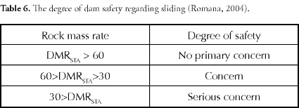
where adwas dam axis upstream-downstream direction and ajwas the dip direction of the significant governing joint. Dam foundation status DMRSTA was calculated (Table 6).
The Chamshir dam will built on Mishan limestone and marl rock units. The valley walls at the dam site are steep, having 80 90 slopes on the left abutment and 75 90 on the right abutment. The valley runs NW-SE (310°). Dip direction is 40° NE for the left abundant and 220°
SW for the right abundant. DMR classification for the Chamshir dam's foundation (for areas 1 and 2) is shown in Tables 4 and 5.
The results obtained from DMR classification (Tables 7 and 8) indicated that the left abutment (area 2) was instable; the results of this classification were compatible with field conditions.


Kinematic analysis
Kinematic refers to the motion of bodies without referring to the forces causing them to move (Goodman, 1989). Kinematic analysis is very useful for investigating possible rock mass failure modes and determining maximum safe slope angle (MSSA). Many studies have determined slope failure modes (Markland, 1972; Goodman, 1976; Goodman and Shi, 1985; Matherson, 1988) and evaluated slope stability (Ozsan and Akin, 2002; Aksoy and Ercanoglu, 2007; Kulatilake et al., 2011) using a stereographic projection technique. Kinematic analysis was used for the study area to estimate the MSSA regarding the three basic failure modes: plane sliding, wedge sliding and toppling.
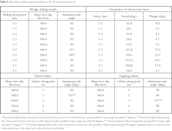
The aforementioned kinematic analysis was performed for left abutment slopes (area 2) at the dam site using dominant discontinuity sets.
Kinematic analysis (Table 9 and Figure 4) results indicated that joint inclination was the most important parameter affecting rock mass instability. The analysis revealed possible wedge, planar and toppling failures in the left abutment (area 2).

Conclusions
The concrete Chamshir dam will be located on the limestone and marl rocks of the Mishan formation. Good rock mass quality was indicated for these rocks; however, according to DMR and kinematic analysis, most parts of the dam foundation (except the left abutment, area 2) were safe, being rated low-risk in terms of instability occurrence and magnitude. It is therefore recommended that slope failure should be constantly monitored.
Despite RQD and RMR values showing favourable condition for the dam abutments, the DMR classification provided more accurate assessment and was more reliable, i.e. considerable correlation between such classification and the kinematic analysis.
Acknowledgments
The study was financed by the Mahab Ghodss Consulting Engineering Company. The authors are grateful to Dr. Hamid Reza Zarei for supplying the authors with the dam site's practical test data and Mr. Jason Garry for editing the paper in English and Mr. Mirmohammad Miri for translating it.
References
Aksoy, H. and Ercanoglu, M. (2007). Fuzzified kinematic analysis of discontinuity-controlled rock slope instabilities, Eng Geol. 89, 20919. [ Links ]
Berberian, M. (1995). Master "blind" thrust faults hidden under the Zagros folds: active basement tectonics and surface morphotectonics, Tectonophysics. 241, 193-224. [ Links ]
Bianewski, Z. T. (1989). Engineering Rock Mass Classification, Wiley, Chichester, 251 pp. [ Links ]
Deere, D. U. (1964). Technical description of cores for engineering purposes, Rock. Mech. Eng. Geol. 1, 17- 22. [ Links ]
Di Salvo, C. A. (1982). Geomechanics classification of the rock mass at Segunda Angostura Dam, 14th ICOLD, Rio de Janeiro, Q53 R30. [ Links ]
Gharouni-Nik, M. (2008). Comparison of the results of FDT and PLT in determining deformability modulus of the rock mass in the Chamshir dam site in Iran, The 3rd International Conference on Site Characterization, Taipei, Taiwan, 1-4 April. [ Links ]
Goodman, R. E. (1976). Methods of geological engineering in discontinuous rocks, San Francisco, West Publishing. [ Links ]
Goodman, R. E. (1989). Introduction to rock mechanics, 2nd ed. New York, Wiley. [ Links ]
Goodman, R. E. and Shi, G. H. (1985). Block theory and its application to rock engineering, New Jersey, Prentice-Hall. [ Links ]
Hemmen. (2002). Paris dam, internet site for DMR dams foundations, http://www.stmr.es. [ Links ]
Hoek, E., Carranza-Torres, E. and Corkum, B. (2002). Hoek-Brown failure criterium-2002 edition, NARMS, Toronto. http://www.google.com/earth/index.html [ Links ]
Ichikawa, K. (1999). Geological investigation of dams, Proc. of 2nd Asian Symposium on Engineering Geology and the Environment, Malaysian National Group, Bangi, Malaysia, 1-441-57. [ Links ]
ISRM. (1981). Rock characterization, testing and monitoring, In: Brown, E.T. (Ed.), ISRM Suggested Methods, Pergamon Press, Oxford, 211pp. [ Links ]
Kliche, C. A. (1999). Rock Slope Stability SME, Littleton, CO. [ Links ]
Kulatilake, P. H. S. W., Wang, L., Tang, H. and Liang, Y. (2011). Evaluation of rock slope stability for Yujian River dam site by kinematic and block theory analyses, Computers and Geotechnics. 38, 846860. [ Links ]
Marcello, A., Eusepi G., Olivero, S. and Di Bacco, R. (1991). Ravanasella dam on difficult foundation, 17th ICOLD, Vienna, Q 66 R 21. [ Links ]
Markland, J. T. (1972). A useful technique for estimating the stability of rock slopes when the rigid wedge sliding type of failure is expected, Imp, Coll, Rock Mech, Res, Rep, 19, 10. [ Links ]
Matherson, G. D. (1988). The collection and use of field discontinuity data in rock slope design, Q J Eng Geol. 22, 1930. [ Links ]
Ozsan, A. and Akin, M. (2002). Engineering geological assessment of the proposed Urus dam, Turkey, Eng Geol. 66, 27181. [ Links ]
Ramamurthy, T. (2004). A geo-engineering classification for rocks and rock masses, International Journal of Rock Mechanics & Mining Sciences. 41, 89101. [ Links ]
Romana, M. (2003a). DMR (Dam Mass Rating). An adaptation of RMR geomechanics classification for use in dams foundations, Int. Cong. On Rock Mechanics, (Technology roadmap for rock mechanics) South African Inst, Of Min, and Meta, 977-980. [ Links ]
Romana, M. (2004). DMR (an adaptation of RMR), a new geomechanics classification for use in dams foundations, 9th Congresso Luso de Geotecnia, Aveiro, 12pp. [ Links ]
Setudehnia, A. and OB-Perry, G. T. (1966). Geological map of Gachsaran, Iranian Oil Operating Companies (IOOC), 1,100,000. [ Links ]
Stocklin, J. (1968). Structural history and tectonics of Iran: a review, AAPG Bull. 52, 1229-1258. [ Links ]
Tehran Sahab and Parab Fars Consulting Engineering Companies. (1997). Engineering geology report concerning the Chamshir dam site (in Persian), Chamshir Dam project, Teheran, Iran. [ Links ]
Torabi-Kaveh, M., Heidari, M., Zarei, H. R. and Ghiasi, M. B. (2010). Engineering geological investigation of the foundation of the Chamshir dam site by use of DMR classification (Iran), 7th International symposium on eastern Mediterranean geology, University of Çukurova, Adana, Turkey, 18-22 October. [ Links ]
Van Schalkwyk. (1982). Geology and selection of the type of dam in South Africa, 14th ICOLD, Río de Janeiro, Q51. R44. [ Links ]

