


Services on Demand
Journal
Article
 English (pdf)
 Article in xml format
 Article references
 Send this article by e-mail
Indicators
-
 Cited by SciELO
 -
 Access statistics
Related links
-
 Cited by Google
 -
 Similars in
SciELO
Similars in
SciELO -
 Similars in Google
Share

 Permalink
Earth Sciences Research Journal
Print version ISSN 1794-6190
Earth Sci. Res. J. vol.16 no.1 Bogotá Jan./June 2012
Interpreting gravity anomalies in south Cameroon, central Africa
Yves Shandini1 and Jean Marie Tadjou2*
1 Physics Department, Science Faculty, University of Yaoundé I, Cameroon.
2 National Institute of Cartography- NIC, Yaoundé, Cameroon
* Corresponding author. E-mail: shandiniyves@yahoo.fr
Record
Manuscript received: 14/10/2011 Accepted for publications: 06/05/2012
ABSTRACT
The area involved in this study is the northern part of the Congo craton, located in south Cameroon, (2.5°N - 4.5°N, 11°E - 13°E). The study involved analysing gravity data to delineate major structures and faults in south Cameroon. The region's Bouguer gravity is characterised by elongated SW-NE negative gravity anomaly corresponding to a collapsed structure associated with a granitic intrusion beneath the region, limited by fault systems; this was clearly evident on an isostatic residual gravity map. High gravity anomaly within the northern part of the area was interpreted as a result of dense bodies put in place at the root of the crust. Positive anomalies in the northern part of the area were separated from southern negative anomalies by a prominent E-W lineament; this was interpreted on the gravity maps as a suture zone between the south Congo craton and the Pan-African formations. Gravity anomalies' total horizontal derivatives generally reflect faults or compositional changes which can describe structural trends. The local maxima of the Bouguer gravity data's horizontal gradient grid and its upward continuation at various altitudes were used to highlight the deepest lineament faults and their dip and direction. These features led to producing a structural map of the study area.
Keywords: fault, gravity data, isostatic residual gravity, south Cameroon, total horizontal derivative.
RESUMEN
El área involucrada en este estudio es parte del norte del cratón del Congo, localizada en el sur de Camerún, (2.5°N - 4.5°N, 11°E - 13°E). Se realizo un análisis de los datos de gravedad para delinear las principales estructuras y fallas en el sur de Camerún. La gravedad de Bouguer de la región se caracteriza por una alargada anomalía de gravedad negativa, con tendencia SW-NE, que corresponde a una estructura colapsada asociada con una intrusión granítica debajo de la región, limitada por un sistema de fallas; esto fue claramente evidenciado sobre un mapa de gravedad residual isostático. Las altas anomalías de gravedad dentro de la parte norte de la zona fueron interpretadas como resultado de cuerpos densos colocadas en la raíz de la corteza. Las anomalías positivas en la parte norte de la zona fueron separadas de las anomalías negativas del sur por un lineamiento prominente con tendencia E-W; esto fue interpretado en los mapas de gravedad como una zona de sutura entre el sur del cratón del Congo y las formaciones Pan-Africano. Las anomalías de gravedad de los derivados horizontales totales generalmente reflejan fallas o cambios en la composición, las cuales pueden describir las tendencias estructurales. La máxima local derivada de los datos de la malla de gradiente horizontal de la gravedad de Bouguer y su continuidad hacia arriba en diferentes altitudes fueron usadas para resaltar los lineamientos más profundos de las fallas y su inclinación y dirección. Estas características permitieron producir un mapa estructural del área de estudio.
Palabras claves: Falla, datos gravitacionales, gravedad residual isostática, Sur Camerún, derivada horizontal total.
Introduction
The study area was located on the northern margin of the Congo craton (CC) (2.5°-4.5°N, 11°-13°E). The study area was affected by a series of tectonic activity due to Pan-African fold belt interaction with the CC forming the south Cameroon area's structural features (Castaing et al., 1994; Abdelsalam et al., 2002; Toteu et al., 2006). The collision between the CC and Pan-African belt (PAB) led to the Pan-African units overthrusting onto the craton by about 50 to 150 km (Manguelle-Dicoum, 1998; Tadjou et al., 2004; Shandini et al., 2010). The basement configuration and faults cannot be mapped directly using conventional field methods Due to the blanket of Pan-African units whose thickness can be considerable in places. Even though geological and geophysical studies in Cameroon began more than 50 years ago, little is known about the south Cameroon area's subsurface structure. This study's main purpose was to compile available geological and gravity data regarding southern Cameroon to gain better understanding of its structural framework, basement configuration and construct a tectonic map of the study area.
Geological setting
The area being studied lies in south Cameroon, located in the transition zone between the CC and the West African PAB; its very complicated tectonic history has unfolded as it has undergone its geological evolution. A simplified geological sketch map of the study area illustrating the main geological units is shown in Figure 1.
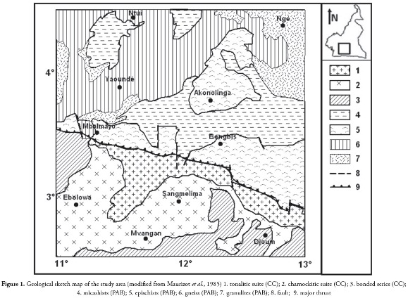
The Ntem complex represents the north-western part of the CC in Central Africa and is well exposed in South Cameroon (Maurizot et al., 1985).
The complex predominantly consists of younger intrusive complexes and banded series composed of gneisses. Intrusive complexes primarily consist of TTG suite rocks (Nédélec et al., 1990).
The TTG unit is made up of three rocks types: the tonalitic suite (known as So'o granite), the charnockitic suite and the granodioritic suite massifs (Shang et al., 2004).
The tonalitic suite is exposed to the north and is strongly mylonitised and retrogressed along the fault boundary with formations from the Yaoundé Group.
The Yaoundé group is a huge allochtonous nappe thrust southward onto the CC. It comprises low- to high-grade garnet-bearing schist, gneisses and orthogneisses transformed in medium- to high-pressure granulite facies metamorphism (Toteu et al., 2004). The Yaoundé group in the study area consists of the Mbalmayo-Bengbis series and the Yaoundé series known as "intermediate series." The Mbalmayo-Bengbis series are composed of schist and re-crystallised quartzite in greenschist facies (Vicat, 1998). The Yaoundé series consist of strongly deformed meta-sedimentary rocks and migmatites (Nzenti et al., 1988).
The structural data has shown definite surface deformation characterised by flat structures gently sloping to the north and generalised tilting towards the south or south-west, indicating a significant intermediate formation overlap on the Ntem complex basement. Such deformation may be seen by the presence of northward sloping folds. The region has a complex and uneven tectonic structure. The region's tectonic evolution seems to have given rise to the basement's vertical movement, with subsidence to the north and uplift to the south (Manguelle-Dicoum, 1988). This basement movement must have provoked irregularities in deep formations, giving rise to faults, horsts and grabens which are characteristic of the boundary between the CC and the Pan-African fold belt.
Data and Methods
The gravity data used in this work was obtained from the Institut Français de la Recherche Scientifique pour le Développement en Coopération's (ORSTOM) database. The data were collected in the area, using Worden gravimeters (n° 69, 135, 313, and 600), 0.2 mgals/division scale precision, and Lacoste & Romberg gravimeters (model G n° 471 and 823). The altimeter readings were looped along with gravimeter reading to obtain fairly reliable height differences between base stations, thereby guaranteeing reasonably accurate elevation values for intermediates stations. Maximum error in determining the height of any station by means of altimeters did not exceed 10 m. Consequently, Bouguer anomaly value maximum error for any station due to the above height determination error was not expected to exceed 0.15 mgal. The Bouguer anomaly values resulted from free-air reduction referring to the ellipsoid, infinite plate reduction with 2.670 g/cm3 constant reduction density and topographic reduction (Crenn, 1967; Collignon, 1968). Gravity survey accuracy was estimated to be about ± 0.5 mGal.
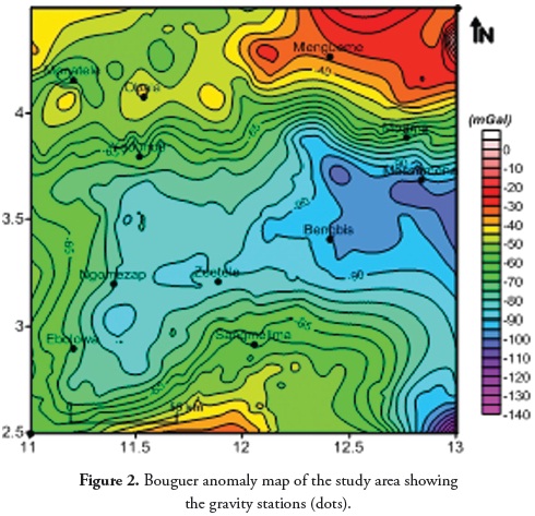
A Bouguer anomaly map (constant 5 mGal contour interval) was thus prepared to interpret the study area's crustal structure (Figure 2). The map revealed a large-scale negative Bouguer anomaly tending SW-NE to E-W over the central part of the area. Closer geological and structural observation (Figures 1 & 2) of this anomaly's axes suggested that its general trend followed an inferred granite intrusion area known as So'o granite. The quite different nature of the Bouguer gravity map on the northern side was marked by gravity highs, bounded by relatively steep gradients occurring over or near higher metamorphic formations (granulite, migmatite and micaschist) and other granitic plutons, suggesting the existence of a suture zone between two of the crust's blocks (Kennedy, 1964). Positive Bouguer gravity in the southern area tending SW-NE marked the intrusion of dense rocks (charnockites) in this area.
Interpreting gravity and magnetic data can be aided by applying advanced processing: total horizontal derivative and isostatic residual/regional processing for the Bouguer gravity map. Such techniques were applied here to aid understanding regional tectonics and structures.
Total horizontal derivative for gravity data
This operation measured the rate of change of field in x and y directions and created a resultant grid (Cordell and Grauch, 1985):
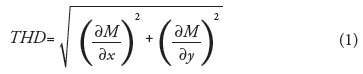
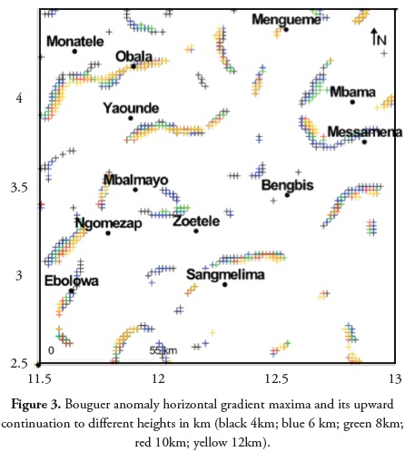
The horizontal gradient method was used to locate density boundaries from gravity data (Cordell and Grauch, 1985). This highlighted high gradient areas such as those which might occur at faulted boundaries. Local peaks (or ridges) in gravity horizontal gradient magnitude gave the steepest gradients' locations, this being intuitively similar to taking the first derivative of a curve. A 3x3 window was passed over the horizon tal gradient magnitude (HGM) grid in the automated method (Blakely, 1986) to fit parabolic peaks to the four 3-point scans passing through the centre of the window. If a sufficient number of peaks or maxima were found (usually 2 to 4), the location of the largest peak was taken as the contact location. This technique has been applied to upward-continued data at five depth levels: 4, 6, 8, 10 and 12 kilometres above measurement surface. The upward continuation processing of the Bouguer gravity map at various altitudes, followed by determining horizontal gradient maxima for each level yielded these maxima's progressive migration while increasing upward continuation altitude indicating the dip direction. Faults were presumed to produce a single alignment in map view, or one prominent HGM maxima "track".
Isostatic residual gravity anomaly
An isostatic reduction was applied to the Bouguer anomalies to quantify the isostatic compensation effects allowing isostatic equilibrium to be restored. The regional correction was calculated from topography using Airy's model of crustal compensation and subtracted from the Bouguer gravity anomaly, which then produced an isostatic residual gravity map of the study area. A crust having constant density ρc but changing thickness was hydrostatically supported by a denser substratum whose density was Ïm. If T were the thickness of the sea-level standard crust (Moho initial depth), H the height above sea-level of any crustal column having R as a root relative to the standard crust base, then the value of R was determined using an isostatic equilibrium equation (Schoeffler, 1975):
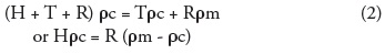
The isostatic reduction would then result in determining the R value for each H and computing its gravity effect from the relationship given below:

where Δρ = ρm - ρc mantle-crust density contrast.
Isostatic anomalies depict deviations from compensation, resulting from crust restructuring (density changes corresponding to short wavelength effects) and the lithospheric plate or upper mantle's elastic behaviour (deepest sources corresponding to long wavelength effects). The isostatic residual anomaly was calculated by removing the long wavelength gravity effects caused by isostatic compensation, i.e. variations in the crust/ upper mantle boundary. Theoretically, the isostatic residual should have only retained the gravity effects from the upper crust to the surface.
Results and Discussion
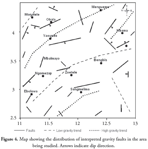
Analysing the results of the horizontal gradient map (4, 6, 8, 10, 12 km altitude; Figure 3) aided in defining the location of linear features related to the trend of the deep faults in this area. Faults could be traced easily along these salient features. The resulting set of lineaments (Figure 4) showed that most faults in the study area had sub-vertical dips. Interpreting the So'o granite complex's structural elements, in the central part of the area, revealed that it was bounded to the north and southwest of the Sangmelima region by main fractures interpreted as being normal faults. ENE-WSW sets of faults appeared in the southwest part of the study area, extending from south of Ebolowa to Mbalmayo. The NNWSSW tending fault in the Mbalmayo area was described as representing an intra-granitic fault (Manguelle-Dicoum et al., 1992). The gravity data for the northern part of the area was characterised by gravity highs, bounded by relatively steep gradients which could be interpreted as the result of mantle upwelling associated with high temperature; deep-seated basement structure associated-melting had thus occurred in the lower crust. Overall horizontal derivative analysis results for gravity anomalies produced many features regarding trend and dip direction marking the faulted CC and the PAB boundary and revealed a complex subsurface geological structure.
Regional correction was calculated from topography using Airy's crustal compensation model using Geosoft software (2009). The following parameters were selected for computation: 30 km initial compensating depth and 0.60 g/cm3 mantle-crust density contrast.
The isostatic residual anomaly was calculated by removing the long wavelength gravity effects caused by isostatic compensation, i.e. variations in crust/upper mantle boundary. The main isostatic residual map (Figure5) feature was similar to that of the Bouguer map shown in Figure 2.
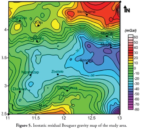
Prominent low gravity seen in the isostatic anomaly might have indicated a deepening of the basement, assuming that the isostatic correction had appropriately accounted for deep crustal gravity effects.
Low regional gravity reflected low density granitic rocks (So'o granites) making up the upper 8 km of a batholith in this region (Tadjou et al., 2004; Shandini et al., 2010); however, its strongest correlation with surface geology was not evident. The consistent relationship between broad gravity lows and granitic rock distribution was perhaps most clearly seen locally along the major thrust marking the contact between the CC and the Pan-African orogenic belt, near latitude 3.5°N. Although major low gravity sources appeared to be shallow, they were most likely concealed throughout much of the area. Some gradients defining the borders of the low occurred over exposed Pan-African formations. It could have been inferred that the faults dissecting and crosscutting the central low gravity area might have been fracturing the crust associated with massive granitic intrusion in the upper, brittle part of the crust.
Local gravity highs were the dominant feature in the northern part of the area. The positive anomalies occurring over or near higher metamorphic formation outcrops appeared to be associated with mafic igneous bodies. Shandini et al., (2010) used spectral analysis and 3D gravity modelling to provide evidence that the Bouguer anomaly on the northern edge of the CC could not be modelled without high-density intrusive-like deep bodies and attributed positive anomalies in this region to deep and dense intrusive bodies. A positive NW-SE trending anomaly was the dominant feature in the southern part of the area which could be interpreted in terms of TTG group igneous charnockite intrusion.
The transition from low to high background gravity values occurred over relatively short distances, suggesting that the density distributions producing these anomalies were shallow. The northern part of the area was separated from the southern part by a prominent E-W lineament expressed on Bouguer and isostatic residual gravity maps. Such extensive gravity gradients mark regional crustalscale subsurface structures considered suture zones between two of the crust's block. The general abundance of faults observed in the northern part of the area revealed complex subsurface geological structure. Crustal faulting in this area could have been related to the inferred tectonic boundary separating the CC and the PAB and was associated with deep-seated basement structures.
Conclusion
Gravity anomaly field maps present positive/negative anomalies separated by strong gradient zones. Multi-scale analysis of horizontal gravimetric gradient led to identifying the main faults responsible for structuring the studied area and so obtaining indications regarding their dip. The study area was characterised by one gravity anomaly in the south characterised by having a long wavelength and high anomaly expression in the north. Low gravity anomaly expression was associated with granite intrusions while high gravity anomaly expression was associated with basement outcrop. These two areas were separated by a pronounced E-W lineament recognised on both Bouguer and isostatic residual gravity maps and was interpreted as being a basement fault.
References
Abdelsalam, M.G., Liégeois, J.P. and R.J. Stern (2002): The Saharan metacraton. Journal of African Earth Sciences, 34, 119-136. [ Links ]
Archibald, N. and F. Bochetti (1999): Multiscale edge analysis of potential field data. Explor. Geophys., 30, 38-44. [ Links ]
Blakely, R.J. and R.W. Simpson (1986): Approximating edges of source bodies from magnetic or gravity anomalies. Geophysics,51, no.7, 1494-1498. [ Links ]
Castaing, C., Feybesse, J.L., Thieblemont, D., Triboulet, C., and P. Chevremont (1994): Palaeogeographical reconstructions of the Pan-African/ Brasiliano orogen; closure of an oceanic domain or intracontinental convergence between major blocks? Precambrian Research, 67, 327- 344. [ Links ]
Cordell, L. and V. J. S. Grauch (1985): Mapping basement magnetization zones from aeromagnetic data in the San Juan Basin, New Mexico, in Hinze, W. J., Ed., The utility of regional gravity and magnetic anomaly maps; Soc. Explor. Geophys., 181-197. [ Links ]
Crenn, Y. (1967): Mesures gravimétriques et magnétiques dans la partie centrale de l'A.O.F. Interprétation géologique. Publi. série géophys. ORSTOM, Paris, Fr., 43 p. [ Links ]
Collignon, F. (1968): Gravimétrie et reconnaissance de la République Fédérale du Cameroun ORSTOM Paris, 35p. [ Links ]
Geosoft, reference manual, 2009, software for Earth Sciences Geosoft INC., Toronto, Canada. [ Links ]
Kennedy, W.Q. (1964): The structural differentiation of Africa in the Panafrican 500 Ma tectonic episode. In; 8th Ann. Rep. Res. Inst. Afr. Géol. Leeds University, U. K.; 48-49. [ Links ]
Manguelle Dicoum, E. (1988): Etude Géophysique des structures superficielles et profondes de la région de Mbalmayo, 202 p. Thèse de Doctorat, Université de Yaoundé I, Cameroun. [ Links ]
Manguelle-Dicoum, E., Bokosah, A.S. and T.E. Kwende Mbanwi (1992): Geophysical evidence for a major Precambrian schist- granite boundary in southern Cameroon. Tectonophysics, 205, 437-446. [ Links ]
Maurizot, P., Abessolo, A., Feybesse, J., Johan and P. Lecomte (1985): Etude et prospection minière du Sud-Ouest du Cameroun. Synthèse des travaux de 1978 à 1985. Rapport BRGM 85 CMR 066, 274p. [ Links ]
Nédélec, A., Nsifa, E.N. and H. Martin (1990): Major and trace element geochemistry of the Archaean Ntem plutonic complex South Cameroon; petrogenesis and crustal evolution. Precambrian Research, 47, 35-50. [ Links ]
Nzenti, J.P., Barbey, P., Macaudière, J. and D. Soba (1988): Origin and evolution of the late Precambrian high,grade Yaoundé gneisses Cameroon. Precambrian Research, 38, 91-109. [ Links ]
Schoeffler, J., 1975. Gravimétrie appliquée aux recherches structurales et à la prospection pétrolière et minière. Edition Technip. Paris, France. 288p. [ Links ]
Shandini Y, Tadjou J and Basseka C. Delineating Deep Basement Faults of South Cameroon Area. World Applied Sciences Journal, 14 (4), 611-615, 2011 source for this article. [ Links ]
Shandini, N.Y., Tadjou, J.M., Tabod, C.T. and J.D. Fairhead, (2010): Gravity data interpretation in the northern edge of the Congo Craton, South-Cameroon. Anuário do Instituto de Geociências, 33 (1), 73-82. [ Links ]
Shang, C.K., Satir, M., Siebel, W., Nsifa, E.N., Taubald, H., Liégeois, J.P. and F.M. Tchoua (2004): TTG magmatism in the Congo craton, a view from major and trace element geochemistry, Rb-Sr and Sm-Nd systematics; case of the Sangmelima region, Ntem complex, southern Cameroon. Journal of African Earth Sciences, 40, 61-79. [ Links ]
Tadjou, J.M., Manguelle-Dicoum, E., Tabod, C. T., Nouayou, R., Kamguia, J., Njandjock, N. P. and M. T. Ndougsa (2004): Gravity modelling along the northern margin of the Congo craton, South,cameroon. Journal of the Cameroon Academy of Sciences, 4 (1), 51-60. [ Links ]
Toteu, S.F., Fouateu, R.Y., Penaye, J., Tchakounte, J., Mouangue, A.C.S., Van Schmuss, W.R., Deloule, E. and H. Stendal (2006): U-Pb dating of plutonic rocks involved in the nappe tectonics in southern Cameroon; Consequence for the Pan-African orogenic evolution of the central African fold belt. Journal of African Earth Sciences, 44, 479-493. [ Links ]
Toteu, S.F., Penaye, J. and Y.D. Poudjom (2004): Geodynamic evolution of the Pan-African belt in central Africa with special reference to Cameroon. Canadian Journal of Earth Sciences, 41, 73-85. [ Links ]
Vicat, J.P. (1998): Esquisse géologique du Cameroun. Géosciences au Cameroun, GEOCAM, 1,3-11. [ Links ]

