


Services on Demand
Journal
Article
 English (pdf)
 Article in xml format
 Article references
 Send this article by e-mail
Indicators
-
 Cited by SciELO
 -
 Access statistics
Related links
-
 Cited by Google
 -
 Similars in
SciELO
Similars in
SciELO -
 Similars in Google
Share

 Permalink
Earth Sciences Research Journal
Print version ISSN 1794-6190
Earth Sci. Res. J. vol.18 no.1 Bogotá Jan./June 2014
https://doi.org/10.15446/esrj.v18n1.39966
http://dx.doi.org/10.15446/esrj.v18n1.39966
METEOROLOGY
Climate Variability and its impacts on runoff in the Kosasthaliyar sub-basin, India
Balambal Usha1 and B V Mudgal2
1. Research Scholar, Centre for Water Resources, Anna University Chennai. Email: u_seshadri@rediffmail.com
2. Professor, Centre for Water Resources, Anna University Chennai.
Record
Manuscript received: 19/09/2013 Accepted for publication: 31/05/2014
ABSTRACT
Research on the effect of climate variability/climate change on runoff is limited in humid tropical regions. Climate change has implications beyond the water resources sector, such as effects on agriculture and fisheries. Hence, such studies are becoming increasingly important. This study uses both historical field data and future climate forecasts from General Circulation Model Hadley Centre Coupled Model, version 3 GCM HadCM3. These data are further downscaled using third generation of the Hadley Centre's regional climate model (HadRM3), with Providing REgional Climates for Impacts Studies (PRECIS) software under the three Quantifying Uncertainties in Model Projections (QUMPs) with a horizontal resolution of 25 km X 25 km by the Centre for Climate Change and Adaptation Research, Anna University Chennai, for the state of Tamil Nadu. These downscaled data are used to study runoff changes due to climate change for the Kosasthaliyar sub-basin in South India. A trend analysis of the hydro-meteorological data for the sub-basin indicates that future rainfall is expected to decrease by approximately 10%, while the mean temperatures will increase by the year 2100. The runoff changes from 2011 to 2040 are not perceptible when compared to the historical period of 1971 to 2000. This study attempts to provide information on climate variability and its impacts on runoff in the Kosasthaliyar sub-basin.
Key words: GCM, HadCM3, HadRM3, QUMP, runoff.
RESUMEN
La investigación del efecto variabilidad climática/cambio climático en el modelo pluviosidad/escorrentía es limitada en regiones tropicales húmedas, donde el cambio climático tiene implicaciones tanto en los recursos acuíferos, como en la agricultura y la pesca. Por lo tanto este tipo de estudios han incrementado su importancia. Este estudio utiliza tanto los datos adquiridos en este campo como las predicciones climáticas del Modelo General de Circulación de la Célula de Hadley, en su versión 3GCM HadCM3. Estos datos fueron reducidos luego al utilizar la tercera generación del modelo climático regional del Centro Hadley (HadRM3), con el programa de Estipulación de Climas Regionales para Estudios de Impacto (PRECIS, en inglés), bajo los tres modelos de Cuantificación de la Incertidumbre en Proyecciones (QUMPs, en inglés). El Centro para el Cambio Climático y la Investigación de Adaptación de la Universidad Anna, de Chennai, en el estado Tamil Nadu, utiliza una escala horizontal de 25 kilómetros por 25 kilómetros. Esta reducción de datos se utiliza para estudiar los cambios de escorrentía por el cambio climático en la subcuenca de Kosasthaliyar, al sur de la India. Un análisis de tendencia de los datos hidrometeorológicos en la subcuenca indica que en el futuro la pluviosidad caerá en un 10 %, mientras que la temperatura media se incrementará para el año 2100. Los cambios de escorrentía para el período 2011-2040 no difieren de los del período 1971-2000. Este estudio es uno de los primeros acercamientos para proveer información sobre la variabilidad climática y sus impactos en la escorrentía de la subcuenca de Khosastaliyar.
Palabras clave: GCM; HadCM3; HadCM3; QUMP; Escorrentía.
Introduction
Evidence is mounting that climate change is occurring (Alavian et al (2009)). Every region of the world is expected to experience climate change. The impact of climate change on water resources may be positive or negative, depending on the geographical region (Rao et al (2012)).
Each river basin faces a unique set of climate-related water challenges, depending on the hydrological regime. The extent that each water system will be affected by climate change will depend on the area's degree of vulnerability, including its internal capacity to adapt to such change. Internal capacity refers to the ability or resilience of the system to cope with this externality.
In general, warming increases the variability in precipitation, i.e., the number of rainy days may decrease, while the intensity of rainfall may increase (Mukerji 2009). This trend is likely to create excessive runoff within a short period (Mall et al, 2006). Additionally, as the atmosphere warms, the evaporation from soil moisture increases (Chattopadhyay and Hulme 1997; Mall et al 2006).Runoff is decreasing in some regions and increasing in other regions. Whether runoff increases or decreases in a region is basin-specific within the context of climate change.
Meteorological data are fundamental inputs for hydrological investigations. A critical issue is that "due to changing climate past data and hydrological experience may no longer be a guide for decision making", i.e., the stationarity of climate, which is a key assumption in planning for water resources, is no longer valid [EBNFLO Environmental Aqua Resource Inc.(2010)]. Hence, all impact assessments of climate change will need to incorporate a wide range of climate scenarios to study the potential of future water resources potential. The study was conducted by considering the above factors. The main aim is to assess the impacts of climate variability on the reservoir inflows of the major reservoirs located within the sub-basin of Kosasthaliyar.
A number of authors have used WEAP (Water Evaluation and Planning System) to study stream flow impacts under climate change. A notable study was conducted by Harma (2010) on the Okanagan Basin in British Columbia. In this study, land use and climate, which are changing simultaneously, were considered for modeling stream flows using WEAP. The results demonstrate that all future climate conditions will critically reduce streamflows relative to the societal and ecological demands in at least a few months of "normal" and "dry" years. In all cases, the combination of demand, reservoir operations and climate variability will result in less than optimal conditions for instream flow needs.
In another study by Yates et al (2009), the Sacramento Basin in California was chosen to study the effects of climate change on reservoir inflows. The Sacramento Basin was divided into more than 100 sub-basins. A 37-year monthly climate time series from 1962 to 1998 was applied to a distributed hydrological model in WEAP. The results showed that the WEAP model was able to simulate the inflows well for this period.
The problem
The IPCC (2007) AR4 states that India could suffer from water stress - an annual water availability of less than 1000 cubic meters per capita - by 2025, and groundwater availability could decrease as much as 37 percent by mid-century. Chennai Basin is situated in a humid tropical climate in South India. Water availability in this region depends on rainfall, particularly its spatial and temporal distribution. The basin receives approximately 1300 mm of rainfall annually. Approximately 90 percent of this annual rainfall is received from two monsoons spread over a period of six months from June to December. The remaining rainfall occurs during a six-month period encompassing the summer months. Most of the reservoirs in the basin are sources of domestic water for the city (indicated in the Chennai Basin Micro Level Report). Hence, the inflow into these reservoirs is very important because it dictates the supply of water for the basin. Groundwater, which is a major water source, has been subjected to large withdrawals. Therefore, surface water resources must be judiciously conserved and managed.
Quantifying hydrological responses to climate change is extremely important for proper water resources management (IPCC 2007). Global climate models (GCMs) are the best tools to study climatic variations at the global scale. However, GCMs do not capture local details, which are necessary for impact assessments at the regional level. Hence, there is a need to link the output from GCMs by further downscaling so that they can be used as input for hydrological modeling at basin level . So far, such studies have apparently not been reported at the regional level for Chennai Basin.
Study area and methodology
3.1 Study Area
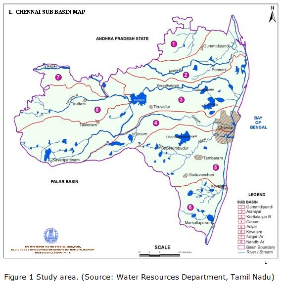
Chennai Basin is situated in South India. The Kosasthaliyar sub-basin is the part of Chennai Basin located between 12°40'N-13°40'N and 79°10'E-80°25'E at the northeast corner of Tamil Nadu. The total area of the basin is 7282 km2, 5542 km2 of which is in Tamil Nadu; the remaining area is in Andhra Pradesh. The Kosasthaliyar sub-basin covers an area of 2013.58 km². The Poondi Reservoir is a single purpose reservoir that was constructed in 1944 as a source of drinking water for the city of Chennai. Cholavaram and Red Hills are the other two reservoirs of the Kosasthaliyar sub-basin. The map of the study area is given in Figure 1.
3.2 Trend Analysis
The non-parametric Mann-Kendall (MK) test (Mann, (1945); Kendall, (1975)) has been commonly used to assess the significance of trends in hydrometeorological series (Chiew and McMohan 1993 and others). First, the presence of a monotonic increase or decrease has been tested using the slope of the linear trend estimated from regression analysis. Second, the significance of the trend is estimated using the Mann -Kendall method.
3.3 WEAP model
The Water Evaluation and Planning System (WEAP) is a physically based, semi-distributed river basin model developed by the Stockholm Environment Institute. WEAP was developed to assess water resource allocation problems, and it is also used to study the impacts of climate change on hydrology. It is a complex integrated river basin model that operates with a flexible time step, i.e., hourly, daily, etc. The WEAP rainfall runoff model requires data on soil, land use, climate, etc., for the assessment of water resource availability at desired locations of a drainage basin.
3.4 Research Stages
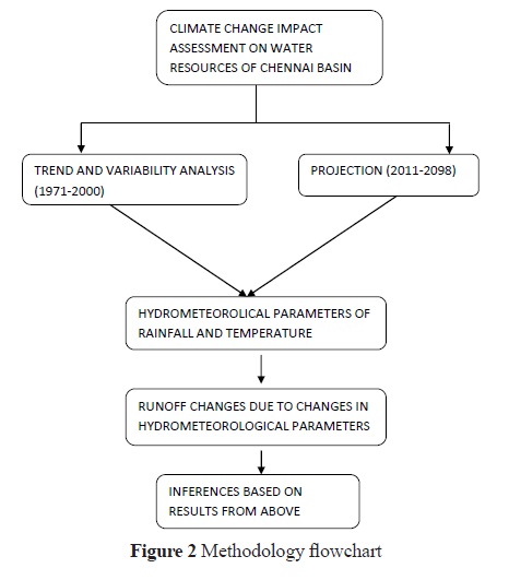
The methodology flowchart is given in Figure 2 below.
To conduct this research, rainfall and temperature field data of the past 30 years were analyzed; subsequently, the virgin flows for the same 30-year historical period (1971-2000) were used to develop a hydrological model. The rainfall and temperature data are used to drive the model to study past runoff impacts. Along with this analysis, RCM data of rainfall and temperature for the same period are used to simulate the runoff. Then, the results from the two simulations are compared. Furthermore, RCM data are used for predicting future flows for the period of 2011-2040.
For past impact analysis, field data of monthly rainfall and virgin flows were obtained from the Institute for Water Studies, Taramani, Chennai. Data for temperature were obtained from the IMD (India Meteorological Department).
To study the future changes in the basin, 120 years of daily climatic data were obtained by dynamically downscaling GCM HadCM3 output using PRECIS software. The A1B emission scenario under the three QUMP (Quantifying Uncertainties in Model Projections) was considered. The spatial resolution of HadRM3 (Regional Climate Model) was 25 km X 25 km.
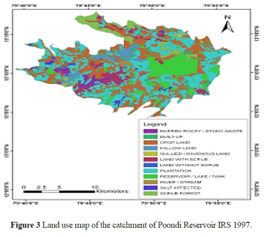
A land use map from satellite images was obtained from the Institute of Remote Sensing (IRS) , Anna University, Chennai. The land use map of the catchment of Poondi Reservoir is given in Figure 3.
Data for the WEAP input parameters, such as soil water capacity, hydraulic conductivity, crop coefficients, net irrigated area, deep water capacity and deep conductivity, were obtained from the Institute for Water Studies, Chennai. The leaf area index (LAI) was calculated by using the FAO method. The leaf area index is obtained from crop coefficients of both the mid-season and harvesting season. The initial value of the crop coefficient is 0.1.
To assess the effects of climate change on future flows, WEAP was used to first calibrate and validate the model for the Kosasthaliyar reservoirs with virgin flow data. A monthly time step was selected, as climate change is a long-term phenomenon. Hence, monthly flows aggregated to annual flows were considered more representative of stream flows than shorter time steps.
Upon consultation with a few field experts, it was found that the catchment of the Red Hills is a highly urbanized sub-watershed. The virgin flows into both the Red Hills reservoir and the Cholavaram tank are negligible. The runoff from Kosasthaliyar is stored in Poondi Reservoir. Therefore, only the virgin flows of Poondi were considered, and the watershed was considered a single reservoir system. The stream flows were modeled accordingly.
Results and discussion
4.1 Trend Analysis - Past (1971-2000)
The main aim of this paper is to study the climate variability impacts on runoff. Therefore, a detailed description of the work conducted on trend analysis is not presented. Instead, a snapshot of the results of the trend analysis is shown in Figure 4. An initial analysis indicates increases for both rainfall and temperature during 1971-2000 (control climate). The MK test at a significance level of 0.85 showed that these trends are statistically significant. Further rainfall and runoff trends for the sub-basin of Kosasthaliyar showed an increase.
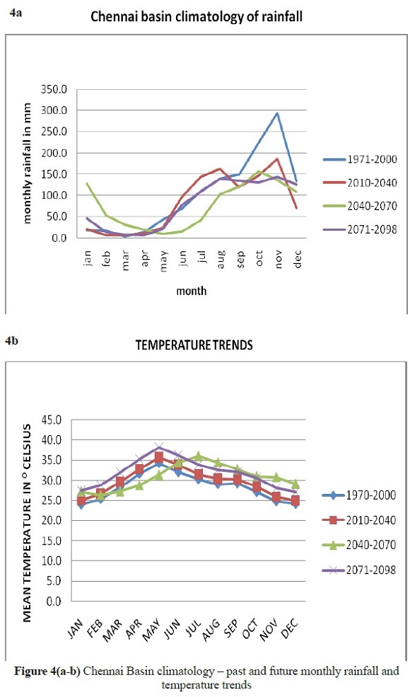
4.1 Trend Analysis - Future (2011-2100)
The graphs show that rainfall will decrease in the coming years, whereas temperatures will increase. The maximum mean temperature (during May) is likely to increase from 34.5 degrees Celsius in 1970-2000 to 37.5 degrees Celsius by 2098.
4.3 WEAP Model
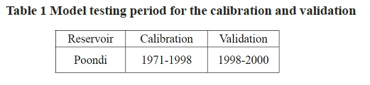
The upstream catchment of the Poondi Reservoir was considered for the analysis. The same period of analysis was taken into consideration, where1971-2000 is the control period and 2011 - 2040 is the future climate. The runoff in relation to the rainfall for the Kosasthaliyar Basin was plotted. The runoff increases in accordance with the rainfall for this sub-basin. To test the statistical significance of this trend, the Mann-Kendall test was performed using XLSTAT. The trend is statistically significant at the significance level of alpha equal to 0.3 with a p-value of 0.288. To assess the effects of climate change on future flows, WEAP was used to first calibrate and validate the model for the Poondi Reservoir with virgin flow data. For rainfall data that used field data for the first simulation run, the mean of five relevant rain gauge stations was considered for the analysis. For the second simulation run using RCM data, a monthly bias correction factor was applied to the RCM rainfall data for the average rainfall of the nearby grids because there were seasonal biases compared to the field data. Literature on RCM studies indicates that RCM data should never be used in hydrological studies without bias correction (Maraun et al 2010). The details of the calibration and validation periods are given in Table 1.
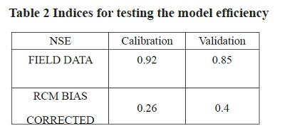
The model performance was assessed using NSE and other indices, as shown in Table 2.The Nash Sutcliffe efficiency (NSE) produced very high values for both the calibration and validation of the field data. For the RCM-derived runoff, the NSE values were within an acceptable range. Per the performance rating recommended by Moriasi et al (2007) for the monthly time step, this model is very good for Chennai Basin.
4.4 Future Impacts on Runoff of the Kosasthaliyar Sub-basin
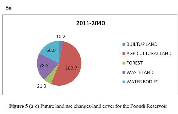
The WEAP model was used to predict inflows under climate change. To build a future scenario, a single land use change was considered for each decade i.e., 2011-2020, 2021-2030 and 2031-2040. For Poondi, the change in land use was an increase in the wasteland, which leads to a reduction in water bodies, as shown in Figure 5. It might be noted that there were no major perceptible changes in the land use extrapolated for the future period. This process, coupled with climate change under the A1B emission scenario, was used to model future inflows. These results are graphically represented in Figure 6.
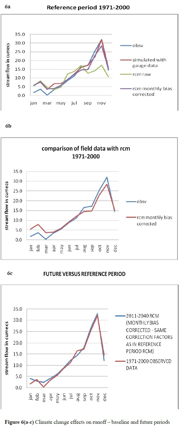
The graphs show that overall, there will be no significant change in the runoff in the coming years.
Conclusions
In this study, runoff changes due to climate change were investigated for the Kosasthaliyar sub-basin, South India. Both past and future impacts on runoff were mapped using field data and climate model data, i.e., data from RCM PRECIS using a horizontal resolution of 25 km X 25 km. The climatic data obtained were superimposed on a hydrological model using WEAP software. From a trend analysis of the climatic data and runoff data, the following are observed:
Approximately a 3°C rise in temperature is expected by the end of 2100. This is consistent with other studies on Chennai Basin using the same A1B scenario (NIC Report).
Additionally, the rainfall projections for the same scenario in the regionindicate a 10 percent reduction for the basin. This result is also consistent with the cited literature.
Runoff is mainly influenced by rainfall in the area.
The WEAP model is able to simulate the hydrology of Chennai Basin under changing climatic conditions.
This study attempts to estimate runoff changes due to climate change in the study area using the very high spatial resolution RCM HadRM3, the A1B scenario, and QUMP projections.
Notably, a larger set of climate simulations is necessary to improve the robustness of the conclusion that there is no significant change in the future runoff when compared to the baseline period for this sub-basin. This conclusion is based on the RCM data, which was derived from one ensemble run. This limitation was mainly due to the run-time of the simulations (approximately six months). Using simulations from multiple runs could provide a better estimate of the range of variability in the future stream flows.
REFERENCES
Alavian, V., Qaddumi, H. M., Dickson, E., Diez, S. M., Danilenko, A. V., Hirji, R. F., and Blankespoor, B. (2009). Water and climate change: understanding the risks and making climate-smart investment decisions. World Bank, Washington DC http://water.worldbank.org/publications/water-and-climate-change-understanding-risks-and-making-climate-smart-investment-decisions. [ Links ]
Chattopadhyay, N., and Hulme, M. (1997). Evaporation and potential evapotranspiration in India under conditions of recent and future climate change. Agricultural and Forest Meteorology, 87(1), 55-73. [ Links ]
Chennai Basin Micro Level Report (2006), Institute of Water Studies, Taramani, Chennai. [ Links ]
Chiew, F. H. S., and McMahon, T. A. (1993). Detection of trend or change in annual flow of Australian rivers. International Journal of Climatology, 13(6), 643-653. [ Links ]
EBNFLO Environmental Aqua Resource Inc. (2010). Guide for Assessment of Hydrologic Effects of Climate Change in Ontario, http://www.env.uwaterloo.ca. [ Links ]
Harma, K. J. (2010). Changing with the flow: an analysis of water supply and demand in a subwatershed of the Okanagan Basin, British Columbia. [ Links ]
IPCC (Intergovernmental Panel on Climate Change), (2007). The physical science basis. Contribution of WG 1 to the fourth assessment report of the Intergovernmental Panel on Climate Change, Cambridge University Press, Cambridge. Available at: http://ipcc-wg1/wg1-report.html. [ Links ]
Kendall M. G. (1975). Rank correlation Methods, 4 th ed., Charles Griffin, London. [ Links ]
Mall, R. K., Gupta, A., Singh, R., Singh, R. S., & Rathore, L. S. (2006). Water resources and climate change: an Indian perspective. Current Science, 90(12), 1610-1626. [ Links ]
Mann, H. B.(1945). Non-parametric test against trend, Econometrica, 13, 245-259. [ Links ]
Maraun, D., Wetterhall, F., Ireson, A. M., Chandler, R. E., Kendon, E. J., Widmann, M and Thiele-Eich, I. (2010). Precipitation downscaling under climate change: Recent developments to bridge the gap between dynamical models and the end user. Reviews of Geophysics, 48(3). [ Links ]
Moriasi, D. N., Arnold, J. G., Van Liew, M. W., Bingner, R. L., Harmel, R. D., & Veith, T. L. (2007). Model evaluation guidelines for systematic quantification of accuracy in watershed simulations. Trans. ASABE, 50(3), 885-900. [ Links ]
Mukerji, R. (2009). Vulnerability and adaptation experiences from Rajasthan and Andhra Pradesh, Water Resources Management SDC V & A Programme, India, pp 19 [ Links ]
NIC Report. Observed climate and climate change projections. Available from: http://www.environment.tn.nic.in/doc/pdf/Chapter%204.pdf. [ Links ]
Rao P.G.S.L.H.V., Peter K.V., Gopakumar C. S. (2012). Impact of Climate Change on Agriculture in India, Proceedings of the International Meet on Impact of Climate Change on Water Resources, pp 41. [ Links ]
Yates, D., Purkey, D., Sieber, J., Huber-Lee, A., Galbraith, H., West, J and Rayej, M. (2009). Climate driven water resources model of the Sacramento Basin, California. Journal of Water Resources Planning and Management, 135(5), 303-313. [ Links ]
