SciELO - Scientific Electronic Library Online

 
vol.20 número3Determinacion de la ciclicidad de las facies en la formacion Guaduas (Colombia) usando las cadenas de MarkovInfluencia de la presión, la estructura del carbón y su permeabilidad sobre la productividad de gas metano de carbón en profundidades de enterramiento del bloque Yanchuan Sur, China índice de autoresíndice de materiabúsqueda de artículos
Home Pagelista alfabética de revistas  

Servicios Personalizados

Revista

Articulo

Indicadores

Links relacionados

  • En proceso de indezaciónCitado por Google
  • No hay articulos similaresSimilares en SciELO
  • En proceso de indezaciónSimilares en Google

Compartir


Earth Sciences Research Journal

versión impresa ISSN 1794-6190

Earth Sci. Res. J. vol.20 no.3 Bogotá jul./set. 2016

https://doi.org/10.15446/esrj.v20n3.55440 

Originals Articles

An Evaluation of Recent Global Geopotential Models for Strip Area Project in Turkey

Evaluación de modelos geopotenciales globales recientes para un proyecto de área lineal en Turquía

Serkan Doganalp1 

1 Necmettin Erbakan University, Department of Geomatics Engineering, Konya, Turkey


ABSTRACT

The aim of this study is to present the evaluations based on comparisons of geoid heights that are computed from several global geopotential models (GGMs) and the GNSS/levelling data. In this application framework, differences between geoid heights obtained by GGMs and GNSS/levelling were computed. Then, the availability of geoid heights calculated by GGMs for engineering applications were investigated. The Konya-Polatli (Ankara) Express Train Project as a strip area project was chosen as the study area. The length of the project is approximately 210 km and consists of 110 benchmarks that belong to the Turkish National Triangulation Network. In this study a total of 69 GGMs were compared. In order to examine more detail, these models were classified as three groups based on CHAMP, GRACE and GOCE. Each group was evaluated separately and the results were obtained. According to results, the best five models were detected for geoid height differences (NGNSS/lev-Nggm) in terms of standard deviation. These are EIGEN-6c4, EIGEN-GRACE01s, EGM2008, EIGEN-6c3stat and EIGEN-6c2, respectively. Also, geoid heights were obtained using different parametric models. These parametric models were used in order to minimize the impact of the terms of bias, tilt etc. Generally, three, four, five and seven parametric models are used for the least-squares adjustment of the geoid height differences in the literature. Therefore, in this study the geoid heights were calculated for such different parametric models. After the geoid height values were computed from the parametric models, the best global geopotential models in terms of standard deviation were obtained as EIGEN-6c2, EIGEN-6c3stat, EGM2008, EIGEN-6c4 and EIGEN-GRACE01s, respectively. Also, geoid heights were obtained using different parametric models. These parametric models were used in order to minimize the impact of the terms of bias, tilt etc. Generally, three, four, five and seven parametric models are used for the least-squares adjustment of the geoid height differences in the literature. Therefore, in this study the geoid heights were calculated for such different parametric models. After the geoid height values were computed from the parametric models, the best global geopotential models in terms of standard deviation were obtained as EIGEN-6c2, EIGEN-6c3stat, EGM2008, EIGEN-6c4 and EIGEN-GRACE01s, respectively.

Keywords: Global geopotential model; GNSS/levelling; Geoid undulations; Orthometric and ellipsoidal heights

RESUMEN

El propósito de este estudio es presentar las evaluaciones comparativas de alturas geoidales que fueron computadas a partir de varios Modelos Geopotenciales Globales (GGM, del inglés Global Geopotential Models) y la nivelación de información del Sistema Global de Navegación por Satélite. Luego se investigó la disposición para aplicaciones de ingeniería de las alturas geoidales calculadas por los modelos GGM. Se seleccionó el proyecto del Tren Expreso Konya-Polatli (Ankara) como el área de estudio por ser un terreno lineal. La longitud del proyecto es de 210 kilómetros y consiste de 110 puntos de referencia que pertenecen a la Red de Triangulación Nacional de Turquía. En este estudio se compararon 69 modelos GGM. Para un mejor examen, estos modelos se clasificaron en tres grupos basados en CHAMP (CHAllenging Minisatellite Payload), GRACE (Gravity Recovery and Climate Experiment) y GOCE (Gravity field and steady-state Ocean Circulation Explorer). Cada grupo se evaluó por separado. De acuerdo con los resultados, se detectaron los cinco modelos mejores para las diferencias de alturas geoidales (NGNSS/LEV-NGGM) en términos de desviación estándar. Estos son EIGEN-6c4, EIGEN-GRACE01s, EGM2008, EIGEN-6c3stat, y EIGEN-6c2. También se obtuvieron las alturas geoide a través de diferentes modelos paramétricos. Este mecanismo se utilizo para minimizar el impacto en términos de inclinación y declive. Generalmente, se utilizan tres, cuatro, cinco, y siete modelos paramétricos para el ajuste por mínimos cuadrados de las diferencias de alturas geoide, según la literatura. Por lo tanto, en este estudio se calcularon las alturas geoide con estos modelos paramétricos. Después de que se computaron los valores de altura geoide desde los modelos paramétricos, se obtuvieron los mejores modelos geopotenciales globales en términos de desviación estándar, estos son el EIGEN-6c2, EIGEN-6c3stat, EGM2008, EIGEN-6c4 y EIGEN-GRACE01s, respectivamente.

Palabras clave: Modelo geopotencial global; nivelación GNSS; ondulaciones geoidales; alturas geoide y ortométricas

1. Introduction

Determining the gravity field with as much accuracy as possible is significant for earth sciences such as geodesy and geophysics, and the gravity field is instrumental in many natural incidents related to earth dynamics, primarily mass transportation. In recent years, research conducted to determine the earth's gravity field has gained speed thanks to Low Earth Orbits (LEO). Various Global Geopotential Models (GGMs) have been released using in particular CHAMP (CHAllenging Minisatellite Payload), GRACE (Gravity Recovery And Climate Experiment) and GOCE (Gravity field and steady-state Ocean Circulation Explorer) orbit data. These models have a positive impact on determining geoid changes.

Launched from Russia's Plesetsk spaceport on 15 July 2000, CHAMP was the first low earth satellite launched in order to determine gravity field. The CHAMP mission was carried out by the Potsdam (Germany) Earth Research Center (GeoForschungsZentrum-GFZ). The satellite is almost circular and located close to the pole, with 454 km starting height and 87.3° inclination degree. Although its work period was planned to be five years, it operated until 19 September 2010. The core aims to be reached through the CHAMP satellite are to specify long wavelength features of the statical earth's gravity field (and partially time changes) with the greatest possible accuracy, mapping the global magnetic field, which means specifying the earth's primary magnetic field and its time changes, and to reveal ionosphere and troposphere profiles, respectively (Seeber 2003; Hofmann-Wellenhof and Moritz 2005). CHAMP satellite was groundbreaking in specifying long wavelength components of the gravity field. Compared to GRIM5-S1 and EGM96S models produced by several observations and satellites, it has been found that gravity field resolution is higher specified with a couple of month's old CHAMP orbit tracking data (Reigber et al. 2003).

GRACE mission is the continuing part of the CHAMP satellite. Unlike CHAMP, it consists of two identical satellites following each other on the same orbit with 220 km ± 50 km distance between them. Both satellites were launched simultaneously from the Russian Plesetsk spaceport on 17 March, 2002. GRACE mission is a product of a joint project of DLR (Deutsches Zentrum für Luft-und Raumfahrt) and NASA (U.S. National Aeronautics and Space Administration). University of Texas, Center for Space Research (CSR) was assigned as the project principal. Like CHAMP, data are needed that are homogeneously distributed and surrounding the earth entirely, in order to obtain a sensitive projection of gravity potential. Therefore, the GRACE mission is close to the pole and almost circular. Initial orbit height was selected at around 500 km, and the orbit tendency 89°. Aim of GRACE mission is to determine the earth's high resolution global gravity field and time changes in this field. These satellites are also used in order to map Total Electron Content (TEC) as in the CHAMP satellite mission (Hofmann-Wellenhof and Moritz 2005; Jâggi 2007). Resolution of the gravity field based on GRACE data is better than the previous ones. According to Tapley et al. (2004), it was found that improvements in the global gravity field were significant compared to GGM01S earth gravity model EGM96 determined by 110-day GRACE data.

GOCE mission is the core project of the Living Planet Programme of the European Space Agency (ESA). GOCE satellite is the last in the satellite series launched to determine gravity field. Orbit of GOCE satellite was launched from the Russian Plesetsk spaceport on 17 March 2009 as almost circular and solar-synchronized. Orbit height was selected as 250 km in order to get a stronger and more sensitive gravity signal. Monitoring and controlling the satellite were carried out by ESA/ESOC in collaboration with earth stations Kiruna in Sweden, and Svalbard in Norway. Main objective of GOCE is to participate in measuring the earth's gravity field and modelling the geoid with perfect accuracy and spatial resolution. Anticipated accuracies are determining gravity-field anomalies with 1mGal (10-5 ms-2), geoid with 1-2 cm accuracy, and reaching a spatial grid resolutions better than 100 km.

Many researchers have investigated the contribution of GGMs produced from CHAMP, GRACE, and GOCE satellites in local and global geoid models for various areas of the earth (Amos and Featherstone 2003; Kiamehr and Sjõberg 2005; Rodriguez-Caderot et al. 2006; Benahmed Dahoa et al. 2006; Ustun and Demirel 2006; Erol et al. 2009; Kotsakis and Katsambalos 2010; Yilmaz et al. 2010; Janak and Pitonak 2011; Gikas et al. 2013; Godah and Krynski 2013; Soycan 2014). Various methods and approaches have been suggested as a result of the above-mentioned research. One of the most frequently employed methods in the literature to determine the best GGM for an area's gravity field is comparing GGMs and revealing their performance through independent datasets (GNSS/ levelling, gravity etc).

In this research, the geoid undulation values are calculated through GGMs (69 GGMs at the time of writing this paper) for a 210 km long strip project. Then these values are compared to accurate geoid undulation values calculated with GNSS/levelling method. As a result, performance of GGMs is revealed statistically and the best GGM is suggested. Moreover, investigation of possible maximum geoid accuracy to be obtained from GGMs is aimed at in this research employing only geographical latitude and longitude information of points without any geodetic measuring in the field.

2. Theoretical Background

2.1. Global Geopotential Models (GGMs) and GNSS/levelling

The sum of centrifugal and gravity forces on an object is defined as gravity force. Determining the earth's gravity field is the same as determining its potential. As this potential is harmonical out of masses that form the earth, spherical harmonic series are generally used for determining the gravity field (Kaula 1966; Heiskanen and Moritz 1984; Rummel et al. 2002; Seeber 2003; Hofmann-Wellenhof and Moritz 2005).

Global Geopotential Models (GGMs) are defined as spherical harmonic coefficients representing the earth's gravity field in various wavelengths. These coefficients are obtained from satellite orbit deviation analyses, satellite altimeter data, gravity gradiometer data, and gravimeter data. GGMs are divided into three groups in this context (Vanicek and Featherstone 1998; Featherstone 2002).

• Satellite-only models: Coefficients of these GGMs are derived from orbit deviation analyses of artificial earth satellites. Degree of these models is low, and resolution is insufficient.

• Combined models: The combined GGMs are produced by combining gravity data derived from satellite data, terrestrial gravity observations, airborne gravimetry and satellite altimeter data in marine areas. Therefore, integrated models have higher degrees and produce more accurate results compared to satellite-only models.

• Tailored models: These models are generated as a result of improving harmonic coefficients of GGMs using special mathematical techniques within the first and second groups. The main aim of these models is to increase the degree of the model.

Improving measurement, calculation and evaluation techniques have contributed to constant improvement of GGMs. This improvement causes enhanced geoid resolution. In other words, when the degree of GGMs increased, errors of the deflection of the plumb line, gravity anomaly, and height anomaly are decreased, and the better the determination of the geoid (Wenzel 1998). GGMs point out the gravity field of the earth with spherical harmonic series. According to this the geoid height of a point the spherical geocentric coordinates of which are known might be calculated with Eq. (1) (Hofmann-Wellenhof and Moritz 2005).

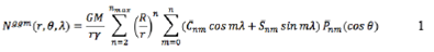
where r, θ, λ are the spherical geocentric coordinates of the computation point: radial distance, co-latitude and longitude, respectively, GM is the gravitational constant (G) times mass (M) of the earth, у is mean normal gravity of the reference ellipsoid, R is the mean earth's equatorial radius, are fully normalized geopotential coefficients with degree n and order m, nm(cos θ) fully normalized associated Legendre functions, and nmax is the maximum degree of the GGM.

In order to determine the optimum GGM for an area's gravity field, geoid heights derived from the GNSS/levelling method could be compared to the geoid heights calculated by GGMs (Amos and Featherstone 2003; Kılıçoğlu et al. 2009; Yilmaz et al. 2010; Hirt 2011; Guimarães et al. 2012). In many GNSS applications users feel a need for transformation between ellipsoidal height and orthometric height. The main reason of this is using orthometric heights in engineering, determined by levelling, and the difficulty of making levelling measurements for each point. Highly precision geoid models are needed for this type of implementation. Geoid height (undulation) values produced based on GNSS/levelling measurements are necessary to determine sensitively to this end (Doganalp and Selvi 2015). According to the GNSS/levelling method, geoid undulation value at a point is calculated with Eq. (2) (Heiskanen and Moritz 1984).

Here N stands for geoid height (undulation), h for ellipsoidal height obtained from GNSS measurements, and H for orthometric height calculated after levelling measurements. To evaluate the quality of GGM-derived geoid undulation values (Nggm) many independent NGNSS/lev values could be used that are spread over the project area. Therefore, absolute geoid height differences AN might be calculated with Eq. (3) (Kotsakis and Sideris 1999; Fotopoulos et al. 2003; Huang and Véronneau 2004; Gikas et al. 2013).

3. Applications

3.1. Study area and data

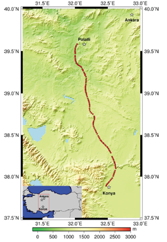
Study field is the High-Speed Train route between Konya-Polatli (Ankara), which is 210 km long. There are 110 GNSS/levelling points (benchmarks) within the project field. Orthometric heights (H) of the points were determined with the geometric levelling method in the datum of the Turkey National Vertical Network (TUDKA). The geographic coordinates including ellipsoidal heights (h) were determined in static positioning mode and referred to the Turkish National Fundamental GPS Network (TUTGA). The orthometric and ellipsoidal height of the points within the study field are varying between 696 - 1198 m and 733 - 1234 m respectively. Also, the geoid heights are varying between 36.72 and 37.70 m (Fig. 1). The minimum, maximum and mean values of distance between sequential points of the route were observed as 1.05, 5.53 and 1.94 km respectively. SRTM-3 data and The Generic Mapping Tools (GMT) software were used to draw Figure 1 (Wessel and Smith 1998). The Shuttle Radar Topography Mission (SRTM) contains elevation data with 3 arc-second resolution and 16 m absolute height error (90 percent confidence level). These data are available with free of charge via the Internet for approximately 80 percent of the earth's land mass (Bildirici et al. 2009).

Fig. 1 Study area, Konya-Polatli express train project  

3.2 Evaluation Procedure

A total of 69 models were used to investigate the quality of GGMs. In order to display the results from those models clearly, GGMs are classified in three models derived from CHAMP, GRACE, and GOCE satellites. Spherical harmonic coefficients of all models were obtained from the International Centre for Global Earth Models (ICGEM) web page. In addition, geoid heights based on GGMs can be calculated using coefficients and software on this website. Within the scope of implementation, in order to include all of Turkey, separate grid networks (grid step is 0.1o x 0.1o) were established for each GGM. GRS80 elipsoid parameters were used to establish grids. A correction needs to be applied on the difference between the true potential of the geoid and the normal potential of GRS80 when calculating geoid height, when using GRS80 as the chosen reference field. The reason for this correction is the difference between the GM value estimated for earth and the GM value for GRS80 elipsoid. Therefore, the "zero-degree" term based on different GM values needs to be considered in geoid height computation (Smith 1998). In addition, while the shape of the geoid depends on the permanent tide system type (mean, zero and tide-free), the values oftrue gravity potential do not change when one system transform another system. Therefore, the tide-free geoid model is suggested to be used in conversion of the GNSS heights (Smith 1998). Thus, correction term (zero degree term) has been applied to all calculations within the context of this application, and tide-free model is used as the tide system. In each of the GGM grid nets established, geoid heights of project points are interpolated using a script.

GGMs based on CHAMP

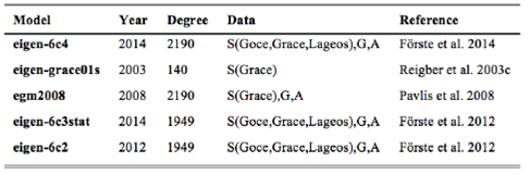
In this section, the results on GGMs for 110 points of the study area produced based on CHAMP are addressed. Totally 17 CHAMP-based global geopotential models are used. Names, production years, degrees and the data used to produce them are given in Table 1. Geoid undulations within study area are estimated using these models. The statistics of the differences between the GNSS-based and the GGM-based geoid undulations are given in Table 2 and Figure 2.

Table 1 Global geopotential models based on CHAMP (S: Satellite, G: Gravity, A: Altimetry) 

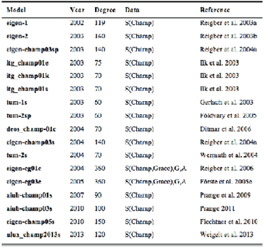
Table 2 Statistics of geoid height differences between GGM-derived (Nggm) and GNSS/levelling (NGNSS/lev) data, units in meters (based on CHAMP) 

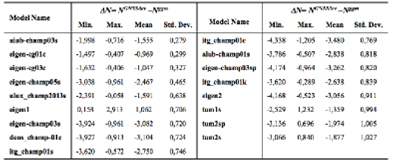
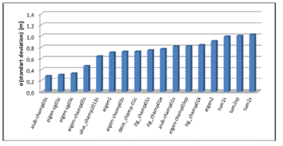
Fig. 2 The standard deviations of geoid undulation differences between GNSS/levelling and GGMs (based on CHAMP) 

Table 2 and Figure 2 show the standard deviation values range between 0.28 - 1.03 m with regard to geoid undulation differences. Moreover, the best five models for CHAMP-based GGMs are aiub-champ03s, eigen-cg01c, eigen-cg03c, eigen-champ05s and ulux_champ2013s, respectively.

GGMs based on GRACE

In this section, 24 global geopotential model evaluations have been done using GRACE-based models. Information on GGMs is given in Table 3. Performance of GGMs determined after evaluation of 110 points within the project field is shown in Table 4. Moreover, the diagram displaying the differences between geoid heights calculated by GGMs and the known heights of GNSS/levelling points is given in Figure 3.

Table 3 Global geopotential models based on GRACE (S: Satellite, G: Gravity, A: Altimetry) 

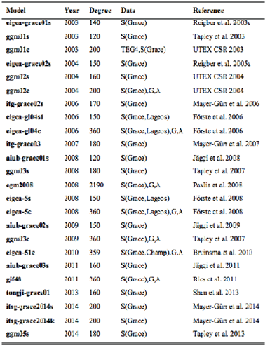
Table 4 Statistics of geoid height differences between GGM-derived (Nggm) and GNSS/levelling (NGNSS/lev) data, units in meters (based on GRACE) 

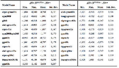
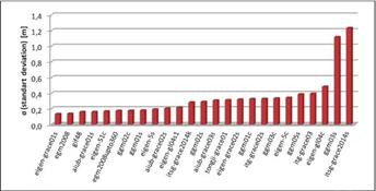
Fig. 3 The standard deviations of geoid undulation differences between GNSS/levelling and GGMs (based on GRACE) 

Table 4 and Figure 3 show the standard deviation values range between 0.13 - 1.24 m according to geoid undulation differences. Lower standard deviation values are reached compared to CHAMP-based models. In addition, the best first five models for GRACE-based GGMs are eigen-grace01s, egm2008, gif48, aiub-grace01s and eigen-51c, respectively.

GGMs based on GOCE

In this section, 28 global geopotential models are evaluated based on the GOCE satellite. Information on GOCE-based GGMs is given in Table 5. Performance of GGMs within the study area is shown in Table 6. Moreover, the diagram displaying the standard deviation of differences between geoid heights calculated by GGMs, and the known heights of GNSS/levelling points is given in Figure 4.

Table 5 Global geopotential models based on GOCE (S: Satellite, G: Gravity, A: Altimetry) 

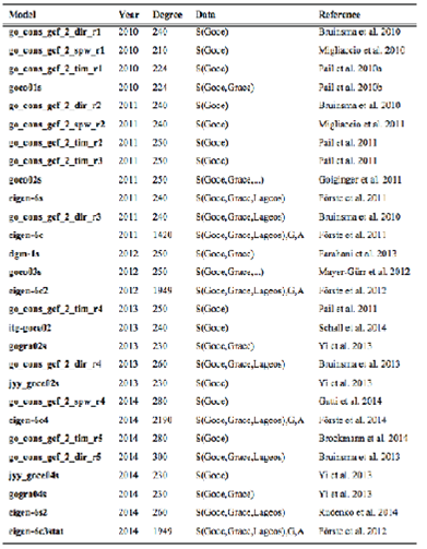
Table 6 Statistics of geoid height differences between GGM-derived (Nggm) and GNSS/levelling (NGNSS/lev) data, units in meters (based on GOCE) 

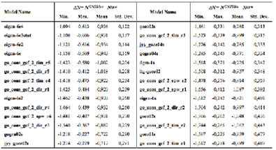
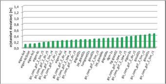
Fig. 4 The standard deviations of geoid undulation differences between GNSS/levelling and GGMs (based on GOCE) 

Table 6 and Figure 4 show the standard deviation values range between 0.12 - 0.49 m with regard to geoid undulation differences. These values might be considered good compared to CHAMP and GRACE-based models. Moreover, the best first five models for GOCE-based GGMs are eigen-6c4, eigen-6c3stat, eigen-6c2, eigen-6c and go_cons_gcf_2_tim_r5, respectively.

Best GGMs in the study area

In order to summarize the results of all the implementations, five GGMs obtained from implementations conducted in three classes are evaluated. Table 7 contains the best five GGMs according to geoid undulation differences within every class. Figure 5 shows the performance of GGMs using the standard deviation values calculated in Table 7.

Table 7 Statistics of geoid height differences between GGM-derived (Nggm) and GNSS/levelling (NGNSS/lev) data, units in meters. 

Fig. 5 The standard deviations of geoid undulation differences between GNSS/levelling and GGMs 

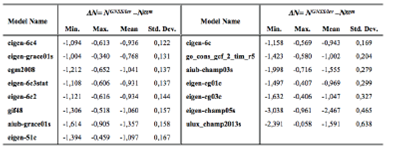
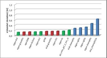
Table 7 and Figure 5 show the best GGM for the study area is eigen-6c4. This model is followed by eigen-grace01s, egm2008, eigen-6c3stat and eigen-6c2, respectively. Considering the performance of these models, there is no large difference between them with regard to standard deviation values. In addition to this, general characteristics of models show that all the models except eigen-grace01s have a considerable degree, and gravity and altimeter data make positive contributions to the model (Table 8).

Table 8 The best five global geopotential models in the study area (S: Satellite, G: Gravity, A: Altimetry) 

Differences between GNSS/levelling-based geoid heights and GGM-based geoid heights are influenced by datum inconsistencies and systematic errors. Therefore, different parametric models could be used in order to minimize these values (bias and tilt) (Kotsakis and Katsambalos 2010; Yilmaz et al. 2010). Generally, three, four, five and seven parametric models are used for the least-squares adjustment of the geoid height differences in the literature. Therefore, these parametric models were tested in this paper.

Geoid Heights Determination using Different Parametric Models

Systematic errors such as datum shifts and distortion among height systems might be minimized using the Least Squares Adjustment (LSA) model. If Eq. (3) is edited with this aim

is obtained (Kotsakis and Sideris 1999; Kiamehr and Sjõberg 2005). Here ai stands for known coefficients vector, x unknown parameters vector, and vi a residual random noise term. Four different parametric models (3, 4, 5 and 7-parameters) are used within the context of application. Mathematical statements for these models are as below, respectively (Kotsakis and Katsambalos 2010).

where xi transformation parameters between two datums, vi residual random noise term, (φi, λi) geodetic coordinates of points, e first eccentricity of the reference elipsoid, and The matrix form is created as follows for the equations

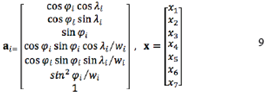
Where ai is the coefficients vector and x is unknown's vector for Model 4. For other parametric models, coefficients and unknowns vector might be formed as in Eq. (9). If the formed coefficients are expanded for each GNSS point, A coefficients matrix (design matrix) would be obtained to be used in LSA (Eq. 10). Afterwards, unknown parameters can be solved with LSA.

Table 9 and Figure 6 show the statistical values obtained with 3, 4, 5, and 7-parameter LSA implementation of the best five GGMs reached as a result of application. Table 9 and Figure 6 also show the best results obtained from the eigen-6c2 model. Moreover, the 7-parameter transformation model gives results that are the most compatible with minimum standard deviation values when compared to other parametric models. Figures 7-11 show the geoid heights after implementing transformation and geoid heights obtained from GGMs with GNSS/levelling geoid heights.

Table 9 Statistics of the differences between geoid heights obtained from GGMs and from GNSS/levelling data after applying the 3-, 4-, 5- and 7-parameter transformation, units in meters 

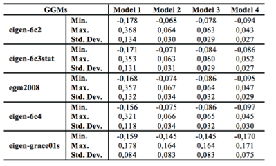
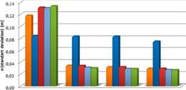
Fig. 6 The standard deviations of geoid undulation differences between GNSS/levelling and GGMs after transformations 

Fig. 7 Undulation values according to eigen-6c2 model 

Fig. 8 Undulation values according to eigen-6c3stat model 

Fig. 9 Undulation values according to egm2008 model 

Fig. 10 Undulation values according to eigen-6c4 model 

Fig. 11 Undulation values according to eigen-grace-01s model 

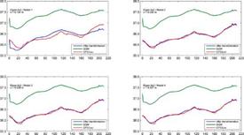
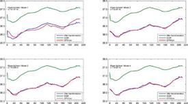
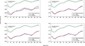
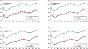
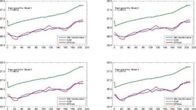
When the Figures 7-11 were examined, it has seen that there were a jump for the first geoid height values calculated from GGMs and the datum shift. The reason for these effects is thought to be systematic errors. Therefore, different parametric models could be used in order to minimize these effects. If the Figures are reviewed, it can be seen that these effects are minimized when the degree of parametric transformation is increased.

The parametric models describing the systematic errors and datum shifts in the different height data sets are used in the study. When the application results and the figures were examined, the 7-parameter transformation model gave results that are the most compatible with minimum standard deviation values when compared to other parametric models. Also, results show that eigen-6c2, eigen-6c3stat, eigen-6c4 and egm2008 global geopotential models produce approximately ±3 cm accuracy when compared to GNSS/levelling. Especially, 7-parameter transformation of eigen-6c2 and eigen-6c3stat models produces geoid height information with ±2.7 cm accuracy for 110 points within this test field. This accuracy obtained from GGMs can be seen adequate for several engineering applications. When the contributions of the new satellites going to be launched in the near future are considered, the accuracies obtained from GGMs will increase with each passing day. Thus, the use of GGMs for determining values such as the geoid height, the height anomaly, the gravity field etc. will play an important role in the earth sciences.

4. Conclusion and Suggestions

The aim of this study is to investigate the performance of GGMs produced by CHAMP, GRACE, and GOCE as well as comparing GGMs with GNSS/levelling data, and eventually to determine the best model. Within the scope of this study, the 210-km long Konya-Ankara high-speed train project was selected in order to investigate GGMs performance. When the study area is examined, it can be stated that the route has a flat ground and there is not a sudden height-change structure. While the orthometric height values of the points in the study area range between 696 and 1198 m, the ellipsoidal height 733 - 1234 m. 110 GNSS/levelling (benchmarks) points were included in the study area. Geoid heights of these points were calculated for all GGMs using only latitude and longitude of the points. Then these values were compared to true geoid heights and the performances of GGMs were examined.

According to results, the standard deviation was obtained as approximately 12 cm after comparing with true values of the geoid heights obtained from the best match GGMs. The best GGMs are obtained eigen-6c4, eigen-grace01s, egm2008, eigen-6c3stat, and eigen-6c2, respectively. High degrees of the GGM of all the models except for eigen-grace01s along with its different data variety (gravity and altimeter) contributed to improving geoid height information obtained from the models.

Systematic errors in GGMs such as datum shifts and distortions can be minimized using different parametric models. Therefore, these errors are minimized using four different parametric (3, 4, 5, and 7-parametric) models in the scope of the implementation. When were examined the results after transformation, 7-parameter model compared to other models were produced the better results. According to 7-parameter model results, the best five GGMs are eigen-6c2, eigen-6c3stat, egm2008, eigen-6c4 and eigen-grace01s. Standard deviation value obtained from GGMs is approximately 3 cm for the first four models and 8 cm for the eigen-grace01s model. Standard deviation value obtained from the eigen-graceOls is significantly higher compared to the other models. This is most probably related to the data, including only satellite observations, and lower degree (n max = 140) of the model.

According to the application results, it may be possible to use 3 cm-geoid height information for various engineering applications. It is obvious that geoid heights obtained from GGMs will be improved through developing technology and new satellite missions to be launched in the near future. It is also possible to conclude that after reaching 1-2 cm geoid height accuracy, height of points will be obtained with high accuracy using GGMs without the need for the levelling process in many engineering applications.

Acknowledgement

The author thanks the Coordinatorship of Necmettin Erbakan University Scientific Research Projects for supporting this work.

References

Amos, M. J., & Featherstone, W. E. (2003). Comparisons of Recent Global Geopotential Models with Terrestrial Gravity Field Data over New Zealand and Australia. Geomatics Research Australasia, 79, 1-20. [ Links ]

Benahmed Dahoa, S. A., Kahlouchea, S., & Fairhead, J.D. (2006). A procedure for modeling the differences between the gravimetric geoid model and GPS/leveling data with an example in the north part of Algeria. Computers & Geosciences, 32, 1733-1745. [ Links ]

Bildirici, I.O., Ustun, A., Selvi, H. Z., Abbak, R. A., & Bugdayci, I. (2009). Assessment of shuttle radar topography mission elevation data based on topographic maps in Turkey. Cartography and Geographic Information Science, 36(1), 95-104. DOI: 10.1559/152304009787340205. [ Links ]

Brockmann, J. M., Zehentner, N., Höck, E., Pail, R., Loth, I., Mayer-Gürr, T., & Schuh, W. D. (2014). EGM_TIM_RL05: An independent geoid with centimeter accuracy purely based on the GOCE mission. Geophysical Research Letters, 41(22), 8089-8099. DOI: 10.1002/2014GL061904. [ Links ]

Bruinsma, S. L., Foerste, C., Abrikosov, O., Marty, J. C., Rio, M. H., Mulet, S., & Bonvalot, S. (2013). The new ESA satellite-only gravity field model via the direct approach. Geophysical Research Letters , 40, 3607-3612. DOI: 10.1002/grl.50716. [ Links ]

Bruinsma, S. L., Marty, J. C., Balmino, G., Biancale, R., Foerste, C., Abrikosov, O., & Neumayer, H. (2010). GOCE Gravity Field Recovery by Means of the Direct Numerical Method. Presented at the ESA Living Planet Symposium, June 27 - July 2, Bergen, Norway. [ Links ]

Ditmar, P., Kuznetsov, V., van Eck van der Sluijs, A. A., Schrama, E., & Klees, R. (2006). 'DEOS_CHAMP-01C_70': a model of the Earth's gravity eld computed from accelerations of the CHAMP satellite. Journal of Geodesy, 79, 586-601. [ Links ]

Doganalp, S., & Selvi, H. Z. (2015). Local geoid determination in strip area projects by using polynomials, least-squares collocation and radial basis functions.Measurement, 73, 429-438. DOI: 10.1016/j.measurement.2015.05.030. [ Links ]

Erol, B., Sideris, M. G., & Celik, R. N. (2009). Comparison of Global Geopotential Models from the CHAMP and GRACE Missions for Regional Geoid Modelling in Turkey. Studia Geophysica et Geodaetica, 53(4), 419-441. [ Links ]

Farahani, H. H., Ditmar, P., Klees, R., Liu, X., Zhao, Q., & Guo, J. (2013). The static gravity field model DGM-1S from GRACE and GOCE data: computation, validation and an analysis of GOCE mission's added value. Journal of Geodesy , 87, 843-867. DOI: 10.1007/s00190-013-0650-3. [ Links ]

Featherstone, W. E. (2002). Expected Contributions of Dedicated Satellite Gravity Field Missions to Regional Geoid Determination with Some Examples from Australia. Journal of Geospatial Engineering, 4(1), 1-19. [ Links ]

Flechtner, F., Dahle, C., Neumayer, K. H., König, R., & Förste, C. (2010). The Release 04 CHAMP and GRACE EIGEN Gravity FieldModels . In: Frank Flechtner, Thomas Gruber, Andreas Güntner, Mioara Mandea, Markus Rothacher, Tilo Schöne & Jens Wickert (Eds.): System Earth via Geodetic-Geophysical Space Techniques, Springer, ISBN 978-3-642- 10227-1. DOI: 978-3-642-10228_8. [ Links ]

Földvary, L., Svehla, D., Gerlach, C., Wermuth, M., Gruber, T., Rummel, R., Rothacher, M., Frommknecht, B., Peters, T., & Steigenberger, P. (2005). Gravity Model TUM-2Sp Based on the Energy Balance Approach and Kinematic CHAMP Orbits. In: Reigber, C., Lühr, H., Schwintzer, P., & Wickert, J. (eds.) Earth Observation with CHAMP, Results from Three Years in Orbit, p. 13-18. Springer, ISBN (Print) 978-3-540-22804-2, ISBN (Online) 978-3-540 26800-0. DOI: 10.1007/3-540-26800_62. [ Links ]

Förste, C., Bruinsma, S. L., Abrikosov, O., Lemoine, J. M., Schaller, T., Götze, H. J., Ebbing, J., Marty, J. C., Flechtner, F., Balmino, G., & Biancale, R. (2014). EIGEN-6C4 The latest combined global gravity field model including GOCE data up to degree and order 2190 of GFZ Potsdam and GRGS Toulouse. Presented at the 5th GOCE User Workshop, Paris. [ Links ]

Förste, C., Bruinsma, S. L., Flechtner, F., Marty, J. C., Lemoine, J. M., Dahle, C., Abrikosov, O., Neumayer, K. H., Biancale, R., Barthelmes, F., & Balmino, G. (2012). A preliminary update of the Direct approach GOCE Processing and a new release of EIGEN-6C. Presented at the AGU Fall Meeting 2012, San Francisco, USA, 3-7 Dec, Abstract No. G31B-0923. [ Links ]

Förste, C., Bruinsma, S. L., Shako, R., Marty, J. C., Flechtner, F., Abrikosov, O., Dahle, C., Lemoine, J. M., Neumayer, K. H., Biancale, R., Barthelmes, F., Kõnig, R., & Balmino, G. (2011). EIGEN-6 - A new combined global gravity field model including GOCE data from the collaboration of GFZ-Potsdam and GRGS-Toulouse. Geophysical Research Abstracts, 13, EGU2011-3242-2, EGU General Assembly. [ Links ]

Förste, C., Flechtner, F., Schmidt, R., König, R., Meyer, U., Stubenvoll, R., Rothacher, M., Barthelmes, F., Neumayer, K. H., Biancale, R., Bruinsma, S. L., & Lemoine, J. M. (2006). A mean global gravity field model from the combination of satellite mission and altimetry/gravimetry surface gravity data. Geophysical Research Abstracts , (8), 03462. [ Links ]

Förste, C., Flechtner, F., Schmidt, R., Meyer, U., Stubenvoll, R., Barthelmes, F., König, R., Neumayer, K. H., Rothacher, M., Reigber, C., Biancale, R., Bruinsma, S., Lemoine, J.M., & Raimondo, J. C. (2005c). A new high resolution global gravity field model derived from combination of GRACE and CHAMP Mission and Altimetry/ Gravimetry Surface Gravity Data. Poster g004_ EGU05-A-04561.pdf presented at EGU General Assembly Vienna, Austria, 24-29, April. [ Links ]

Förste, C., Flechtner, F., Schmidt, R., Stubenvoll, R., Rothacher, M., Kusche, J., Neumayer K. H., Biancale, R., Lemoine, J. M., Barthelmes, F., Bruinsma, S. L., König R., & Meyer, U. (2008) EIGEN-GL05C - A new global combined high-resolution GRACE-based gravity field model of the GFZ-GRGS cooperation. Geophysical Research Abstracts , 10, EGU2008-A-03426, SRef-ID: 1607-7962/gra/EGU2008-A-03426 [ Links ]

Fotopoulos, G., Kotsakis, C., & Sideris, M. G. (2003). How accurately can we determine orthometric height differences from GPS and geoid data? Simulated case studies in Western Canada. J Surv Eng, 129(1), 1-10. [ Links ]

Gatti, A., Reguzzoni, M., Migliaccio, F., & Sanso, F. (2014). Space-wise grids of gravity gradients from GOCE data at nominal satellite altitude. Presented at the 5th GOCE User Workshop, Paris. [ Links ]

Gerlach, C., Földvary, L., Svehla, D., Gruber, T., Wermuth, M., Sneeuw, N., Frommknecht, B., Oberndorfer, H., Peters, T., Rothacher, M., Rummel, R., & Steigenberger, P. (2003). A CHAMP-only gravity field model from kinematic orbits using the energy integral. Geophysical Research Letters , 30(20), 2037, DOI:10.1029/2003GL018025. [ Links ]

Gikas, V., Mpimis, A., & Androulaki, A. (2013). Proposal for Geoid Model Evaluation from GNSS-INS/Leveling Data: Case Study along a Railway Line in Greece. Journal of Surveying Engineering, 139(2), 95. [ Links ]

Godah, W., & Krynski, J. (2013). Comparisions of GGMs based on one year GOCE observations with the EGM08 and terrestrial data over the area of Sudan. International Journal of Applied Earth Observation and Geoinformation, 35, 128-135. DOI: 10.1016/j.jag.2013.11.003. [ Links ]

Goiginger, H., Höck, E., Rieser, D., Mayer-Gürr, T., Maier, A., Krauss, S., Pail, R., Fecher, T., Gruber, T., Brockmann, J. M., Krasbutter, I., Schuh, W. D., Jaggi, A., Prange, L., Hausleitner, W., Baur, O., & Kusche, J. (2011). The combined satellite-only global gravity field model GOCO02S. Presented at the 2011 General Assembly of the European Geosciences Union, Vienna, Austria, 4-8 April. [ Links ]

Guimaraes, G., Matos, A., & Blitzkow, D. (2012). An evaluation of recent GOCE geopotential models in Brazil. Journal of Geodetic Science, 2(2), 144-155, DOI: 10.2478/v10156-011-0033-8. [ Links ]

Heiskanen, W. A., & Moritz, H. (1984). Physical Geodesy, Institute of Physical Geodesy, Technical University Graz, Austria. [ Links ]

Hirt, C. (2011). Assessment of EGM2008 over Germany using accurate quasigeoid heights from vertical deflections, GCG05 and GPS/ levelling. Zeitschrift fuer Geodaesie, Geoinformation und Landmanagement (zfv), 136(3), 138-149. [ Links ]

Hofmann-Wellenhof, B., & Moritz, H. (2005). Physical Geodesy. ISBN-13978-3-211-23584-3. Springer-Verlag Wien. [ Links ]

Huang, J., & Véronneau, M. (2004). Applications of downward continuation in gravimetric geoid modeling - case studies in Western Canada. J. Geod ., 79, 135-145. [ Links ]

Ilk, K. H., Mayer-Gürr, T., & Feuchtinger, M. (2003). Gravity Field Recovery by Analysis of Short Arcs of CHAMP. Proceedings of the 2nd Science Workshop of CHAMP. [ Links ]

Jäggi, A. (2007). Pseudo-Stochastic Orbit Modeling of Low Earth Satellites Using the Global Positioning System. PhD thesis, Institut für Geodasie und Photogrammetrie, Geodatisch-geophysikalische Arbeiten in der Schweiz. vol.73, ISBN:978-3-908440-17-8. [ Links ]

Jäggi, A, Beutler, G., & Mervart, L. (2008). GRACE Gravity Field Determination using the Celestial Mechanics Approach - First Results. Presented at the IAG Symposium on "Gravity, Geoid, and Earth Observation 2008", Chania/Greece. [ Links ]

Jäggi, A., Beutler, G., Meyer, U., Prange, L., Dach, R., & Mervart, L. (2009). AIUB- GRACE02S -- Status of GRACE Gravity Field Recovery using the Celestial Mechanics Approach. Presented at the IAG Scientific Assembly 2009, August 31 - September 4, Buenos Aires, Argentina. [ Links ]

Jäggi, A., Meyer, U., Beutler, G., Prange, L., Dach, R., & Mervart, L. (2011). AIUB- GRACE03S: A static gravity field model computed with simultaneously solved-for time variations from 6 years of GRACE data using the Celestial Mechanics Approach. Paper in preparation. [ Links ]

Janak, J., & Pitonak, M. (2011) Comparison and testing of GOCE global gravity models in Central Europe. Journal of Geodetic Science , 1(4), 333-347. DOI: 10.2478/v10156-011-0010-2. [ Links ]

Kaula, W. (1966). Theory of Satellite Geodesy-Applications of Satellites to Geodesy. Dover Publications, Inc., Mineola, New York. [ Links ]

Kiamehr, R., & Sjöberg, L. E. (2005). Comparison of the Qualities of Recent Global and Local Gravimetric Geoid Models in Iran. Stud. Geophys. Geod ., 49(3), 289-304. [ Links ]

Kılıçoğlu, A., Direnç, A., Simav, M., Lenk, O., Aktuğ, B., & Yildiz, H. (2009). Evaluation of the Earth Gravitational Model 2008 in Turkey. Newton's Bull, Special Issue : " External Quality Evaluation Reports of EGM08 ", 4, 164-171. ISSN: 1810-8555. [ Links ]

Kotsakis, C., Katsambalos, K., Ampatzidis, D., & Gianniou, M. (2008). Evaluation of EGM08 in Greece using GPS and leveling heights. IAG International Symposium on Gravity, Geoid and Earth Observation, Chania, Greece. [ Links ]

Kotsakis, C., Sideris, M. G. (1999). On the adjustment of combined GPS/levelling/geoid networks. J. Geodesy, 73 (8), 412-421. [ Links ]

Mayer-Gürr, T, Eicker, A., & Ilk, K. H. (2006). ITG-GRACE02s: a GRACE gravity field derived from short arcs of the satellite's orbit. Proceedings of the First Symposium of International Gravity Field Service, Istanbul. [ Links ]

Mayer-Gürr, T., Eicker, A., & Ilk, K. H. (2007). ITG-Grace03 Gravity Field Model. http://www.igg.uni-bonn.de/apmg/index.php7id4tg-grace03. [ Links ]

Mayer-Gürr, T., Rieser, D., Höck, E., Brockmann, J. M., Schuh, W. D., Krasbutter, I., Kusche, J., Maier, A., Krauss, S., Hausleitner, W., Baur, O., Jäggi, A., Meyer, U., Prange, L., Pail, R., Fecher, T., & Gruber, T. (2012). The new combined satellite only model GOCO03s. Abstract submitted to GGHS2012, Venice (Poster). http://www.goco.eu/. [ Links ]

Mayer-Gürr, T., Zehentner, N., Klinger, B., & Kvas, A. (2014). ITSG- Grace2014: a new GRACE gravity field release computed in Graz. Presented at the GRACE Science Team Meeting (GSTM), Potsdam. [ Links ]

Migliaccio, F., Reguzzoni, M., Gatti, A., Sanso, F., & Herceg, M. (2011). A GOCE-only global gravity field model by the space- wise approach. Proceedings of the 4th International GOCE User Workshop, 31 March - 1 April, Munich. [ Links ]

Migliaccio, F., Reguzzoni, M., Sanso, F., Tscherning, C. C., & Veicherts, M. (2010). GOCE data analysis: the space-wise approach and the first space-wise gravity field model. Presented at the ESA Living Planet Symposium 2010, Bergen, June 27 - July 2, Norway. [ Links ]

Pail, R., Bruinsma, S. L., Migliaccio, F., Foerste, C., Goiginger, H., Schuh, W. D., Hoeck, E., Reguzzoni, M., Brockmann, J. M., Abrikosov, O., Veicherts, M., Fecher, T., Mayrhofer, R., Krasbutter, I., Sanso, F., & Tscherning, C. C. (2011) First GOCE gravity field models derived by three different approaches. Jounal of Geodesy, 85, 819-843. DOI: 10.1007/s00190-011-0467-x. [ Links ]

Pail, R., Goiginger, H., Mayrhofer, R, Schuh, W., Brockmann, J. M., Krasbutter, I., Hoeck, E., & Fecher, T. (2010a). GOCE gravity field model derived from orbit and gradiometry data applying the time-wise method. Presented at the ESA Living Planet Symposium 2010, Bergen, June 27 - July 2, Norway. [ Links ]

Pail R, Goiginger H, Schuh WD, Hõck E, Brockmann JM, Fecher T, Gruber T, Mayer-Gürr T, Kusche J, Jaggi A, Rieser D (2010b) Combined satellite gravity eld model GOCO01S derived from GOCE and GRACE. Geophysical Research Letters , 37, L20314, doi: 10.1029/2010GL044906. [ Links ]

Pavlis NK, Holmes SA, Kenyon SC, Factor JK (2008) An Earth Gravitational Model to Degree 2160: EGM2008. presented at the 2008 General Assembly of the European Geosciences Union, Vienna, Austria, April 13-18. [ Links ]

Prange L (2011) Global Gravity Field Determination Using the GPS Measurements Made Onboard the Low Earth Orbiting Satellite CHAMP. PhD Thesis, Geodatisch-geophysikalische Arbeiten in der Schweiz, vol. 81. http://www.sgc.ethz.ch/sgc-volumes/sgk-81.pdf. [ Links ]

Prange L, Jaggi A, Beutler G, Dach R, Mervart L (2009) Gravity Field Determination at the AIUB - the Celestial Mechanics Approach. In: Observing our Changing Earth, edited by M. Sideris, Vol. 133, p. 353-362, doi: 10.1007/978-3-540-85426-5_42, Springer ISBN 978-3-540-85425-8. [ Links ]

Reigber C, Balmino G, Schwintzer P, Biancale R, Bode A, Lemoine JM, König R, Loyer S, Neumayer H, Marty JC, Barthelmes F, Perosanz F, Zhu SY (2003a) Global Gravity Field Recovery Using Solely GPS Tracking and Accelerometer Data from CHAMP. Space Science Reviews, 29, p. 55-66. [ Links ]

Reigber C, Jochmann H, Wünsch J, Petrovic S, Schwintzer P, Barthelmes F, Neumayer KH, König R, Förste C, Balmino G, Biancale R, Lemoine JM, Loyer S, Perosanz F (2004a) Earth Gravity Field and Seasonal Variability from CHAMP. In: Reigber, C., Lühr, H., Schwintzer, P., Wickert, J. (eds.), Earth Observation with CHAMP - Results from Three Years in Orbit, Springer, Berlin, p. 25-30. [ Links ]

Reigber C, Schmidt R, Flechtner F, König R, Meyer U, Neumayer KH, Schwintzer P, Zhu SY (2003c) First EIGEN Gravity Field Model based on GRACE Mission Data Only. [ Links ]

Reigber C, Schmidt R, Flechtner F, König R, Meyer U, Neumayer KH, Schwintzer P, Zhu SY (2005a) An Earth gravity eld model complete to degree and order 150 from GRACE: EIGEN- GRACE02S. Journal of Geodynamics 39, p. 1-10. [ Links ]

Reigber C, Schwintzer P, Barthelmes F, König R, Förste C, Balmino G, Biancale R, Lemoine J, Loyer S, Perosanz F, Fayard T (2003) The CHAMP-only Earth gravity eld model EIGEN-2. Adv. Space Res., 31(8):1883-1888. [ Links ]

Reigber C, Schwintzer P, Neumayer KH, Barthelmes F, König R, Förste C, Balmino G, Biancale R, Lemoine JM, Loyer S, Bruinsma SL, Perosanz F, Fayard T (2003b) The CHAMP-only Earth Gravity Field Model EIGEN-2. Advances in Space Research 31(8), p. 1883-1888, doi: 10.1016/S0273-1177(03)00162-5. [ Links ]

Reigber C, Schwintzer P, Stubenvoll R, Schmidt R, Flechtner F, Meyer U, König R, Neumayer KH, Förste C, Barthelmes F, Zhu SY, Balmino G, Biancale R, Lemoine JM, Meixner H, Raimondo JC (2006) A High Resolution Global Gravity Field Model Combining CHAMP and GRACE Satellite Mission and Surface Data: EIGEN-CG01C. Scienti c Technical Report STR06/07, GeoForschungsZentrum Potsdam. [ Links ]

Ries JC, Bettadpur S, Poole S, Richter T (2011) Mean Background Gravity Fields for GRACE Processing; presented at the GRACE Science Team Meeting, Austin, TX, August 8-10. [ Links ]

Rodriguez-Caderot G, Lacy MC, Gil AJ, Blazquez B (2006) Comparing recent geopotential models in Andalusia (Southern Spain). Stud. Geophys. Geod. 50: 619-631. [ Links ]

Rudenko S, Dettmering D, Esselborn S, Schoene T, Foerste C, Lemoine JM, Ablain M, Alexandre D, Neumayer KH (2014) In uence of time variable geopotential models on precise orbits of altimetry satellites, global and regional mean sea level trends. Advances in Space Research, doi: 10.1016/j.asr.2014.03.010. [ Links ]

Rummel R, Balmino G, Johannessen J, Visser P, Woodworth P (2002) Dedicated gravity field missions-principles and aims. Journal of Geodynamics, 33:3-20. [ Links ]

Schall J, Eicker A, Kusche J (2014) The ITG-Goce02 gravity eld model from GOCE orbit and gradiometer data based on the short arc approach. Journal of Geodesy , 88, p. 403-409, doi: 10.1007/s00190-014-0691-2. [ Links ]

Seeber G (2003) Satellite Geodesy. 2nd edition Walter de Gruyter, Berlin Shen Y, Chen Q, Hsu H, Zhang X, Lou L (2013) A modified short arc approach for recovering gravity eld model; presented at the GRACE Science Team Meeting, Austin, TX. [ Links ]

Smith DA (1998) There is no such thing as "The" EGM96 geoid: Subtle points on the use of a global geopotential model. IGeS Bulletin N. 8, International Geoid Service, pp. 17-28, Milan. [ Links ]

Soycan M (2014) Improving EGM2008 by GPS and Leveling Data at Local Scale. Boletim de Ciencias Geodesicas, 20(1), 3-18. [ Links ]

Tapley BD, Bettadpur S, Watkins MM, Reigber C (2004) The gravity recovery and climate experiment: Mission overview and early results. Geophys. Res. Lett., 31(doi: 10.1029/2004GL019920):9607. [ Links ]

Tapley BD, Chambers DP, Bettadpur S, Ries JC (2003) Large scale circulation from the GRACE GGM01 Geoid. Geophysical Research Letters , 30(22), 2163, doi: 10.1029/2003GL018622. [ Links ]

Tapley BD, Flechtner F, Bettadpur S, Watkins MM (2013) The status and future prospect for GRACE after the rst decade. Eos Trans., Fall Meet. Suppl., Abstract G22A-01. [ Links ]

Tapley BD, Ries J, Bettadpur S, Chambers D, Cheng M, Condi F, Poole S (2007) The GGM03 Mean Earth Gravity Model from GRACE. Eos Trans. AGU 88(52), Fall Meet. Suppl., Abstract G42A-03. [ Links ]

Tapley BD, Ries J, Bettadpur S, Chambers D, Cheng M, Condi F, Poole S (2007) The GGM03 Mean Earth Gravity Model from GRACE. Eos Trans. AGU 88(52), Fall Meet. Suppl., Abstract G42A-03. [ Links ]

Ustun A, Demirel H (2006) Long-range geoid testing by GPS-leveling data in Turkey. Journal of Surveying Engineering , 132(1):15-23 UTEX CSR (2004) Center for Space Research, Universityof Texas at Austin, http://www.csr.utexas.edu/grace/gravity UTEX CSR (2003) http://www.csr.utexas.edu/grace/gravity/. [ Links ]

Vaníček P, Featherstone WE (1998) Performance of three types of Stokes's Weigelt kernel in the combined solution for the geoid. Journal of Geodksy, 72, 12, pp. 684-697. [ Links ]

Van Dam T, Jäggi A, Prange L, Tourian MJ, Keller W, Sneeuw N (2013) Time-Variable Gravity Signal in Greenland Revealed by High-Low Satellite-to-Satellite Tracking. Journal of Geophysical Research, Vol. 118, No. 7, p. 3848-3859, doi: 10.1002/jgrb.50283. [ Links ]

Wenzel H (1998) Ultra High Degree Geopotential Models GPM98A and GPM98B to Degree 1800. Proceeding of the Joint Meeting International Gravity Commission, 71-80, Budapest, Finnish Geodetic Institute, Helsinki. [ Links ]

Wermuth M, Svehla D, Földvary L, Gerlach C, Gruber T, Frommknecht B, Peters T, Rothacher M, Rummel R, Steigenberger P (2004) A gravity eld model from two years of CHAMP kinematic orbits using the energy balance approach. presentation at EGU 1st General Assmbly, Nice/France. [ Links ]

Wessel P, Smith WHF (1998) New improved version of Generic Mapping Tools released. EOS Trans. Amer. Geophys. U., 79 (47), pp. 579. [ Links ]

Yi W, Rummel R, Gruber T (2013) Gravity eld contribution analysis of GOCE gravitational gradient components. Studia Geophysica et Geodaetica Vol. 57, No. 2, p. 174-202, ISSN (Online) 1573-1626, doi: 10.1007/s11200-011-1178-8. [ Links ]

Yilmaz I, Yilmaz M, Güllü M, Turgut B (2010) Evaluation of recent global geopotential models based on GPS/levelling data over Afyonkarahisar (Turkey). Scientic Research and Essays Vol. 5(5), pp. 484-493. [ Links ]

How to cite item: Doganalp, S. (2016). An Evaluation of Recent Global Geopotential Models for Strip Area Project in Turkey. Earth Sciences Research Journal, 20(3), C1-C10. doi: http://dx.doi.org/10.15446/esrj.v20n3.55440

Received: January 28, 2016; Accepted: July 01, 2016

Creative Commons License This is an open-access article distributed under the terms of the Creative Commons Attribution License