


 Inglés (pdf)
 Articulo en XML
 Referencias del artículo
 Enviar articulo por email
 Citado por SciELO
  Citado por Google
  Similares en
SciELO
Similares en
SciELO  Similares en Google
 Permalink
1 Introduction
The concept of "eco-water" was introduced by Yang Wunian et al. in 2001, to investigate the impact of water conserved on the earth's surface in forest vegetation on the hydrologic cycle and the local ecological environment (Yang et al., 2001; Wan et al., 2004). Eco-water is water closely related to the earth's surface vegetation and is conserved by the vegetation, the vegetation humus layer and the root soil layer after conversion of the atmospheric precipitation forms the "ecological water layer" centered on vegetation. Eco-water is not directly involved in the hydrological cycle process yet significantly contributes as a buffer and runoff regulator as rainfall is intercepted and groundwater recharged in the eco-water layer.
Eco-water resource levels are difficult to extract and quantify with conventional methods. Quantitative remote sensing inversion theory and algorithm, however, facilitate quantification as developments in high sensitivity remote sensing imaging related to vegetation and soil have occurred in recent years (Li et al., 2009; Jian et al., 2012).
Runoff influence resulting from the vegetation canopy, vegetation humus layer, and the soil layer has consistently presented challenges in hydrological research. Extensive hydrological effect experimentation has followed involving respective sample regions producing substantial runoff information (Liu et al., 1989; Ogee and Brunet, 2002; Rao et al., 2005; Hu et al., 2014). Causative mechanisms from the influence of vegetation canopy, vegetation humus layer and soil layer on runoff are exhibited independently, yet interaction effectiveness is the same-conserving water, buffering and adjusting flow. The eco-water layer then utilizes the three combined as an "independent converter" in the hydrologic cycle. The capability of converting eco-water quantitatively, as expressed by the remote sensing quantitative retrieval method, simplifies water resource quantification while concurrently contributing to increased practicality for determining the influence of eco-water on runoff.
2 Eco-water remote sensing quantitative retrieval
2.1 Study area and data
Upper Minjiang River Basin, located in the transition region from eastern Qinghai-Tibet Plateau to Sichuan Basin, is an essential tributary to the Upper Yangtze River and also a vital water conservation area for the Chengdu Plain. Vegetation of the upper Minjiang River has been referred to as the "natural barrier and green reservoir of the land of abundance", but due to massive deforestation for hundreds of years, deterioration of this ecological environment has created severe reductions in water conservation capacity as forest vegetation has decreased and lead to reduction in dry season runoff.
The relation between spectral data and biochemical parameters of vegetation and soil should be determined respectively for the MEC modeling. Different plants and soil specimens were collected and biochemical parameters then measured. The water content of vegetation and soil was computed from the biochemical parameters, while the spectral data was acquired with Field Spec Pro FR, the full spectrum portable spectrometer ofASD (Analytical Spectral Devices).
LANDSAT5 TM images were utilized in this study with the product type referred to as "L1T", provides systematic radiometric and geometric accuracy by incorporating group control points while employing a DEM (Digital Elevation Model) for topographic accuracy. The study area consists of three scenes; the ranks numbers are 13037, 13038 and 13039. Preprocessing is required before quantitative image retrieval: mosaic, subset, radiation calibration and atmospheric correction. Image quality and imaging time for eco-water remote sensing quantitative retrieval are critical factors for accuracy. Cloud, snow, and fog appearance in images will, for example, significantly interfere with the ecological water quantitative inversion if not controlled within 10%. Consistent seasons should be compared to the amount of eco-water resources in different years as vegetation and precipitation vary among seasons producing large differences in vegetation and soil water content. Images for MEC retrieval were acquired on June 26, 1994, and on June 13, 2001, in this study. Two phase images are with high quality and similar imaging time that makes inversion results more accurate and comparable.
2.2 Modulus of eco-water conservation modeling
The amount of water conserved by the eco-water layer was represented by the Modulus of Eco-water Conservation (MEC), an integral parameter of ecological water. MEC is related to vegetation and soil water content and represents the water conservation ability of the earth's surface based on vegetation. Remote sensing technology with high sensitivity and accessibility allowed to extract the vegetation and soil information. Thus quantification of each was a precondition for calculating MEC. The basic research unit of remote sensing image digital processing is a single pixel with MEC following by also utilizing a single pixel as the primary research unit. According to the definition of MEC that the MEC model of pixel is as follows:

Where EWTc(i,j) is vegetation water content of the pixel(i,j), W(T)(i,j) is soil water content of the pixel(i,j).
If there are M lines and N rows of the remote sensing image of the study area, the amount of ecological water resource is:

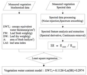
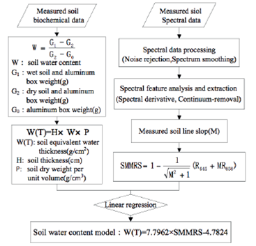
The principle of remote sensing quantitative inversion is the reflection spectrums of surface features exhibit particular characteristics (Zhang et al., 2010). Vegetation water content has an obvious response to spectral characteristics in the wavelength range from near infrared to intermediate infrared. 1600nm indicates a high moisture absorption band while 820nm indicates a weak moisture absorption band, allowing the vegetation index SR (Simple Ratio) established by the ratio effectively to highlight the vegetation water content information (Zhang et al., 2010; Wang et al., 2011; Yi et al., 2012). The modeling process of vegetation water content is demonstrated in Figure 1. Advantages and disadvantages of soil moisture estimation models with optical sensor differ, and after analyzing the characteristics and regression effects with actual soil water content measurement, SMMRS (Soil Moisture Monitoring by Remote Sensing) based on soil line was chosen. This is a straight line in a two-dimensional spectral space of red and near infrared generated from a series of pure soil pixels ranged by reflectance. The line is a comprehensive reflection of the soil's characteristic in various water conditions (Zhan et al., 2007; Qin et al., 2012). The modeling process of soil water content is demonstrated in Figure 2.
2.3 Results of eco-water remote sensing quantitative retrieval
SR is the ratio of infrared wavelengths (center wavelength of 1676 nm) and nearly red band (center wavelength of 840 nm) in remote sensing image inversion of EWTc. The soil line of the image must be derived initially to compute SMMRS for the remote sensing image reversal of W(T). The Modulus of Eco-water Conservation of the study area was then retrieved according to the MEC model based on the already retrieved EWTc and W(T). Ecological water-related parameters inversion results are displayed in Table 1.
3 The influence analysis of eco-water on runoff
3.1 Change trend of runoff and climate
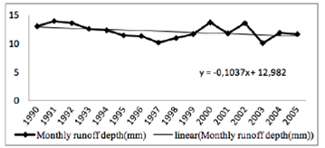
Weather conditions during the same period should also be considered when studying the influence of ecological water on runoff. Climate data collected for this study was related to precipitation and temperature of year and month in the Upper Minjiang River Basin between 1990 and 2005. Precipitation and temperature data were collected from 9 national surface meteorological stations (Songpan, Zoige, Barkam, Hongyuan, Xiaojin, Dujiangyan, Pingwu, Mianyang, Ya'an) which were within or adjacent to the river basin and then was interpolated to derive raster data of the study area. Runoff data of year and month in the Upper Minjiang River Basin between 1990 and 2005 was collected from Zipingpu hydrologic stations. According to the data analysis results, during the period 1990-2005 in Upper Minjiang River Basin, the annual runoff depth, and the annual precipitation both revealed a decreasing trend (Figure 3); annual average temperature was on the rise (Figure 4); minimum monthly average depth in dry season appeared nearly consistent in February; and February monthly runoff depth exhibited a decreasing trend (Figure 5).
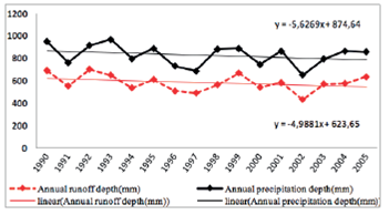
Figure 3 Annual precipitation and runoff depth change trend between 1990 and 2005 of Upper Minjiang River Basin
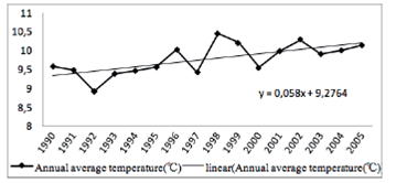
Figure 4 Annual average temperature change trend of between 1990 and 2005 of Upper Minjiang River Basin
3.2 Variation of eco-water
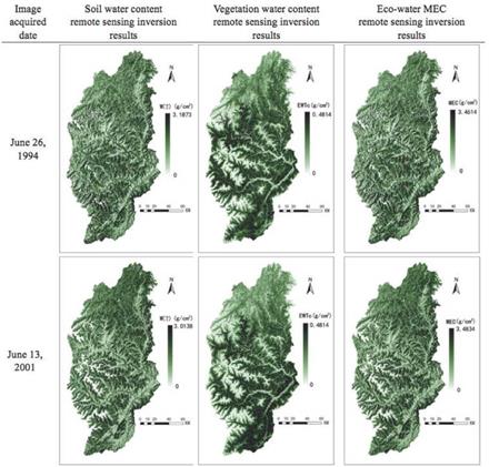
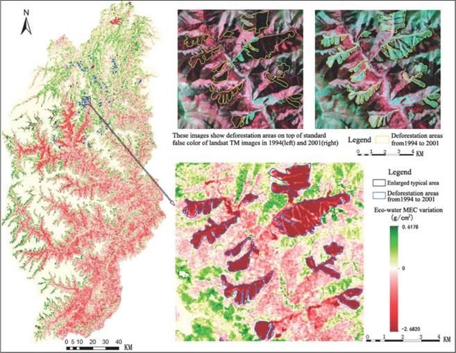
Two phases of MEC were retrieved with quantitative remote sensing method. The mean of MEC in 1994 was 1.6206 g/cm2, converted to a depth of 16.206 mm. in 2001 was 1.4635 g/cm2, converted to a depth of 14.635 mm. The depth of eco-water was 1.6mm less in 2001 than in 1994; thus water conservation capability decreased in 2001 from 1994 levels. Subtraction of the two phases of MEC may reveal the change in eco-water levels, extent and spatial distribution of recovery or degradation, and the impact of eco-water on runoff.
A high ratio overlap of the MEC maximum reduction area and the deforestation area occurred (Figure 6), revealing that deforestation likely resulted in a reduction of water conservation capability in the basin. Various levels of MEC reduction took place in the lower altitude valley area, with slight increases in the relatively smooth terrain areas of Songpan and Heishui counties. The MEC changes closely correlated to the vegetation level with reduction of MEC due to vegetation degradation resulting from both natural and human factors. Temperature rise and decreasing precipitation caused aridification of the river valley, leading to vegetation degradation (Wu et al., 2003), while deforestation and overgrazing generated the same result (Sansom, 1999). Measures for plant protection and restoration were implemented to achieve an increase in MEC as deforestation have been prohibited since 1999 and farmland has been converted back to forests or grasslands with mitigative forest planting continuously and actively promoted. Recovery of MEC remains much less than a reduction, as the MEC recovery area was significantly less than the reduction area with the greatest degree of improvement at 0.6178 g/ cm2, much less than the most significant reduction level of 2.6820 g/cm2.
3.3 The influence analysis of eco-water on runoff
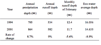
A comparison of mean MEC with annual precipitation depth, annual runoff depth and runoff depth in the dry season was conducted to determine the eco-water influence on runoff. The effect of eco-water on runoff is displayed more clearly by water recharging abilities in the dry season as the formation of flood peak is so closely aligned with precipitation. Influence of eco-water on runoff focuses on exploring water recharging capability for a runoff in the dry season in this study.
Comparing the data from the year 2001 with the year 1994 (Table 2), the annual precipitation depth had increased by 8.7% and the annual runoff depth had increased by 9%, but the runoff depth in dry season had decreased by 5.6%, indicating transformation of precipitation directly into surface runoff increased, while intercepted and conserved precipitation fell. The mean of MEC depth had dropped8.9%, explaining the reduction in water conservation capacity of the basin. Comparing the two phases for the depth of runoff and eco-water reveals the vital influence of eco-water on runoff as when the amount of eco-water was reduced, the water supply capacity of eco-water to flow in dry season also decreased.
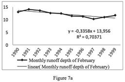
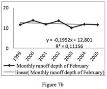
Eco-water is a vegetation-centered water resource that decreases with vegetation destruction and increases with vegetation restoration. The year 1999 was a turning point for vegetation change in the Upper Minjiang River Basin as deforestation practices were prohibited and implementation of plant protection measures followed. The changing trend is illustrated as eco-water was monitored between 1990 and 2005, first decreasing until 1999 and then slightly increasing. Change direction of February runoff depth during the same period was analyzed and found to exhibit an obvious decreasing trend between 1990 and 1999 as the correlation coefficient R2 reached 0.7037 (Figure 7a). The declining trend was weakened between 1999 and 2005 as the correlation coefficient R2 was only 0.1116 and the decreasing slope increased from -0.3358 to -0.1952 (Figure 7b). The trend change comparison further proved that eco-water exerted significant influence on runoff in the Upper Minjiang River Basin. Trends demonstrated a pattern showing that when the amount of eco-water decreased, eco-water water recharge capability to a runoff in dry season also decreased, while under eco-water recovery conditions, water recharge capability also exhibited a degree of recovery.
4 Conclusion and Prospect
(1) As a product of vegetation canopy, vegetation humus layer, and the soil layer, eco-water may be assumed to be independent of the hydrologic cycle, allowing the study of water storage and recharge capability from the three sources to be systematic and quantitative and simplifying the study of the related hydrological effects.
(2) Eco-water is related to vegetation at the earth's surface. Thus changes of eco-water resource amounts are closely related to vegetation alterations. Deforestation is central to decreases in the supply of eco-water resources making plant protection and restoration for the eco-water layer protection and restoration crucial.
(3) The comparison of change revealed that eco-water exerted influence on runoff in the Upper Minjiang River Basin. A vast supply of eco-water increased capability of water recharge for a runoff in the dry season and a decreasing eco-water supply weakened the capacity.
Eco-water is integral to the hydrological cycle in determining the allocation of water resources. Water resources will attain a dynamic and natural balance in well-developed eco-water areas; however, when the eco-water layer suffers damage, precipitation will begin to transform into surface runoff directly and instantaneously, contributing to an imbalanced setting off flooding, droughts, and ecological deterioration. Further research may produce sufficient eco-water data retrieved over time to be analyzed with precipitation and temperature for specifying more accurate effect and action mechanisms of eco-water on runoff and for contributing to improved flood and drought management.

