


 English (pdf)
 Article in xml format
 Article references
 Send this article by e-mail
 Cited by SciELO
  Cited by Google
  Similars in
SciELO
Similars in
SciELO  Similars in Google
 Permalink
Analysis of groundwater chemical characteristics is an essential content of hydrogeology subject. It will be of important significance to both use and management of region groundwater resources and construction and protection of ecological environment (Zhang, Deng, & He, 2006). Chemical characteristics of the groundwater are determined by sedimentary environment and sedimentary association characteristics of provenance. It is also subject to the interaction of natural and human factors such as flood, saline intrusion, ecologic water conveyance and agricultural irrigation (An, Zhao, Ye, Liu & Ding, 2012). Through study on groundwater chemical characteristics, the scientific basis will be provided for interaction mechanism of groundwater and environment, description of groundwater recharge, runoff and discharge conditions, as well as groundwater resources management.
In recent twenty years, for rapid economic and social development and climate changes in Zhumadian City, the conflict between water resources supply and demand in the urban area of Zhumadian City increase prominently. The urban area of Zhumadian City is located at the slight area of the mountain front, where surface water resources are deficient and limited surface water resources are not enough to meet the increasing water resources demand, and groundwater plays a vital role in development and use of water resources (Liu, Zhang, & Ren, 2002). Study on chemical characteristics of shallow groundwater in the urban area of Zhumadian City is conductive to understand further of typical features of current shallow groundwater in the area. Moreover, it can provide scientific bases and management concept for groundwater use in this area, and it is good to safeguard sustainable development of water resources. Also, it is of great theoretical guidance significance and practical value of reasonable use and protection of groundwater resources in the urban area of Chinese cities.
1.1 Physical Geography
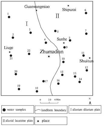
The study area is located Zhumadian City, Henan Province, with geographical coordinates of east longitude 113°56'02"~114°08'52" and northern latitude 32°54'29"~33°04'31". The total area is 360 km2, and the number of population is 570400. The study area is a relatively gentle terrain and ground slope gradient of 1~10 %o. Bounded by Guanwang Temple, Shun River, and Li Tower, its western part is alluvial-proluvial plain, and its eastern part is alluvial-lacustrine plain, as shown in Figure 1. The earth surface is composed of hard and dense silty clay of the Middle Pleistocene and slight yellow muddy clay limnetic facies of upper Pleistocene. It is in the transition zone from northern subtropics to warm temperate zone and belongs to a mainland monsoon type climate, with primary weather features of prominent monsoon climate, four distinctive seasons, moderate climate, the same season of rain and hot, multi-year mean evaporation capacity of 935.5mm and multi-year mean precipitation of 966.0mm. The water system is not well developed in the study area, in addition to a few of streams, only a relatively large Lianjiang River passes the area from the south boundary. Lianjiang River is a branch of Ru River and flows into Suya Lake Reservoir from west to east through the urban area.
1.2 Geology and Hydrogeology
Shallow groundwater in the urban area of Zhumadian City mainly lies in silty, clayey soil porosity of Quaternary Pleistocene series. Aquifer group structure is single-layer clayed soil structure. Water storage capacity of shallow groundwater is different in different parts of the study area. Quaternary Pleistocene series lithology in this area is thick-layer brownish yellow, auburn yellow, yellowish-brown and ginger silty clay with muddy medium-coarse sand, muddy medium-fine sand, fine muddy silt and muddy gravel layer. Silty clay porosity and fracture from earth surface to the layer 30m deep are well developed and connected and constitute a storage space of shallow groundwater.
A supply source of shallow groundwater in the urban area of Zhumadian City is mainly from atmospheric precipitation, following lateral groundwater flow and well irrigation area infiltration. Shallow groundwater flows from west to east, without obvious depression cone. The drainage mainly includes industrial and agricultural exploitation, evaporation and lateral flow.
2 Data and Methods
2.1 Data
Twenty-two sampling wells were arranged in the study area, as shown in Figure 1, with a radius of 0.25-0.50m and depth of 15-60m to reveal the chemical characteristics and spatial distribution characteristics of shallow groundwater in the urban area of Zhumadian City. The analysis items of groundwater quality mainly include bicarbonate ion, carbonate ion, free carbon dioxide, calcium ion, magnesium ion, potassium-sodium ion, chloride, sulfate, ammonia nitrogen, total hardness, total dissolved solids, pH value, microelement, metal ion, conductivity, total acidity and total alkalinity.
2.2 Methods
This paper studies water chemistry of groundwater and its spatial distribution characteristics in the urban area of Zhumadian City using graphical method (Zhang et al., 2006; An et al., 2012; Lu, Zhou, Wang, Yang, & Lu, 2010), hydrogeochemistry simulation (Tang, Chen & Qian, 2012; Jiang, Li, & Hu, 2009; Li, Hou, Zhou, & Liu, 2009) and other methods.
3 Results and Discussion
3.1 Spatial Distribution Characteristics of Water Chemistry Composition
3.1.1 Spatial Distribution Characteristics of TDS and Hardness
Under the usual state of many water chemical properties, TDS can reflect the overall condition of chemical composition field, and total hardness is an important indicator of water quality and significantly affects industrial water (Zhang & Shen, 2000). Based on the results of chemical analysis of water samples in the study area, contour map of TDS of shallow groundwater in the urban area of Zhumadian City (Fig. 2) and contour map of total hardness (by CaCO3) (Fig.3) are drawn as below.
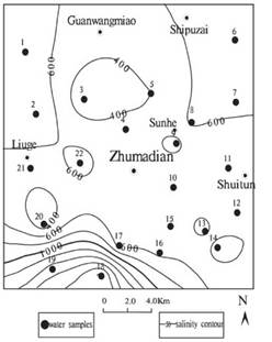
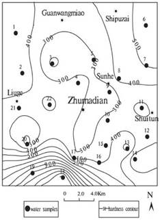
It can be learned from the analysis as below. (1) According to TDS level, groundwater can be classified into fresh water (TDS<1g /L), brackish water (1g /L<TDS<3g /L) and salt water (TDS>3g /L). Shallow groundwater in the urban area of Zhumadian City is mainly fresh water, with brackish water in southwestern part and no salt water. TDS becomes lower from southwest to northeast, and it changes rapidly in the southwest part, but changes slowly in other regions. Based on water quality monitoring data, TDS of Well 18 and 19 is relatively high, contents of Cl- and SO4 2- ions at these two points are far superior to that of other monitoring points and may be affected by pollution. (2) According to hardness classification standard (by CaCO3), groundwater can also be classified into soft water (<150mg/L), little hard water (50-300mg/L), hard water (300-450mg/L) and very hard water (>450mg/L). Hard water and very hard water mainly distribute around the urban area, and groundwater is of relatively small hardness in the center area. Based on features of the city, groundwater around urban area of Zhumadian City is relatively high and may be polluted by urban domestic water, industrial water, and other wastewater. (3) Based on Figure 2 and Figure 3, TDS and Salinity of the southwest part of the urban area of Zhumadian City are both relatively high, which less likely result from natural causes. By access to information, it is found that there is a quarrying transport factory at Xiangshan Town at the southwest part of the urban area of Zhumadian City, and there are power plants and coal mines in Gucheng Town, so it is speculated that such human activities result in pollution of local groundwater.
3.1.2 Spatial Distribution Characteristics of Hydrochemical Type
Piper trilinear chart of shallow groundwater (Figure 4) is drawn, and graphical method is applied to analyze and study hydrochemical characteristics and its spatial distribution rule of shallow groundwater in the study area.
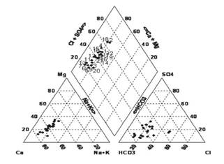
From the figure, it can be drawn as below. (1) Water sampling points in the study area are mainly distributed at the left bottom of the delta-shaped region, indicating groundwater in the study area is primarily of HCO3-Ca type, or HCO3-CaMg, SO4-CaMg and SO4-Ca type. (2) Hydrochemical types of the study area from southwest to northeast are transiting from HCO3-Ca to HCO3-CaMg, SO4-CaMg and SO4-Ca- and spatial variation degree of the anion is higher than that of positive ion. (3) Carbonate hardness of water sample point is greater than 50%, indicating that chemical composition of water is mainly of carbonate lixiviation. Besides, groundwater is dominated by HCO3 -with little mineralization degree and also reflecting that shallow groundwater in the urban area of Zhumadian City is mainly from atmospheric precipitation.
3.2 Ion Proportionality Coefficient Characteristics
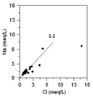
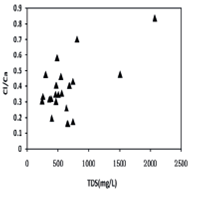
In chemical composition of groundwater, content proportionality coefficient among all compositions is often used to study some hydrogeochemical problems and judge the groundwater causes, groundwater composition source and groundwater classification Li, Sun, & Liu, 2000). Coefficient YNa/YCl and YCl/YCa are respectively used to reflect the causes and hydrodynamics of shallow groundwater in the study area Jiang et al., 2009.
(1) YNa/YCl coefficient is called as groundwater cause coefficient and is a hydrogeochemical parameter of sodium ion concentration degree of natural groundwater. The mean value of YNa/YCL coefficient of standard saline water is 0.85; low salinity water has relatively high YNa/YCl coefficient (YNa/YCl>0.85) and high salinity water has relatively small YNa/YCl coefficient (YNa/YCl<0.85).
From Figure 5, it can be drawn that analysis point of shallow groundwater sample in the urban area of Zhumudian City is at or close to line 1:1. It indicates that groundwater will continuously dissolve rock minerals by the hydrolysis and acidification action in the runoff process and release Na+ from feldspar so as to make Na+ concentration larger than Cl- concentration. It also indicates that groundwater has a rock-salt lixiviation action in the runoff process. Sampling Well 18 is abnormally large due to Cl- milliequivalent and YNa/YCl coefficient is relatively small, which reflects southwestern part of the study area may be polluted.
(2) YCl/YCa coefficient can be used as a parameter describing hydrodynamics. From Figure 6, it can be drawn that when TDS<1000mg/L, YCl/YCa coefficient does not change significantly with TDS. However, when TDS>1000mg/L, YCl/YCa coefficient increases sharply. It shows that northeast part of the study area is a relatively good hydrodynamic condition and southeast part is a relatively weak hydrodynamic condition. At the same time, there are two significant deviations sampling points, well 18 and 19, which also reflects that they are most likely polluted.
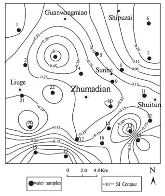
3.3 Saturation Index Analysis
Saturation index refers to the parameter which is used to determine the status of water and minerals through getting water-rock interaction information, represented by "SI." When SI>0, minerals in water are saturated and will subside; when SI<0, minerals in water are unsaturated and will be dissolved; when SI=0, minerals in water are in an equilibrium state of dissolution and sediment, that is, the minerals will not subside and also not be dissolved (Li et al, 2009).
PHREEQC software is used to simulate and calculate saturation index of mineral facies of shallow groundwater in the study area to quantitatively describe evolution state of the chemical field of shallow groundwater. Because shallow groundwater is mainly of HCO3-Ca type, calcite saturation index is selected to draw a contour map of mineral saturation index to analyze hydrochemical characteristics of groundwater in the study area.
From calcite SI contour map (Fig.7), it can be drawn as below. (1) Calcite mineral SI in the study area mostly is less than 0, and the fields with an SI larger than 0 are mainly at southwest, southeast and northeast part of the study area, reflecting the study area is dominated by calcite dissolution. However, at the southwest, southeast and northeast part of the study area, calcite sediment is separated out. (2) Mineral saturation index may be affected by groundwater circulation and exchange degree. Calcite saturation indexes at the southwest, southeast and northeast part of the study area are larger than that of other regions, and that of the southwest part is the largest. It reflects runoff condition at such sections is relatively worse than that of other areas, water circulation and exchange are relatively slow, and mineral saturation index is relatively high, especially water circulation and exchange in southwestern part are the weakest. (3) Parts with relatively high mineral saturation index are around the urban area, similar to hardness distribution rule. Based on the study area including large urban, living and industrial activity strength and shallow groundwater, groundwater chemistry is more easily affected by human endeavor, reflecting that shallow groundwater in the urban area of Zhumadian City is significantly affected by human activity.
4. Conclusion
Based on spatial distribution characteristics, ion proportionality coefficient and saturation index analysis results of chemical composition of water in the study area, conclusion can be drawn as below: (1) Shallow groundwater in the urban area of Zhumadian City is mainly of HCO3-Ca type, salinity, and hardness decrease from southwest to northeast and hydrodynamic conditions become worse from northeast to southwest. (2) Intensive human activities occur in the study area, which may significantly affect groundwater, and the groundwater at the southwest part of the study area is likely polluted.

