


 English (pdf)
 Article in xml format
 Article references
 Send this article by e-mail
 Cited by SciELO
  Cited by Google
  Similars in
SciELO
Similars in
SciELO  Similars in Google
 Permalink
Introduction
The lead-zinc-barium deposits of the Benue Trough have been known since colonial times. Initial exploration efforts mainly by geologists from the Geological Survey of Nigeria (GSN) between the late 1930's and the early 80's led to the discovery of some small to medium-sized deposits in a fairly extensive belt stretching from the southeastern part of the Trough to the northeastern parts. Tattam 1930 made the earliest report on lead-zinc-barite mineralization in the Lower Benue Trough, highlighting the mode of occurrence and mineralogy of the lead-zinc deposits in the Abakaliki area. This was followed by extensive surveys to determine the extent of mineralization in the Abakaliki and Ishiagu areas, (McConnel, 1949; Mc Kay, 1950; Farrington, 1952; Orajaka, 1965). Nwachukwu (1974) determined the temperature of formation of the Abakaliki deposits from fluid inclusion studies and suggested a magmatic origin for the deposits. The origin based on circulating connate waters proposed by Olade (1976) was supported by fluid inclusion studies and trace element geochemistry (Olade and Morton, 1985).
Ezepue (1984) described the geologic setting of the lead-zinc deposits around Ishiagu, with emphasis on how tectonic fissures influenced the loci of mineralization. Lead isotope (Maurin and Lancelot, 1987) and geophysical studies (Etim et al., 1988) suggested that the most credible lead source for the Abakaliki mineralization corresponds to detrital feldspars which were eroded from the basement and re-concentrated within the sandstone-shale series. The latter supported this claim from 48 electric soundings with correlation from 2 well logs within the vicinity. The results of this survey revealed the presence of a sandstone formation probably more than 300m thick at the core of the NE-SW anticlinal structure and the absence of an evaporitic sequence or salt dome up to the depth of 275m.
Akande et al. (1988, 1989) used a combination of field evidence, ore microscopy, electron microprobe, fluid inclusion and stable isotope studies on the lead-zinc deposits of the Middle and Lower Benue Trough, and suggested a basinal-brine expulsion model for the Benue ore fluids. The distribution of the lead-zinc-barium deposits in the Benue Trough of Nigeria are restricted to the Albian - Turonian sediments but more widely distributed spatially. They occur along the entire stretch of the basin, but as secluded and widely separated bodies.
Sediment-hosted lead-zinc-barium deposits can be of the Sedimentary Exhalative (Sedex), also known as clastic-rock dominated sedimentary sequences (Leach et al., 2010) or of the carbonate-dominated sequences also known as the Mississippi Valley Type (MVT). The most important characteristics of these two main deposit types are found in Gustafson and Williams (1981), Large (1983), Sangster (1990), Lydon (1996), Sangster and Hillary (1998) and Leach et al. (2005).
The general characteristics of the Benue Trough lead-zinc-barium deposits, therefore, are: (1) the ores are epigenetic. (2) They are hosted in carbonaceous shales and siltstones of Albian - Turonian age. (3) They are closely associated (spatially) with igneous intrusions. (4) Ores occur as veins which may extend up to 2km in length. (5) Veins are structurally controlled, and trend NW-SE and N-S. (6) The temperature of ore formation from fluid inclusion studies is between 90oC and 200oC. (7) They are closely associated with saline springs. (8) The principal mode of occurrence is open space filling (rather than replacement). (9) Wall rock alteration is minimal or non-existent, suggesting that temperature of mineralizing fluid was low and (10). The ores are localized in a variety of widely separated rocks, which implies that ore formation is related to regional rather than local processes.
In the present work, four mineralized areas were identified and studied in greater detail. These include: (1) the Ishiagu area; (2) the Abakaliki area; (3) the Wanikande-Wanakom area; (4) the Gabu - Oshina area. This paper presents the results of lithologic and structural studies carried out around quarry sites and mining pits in these four mineralized areas.
Regional geologic setting
The Benue Trough is a major sedimentary basin in Africa, stretching over 1000 km in length, with a width ranging between 150 and 250 km. It is part of the Cretaceous West African Rift System (WARS, Fig. 1), which can be traced along a distance of about 4000km from Nigeria, running northwards into the neighboring Republic of Niger and terminates in Libya (Binks and Fairhead, 1992).
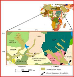
Figure 1 Location of the Benue Trough in the West African Rift System (WARS) and Central African Rift System (CARS) (Modified from Binks and Fairhead, 1992).
Geographically, the trough is divided into three regions, from southwest to northeast; the Lower, Middle and Upper Benue Trough, which correspond to different geologic features (Maurin et.al, 1986; Benkhelil, 1989; Rebelle, 1990).
In the Lower Benue Trough, basin formation was as a result of at least two tectonic phases. The first tectonic phase was assigned Aptian -Santonian by Short and Stauble (1967) and Albian - Santonian by Murat (1970). Simpson (1954) recorded that the sediments of the Abakaliki-Benue Trough underwent a minor folding phase during the Cenomanian and a major one accompanied by igneous intrusions during the Santonian. The folding has an NE-SW trend, plunging southeastwards and allowing the younger formations to overstep into the older beds. A second tectonic phase formed the Anambra Basin and Afikpo Syncline (Santonian -Maastrichtian). The down-faulting of the Anambra platform to form the Anambra Basin, and the down warping in the east to create the Afikpo Syncline coincide with the structural deformation of the Abakaliki-Benue Trough.
The sedimentary fills of the basins in the study area were controlled by cycles of transgressions and regressions and local tectonics. The transgressive phases were characterized by deposition of shales with shoal carbonates developed on submerged structural highs (platforms, horsts). The regressive phases were characterized by extensive deltaic sediments and by predominantly fine clastics (shallow marine shales) deposited over the structural highs. Three cycles of basin fill have been recorded in the Lower Benue Trough: the Neocomian - Cenomanian Asu-River Group, the Early to Late Turonian Eze-Aku Group and the Coniacian - Santonian Awgu Group.
The first cycle was deposited during the Aptian - Cenomanian. The Asu River Group was described as the initial clastic fill of the lower Benue Trough (Petters and Ekweozor, 1982). It occupies the core of the Abakaliki anticlinorium and consists of about 3,000m thick basal arkosic sandstones (Awi and Mamfe Formations of Aptian - Albian age) and middle marine shales sandstones (Awe Formation of Early Cenomanian to Early Turonian age).
The Gboko Formation has been described as the oldest lithologic unit in the lower Benue Trough, (Reyment, 1965; Ramanathan and Nair, 1984). The Gboko Formation rests directly on the Precambrian granitic basement, which had been dated 539 Ma old (Umeji and Caen-Vachette, 1983). The general sequence of this formation from the oldest to the youngest units has been described by Umeji (2000) as consisting of a basal sandstone-siltstone unit with limestone bands overlain by alternations of limestone with siltstone-shale units. The environment of deposition ranges from hyposaline to marginal hypersaline lagoon (Ramanathan and Nair, 1984). In the Abakaliki-Ogoja region, the sediments were subdivided into the Middle Albian sandy unit at the base (Ekebeligwe Formation), the shaly upper unit of Late Albian age (Abakaliki Shale) and the Early Cenomanian Ibir and Agala Sandstones (Ojoh, 1992).
Overlying the Asu-River Group is the Turonian Eze-Aku Group which consists of fossiliferous calcareous sandstones, shales, and limestones. Occasionally, thick sandstone or limestone units alternate with the calcareous shales. Sediments of this age have been mapped along the entire Benue Trough and are noted as the most extensive marine sedimentation deposited when the Mediterranean or Tethys Sea linked up with the Atlantic across the Sahara. This marine sedimentation probably started during the late Cenomanian and continued into the Early Turonian without a break.
The main shale unit in this group has its type locality at the Eze-Aku River, near Aka-Eze in the southern part of the basin. It has been observed that in this section the Cenomanian continues up the stratigraphic sequence without a break into the Turonian, (Ojoh, 1992). Thick sequences of alternating pyritic, black, calcareous shales and limestones in Isinkpume, Ezillo, and Nkalagu areas were described as Nkalagu Formation (Petters, 1978). Northeast-southwest trending sandstone ridges in the Amasiri and Ugep areas were described as Amasiri Formation within the Eze-Aku Group. The sandstone ridges are 20-30m thick and up to 20m higher than the surroundings (Banerjee, 1980). These sandstones which are commonly bioturbated grade from fine and wave-rippled at the base to coarse, pebbly and trough cross-bedded at the top. The rippled basal part had been described as offshore mud and sand deposit whereas the trough cross-bedded upper part was regarded as tidal and subtidal bars (Banerjee, 1980). The Cenomanian to Lower Turonian sediments were estimated to be 2,100m thick (Cratchley and Jones, 1965).
The overlying Awgu Group (Coniacian - Santonian) consists of the grey-blue Awgu-Ndeaboh Shale and the medium to coarse-grained bioturbated Agbani sandstone. Large scale cross-stratification and herringbone cross-bedding are common primary sedimentary structures in the Agbani sandstone. Reyment (1965) considered the Agbani sandstone as a time-equivalent of the Awgu shale. Conversely, Cratchley and Jones (1965) thought that it is a later deposit of thick sandstone beds which accompanied the shallowing of the Coniacian Sea. Cratchley and Jones (1965) also thought that the sandstone beds of the Agbani sandstone appeared to herald the period of uplift, renewed folding and intense local erosion, which is assigned to the Santonian sub-stage because of the absence of fossiliferous materials of Santonian age. The Awgu Shale is estimated to be about 900m thick (Benkhelil, 1986).
The Santonian represented a period of tectonic and igneous activity, when the sediments of the Abakaliki - Benue Trough were folded, uplifted and intruded by igneous rocks, leading to low-grade metamorphism in some cases (Ojoh, 1992). The sediments of the Benue Trough were eroded and variously overstepped by the Campanian and Maastrichtian beds of the Anambra Basin. The horst and graben structure in the Calabar Flank were initiated at this time (Whiteman, 1982; Reijers, 1996).
Characteristics of the ore deposits
The Ishiagu mineralization
The Ishiagu lead-zinc deposits are located in the southwestern tip of the Abakaliki anticlinorium (Fig. 2). The deposits are hosted in Albian sediments which have been folded during the Santonian, producing numerous anticlinal and synclinal features. The anticlines are transected by several northwesterly and northerly trending tensional faults and fractures. Around the Ishiagu area, lead-zinc deposits are hosted mainly by shales of the Asu-River Group and occasionally in sandstone facies of the group
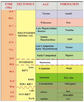
Figure 2 Stratigraphic succession of southeastern Nigerian sedimentary basins (modified from Nwajide, 1990).
The shales are dark gray, finely laminated, carbonaceous and in places hard and splintery due to effects of burial. Some exposed sections contain beds of laminated, medium to coarse grained poorly sorted sandstones which represent sandstone facies of the Asu-River Group. The overlying Turonian sediments belonging to the Eze-Aku Group are exposed both to the north and south of the underlying shales. They consist of both sandstone and shale members. The sandstone units exposed mainly to the north (Fig. 4) are pinkish, but weathered and ferruginized in some places; they are fine - medium grained, moderately to poorly sorted and highly indurated sandstone units with a general ENE-WSW strike and dips of 25o - 40o to the NW and SE. The shale units are exposed mainly to the south, and are generally dark gray, carbonaceous, thinly bedded, flaggy and fissile on weathering. They strike between NE-SW to ENE-WSW trends with dips of 30o - 40o NW and SE.
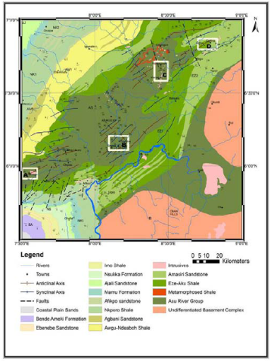
Figure 3 Geologic map of the study area showing positions of mineralized areas (white frames). A: Ishiagu Area; B: Abakaliki Area; C: Wanikande-Wanakom Area; D: Gabu-Oshina Area.
Igneous bodies around the Ishiagu area are mainly intrusive and hyperbysal rocks, whereas volcanic rocks are minor and relatively less extensive. The results of petrographic studies indicate that the rocks are mostly of doleritic to dioritic compositions characterized by vein and cavity fillings of calcite. The Crush Rock Quarry at Ngwogwa exposed a large section of these bodies (Fig. 5b) emplaced concordantly to the bedding planes of the host pelitic rocks, indicating that they are sills. Adjacent to the quarry, dioritic rocks occur as large boulders (diameter 2 -5m) and forms a slightly elevated hill. The dioritic rocks are characterized by zoned plagioclase of andesine composition in a sub-ophitic relationship with augite (Fig. 5c). The doleritic rocks are fine - medium grained with similar mineralogic composition with the diorites.
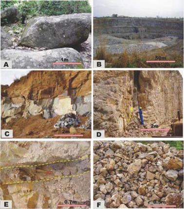
Figure 5 (A) Boulders of dioritic rocks at Ugwu Chime. (B) A section of the Crush Rock quarry at Ngwogwa Ishiagu exposing thick sills of doleritic to dioritic rocks beneath an overburden of approximately 3m. (C) View of doleritic sills in Ngwogwa. (D) NW-SE trending fracture (shown by the direction of the arrow) on the shale-mudrock sequence in an abandoned lead-zinc quarry at Ugwutangela. (E) The lead-zinc vein in sandstone at Green Field mine (broken line shows the width of vein approx. 35cm). (F) Galena and sphalerite ready for market.
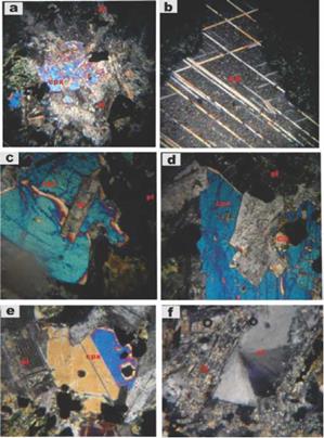
Figure 6 Photomicrographs of doleritic and dioritic rocks around the Ishiagu area (X-Nicols x25). (a) Phenocryst of clinopyroxene (cpx) surrounded by groundmass of plagioclase (pl) in diorite. (b) Well developed crystal of calcite (ca) showing rhombohedral cleavage in dolerite. (c) Clinopyroxene (cpx) and plagioclase (pl) in a sub-ophitic relationship in dolerite. (d) Large crystals of clinopyroxene (cpx) in intersertal relationship with plagioclase (pl) and calcite (ca) in dolerite. (e) Zoned clinopyroxenes in diorites. (f) Stilbite (St) exhibiting a typical bow tie form in dolerite.
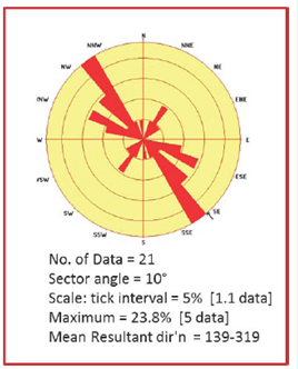
The imprints of the Santonian event in this area are characterized by both ductile and brittle deformation. These features may have controlled the emplacement of the lead-zinc deposits, which is observed to be restricted to NW-SE and N-S trending fractures. A rose diagram (Fig. 7) of field measurements for fracture orientations taken from both the intrusives and Albian sediments shows a predominance of NW-SE trends and minor NE-SW trends. Crosscutting relationships suggest that the NE-SW fractures predate the NW-SE fractures. The NE-SW fractures are generally barren and are more extensive than the NW-SE fractures. It is observed that the mineralized NW-SE fractures consist of a series of closely spaced, steeply dipping sub-parallel features, typically forming en-echelon patterns (Ezepue, 1984; Benkhelil, 1986).
The Ishiagu mineralization consists principally of lead-zinc in the ratio of approximately 2:1, barite is conspicuously absent. Other vein constituents include pyrite, siderite, chalcopyrite, marcasite, bornite, and quartz. The veins are generally 0.25 - 5m wide and 20 - 150m long. Wall rock alteration is either absent or minimal, suggesting a low temperature for mineralizing fluids.
The Abakaliki mineralization
The Abakaliki mineralization consists of a series of fracture filling sub-parallel en-echelon mineralized lodes occurring around Enyigba, Ameri, Ameka, and Ndiagu areas. They appear to be the largest and most extensive of the mineralized areas within the study area, in addition to possessing a long history of mining. Between 1905 and 1909, the lead-zinc mineralization was already known and investigated by the Mineral Survey of Southern Nigeria. By the period from 1925 - 1929 the output in the Abakaliki area increased but declined rapidly around 1937 due to a global fall in price. Mining activity picked up in the 1950's with the establishment of the Nigerian Lead-Zinc Mining Company. In recent times exploration and mining have been restricted to the activities of artisanal miners and a few indigenous mining companies.
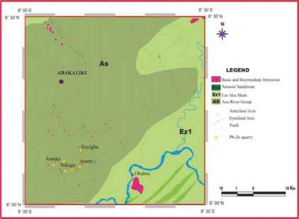
Sedimentary infilling comprises of Albian to Coniacian formations which include the Asu-River Group and the Eze-Aku Group. The Asu-River Group in this area is composed mainly of dark carbonaceous shales, which appear baked in some places accompanied by a mixture of mudstone and shale (Fig. 9a, b). Some sections include thin beds of highly indurated siltstone which have undergone both ductile and brittle deformation (Fig. 9c). The Turonian Eze-Aku Formation is exposed within 2-3kms southeast of the main mineralization centers in the study area and is composed of dark gray carbonaceous shales which grade further south into a series of highly indurated feldspathic sandstones. The sandstone bodies form a set of sub-parallel approximately ENE-WSW trending ridges which stand out relative to the more easily eroded shale intercalations.
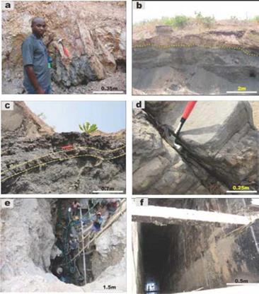
Figure 9 (a) Mudstone facies in association with dark gray shale around Enyigba. (b) Dotted lines show contact between mudrock and shale. (c) Folded beds of highly indurated siltstone intercalations with shale. (d) Well-jointed basaltic exposures around Obubra. (e) lead-zinc artisanal mine pit in Enyigba. (f) Abandoned mine shaft at Ameri.
The absence of igneous bodies in the vicinity of the mineralized area is peculiar only to the Abakaliki area. The closest igneous body outcrops around Obubra, about 10km southeast of the deposit and is composed of basaltic bodies, exposed by the Cross River. Around Abakaliki town (approximately 30km north of the mineralized area) a number of volcanic and intrusive rocks consisting mainly of pyroclastics form small reliefs corresponding to a heterogeneous group.
Benkhelil (1986) has given a detailed account of structural features associated with the Abakaliki mineralization. Like the Ishiagu area, mineralization here is also related to NW-SE and N-S trending fractures which are transected in some places by N-S trending sinistral faults. The fractures are less conspicuous than those around Ishiagu; however, it is clear that like in the Ishiagu area, the mineralization follows the trend of the dominant fracture trend.
The Abakaliki mineralization is considered the largest in the study area based on the size and density of lodes. The Enyigba lode, for example, has been traced for almost 2km and can be up to 30m wide. The ore assemblage consists mainly of galena, sphalerite, siderite, chalcopyrite, pyrite, bornite, and quartz. Like in the Ishiagu case, barite is conspicuously absent. Field evidence, ore microscopy, and electron microprobe analyses of the lodes suggest that the vein mineralization commenced with pre-ore precipitation of diagenetic marcasite, pyrite, and minor gel-like colloform textured schalenblende and galena particularly in the vein - wall contacts (Akande and Mucke, 1993).
The Wanikande-Wanakom Mineralization
The Wanikande-Wanakom barium-lead-zinc mineralization is not well known. The area is best known as a magmatic center (Benkhelil, 1986; Obiora, 2002). Detailed work carried out by Benkhelil (1986) around the area focused on tectonic features. Obiora, (2002) concentrated on the detailed description of the composition and general disposition of the igneous bodies found in the area. Between 2005 and 2008, increased local demand for barite led to the opening of some mining pits/quarries in this area. This development facilitated the gathering of field data for this study.
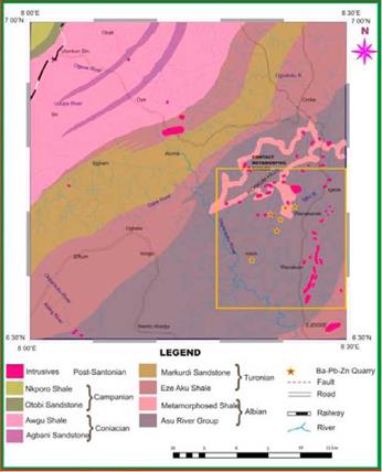
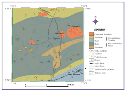
Figure 10 The Geologic map showing the positions of barium-lead-zinc quarries around the Wanikande-Wanakom area. Yellow frame illustrates the extent of mineralization.
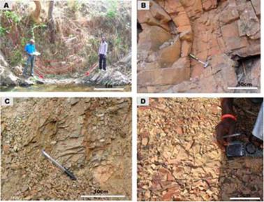
Figure 11 (A) Synclinal fold of shales of the Asu-River Group around Ameka, about 3km north of Wanikande. (B) Folded unit of mudstones around Wanihem. (C) View of baked shales of the Asu-River Group. (D) Well-jointed baked shale of the Asu-River Group exposed in a road cut along Wanikande-Wanakom road.
Igneous bodies in the Wanikande-Wanakom area include dioritic rocks, micrograbbros, nepheline syenites, dolerites, basaltic sills, nephelinites, trachytes, and pyroclastics. The diorites occur as boulders, are mesocratic, course grained with the interlocking mineral arrangement. The light colored minerals are dominantly plagioclase of andesine composition and may include sodalite, and nepheline. Prismatic lensoid hornblende and subordinate short, pyroxenes are also a major part of the essential mineral constituents, whereas biotite, apatite, sphene and opaques occur as accessories. The syenites are commonly nepheline syenites, and are leucocratic, medium to coarse grained, and form large plutons.
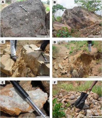
Figure 12 (A) Boulder of pyroclastics on the Wanudu hills containing large xenoliths of lithic fragments. (B) An outcrop of dioritic rock along the Wanikande-Wanakom road. (C) Exposure of nepheline syenite around an abandoned barite mine at Wanikande. (D) Abandoned barite mine at Wanikande. (E) A sample of barite mined from syenites. (F) Samples of low-grade barites around abandoned quarry at Wanikande.
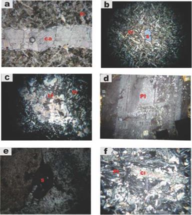
Figure 13 Photomicrographs of igneous rocks around Wanikande. (X-nicols x25) (a) Calcite veinlet in alkali basalts. Observe the distinct rhombohedral cleavages in the Calcite (Ca). (b) Phenocryst of Sodalite (S) in a groundmass of predominantly plagioclase (Pl). (c) Lithic fragments (LF) in pyroclastics, tiny laths of plagioclase (Pl) are observed. (d) Large grain of plagioclase (Pl) of oligoclase composition found in syenites. (e) Euhedral grain of sodalite (S) in syenite. (f) Disoriented crystals of plagioclase (Pl) in alkali trachyte. Chlorite (Cl) may have resulted as an alteration product of feldspars.
At the Uganga hill, nepheline syenite exposures are quite extensive and host the barite veins around the area. Obiora (2002) described the nepheline syenite body as having an oblate shape and aligned in an essentially N-S orientation with dimensions of 3.5 x 2.0 km. The body exhibits a compositional zonation from the center towards the periphery. The core consists of a kaersutite-hastingsite bearing rock with abundant alkali feldspar and diopside. The presence of clinopyroxene, hastingsite, with or without paragsite, characterizes the intermediate zone, while only clinopyroxene with minor arfvedsonite were noted in the periphery.
A leucocratic, medium-grained rock suspected to be nephelinite was also encountered around Uganga hill. The outcrop is extensive and of about 100m long and 10m wide. The rock is composed predominantly of feldspathoidal minerals with appreciable feldspars and subordinate hornblende, biotite, and pyroxene. Under thin section, the rock exhibits trachytic texture. Over 20 outcrops of pyroclastics clustering around the Wanadu Hills were encountered, they consist of vent-tuffs and lapilli tuffs, agglomerates, and breccias, with widespread occurrence of lithic fragments which constitute shales and fossils.
The prominent structural features of this area include tight folding, fracturing, and crenulation cleavage. Benkhelil (1986) reported the existence of a set of large scale faults in this area. The faults are a combination of dip slip and strike slip faults, and are well displayed because they are oblique to the bedding planes; they are often mineralized with quartz and have traces of slickenside striations along the walls. A series of tight anticlinal/synclinal features were observed (Fig. 11A) with fold axes approximately oriented in the E-W direction. The fractures manifest mainly as tensional joints and are more prominent in the igneous rocks than the sediments. Hundreds of joint orientations were taken from the shales and the different igneous bodies in the area and the data plotted on rose diagrams (Fig. 14).
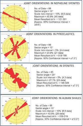
Figure 14 Rose diagram showing the dominant trends ofjoints in the Albian shales and some of the intrusive rocks around the Wanikande-Wanakom area.
The rose plots show that the dominant trend for joints in the syenites and the nepheline syenites is NW-SE. In the syenites, out of the 85 data samples plotted, 23 of them plotted in the NW-SE direction, 18 plotted in the NNW-SSE direction and 9 in the NNE-SSW direction. In the nepheline syenites, the WNW-ESE trend predominates containing about 45 data out of the 98 data plotted. The pyroclastics and the Albian shales contain predominantly NE-SW fractures. For the pyroclastics, 21 data out of the 88 plotted were in the NE-SW direction followed closely by 19 in the NNW-SSE direction, while for the Albian shales 29 out of the 66 data plotted in the NE-SW direction. Field relationships show that the NW-SE/ NNW-SSW fracture trends are younger than the NE-SW trends. Most of the NW-SE fractures are filled with barite and less commonly, lead-zinc ores, and their predominance in the intrusive rocks suggests that they are probably Post-Santonian in age.
Mineralization in the Wanikande-Wanakom area represents a marked deviation from the Ishiagu and Abakaliki mineralizations. Barite appears and predominates in most of the veins studied. It is observed that the barium:lead:zinc ratio increases northwards from 2:2:1 near Adum (Wanakom) to 100% barite at the Wanudu hills (Wanikande). The mineralized veins seem to be interwoven with the igneous bodies and in some places are hosted by the igneous bodies, generally having a width of between 5cm - 200cm and length of between 2m - 30m. The intimate relationship between the veins and the igneous bodies presents an enormous exploitation challenge to artisanal miners, consequently, at the time of fieldwork (2010), the mines were all abandoned.
The Gabu-Oshina Mineralization
The Gabu-Oshina mineralization occurs approximately 25km NNW of Ogoja town. Like the Wanikande-Wanakom area, this area is relatively unknown from literature; however, it possesses great potential for barium-lead-zinc mineralization. Over the past eight years, a number of medium to large veins (mainly barite) were discovered in this area, making it one of the most mineralized areas in the entire study area. The activities of a mining company, Emo-Ashapura, which is involved in semi-mechanized open cast barite mining in the area since 2008, led to the discovery of other veins in the area.
The Gabu-Oshina area consists mainly of Turonian sediments deformed along northeasterly trending axes producing numerous gentle folds. The lithostratigraphic units include highly indurated sandstones, shales, and mudstones of the Eze-Aku Group. The shales are exposed mainly along stream channels; they are dark, highly fissile and sometimes flaky with dips of 30o - 40o (S or SSE). The sandstones comprise of highly indurated poorly sorted, laminated arkosic units, which sometimes display a fining upward sequence. The sandstone bodies are also tilted with strikes of N30oE - N60oE and dips of 20o - 30o to the southwest. Around the barite quarry at Oshina, dips greater than 50o were observed on the sandstones. Some of the barite quarries expose small bodies of basaltic - doleritic sills. The sills are usually thin (0.4m - 2m), consequently they do not constitute any serious barrier to mining activities.
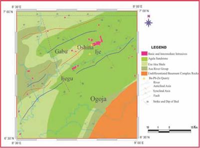
Figure 15 Geological map of Ogoja Sheet showing the location of barite-lead-zinc quarries in the Gabu-Oshina area.
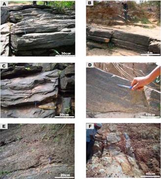
Figure 16 (A, B, C) Fractured and highly indurated Turonian Sandstones observed around the Gabu - Oshina area. (D) Planar lamination in highly indurated sandstone. (E) Shale beds exposed in a valley around Otukpo in the Gabu-Oshina area. (F) Highly tilted beds exposed adjacent the Oshina mining pits.
Structural features within the area are restricted to gentle folds and randomly oriented fractures. The folds are reflected by tilting of the beds, although the dips can be high (30o - 60o), the wavelengths of the folds are naturally long (kilometric) and so unlike in the areas around the Workum Hills, where the profile of tight folds can be traced on outcrop scale, the folds in the Gabu area manifest from opposite dips over long distances. Fracture orientations were taken mainly from sandstones around the barite quarries. The readings were plotted on a rose diagram (fig 18) which reveals that the dominant trend is oriented in the ENE-WSW direction and accounts for about 14% of the data plotted. NW-SE, NNE-SSW, and N-S trends are prominent and are related closely and intimately to each other. Cross-cutting relationships suggest that the N150oE (NW-SE) fractures predate the N80oE (ENE-WSW) fractures. Although the N80oE joints are more in number, they are conspicuously barren of barium-lead-zinc minerals relative to the N150oE fractures which are mineralized.
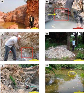
Figure 17 (A) Abandoned barite mine pit at Oshina. (B) Nodules of barite and galena found in old mine pits at Gabu. (C) Barite vein in weathered sandstones. (D) Heaps of mined barite crystals ready for market. (E) Artisanal miners in one of the mining pits around Gabu. (F) Salt Pond at Gabu, at approximately 50m from a mine pit. The yellow circle indicates the position of seepage.
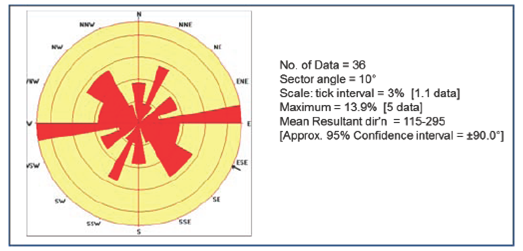
Figure 18 Rose diagram showing the dominant trends of fractures in the sandstones and shales around the Gabu-Oshina barium-lead-zinc quarries.
The Gabu-Oshina barium-lead-zinc mineralization consists of an array of closely related veins arranged en-echelon along an approximately NE-SW direction. The mineralized veins are predominantly oriented in the NW-SE and N-S directions and extend for up to 1.5 km in length. The width of the veins ranges from a few centimeters to tens of meters and are composed predominantly of barite. Galena and sphalerite are rare forming minor constituents of the mineralization and are conspicuously absent in some of the principal lodes.
Discussion
The distribution of existing lead-zinc-barium mineralized locations around the study area (Fig. 3), do not show any definite trend (at least locally) however, an approximate NE-SW trend which coincides with the main axis of the basin can be assumed on a regional scale. Associated host rocks include Albian Shales belonging to the Asu-River Group which are baked in some places, Turonian sandstones and shales belonging to the Eze-Aku Group and Post-Turonian to Coniacian intrusives ranging from diorites, syenites, nepheline syenites, which are of highly variable composition. These suggest that the mineralization is devoid of any major lithologic affinity.
The deposits are associated at least spatially with igneous bodies and saline springs. The absence of igneous bodies in the vicinity of the quarries around Enyigba-Ameri-Ameka and of saline springs around the Wanakom-Wanakonde area is highly notable. Due to the widespread distribution of intrusive rocks exposed in the study area, the authors are of the opinion that the observed close spatial association between mineralized veins and intermediate to mafic intrusive rocks in the study area does not have genetic implication. Furthermore, it is evident from field observations that the intrusives predate the mineralization. In the Wanakonde area, barite-dominated veinlets are seen cross-cutting late Cenomanian to Santonian intrusives.
It is clear from field evidence that the mineralization is structurally controlled. Without exception, mineralization appears to be restricted to parallel or sub-parallel en-echelon NW-SE trending fractures. This trend, although subordinate to the dominant NE-SW trend observed in most locations, is prominent and appears younger than the more dominant trend.
Mineralized veins range from a few centimeters to tens of meters in width and from a few meters to over 2km in length. The broad variation in size and geometry is more because of the non-restriction of the veins to a lithologic type than it is to spatial location. Ore assemblage varies from one location to the other; there is a marked dominance of galena and sphalerite in the southern parts of the study area with barite conspicuously absent. Barite appears around Wanakom and continues to increase in dominance northwards. Also, the southern deposits are more polymetallic in composition, including such minerals as galena, sphalerite, pyrite, siderite, chalcopyrite, marcasite, bornite, and quartz. Except for galena and sphalerite, all other ores occur only in minute quantities.
Although the Benue Trough lead-zinc-barium deposits may be considered a clastic rock dominated lead-zinc-barium deposit, they lack the essential characteristics of SEDEX deposits and hence do not fit properly into any of Leach et al.'s (2005) grouping of sediment-hosted lead-zinc deposit. The suggestion by Olade and Morton (1985) from mineralization features, that the Benue Trough lead-zinc deposits be assigned a distinct category (riftogenic) is considered inappropriate for the following reasons. (1) The term riftogenic derived from "rift" has a genetically tectonic affiliation and falls under the category of deposits (MVT) formed in continental rift tectonic setting described by Leach et al. (2010). (2) There are insufficient data on sulfur, Lead and oxygen isotopes to precisely characterize the deposits and compare with other classical lead-zinc-barium deposits in other parts of the globe.
The association of the well-known lead-zinc deposits in the Lower Benue Trough around Ishiagu and Enyigba with barites around Wanakom, Wanikande and Gabu-Oshina is well established. The observation that the ores co-exist in the same veins around Wanakom suggests that they belong to the same metallogenic province and epoch. It is also interesting to note the variation in ore composition from predominantly lead-zinc deposits in the south to lead-zinc-barium in the middle and predominantly Barium in Gabu-Oshina (northern part of the study area).
Conclusion
The Benue Trough of Nigeria is host to numerous lead-zinc-barium veins trending in predominantly NW-SE trends. Mineralization appears to be associated at least spatially with igneous intrusions and saline springs. The widespread occurrence of intrusive igneous rocks of varying mineralogical composition in the Lower Benue Trough coupled with observed crosscutting relationships with the mineralized veins and absence of igneous bodies in the vicinity of lead-zinc quarries around Enyigba suggest that the deposits are not genetically related to the intrusions. Host rocks range from shales, siltstones, sandstones, and intrusives hence there is no distinct lithologic affinity. The ore assemblage varies remarkably from the southwestern to the northeastern part of the study area, with lead:zinc:barium ratios ranging from approximately 3:1:0 at Ishiagu, to 2:1:0 at Enyigba, 1:0:2 at Wanikande and nearly 100% barite at Gabu-Oshina. The ore deposits have been characterized to fit roughly into the base metal type mineralization known as clastic-rock dominated lead-zinc-barium deposits.

