


 Inglês (pdf)
 Artigo em XML
 Referências do artigo
 Enviar este artigo por email
 Citado por SciELO
  Citado por Google
  Similares em
SciELO
Similares em
SciELO  Similares em Google
 Permalink
Introduction
Asteroid and comet impacts have played a major role in the geological history of the Earth. It is widely proposed that the Chicxulub impact event, 65 million years ago (Alvarez, 1980) and the Wilkes Lands impact event in Antarctica, 320 million years ago (von Freseet al., 2009), could have perturbed the global environment so catastrophically that major life extinction could occurr by these comic impacts. Therefore, both the scientific community and the general public are increasingly interested in both the threat to civilization and the potential environmental consequences of impacts. This study is based on model simulation offered by The Earth impact effect program (Collins et al., 2005) to estimate the severity of several of these environmental effects, which focuses on the consequences of an impact event for the regional environment; that is, from the impact location or ground cero to a few hundred kilometers away. The purpose of this paper is to model the asteroid impact effects that could be registered in the geological record of the Vichada structure and surrounds to guide a fieldwork searching for evidences of thermal radiation, seismic shaking, and air blast and ejecta effects that could confirm the probable asteroid impact origin of the Vichada Structure and to classify it as a proven asteroid crater. Previous papers have examined, in detail, the geomorphological and satellite, airborne and ground gravity and magnetic evidences of the probable Vichada impact crater (Hernandez et al., 2009, 2011).
The Vichada Impact Crater structure
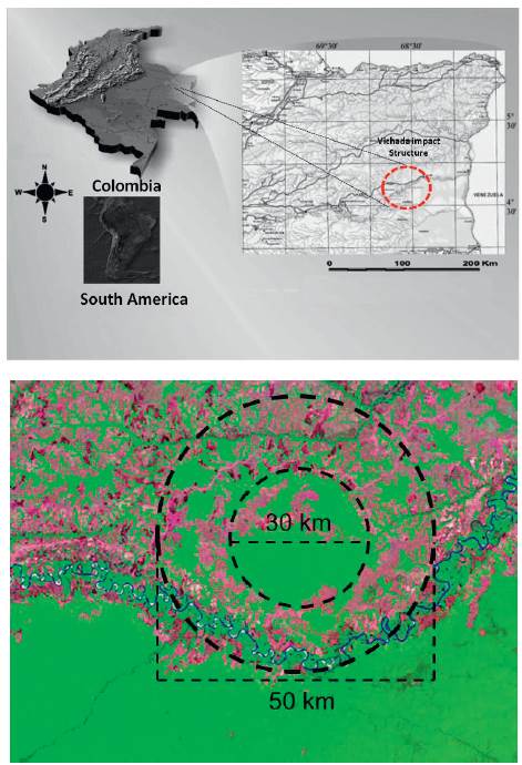
The Vichada Structure is a probable asteroid impact structure along the Vichada River in Colombia (4°30׳N69°15׳W, Vichada Department, Colombia, South America; figure 1). It is most likely the largest probable impact structure in South America. The structure was discovered by Rocca (2004) by examining TM Landsat imagery. The structure consists of a central flat depression surrounded by two concentric rings of hills of approximately 30 and 50 km diameter, respectively. The Vichada River anomalously flows around the outer ring of small hills. The structure has the typical multi-ring shape configuration of large impact structures: A central peak ring impact structure. The central core consists of a ring about 30 km. in diameter which surrounds a central depression of circular shape and 20 km. in diameter. In this innermost region, there is a basin, the relief is quite smooth and it is the deepest part of the structure. The central basin is covered by jungle and it is surrounded by 2 concentric rings of low hills. The outer most ring is 50 km in diameter and in the Vichada River flows around it in a perfect semi-circle following the external limits of this outer ring of hills. This flow around feature of the river is very interesting and anomalous. The geology of the area is not known in very detail. Rocks exposed in the Rio Vichada structure include Precambrian metasedimentary and granitic rocks with an extensive sedimentary cover. The sedimentary cover is composed by a heterogeneous sequence of conglomerates, sandstones and claystones. The Oligocene to Pliocene covering strata lie on top of Precambrian crystalline basement rocks. This circular structure is probably older than 30 million years. A combined satellite and airborne gravity and magnetic study were carried out over the 50 km wide structure (Hernandez et al., 2009).As a result, a prominent positive free-air gravity anomaly mapped over a roughly 50-km diameter basin is consistent with a mascon centered on (4°30'N, -69°15'W) in the Vichada Department. Follow up, ground-based gravity and magnetic anomalies were modeled confirming the regional free air gravity anomalies (Hernandez et al., 2011). These potential field anomalies infer a hidden complex impact basin structure filled with tertiary sedimentary rocks and recent quaternary deposits. Negative Bouguer anomalies of -8 mGals to -15 mGals are associated with a concentric sedimentary basin with a varying thickness from 100m to 500 m in the outer rings to 700m to 1000m at the center of the impact crater basin. Strong positive magnetic anomalies from 100nT to 300nT infer the presence of a hidden local Precambrian crystalline basement that could be affected by intensive faulting producing tectonic blocks, that are dipping to the center of the structure, showing a typical "domino structure" of impact craters such as that of Sudbury, Ontario, Canada (Evans, 1993). Basic to intermediate mineralized veins and dikes with contrasting density and magnetic susceptibility properties could be emplaced along these faulting zones, as inferred from local gravity and magnetic highs. The geologic mapping of the area is limited by the flat topography and absence of outcrops/ geomorphologic units. Nevertheless, observed local normal faults along the inner ring together with radially sparse irregular blocks over flat terrains can be associated with terraced rimsor collapse of the inner crater structure and ejecta blanket, respectively (Hernandez et al., 2011).
Asteroid impact model simulation
The formation of an impact crater is an extremely complicated and dynamic process (Melosh 1989). The abrupt deceleration of a comet or asteroid as it collides with the Earth transfers an immense amount of kinetic energy from the impacting body to the target. As a result, the target and impactor are rapidly compressed to very high pressures and heated to enormous temperatures. Between the compressed and uncompressed material, a shock wave is created that propagates away from the point of impact. In the wake of the expanding shock wave, the target is comprehensively fractured, shock-heated, shaken, and set in motion, leading to the excavation of a cavity many times larger than the impactor itself. This temporary cavity, termed as the transient crater (Dence et al., 1977) subsequently collapses under the influence of gravity to produce the final crater form. As the crater grows and collapses, large volumes of rock debris are ejected onto the surface of the Earth surrounding the crater. Close to the crater rim, this ejecta deposit forms a continuous blanket smothering the underlying terrain; further out, the ejecta lands as a scattered assortment of fine grained dust and larger bombs that may themselves form small secondary craters. In addition to cratering the surface of the Earth, an impact event initiates several other processes that may have severe environmental consequences. During an impact, the kinetic energy of the impactor is ultimately converted into thermal energy in the impactor and target, seismic energy, and kinetic energy of the target and atmosphere. The increase in thermal energy melts and vaporizes the entire impactor and some of the target rocks. The hot plume of impact-generated vapor that expands away from the impact site, referred to as the "fireball, radiates thermal energy that may ignite fires in combustible materials along a 'line of sight' with of the fireball. As the impact generated shock wave propagates through the target, it eventually decays into elastic waves that travel great distances and cause violent ground shaking several crater radii away. In addition, the atmosphere is disturbed in a similar manner to the target rocks; a shock wave propagates away from the impact site compressing the air to high pressures that can pulverize animals and vegetation. Immediately behind the high-pressure front, violent winds ensue that may flatten forests and scatter debris. All of these impact-related processes are extremely important as they could be preserved in the geological record in order to be discovered by detail fieldwork geological and geophysical surveys, allowing to confirm or to reject the probable asteroid impact origin of the Vichada structure. Due to the lack of direct geological evidences in the field by the limited number of outcrops for geological observation, the modeling of the environmental effects is obtained from of theoretical parameters to estimate the impact energy and average time interval between impacts of the same energy somewhere on Earth; the resulting crater size and volume of the melt produced; the thermal radiation damage from the fireball; the impact-induced seismic shaking; the extent and nature of the ejecta deposit; and the damage caused by the blast wave (Collins et al., 2005). The simulation requires six parameters (figure 2): (1) the diameter of the impactor L0, (2) the impactor density pi, (3) the impact velocity v0, (4) the angle that the trajectory of the impactor subtends with the surface of the Earth at the impact point e, (5) the target rock type and (6) the distance away from the impact at which the environmental consequences are calculated r (Collins et al., 2005).
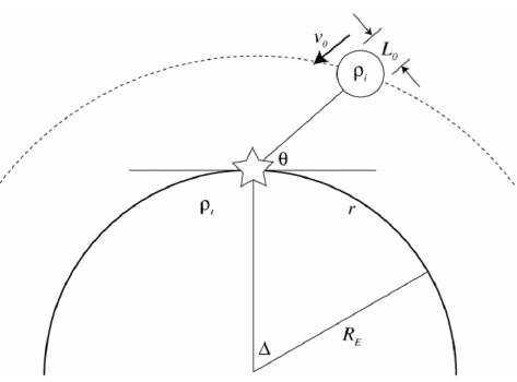
Figure 2 Diagram illustrating the input parameters for the Earth Impact Effects Program: L0 is the impactor diameter at the top of the atmosphere, v0 is the velocity of the impactor at the top of the atmosphere, ρiis the impactor density, ρt is the target density, and θ is the angle subtended between the impactor's trajectory and the tangent plane to the surface of the Earth at the impact point. The distance r from the impact site at which the environmental consequences are determined is measured along the surface of the Earth; the epicentral angle Abetween the impact point and this distance r is given by Δ= r/RE, where RE is the radius of the Earth (Collins et al., 2005).
Imput parameters for the simulation of environmental consequences
The following input parameters were selected with support from local and regional geological and geophysical studies of the probable Vichada impact structure (De la Espriella et al., 1990; Hernandez et al., 2009; 2011; Khurama, 2007; Rocca, 2004), complemented with information from theoretical asteroid impact crater effects
Impactor density (pi):
Asteroids are made of rock (ρi ~2000-3000 kg/m3; Hilton, 2002) or iron (ρi ~8000 kg/m3). About eight out of ten meteorites seen to fall are chondrites (Bevan and Laeter, 2002). Therefore, a density value of 3.0 kg/m3 has been assigned to the extraterrestrial impact body to represent a chondritic meteorite.
Impact velocity (v0):
Asteroids typically collide with the Earth's atmosphere at velocities of 12-20 km/s (Bottkeet al., 1994). Taking into account the diameter of 3220m and density of 3.0 kg/m3 of the impactor, a high impact velocity is expected because the Earth's atmosphere is not capable of retarding such a large mass (Heide and Wlotzka, 1995). In other words, the probable asteroid that could produce the Vichada structure could strike the surface of the Earth after having loss only a small fraction of its cosmic velocity; therefore, an impact velocity of 20 km/s has been selected (Heide and Wlotzka, 1995). Similar simulated environmental effects have used an impact dunite impactor, impacting at 20 km/s and found none of the impactor remained solid (Pierazzo & Melosh 2000)
Impacting angle (θ):
The impacting angle is that angle at which the trajectory of the impactor subtends with the surface of the Earth at the impact point (Shoemaker, 1962). An impacting angle of 900 has been selected based on the perfect symmetric spherical shape of the Vichada impact structure and taking into account the simplified case of vertical impact of an airless planetary body without a surficial water layer or target heterogeneity (Gareth et al., 2012). Most impacts occur at an oblique angle, the percentage of impactors that strike at impact angles less than 60o and less than 30o to the target surface is 75% and 25%, respectively (Shoemaker, 1962). Therefore, the vertical impact case is the best studied and serves as a useful exemplar of many of the processes common to all impacts (Gareth et al., 2012).
Target rock:
A sedimentary cover, composed by a heterogeneous sequence of conglomerates, sandstones and claystones has been selected as representative of the target rock hit by the asteroid. The specific density of the target rock is 2.4kg/ m3. This value was also assigned to the sedimentary cover in the inverse modeling of ground complete Bouguer gravity anomalies by Hernandez et al., (2011).
Diameter of the impactor (L0):
Taking into account the density of the target and impactor, the impact velocity and the angle of impact, several calculation were made by applying the utilities of the impact calculator (Lowe et al., 2017) to obtain a final crater dimension of 50 km of the Vichada structure obtaining an Impactor diameter of 3220m, being consistent with the measured impact crater structure from the TM-Landsat imagery, geographical features and fieldwork reconnaissance.
Distance away from the impact (r):
Seven different distances away from the impact crater central point were chosen at which the environmental consequences were calculated, including Cumaribo, Vichada (70km away), Puerto Inirida (150 km away), Puerto Carreño (260 km away), Puerto Gaitán (320 km away), Mitú (370 km away) Villavicencio (494km away) and Bogotá D.C. (545km away). The point data results obtained at each location have been linearly interpolated to map regional the environmental consequences. Based on these results, a window of the fist 100km away from the Vichada Structure has been selected to carry out fieldwork activities among with seismic lines and borehole data compilation and interpretation.
Results
The environmental consequences are estimates based on limited understanding of the impact process and come with large uncertainties; they should be used with caution, particularly in the case of peculiar input parameters with a weak geological support. All values are given to seven different locations away from the center of the impact crater structure (tables 1 and 2). Data processing of the point data solutions has been applied to obtain the regional environmental effects (figures 3 to 5). Uncertainty associated with these calculations is discussed in Collins et al., 2005. The main environmental effects are:
- Time for maximum radiation: 2.19 seconds after impact
- Thermal Exposure: 1.01 x 10⁹ Joules/m2
- Duration of Irradiation: 9.47 minutes
- Radiant flux (relative to the sun): 1770
- Transient Crater Diameter: 31.7 km
- Transient Crater Depth: 11.2 km
- Final Crater Diameter: 50 km
- Final Crater Depth: 961 meters
- The crater formed is a complex crater.
- The volume of the target melted or vaporized is 93.1 km3
- Roughly half the melt remains in the crater, where its average thickness is 118 meters.
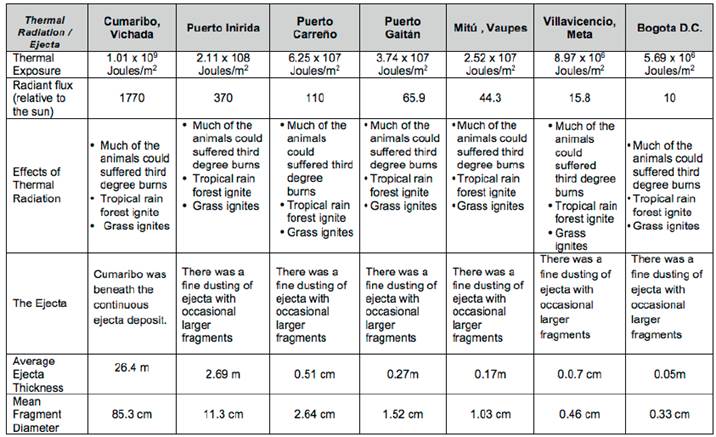
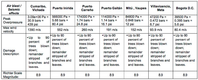
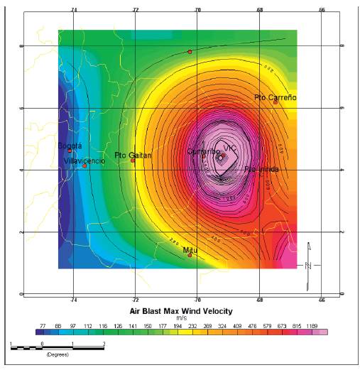
Figure 3 Air blast maximum wind velocity, in meters per second , with maximum velocities above 800 m/s in the Vichada structure
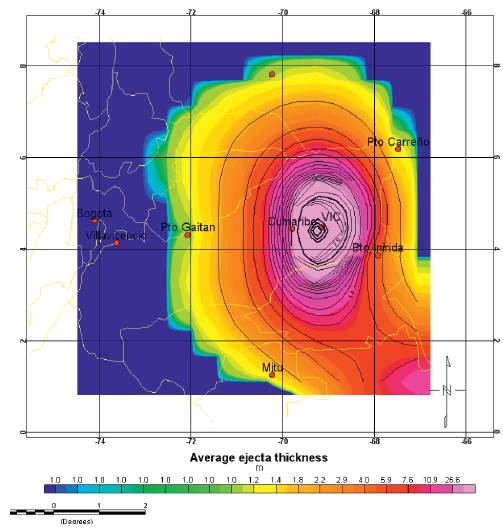
Figure 4 Average ejecta thickness, in meters, showing more than 25m of ejecta thickness in the surround of the Vichada structure that could be preserved in the geological record.
Conclusions
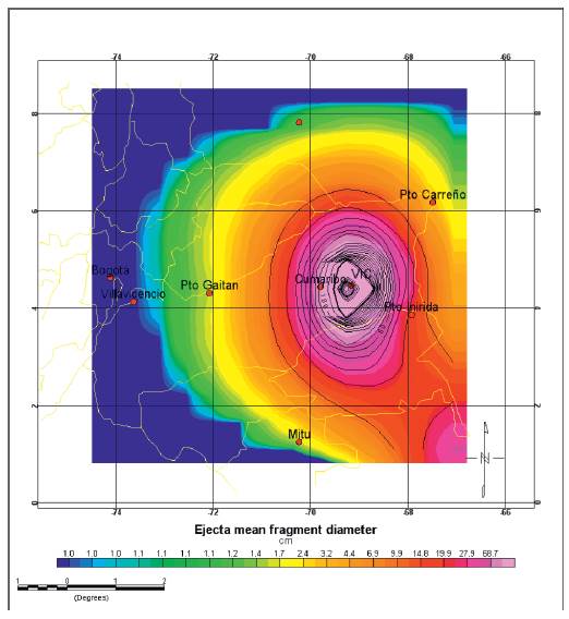
The hypothetical regional environmental consequences of the collision of the probable Vichada impactor have been calculated providing a catastrophic scenario for the first 100km away from the impact center. The seismic shaking of 8.9 intensity in the Richer scale could be the most significant effect at short and large distances from the impact site; effects of ejecta fallout and the air blast decrease much more rapidly with distance away from the impact site, being significant at Cumaribo (70 km away), almost undetectable at Puerto Inirida (150km away) and neglectable and impossible to recognize at distances greater than 150km away, such as Puerto Carreño (220km away) and the other four points of observation in Puerto Gaitán, Mitú, Villavicencio and Bogotá.
The timing analysis of the environmental consequences shows that the seismic shaking could take only up to two minutes from the impact center to the larger distance at Bogotá D.C, while the ejecta arrival could take near six minutes (three times longer) and the air blast takes about 28 minutes (14 times longer) to arrive at the larger observation point. This difference of the arrival time at each location is extremely important, due to the fact that local deformation and disruption of lithological units and ejecta material could be preserved near the impact crater, in the first 100km from the impact site. This is a significant result as it allows reducing the studied area to search and to hunt for direct geological evidence of the Vichada impact crater.
Estimates of the average ejecta thickness and ejecta mean fragment diameter are also important to conduct detailed geological studies, and borehole and seismic data compilation and interpretation in the inner ring, outer ring and the first 50km away from the probable impact crater, where we expect to find ejecta thickness greater than 20m with mean fragment diameter greater than 1m. Estimates of maximum fireball radius, air blast wind velocity and air blast sound intensity are almost impossible to validate from the geological and geophysical record.
Recommendations
The calculated environmental effects of the probable Vichada impact crater has applied a modeling in which it was necessary to make general assumptions in the input parameters, limiting the accuracy of the results. Therefore, the obtained results must be use with care. Until now, The Vichada impact structure is not a proven asteroid impact crater. We expect to provide a hypothetical scenario waiting to be proven or disproven by future detailed geological and geophysical studies in the area.

