English (pdf)
 Article in xml format
 Article references
 Send this article by e-mail
 Cited by SciELO
  Cited by Google
  Similars in
SciELO
Similars in
SciELO  Similars in Google
 Permalink
Introduction
Of all natural phenomena that can present serious threats to property and human life, earthquakes probably claim the most victims and cause the greatest material losses per unit of time (Perepérez, 2014).Therefore, researchers attempt to find meaningful temporal patterns in the occurrence of earthquakes along specific faults (Dowrick, 2003; Işık and Kutanis, 2015), as well as spatial patterns in the associated damages to structures.
It is notably accepted among the earthquake engineering that local geology especially sediment thickness has a crucial effect on seismic motion (Livaoğlu et al., 2015). Soft sediments make an important component of the subsurface lithology and carry a special nuisance in seismic hazards, as they serve as a source of seismic amplification (Khan & Khan, 2016).
Among the factors that determine those spatial patterns are topography, magnitudes of regional earthquakes, and distances of population centers from epicenters. In addition, it has been noted repeatedly that adjacent areas underlain by different soil types suffer different degrees of damage during earthquakes (Meslem et al., 2012, Vucetic, 1992). Such is the case in the state of Chiapas, Mexico, where local soil conditions play a fundamental role in seismic responses of structures.
Dynamic responses of soils to earthquakes vary significantly, and include such phenomena as soil failure and liquefaction. For that reason, municipal planners must consider the seismic response of each locality's subsoil, in order to define the specific parameters of structural design seismic resistance appropriate to the seismic history of the region (IPCMIRD, 2010).A detailed spatial analysis of the history of damages caused by earthquakes in a specific locality is essential for identifying that locality's amplification zones. Studies such as the present, which consist basically of defining micro-zoning of seismic hazards, must look for evidence of varied soil responses within the area of interest, then communicate that information to builders and urban planners by means of maps in a cartographic database (Tupak, 2009).
Using geo-referenced information from such databases as inputs, software for modeling seismic responses of structures can estimate the level of damage that will result to buildings at specific sites, during earthquakes of magnitudes expected within the region (Işık and Kutanis, 2015).
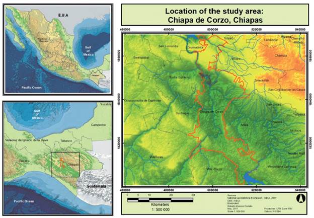
The area of study in the present article is Chiapa de Corzo, in the center of the state of Chiapas (Fig 1). The city has suffered frequent earthquakes during the last century because of the subduction of the Cocos tectonic plate under that of North America (García and Suárez, 1996). For example, the traumatic earthquake of 1975 changed the city radically by destroying traditional adobe houses that dated to the city's foundation (Nandayapa 2011).Infrastructure systems failed, and most of the city was affected. Table 1 lists dates, magnitudes, and epicenter locations for 18 of the most significant earthquakes that have affected Chiapa de Corzo during the last 120 years.
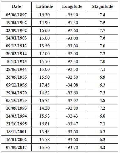
In the present article, which seeks a correlation between sediment thickness underlying Chiapa de Corzo and the city's historic patterns of seismic damage, we use historical records from two events:
■ The earthquake of magnitude 4.8 on Monday, 6 October 1975, at 12:55 a.m. local time. It caused major damage to Chiapa de Corzo. The epicenter was located in Ribera de Cupía, Amatal and América Libre rural localities approximately 4 km southeast of Chiapa de Corzo. This earthquake was produced by cortical failure, induced by filling the reservoir of the "La Angostura" dam (Nandayapa, 2011).
■ The magnitude-8.2 earthquake of 7 September 2017, whose epicenter was in the Gulf of Tehuantepec, 133 km southwest of Pijijiapan, Chiapas. This earthquake caused heavy damage in metropolitan areas of Chiapas (SSN, 2017).
Zoning studies are needed urgently in Chiapa de Corzo because of the city's many historically significant buildings, high level of marginalization, and high degree of deterioration of the housing stock.
Geological characteristics of the study area
Chiapa de Corzo lies along the banks of the Grijalva River, and is contained within the River's flood plain. The entire urban area is built upon alluvium (Schmudde, 1968).In general, seven types of rock are exposed within metropolitan regions of Chiapas. Soils in most locations are quaternary deposits. Three types of bedrock predominate: limestone (34.46% of the surface), siltstone-sandstone (29.01%), and shale-sandstone (16.55%). Cretaceous deposits are also present: siltstones (8.99%) and alluvial (7.22%). The remaining 5.40% of Chiapas's surface area is covered by soils of varied compositions (INEGI, 2004; INEGI, 2008; PDM, 2017).
The study area's shales are fine-grained rocks that fracture in laminated slabs more or less parallel to the stratification. Particles within these rocks are so small that their mineral compositions are difficult to determine precisely. It is important to note that the shales contain clay minerals, as well as silt, quartz, feldspar, calcite, and dolomite particles (Don Leet and Judson, 1980; Blanquer, 2011).
In contrast, sandstone is formed by the consolidation of individual grains of the size of the sand (1/16 mm to 2 mm diameter). Sandstone occupies, then, an intermediate position between conglomerate, which is coarse-grained, and the lodolite, which is fine-grained. Grain size varies from one sandstone to another. Sandstones and shales constitute about 99% of all sedimentary rocks, the shales being the most abundant (Don Leet and Judson, 1980).
Methods
This research seeks to propose the relationship between flood zones associated with areas of greater sediment thickness and site-effect zones as a preliminary analysis to identify these areas in regions where studies have not been conducted.
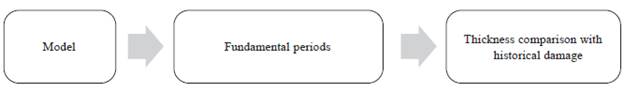
The methodology followed in this work consists of three fundamental stages (Fig 2). In the first stage, a mathematical model was defined to calculate thicknesses of sediment layers in Chiapa de Corzo. Next, the fundamental vibrational periods of soils in each zone of the city were obtained from Salgado et al. (2004). Finally, historical records of earthquake damage to the city were reviewed in order to correlate soil thicknesses with local seismic amplification.
Model
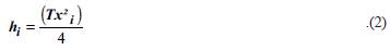
Newmark and Rosenbleuth (1976) derived the following equation for the fundamental vibrational period (T) of a terrain that is underlain by n sediment strata:
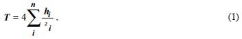
where h i . and β i . are, respectively, the thickness of the i th stratum and the propagation rate of shear-waves within it. To estimate the total thickness of sediment at each of the 20 locations for which Salgado et al. (2004) determined the terrain's fundamental period, we assumed, based upon (Narcía et al, 2006), that β = 150 m/s within all sediment layers throughout Chiapa de Corzo's urban area. Therefore, our estimate of the thickness h present at a location with period T seconds was
Fundamental periods of soil vibration
As noted in the previous section ("Model"), fundamental periods for 20 locations within Chiapa de Corzo's urban area were obtained from Salgado et al, (2004). Periods ranged from 0.14 to 0.39 s; with most near 0.3 s.
Historical Damage
The last step in the methodology was to develop a database, in Excel (Fig 3), of levels of damage caused to structures in Chiapa de Corzo by the earthquakes of 6 October 1975 and 7 September 2018.
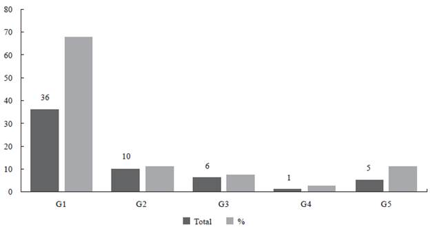
Figure 3 Degrees (grades) of damage caused to buildings in the urban area of Chiapa de Corzo bythe earthquakes of 6 October 1975 and 7 September 2017. Grades ranged from G1 (negligible) to G5(total collapse of the building).
Through our own on-site examinations and from previous research, we also investigated whether the inherent seismic vulnerability of structures (for example, that due to design, materials, and construction methods) varied significantly among the twenty sites at which Salgado et al. (2004) measured fundamental periods.
Results
In addition to the graph shown in Fig.8, a correlation between the period of vibration and the thickness of sediments is observed.
Fig. 4, prepared by ArcMap via linear interpolation of fundamental-period data from Salgado et al., (2004), shows the spatial variation of fundamental vibration period within Chiapa de Corzo's urban area. Sediment thicknesses, as estimated via Eq. (2) using data from Salgado et al., (2004), ranged from 7.12 m to 14.6 m. Fig.5 contrasts surface topography with estimated thickness of underlying sediment in the central zone of Chiapa de Corzo. Comparing the interpolated spatial distribution of estimated thicknesses (Fig. 6) to historical patterns of damage (Fig. 7), we find that damage has been greater where sediments are estimated to be thicker.
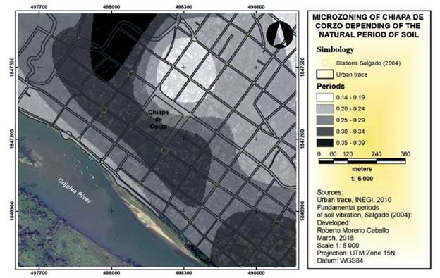
Figure 4 Micro-zoning of the city of Chiapa de Corzo according to the fundamental period of the underlying sediment. Circles show locations of Salgado et al. (2004)'s measuring stations.
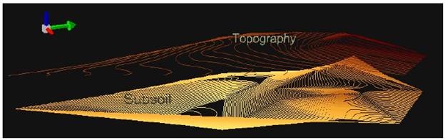
Figure 5 Comparison between surface topography and estimated thickness of underlying sediment in the urban area of Chiapa de Corzo. The green arrow points toward north.
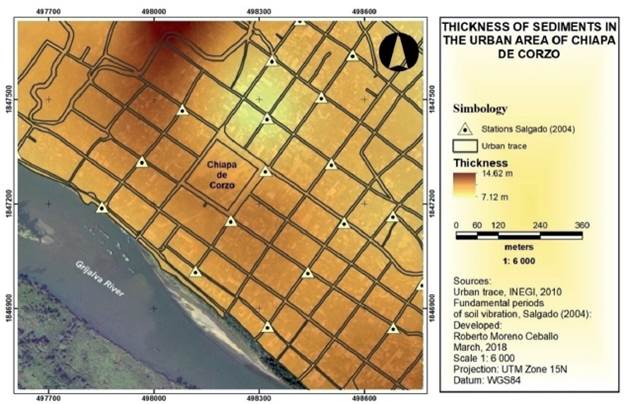
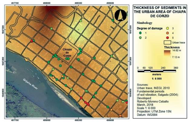
Figure 7 Comparison of sediment thicknesses and earthquake damage suffered by buildings in the urban area of Chiapa de Corzo. Degrees of damage range from 1 (negligible) to complete collapse (5).
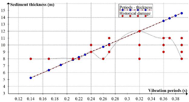
Figure 8 Correlation between period of vibration (from Salgado et al. (2004)),thickness of sediments (as estimated in the present article), and historical patterns of earthquake damage to buildings in Chiapa de Corzo.
Importantly, the inherent seismic vulnerability of structures did not vary significantly among the twenty sites. (For example, see Cardona, 2008).
Conclusions
For the purposes of the work reported here, sediments underlying each site in Chiapa de Corzo could be modeled as homogeneous deposits with β = 150 m/s. The resulting estimates of thicknesses correlate with degrees of structural damage that occurred during the earthquakes of 6 October 1975 and 7 September 2017: where the estimated thickness is greater, so was the degree of damage. Thus, in the case of Chiapa de Corzo, estimates of sediment thickness calculated from measurements of the terrain's fundamental vibrational period can be a fundamental input for defining micro-zones based upon dynamic response of soils.
This conclusion would not be tenable if the inherent seismic vulnerability of structures varied significantly among 20 sites at which Salgado et al. (2004) measured fundamental periods (Padrón et al, 2011). That caution is an important one which future research in Chiapa de Corzo or elsewhere should consider when choosing sites at which to estimate sediment thicknesses.
In summary, dynamic response of subsoil is an important phenomenon that is sometimes given insufficient attention during the structural design of buildings and other engineering works. (See, for example, González-Herrera et al. (2013) regarding subsoil conditions in Tuxtla Gutiérrez, Chiapas.) Useful correlations for microzoning based upon this phenomenon can be developed by carefully analyzing and cross-referencing spatial patterns of earthquake damage and shear-wave velocities. The results obtained in this work should be supplemented by more-detailed studies that include current measurements located throughout Chiapas de Corzo's urban area, because population growth has been considerable during recent years.