


 English (pdf)
 Article in xml format
 Article references
 Send this article by e-mail
 Cited by SciELO
  Cited by Google
  Similars in
SciELO
Similars in
SciELO  Similars in Google
 Permalink
Introduction
China is a country with large geological resources. Generally speaking, China has a well-developed stratum, diverse sedimentary types, complex geological structures, frequent coexistence of magmatic activities in active zones and stable areas, and diverse types of long-term geohistory metamorphism with different metamorphic degrees (Sinitski, Thompson, Godsell, Honey, & Besemann, 2018). China is one of the regions with important geological characteristics in the world, and also one of the important areas to study the evolution of continental geological structures, especially the Mesozoic and Cenozoic crustal structures (Naqvi, Ali Hassan, Pervaiz, & Ni, 2018). Therefore, in order to better and more comprehensively understand the current situation of geological resources in China, many researchers use three-dimensional modelling algorithm and virtual display technology to study geology, which can not only help people to have more knowledge of geography, but also help researchers to study geological strata (Handong, Tuo, & Changhong, 2006). This is better than simple data for researchers to have a deeper understanding and experience of geological formations.
Visualization of scientific computing emerged in the late 1980s (Li, Cai, & Lu, 2018). It uses computer technology to convert the data of scientific or engineering calculation process and calculation results into graphics or images, and display these graphics or images on the screen for interactive processing theory, methods and techniques (Wu, Zhu, Lin, Zhuang, & Ma, 2018). Three-dimensional geological modelling technology is a branch of scientific computing visualization technology. It is the development and application of scientific computing visualization technology in the field of geosciences.
Therefore, in order to exploit and utilize the underground resources according to the specific national conditions of China, it is necessary to clarify the shape, attributes and spatial relationship of the underground geological structure, understand the basic structural and material characteristics of the geology, so as not to blindly exploit and utilize the underground resources and avoid unreasonable development and loss (Liu et al., 2018). However, due to the late start of three-dimensional geological modelling technology in China, the lack of geological data, and the complexity, fuzziness and uncertainty of geological spatial distribution and structure, it is difficult to study three-dimensional geological modelling and visualization (Zhao, Wang, & Martinez, 2018). However, with the development of science and technology, some new methods and techniques have emerged in the exploration and acquisition of underground resources. People can obtain more detailed, comprehensive and abundant geological data through high-tech, which also provides material and data basis for the establishment of three-dimensional geological visualization model (Buttussi & Chittaro, 2018). On this basis, an intuitive, clear and complete three-dimensional geological visualization model is established, and the structure and characteristics of geological bodies are presented concisely and concisely by means of virtual images (Zhu, Lu, & Rãtsch, 2018). This model can not only describe the geological structure and characteristics comprehensively, but also relieve the pressure of staff members. At the same time, it can also provide certain theoretical basis for relevant staff to make reasonable exploration and development decisions. On the other hand, it is also conducive to the popularization of geological knowledge.
Methodology
Key algorithms for 3D geological modelling
Geological Body is a term often used in geological work. It usually refers to the product of geological processes that occupy certain space in the earth' s crust, especially the inherent components and can be distinguished from the surrounding materials. No matter how large or small the geological body is, whether it reaches a rock mass or an inclusion, it can be called a geological body. In geophysical prospecting, it refers to the object to be looked for when applying geophysical methods to study geological problems. Therefore, geological body is often the geological factor causing anomalies. Sometimes, it is common with anomalies. Geological bodies occupy a certain space in the crust and have certain composition, which is a natural entity different from its surroundings. The study of geological bodies is of great significance in searching for various useful deposits and seismotectonic active belts.
The data format and data structure of geological data play an important role in the three-dimensional geological body modelling. Its organization mode determines the methods used in the three-dimensional geological modelling. Therefore, understanding the data organization commonly used in the three-dimensional geological modelling is of great value to the three-dimensional geological modelling. The geological data which are studied more at present is chosen as the research object, that is, borehole data. It provides data support for the algorithm research of three-dimensional geological modelling.
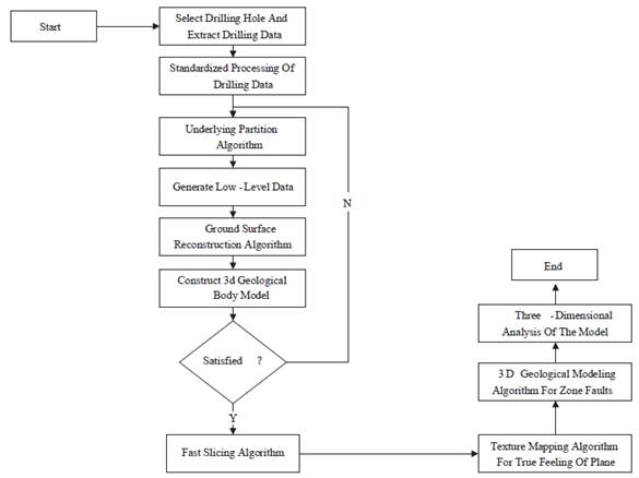
Diamond data is the most common type of data in three-dimensional geological modelling. Borehole data is obtained by engineering drilling method. It can directly obtain detailed rock and soil distribution by drilling core. It is necessary to obtain borehole data, distribution data of boreholes and strata, and the description of the global bottom, which lays a theoretical foundation for the follow-up study of geological virtual display system. Borehole data is very important in three-dimensional geological modelling because of its intuitive, accurate and detailed characteristics. The flow chart of three-dimensional geological modelling of borehole data is shown in figure 1.
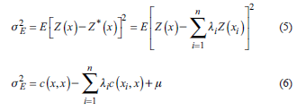
Stratigraphic division is to determine how many strata there are in a geological body and the interface data of each stratum. Assuming that there are five drilling points in a drilling area and obtain data from them, each drilling point has coordinates of x and y directions. Geological information obtained at different heights may be different. Stratigraphic division is based on the numerical information of each drilling hole in different z coordinates. In this study, Shepard processing algorithm and Kriging algorithm are used to process it. The corresponding interpolation models are as follows:
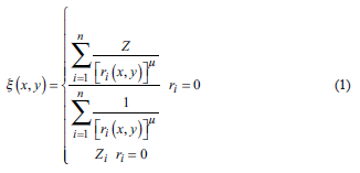
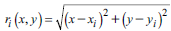 represents the distance from the interpolated point (x, y) to the sampling point (xi, yi.). The value of µ is taken as 2. The influence of the function value on the weight function is inversely proportional to the distance from the interpolated point to the sampling point. The larger the distance is, the smaller the impact is. The smaller the distance is, the greater the impact is. The two points are close to each other and have similar relationship in geological data, that is, the properties of the adjacent points are similar.
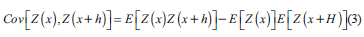
Kriging method is a spatial local interpolation method. It evaluates regionalized variables in the interpolation region by using covariance function, variation function and other models. The formula is as follows:
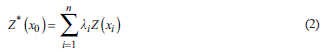
Where Z * (x0 ) represents the value of the point to be interpolated, Z (x i ) represents the value of the first sampling point, and λi; is the effect of the i-th sampling point on the interpolation point. In Kriging algorithm, the ordinary Kriging method has been widely studied in the field of Geology and has shown good results. Therefore, due to the uncertainty of drilling location and geological structure, some variables in the address data show random and structural characteristics and regionalized variables in spatial distribution. The difference between regionalized random variables can be expressed by spatial covariance.
The variation function of Z (x) at points x and x+h is denoted as y (x, h), and its expression is as follows:
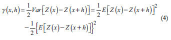
On this basis, unbiased estimates are made, and the estimated variance is as follows:
By analyzing the variance of Kriging estimation, whether the estimated value is the best one can be judged.
Virtual display system
As one of the emerging technologies, spatial information has become the main source of information for human beings to understand the real world around them and explore the unknown world. Establishing realistic large-scale virtual scene can help us understand spatial information. Therefore, in recent years, researchers pay more attention to virtual simulation technology. Moreover, it can realize human-computer interaction. Computer generates three-dimensional graphics and makes people feel three-dimensional environment through three-dimensional equipment. Moreover, people can freely control the three-dimensional graphics environment to achieve specific purposes. Virtual reality technology has the characteristics of immersion, interaction, multi-perception and sense of autonomy. Its greatest feature is that people have natural functions and perception, and can interact with computer-generated virtual systems in real time.
Virtual reality system provides us with a convenient and realistic way to communicate with computers. It is a powerful tool for us to understand and transform the world. It has attracted the attention and research of many well-known scholars all over the world. Through the efforts of various researchers, it has made some brilliant achievements. It can be foreseen that with the rapid development of computer hardware and software technology, virtual reality technology will further develop and change our lives.
As a result, the National Geological Information Library successfully launches the virtual exhibition hall. On the one hand, it can give full play to the role of scientific popularization of geological data and documents, and popularize geological knowledge. On the other hand, it also provides scientific and technological means for researchers to study geological conditions and disaster situations more comprehensively.
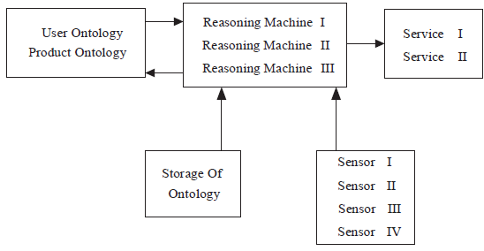
In the specific design of the display system, many perceptrons, reasoners, ontologies and service providers are involved in the structural model. Next, these key points are elaborated in detail. By constructing a series of generic ontologies, a bridge for context-aware intelligent mobile services can be built to communicate and express with each other.
In this three-dimensional virtual display platform, the ontology structure is divided into several sub-ontologies, which are object ontology, service ontology, computing ontology, perception ontology and storage ontology. Object ontology includes user ontology and product ontology. Service ontology includes services. When the system decides that users need some information, it feeds back the information to users and service system to recommend products to users in time. Computing ontology contains three reasoners, which is the core part of the system. There are four sensors in perceptual ontology, and storage ontology is fused in the above ontology in practical application. To deal with the huge and strict data information, it is necessary to use data storage and computing tools in colleges and universities, as shown in figure 2.
Results and discussion
This study collects borehole data of a certain area, as shown in table 1.
Table 1 Borehole data of a certain area
| Well | Well | Well | Well | |
|---|---|---|---|---|
| Geological condition | drilling | drilling | drilling | drilling |
| P[1] | P[2] | P[3] | P[4] | |
| Below Depth (1) | 1 | 1 | 2 | 1 |
| Below Depth (2) | 3 | 2 | 3 | 2 |
| Below Depth (3) | 5 | 3 | 5 | 4 |
| Below Depth (4) | 6 | 5 | 6 | 5 |
| Below Depth (5) | 7 | 7 | 7 | 6 |
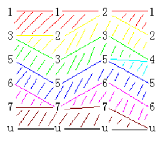
Stratigraphic division of geological conditions is carried out by the algorithm, and the results are obtained, as shown in figure 3.
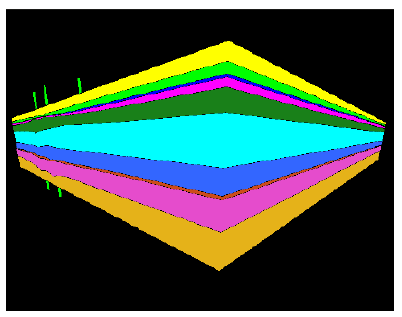
The three-dimensional geological model thus established is shown in figure 4.
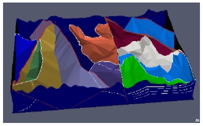
The result of virtual display is shown in figure 5.
In addition, through the analysis of the calculation results of the algorithm, it can be seen that the parallel algorithm of Shepard method and Kigring method is more efficient than that of the single one in the case of two cores. Moreover, in the case of four cores, the efficiency of the parallel algorithm is much higher than that of the two cores, which shows that the parallel algorithm can reduce the events of program execution and improve the efficiency of modelling. It is also very helpful to the operation of virtual display system.
In summary, on the basis of collecting relevant data of geological body, using the key algorithm of three-dimensional modelling not only improves the operation efficiency, but also provides a good data support for the establishment of virtual display system, so that the final image can display the specific effect well, which is conducive to people' s further understanding of geological conditions and provides a good model for researchers to study.
Conclusion
With the continuous development of virtual display technology, researchers have a better understanding of the relevant information of geological bodies, and use the three-dimensional modelling algorithm to analyze, and ultimately complete the design of the display system. Based on the three-dimensional geological modelling process of borehole data, the three-dimensional geological modelling modules are divided. The algorithm of stratum division and surface reconstruction are studied and realized. In the algorithm of surface reconstruction, Shepard and Kriging are used to implement the two methods respectively, and the two algorithms are analyzed and compared in detail. The design and research of the two algorithms in the geological virtual display system are realized. However, in the design of virtual display system, less consideration is given to the data that may affect the model, so more relevant data will be studied in the future. This study also provides ideas for other aspects of three-dimensional modelling, and has a reference significance for the wider application of virtual display technology.

