Introduction
One of the main environmental problems treated in recent years has been to solve soil erosion, which has increased worldwide, due to the need to expand the agricultural frontier to produce food and provide habitat for a growing population.
Situation that has led to the analysis, in many countries, looking to establish as anthropogenic conditionings, interact in the activation of erosive processes, in order to evaluate and zone the risk levels, and to design measures responding to each environmental reality.
In the case of Ecuadorian coastal region the socio-environmental conflicts, are specifically because more than 60% of the population, is engaged in agricultural activities not productive, in addition to the fact that they employ few mechanisms that are sustainable for the environment, which leads to pollution and the degradation of soils, forests and waters, thus decreasing the population's quality of life (Instituto Nacional de Estadística y Censos [INEC], 2010).
In the drainage catchments of the Manabí province, the sensitivity to the activation of erosive processes, represents a serious environmental problem, that results in the loss of soil resource, with the consequent reduction in agricultural productivity, increase in areas without vegetation, decrease in water quality, and the intensification of floods, among other scenarios (Desinventar, 1994).
So the qualification and quantification of soil erosion, is important as regards, assessing land units because it has effects such as the loss of the nutrients required for crop growth, the accumulation of sediments in river channels, and a reduction in water storage capacity owing to soil loss, thus reducing the natural flow of catchments (Fonseca et al., 2014).
It is as these in recent years, there have witnessed a significant increase in the use of geotechnological tools (remote sensing [RS] and GIS) to study soil erosive processes. The principle objectives of many of these contributions are: (a) the multi-temporal and spatial modeling of erosive processes (Zeng et al., 2013); (b) the analysis of the effects of the changes in vegetal cover and land use (Lech-hab et al., 2015); (c) the quantification of soil loss (Parveen and Kumar, 2012; Farhan et al., 2013; Amsalu and Mengaw, 2014; Lahlaoi et al., 2015; Ganasri and Ramesh, 2016; Tahiri et al., 2016); (d) the zoning of the hazard and risk control (Prasannakumar et al., 2012; Gaatib and Larabi, 2014; Uddin et al., 2014; Chirala et al., 2015); and (e) soil mapping and classification (Alves et al., 2015; Rizzo et al., 2015; Moura-Bueno et al., 2016).
Likewise, in most of the contributions mentioned above, emphasis is placed on the use of the R factor of the revised universal soil loss equation (RUSLE) as an indicator of the soil erosion risk. However, little has been done about it in Ecuador.
In this sense, quantitative studies conducted in the Ecuadorian Sierra by De Noni and Trujillo (1986) reveal that the land lost due to erosion are considerable. For example, the results fluctuate among 200 to 500 t.ha-1.y-1 for 1982. The experiments clearly demonstrated the close relationships between runoff and rainfall intensity, in particular the maximum rainfall intensity in mm h-1 during 30 min and of medium frequency (IM30), which fluctuate in the Ecuadorian coastal region between 40 and 70 mm h-1.
In this order of ideas and taking into account, the relevance of the Manabí province, for the Ecuadorian productive sector, in terms of agricultural potential and the propensity of the physical environment, to activate erosive processes, the purpose of this paper, was to use geotechnological tools, to zone the soil erosion risk, in order to spatiality analyse the problem, identify the most critical areas in the province, and propose possible control measures.
Study area
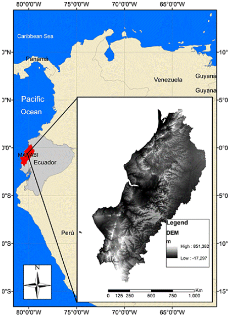
The Manabí province is divided into 22 cantons that cover an area of 1,942,764.33 ha located on the north-western Pacific coast of Ecuador and whose geoastronomical coordinates are latitude of -1.39° and 0.55° S and N, respectively, longitude of 79.38° - 80.93° W. The area has an altitudinal range from 0 to 851 m.a.s.l. (Figure 1).
The rainfall regime is unimodal with more than 9 dry months on the coast with annual amounts of less than 200 mm, and progressive increase in a W-E direction until reaching an annual rainfall of 3,000 mm in the north-eastern region (Instituto Nacional de Meteorología e Hidrología [INAMHI], 2016).
Large coastal plains and fluvial valleys, in addition to some mountainous systems with maximum elevations of 851 m.a.s.l, mainly represent the relief. The major fluvial systems are formed of the drainage catchments of the Chone and Portoviejo rivers (Winckell et al., 1997).
The lithology consist of more than 90% poorly consolidated sedimentary rocks. This is represented by rock outscrops belonging to the following lithological units: Piñón Formation (Cretaceous; basaltic lavas, tuff and breccias), Cayo Formation (Cretaceous; grauwackes, shales and basaltic mantles), San Mateo Formation (Eocene; sandstones and conglomerates), Zapallo Formation (Eocene; conglomerates, sandstones and shales), Dos Bocas Formation (Oligo-Miocene; shales and mudstones), Villingota Formation (Miocene; shales and sandstones), Angostura Formation (Miocene; coquinas, sandstones and mudstones), Onzole Formation (Miocene; shales and siltstones), Borbón Formation (Pliocene; tobaceous sandstones), Balzar Formation (Pliocene; sands, conglomerates and clays), San Tadeo Formation (Pliocene; volcanic fan and lahars), Tablazo Formation (Pleistocene; bioclastic marine terraces) and Marine Terrace (Holocene; estuarine marine clays) (Ministerio de Minería [MM], Instituto Nacional de Investigación Geológico Minero Metalúrgico [INIGMM], 2017; Enríquez, 2018).
Residual soils are composed primarily of very plastic and expansive clays. There are also large areas that are covered with silt, which has a high degree of collapsibility and scattering materials. These materials are easily mobilized and lose their strength as soon as they are excavated, thus making them easily erodible by runoff action (Aguirre and Chávez, 2009).
The coverage of the native forest in the Ecuadorian coastal region has been reduced and continues to decrease significantly in habitat extension and quality. This has caused an irreparable loss of its biodiversity, as a consequence of intensive deforestation and other human activities (Cornejo, 2011). The land use and cover is primarily agricultural and pasture and it is the first-ranked province in the country as regards total agricultural land with 1,643,428 ha (INEC, 2015). This represents 21.16% of the country's productive activities in the economic sector, which accounts for 14% of provincial gross added value (INEC, 2016), and which represents 37.1% of the economically active population (INEC, 2010). This productivity is mainly supported by family farming occupying average areas of 4 ha per farmer (Monteros and Salvador, 2015).
Material and methods
Soil erosion risk
The soil erosion risk was estimated by employing a combination of the precipitation, the R factor of the USLE, topography with a slope map from the DEM ASTER, vegetation cover using NDVI, land use and infiltration capacity variables from Ministerio de Agricultura, Ganadería, Acuacultura y Pesca [MAGAP] (2016). The variables were reclassified into five classes of soil erosion risk, as follows: 1 (very low), 2 (low), 3 (moderate), 4 (high) and 5 (very high). The variables were combined using a weighted ratio, obtained from expert judgment by means of a multi-criteria evaluation (Starkloff and Stolte, 2014; Vulevic et al., 2015), and using software for the analysis and interpretation of satellite images and GIS, specifically those related to map algebra. The weighting process of the factors determined the following results: 20% (0.2) for the USLE R factor, 30% (0.3) for the topographic slope, 30% (0.3) for the NDVI, 10% (0.1) for land use, and 10% (0.1) for soil texture, expressed as follows:
Soil erosion risk = (R*0.2) + (S*0.3) + (NDVI*0.3) + (LU*0. l) + (ST*0.1
Where:
R = USLE R factor (rainfall) (MJ mm ha-1 h-1 y-1)
S = slope (°)
NDVI = Normalized Difference Vegetation Index (dimensionless; the NDVI values range between -1 and 1, where the negative values correspond to areas without vegetal coverage and the positive values at different levels of vegetal coverage, with 1 being the highest density of vegetation)
LU = land use (dimensionless; the types of land uses were reclassified into 5 classes according to the following criteria: current land use, land use change and land protection policies)
ST = soil texture (dimensionless; the types of soil textures were reclassified into 5 classes according to the following criteria: coarse, moderately coarse, medium, fine and very fine)
The erosion risk map was reclassified into four classes according to the author's criteria. For the validation and calibration of the results obtained for this map, 50 control points were georeferenced in the field, which were superimposed onto the map in question.
USLE R factor
The USLE R factor was determined from processing rainfall records weather stations Camposano, Chone, El Carmen, Jama, Julcuy, Olmedo, Pedernales, Portoviejo and Rocafuerte, provided by the Instituto Nacional de Meteorología e Hidrología (2016) for the period 1984-2011. Any missing rainfall data were estimated by using rational and average substitution methods, while homogenization and consistency were estimated by means of the "rachas" or round method (Soares et al., 2012).
The influence of rainfall on erosive processes was estimated by considering the equation proposed by Echeverri and Obando (2010). This was generated and validated by carrying out a linear regression analysis of the Modified Fournier Index (MFI) and the monthly average I reported for 15 year records, with a determination index of 0.84 and a significance level of 5%. A Spearman correlation coefficient matrix was produced after considering the cases of significant and highly significant correlations. The simple linear regressions were determined to a significance level of 5%. The models with a determination index of ≥ 0.75 and a low variation coefficient (≤ 12%) were selected according to the expression:
Where:
R = erosivity (MJ mm ha-1 h-1 y-1)
MFI = Modified Fournier Index
The MFI was estimated according to the equation proposed by Arnoldus (1977) to represent climate aggression:
Where:
r. = mean rainfall of month i (mm)
R = annual mean rainfall (mm)
The information from each station was then employed to carry out a spatial interpolation in the GIS using the Ordinary Kriging method according to the criteria of Plouffe et al. (2015) and Panagos et al. (2016). The values of the R were subsequently employed to reclassify the map of rainfall erosivity into 8 classes by adapting criteria of Rivera and Gómez (1991), Páez (1999) and Olivares et al. (2013).
Slope (S)
The slope is one of the main dynamic factors to activate mass movements because it determines the kinetic and potential energy of an unstable mass. This increases susceptibility to the production of gravitational movements as the ground tilt increases. This instability is determined by the characteristics of relief, which have a significant influence on many variables involved in ecosystems dynamics and equilibrium (Sánchez et al., 2002). The slope is, overall, one of the main conditioning factors of erosive processes, sediment transport and runoff (as a result of both surface flow and subsurface flow).
The ground slope was calculated using the GIS spatial analysis tools, taking the ASTER DEM of 30 meters of resolution as a basis. The software slope tool has predefined algorithms with which to calculate the change in the maximum rate of elevation value of each cell with regard to its eight neighbours. The slope map was generated and reclassified according to the criteria suggested by Pacheco (2012), which is based on a detailed analysis of the ground slope distribution using topographic profiles that allowed the determination of clinometric ranges.
Normalized Difference Vegetation Index (NDVI)
The variable related to vegetation was obtained from calculations of the NDVI using Landsat LE70110612003128EDC00.TIF satellite image. The image was processed with atmospheric and geometric corrections (Chávez, 1989; Chávez and Kwarteng, 1989) in order to apply a cloud mask that allowed us to obtain the NDVI. This index was calculated by considering only two of the original bands provided by the sensor according to the expression (Chuvieco, 1996):
Where:
NDVI = Normalized Difference Vegetation Index
PIR = near infrared band
VIS = visible red band
The application of this equation enables an image with normalized values between 1 and -1 to be generated (Karaburun, 2010; Pacheco, 2012). The values close to 1 represent very dense vigorous vegetation, while negative and positive values near zero indicate regions devoid of vegetation. The method resulted in a regression model between the vegetation cover values measured in the field or obtained from the guide tables and NDVI values derived from the satellite image.
This information was then used to reclassify the standard deviation of the NDVI values (intervals = 1/3 of the deviation). The results show 6 classes, of which less than 4 correspond to water bodies, and whose variations are possibly owing to sedimentation, depth and vegetation. The highest values correspond to vegetation in different states of health, density and size.
Land use (LU)
The land use factor was evaluated and weighted by employing the map of coverage and land use of Ecuador elaborated by Ministerio del Ambiente de Ecuador (MAE) - Ministerio de Agricultura, Ganadería, Acuacultura y Pesca (MAGAP) (2015) at scale of 1:100,000 as input. Land use information from the map in question was obtained from field work and the analysis and interpretation of satellite imagery and high resolution orthophotographs. The spatial units of use include forests, agricultural lands, shrub and herbaceous vegetation, water bodies, anthropic areas (populated areas and infrastructure) and other types of land. Relative weights were assigned to each type of use depending on its influence on the activation of erosive processes. The criteria utilized for the allocation of weights and reclassification of land use map were based on those proposed by Paroissien et al. (2015), who consider current land use, land use change and land protection policies.
Soil texture (ST)
The soil texture map developed by MAGAP (2016) at scale of1:1,250,000 was used as the basis for the evaluation and weighting of this factor. The information presented on the map was obtained from field work and an analysis of soil samples, discriminated by lithological and geomorphological units. The textural groups presented on the map are coarse, moderately coarse, medium, fine and very fine (Ditzler et al., 2017). The assignment of relative weights to textural classes was based on expert judgment. The map was reclassified on the basis of the criteria proposed by De Lannoy et al. (2014) and Cisty et al. (2015), who considered hydric models with high precision algorithms and techniques.
Results and discussion
USLE R factor
The rainfall amounts (annual means) and their spatial distribution in the Manabí province can be observed in Table 1 and Figure 2. It is characterized by a progressive increase in rainfall from the coast towards the mountains in a west-east direction, with annual amounts of less than 400 mm on the coast, which is distinctive from the arid areas in the region located between Montecristi, Manta, Jaramijó and Sucre. Amounts significantly increase to annual values of 1,600 mm towards the north and south of the province, while maximum amounts close to 3,000 mm have been recorded in the north-eastern part, as registered in El Carmen canton.
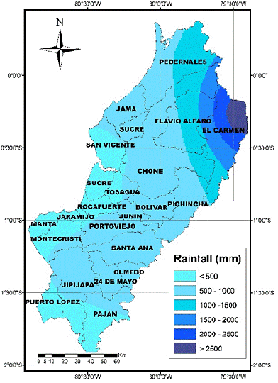
Figure 2 Spatial distribution of the annual rainfall in the province of Manabí, Ecuadorian coastal region.
The erosivity shows the same spatial distribution of the rainfall with the presence of low, moderate, high and very high classes. According to Rivera and Gómez (1991) Páez (1999) and Olivares et al. (2013), the territory is mostly covered by class 4, which is categorized as moderate erosivity (Table 1), and extends from north to south across the province as a central strip. This is followed by the high class to the center and east of the territory in a north-south direction. The low class is toward the coastal area in the Jama, Rocafuerte, Portoviejo and Manta axis. Finally, the very high class that covers the smallest area is concentrated to northeast of the Manabí province.
Table 1 Annual mean values of rainfall and erosivity in the Manabí province, Ecuadorian coastal region.
| Station | Annual rainfall (mm) | Erosivity R (MJ mm ha-1 h-1 y-1) | Area (Km2) | Area (%) | Erosivity class | Description |
| Rocafuerte | 471.04 | 3,162.12 | ||||
| Porto Viejo | 603.85 | 3,797.41 | 4,149.97 | 21.36 | 3 | Low |
| Jama | 687.52 | 3,990.93 | ||||
| Pedernales | 1,049.18 | 5,767.14 | ||||
| Julcuy (Jipijapa canton) | 869.16 | 6,024.03 | 8,067.56 | 41.53 | 4 | Moderate |
| Chone | 1,144.15 | 6,407.31 | ||||
| Camposano (Paján canton) | 1,364.27 | 7,815.62 | 6,187.25 | 31.85 | 5 | High |
| Olmedo | 1,625.53 | 9,001.34 | ||||
| El Carmen | 2,945.62 | 12,683.72 | 1,022.86 | 5.26 | 6 | Very high |
| Total | 19,427.64 | 100.00 | ||||
The USLE R factor is a measure of the erosive power of the rain that reflects its kinetic energy, it is directly correlated with the loss of soil and the amount of sediment carried by runoff and can, therefore, be considered as a good indicator of the erosion risk. Actions for the practice of sustainable agricultural activities should, therefore, be considered in sectors with high and very high erosivity.
However, in areas with low erosivity levels, it is possible to intensify erosion processes triggered by extraordinary rainfalls. In this sense, according to data from PORTOAGUAS (2017), with a total rain sheet of 70 mm for a duration of 24 hours, a turbidity in the Portoviejo river of 25,000 NTU was measured, which reflects a high erosion rate associated with that particular event, as well as a high amount of sediment carried.
Slope (S)
The low slopes are in the coastal areas and intermountain valleys (Table 2 and Figure 3), which serve as settlements for the largest cities in the province, of which Manta, Portoviejo, Chone, Calceta, Junín and Tosagua stand out. The erosive processes in these locations are minimal while, conversely, floods and sediment accumulation predominate. These areas account for over 74.65% of the territory and are categorized as having a low and very low influence on the activation of erosive processes.
Table 2 Area and percentage distribution of the slope classes in the Manabí province, Ecuadorian coastal region.
| Class | Slope (°) | Description | Area (Km2) | Area (%) |
| 1 | < 5 | Very low | 5672.87 | 29.20 |
| 2 | 4 - 15 | Low | 8829.86 | 45.45 |
| 3 | 15 - 25 | Moderate | 3772.85 | 19.42 |
| 4 | 25 - 35 | High | 1023.84 | 5.27 |
| 5 | > 35 | Very high | 128.22 | 0.66 |
| Total | 19,427.64 | 100.00 | ||
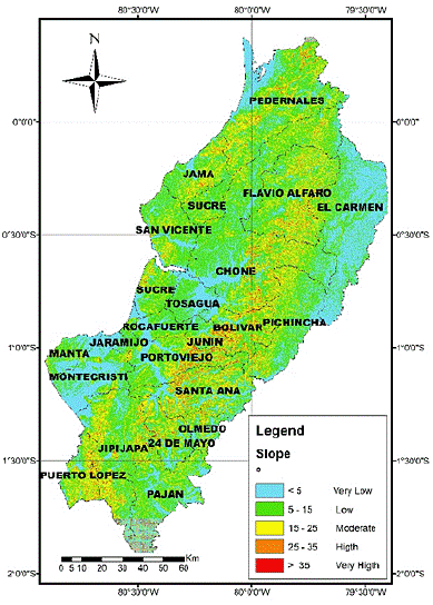
Figure 3 Spatial distribution of the topographic slopes in the province of Manabí, Ecuadorian coastal region.
The high and very high slopes cover 6% and the moderate slopes 19% of the province (Table 2) and are mainly located in the Central Mountain Range region (Flavio Alfaro, Chone, Bolívar, Junín and Santa Ana cantons) (Fig. 3) and, to a lesser extent, in the Pedernales and Jama northern and Jipijapa and Puerto López southern cantons. It is in these cantons where the slope conditions greatly influence the genesis of intense erosive processes.
Normalized Difference Vegetation Index (NDVI)
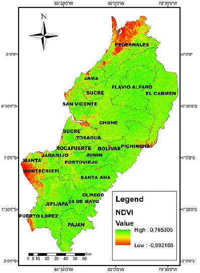
The NDVI has values ranging between -0.26 and 0.64 (Table 3 and Figure 4), thus indicating the presence of uncovered or few vegetation covered areas with below zero values. The majority of these areas are located in the coastal cantons, mainly in the center and south of the province. The presence of the densest vegetation cover with values above 0.5, although not completely vigorous, is observed with increased abundance in the cantons located in the eastern sector of the province.
Table 3 Area and percentage distribution of erosion risk according to the NDVI, Manabí province, Ecuadorian coastal region.
| Class | NDVI | Description | Area (Km2) | Area ( % ) |
| 1 | > 0.60 | Very low | 835.39 | 4.30 |
| 2 | 0.40 - 0.60 | Low | 3122.02 | 16.07 |
| 3 | 0.30 - 0.40 | Medium | 4509.16 | 23.21 |
| 4 | 0.20 - 0.30 | High | 6469.40 | 33.30 |
| 5 | < 0.20 | Very high | 4491.67 | 23.12 |
| Total | 19,427.64 | 100.00 | ||
Li et al. (2015) reported the recovery of vegetal cover in regions which ecological engineering projects were been carried out. This could be assessed by changes observed in the NDVI on satellite images. Their findings have shown that vegetation is effective in protecting soil from erosive processes.
Land use (LU)
According to the INEC (2015), Manabí is located between the Ecuadorian provinces with the largest areas of agricultural activity (permanent, temporary and fallow crops, natural and cultivated pastures). The cultivated and natural pastures comprise 886,633 ha, which allows them to provide habitats for the largest livestock production in the country, with 17.76% of the national total.
Land use is a dynamic process that spans several decades and has a significant influence on the activation of erosive processes. This is understandable when considering the soil disturbance prompted by local people on the mountainous hillsides, and that adversely affects the ecosystem functions. The annual and seasonal crops are those most prone to being affected by vulnerability, resulting in serious problems such as the indiscriminate felling of native trees and the pollution of water resources. These activities take place in order to obtain greater extensions of land devoted to the planting of agricultural products or livestock breeding (Rodríguez and Sandino, 2010).
The values shown in the Table 4 and Figure 5 indicate that more than 50% of the territory is predominately covered by different crops and pastures, located in the northern center of the province in the Portoviejo, Santa Ana, Chone, Flavio Alfaro, Jama and Pedernales cantons. These uses condition the activation of erosive processes. On a small area of the province the forest is preserved, in which the effects of erosion are decreased by the protection that this biome offers to the soil (García-Ruiz et al., 2008; Nadal-Romero et al., 2012).
Table 4 Area and percentage distribution of the land use classes, Manabí province, Ecuadorian coastal region.
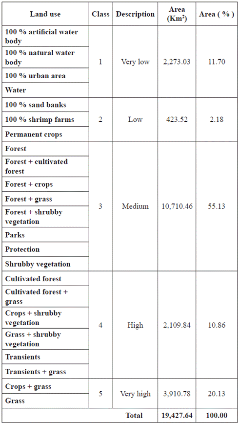
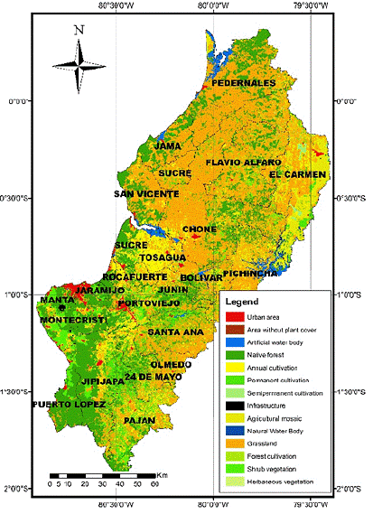
Figure 5 Spatial distribution of the land uses in the province of Manabí, Ecuadorian coastal region.
Another class includes the combined coverage of pastures and crops where there is bare soil during the dry season. This condition is highly prone to the activation of erosive processes with the first rains in the winter season, which move sediments from eroded hillsides toward the water bodies and urban areas, thus increasing the possibility of overflows and floods in addition to decreasing the quality and quantity of water intended for human consumption and the practice of agricultural activities.
Areas of greater disturbance resulting from uses associated with anthropic activities condition more severe soil erosion responses (high runoff coefficients) owing to their greater sensitivity to the impact of high intensity rainfall events (Regüés et al., 2014).
Soil texture (ST)
The distribution percent in the textural composition of soils (Table 5 and Figure 6) reflects the fact that fine (58.21%) and very fine (6.55%) material predominates almost 65%, which reduces the infiltration capacity and favors both the accelerated increase in runoff and the erosion rates.
Table 5 Area and percentage distribution of the soil texture, Manabí province, Ecuadorian coastal region.
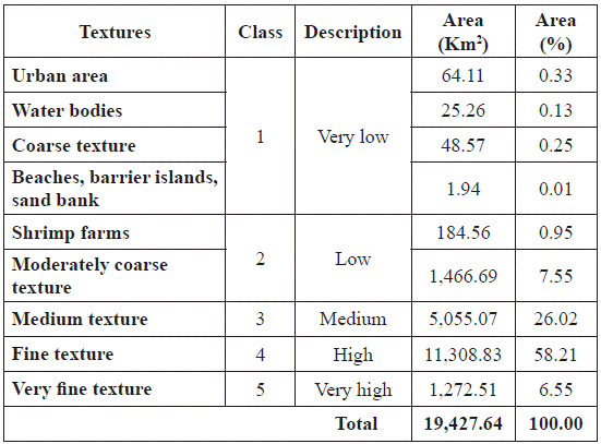
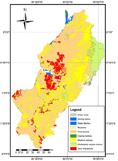
Figure 6 Spatial distribution of the soil textures in the province of Manabí, Ecuadorian coastal region.
The hydraulic parameters of the soil are strongly linked to its texture (De Lannoy et al., 2014). For example, sandy soils drain more easily than clay soils and have, given their moisture content, a much higher hydraulic conductivity that maximizes when soil physicochemical characteristics are altered by the occurrence of forest fires (Inbar et al., 2014). These fires occur frequently in the Manabí province, these fires are generated frequently, as is reported by some residents of rural parishes.
Spatially, there is a fine texture from north to south throughout the province with a compact presence in the western sector, while the very fine texture is concentrated in the Chone and Tosagua cantons. The mean texture is most predominant in the upper part of the Chone and Portoviejo river basins, and in the vicinity of the floodplain of the latter. The percentage of coarse and moderately coarse textures is concentrated in the El Carmen canton of the north-eastern sector of the province, and in some lots isolated from the upper and middle parts of the Portoviejo River basin.
Erosion risk map
As part of the validation and calibration process of the results obtained for the soil erosion risk map, 50 control points were georeferenced in the field in which evidence of erosive processes was observed, such as gullies and erosion grooves. These control points were superimposed onto this map, thus allowing us to discover a correspondence of more than 90% with the high and very high categories.
This map (Figure 7) allows us to visualize the spatial distribution of soil erosion risk in the province of Manabí, and also enables us to relate the different risk classes with the factors that have the greatest weight as regards their determination by interest areas (compared by the superposition of the final erosion map onto the map of each of the factors). This has allowed us to identify that the factors with the greatest influence on soil erosion risk are the slope and the soil coverage, thus corroborating the point made by Vulevic et al. (2015).
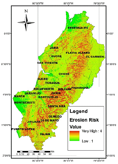
Figure 7 Spatial distribution of soil erosive risk in the province of Manabí, Ecuadorian coastal region.
In Manabí, the cantons (Flavio Alfaro, Chone, Bolívar and Pichincha) with highest erosion risk are located in the central-eastern sector of the province, concurring with the highest slopes, deforested areas and agricultural activity with inappropriate intensive use practices, such as the felling of native forests and the systematic burning of crop waste.
The main cantons with medium erosion risk (Portoviejo, Santa Ana, 24 de Mayo, Junín and Olmedo) are located in the southeast part of the province, coinciding with low to moderate slopes and moderate precipitation amounts. The cantons with the least erosion risk (Manta, Montecristi and Jaramijó) correspond to those located in coastal areas of center of the province, where gentle slopes prevail, and there are low amounts of rainfall and urban land use, protected by asphaltic and concrete infrastructures.
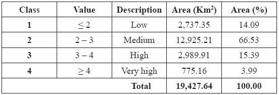
In the area distribution of erosion risk shown in Table 6, it observed that a low percentage of the territory shown a very high erosion risk. However, when considering the real extent that this percentage represents, government agencies consider that the erosion risk may have a high impact, and this is reflected in their planned protection activities. As an example, the Project for Provincial Forestation and Reforestation developed by the Provincial Government of Manabí, which must invest for more than 7 years in order to cover solely this portion of Manabí territory, fulfills the goal of 10,000 ha reforested per year.
Table 6 Area and percentage distribution of the soil erosion risk in the Manabí province, Ecuadorian coastal region.
For this program to be successful it is necessary to propose alternative technological changes in agricultural practices so as to avoid and reduce, for example, the felling of forests and fires in crop areas, which cause changes in the characteristics of the soil surface (Stoof et al., 2015). This modifies the roughness, thus increasing the erosion risk by surface flow, particularly when considering the projections of Routschek et al. (2014), who claim that one of the Climate Change scenarios reflects the increased intensity of rainfall, with a severe impact on soil loss, until at least 2050.
Additionally, Paroissien et al. (2015) reported that, in order to ensure soil resource sustainability, changes in their use must be taken into account. They proved that the soil erosion rate and its life expectancy are more sensitive to land use changes than to variations in rainfall. They also found that for simulations of the A1B scenario proposed by the Intergovernmental Panel on Climate Change (IPCC), the erosion rate was quantified as being 4.2 t.ha-1.y-1 with a soil life expectancy of 249 years. This reflects a decrease of 24 years when compared to current conditions.
The Manabí province should be of particular interest in this scenario, changes in land use associated with agricultural activities conditioned by the effects of El Niño are reported, which are attributed to substantial losses of economic resources by farmers of permanent crops such as coffee and cocoa. These farmers have seen the need to migrate to short-cycle crops and pastures in order to achieve livelihoods.
According to Ministerio del Ambiente de Ecuador [MAE] (2012), deforestation maps for 1990-2008 show an accelerated process of this type of anthropic intervention, with a rate over 10,000 ha.y-1 in the coastal region, conditioning the existence of soils with scarce or no vegetal protection in areas of steep slopes, moderate rainfalls and extensive agricultural activities. These features determine the strong action of erosive processes and loss of soil resources, with the consequences of a low yield in the agricultural production, siltation and the pollution of water bodies, and an increased hazard of floods and waterborne diseases.
The combination of the erosion risk with the massively high rate of deforestation in the province has caused an increase in flood risks, not only because of the material volumes carried but also owing to the silting of riverbeds. The impacts are thus manifested in the flooded areas of the Manabí province, located in the lower parts of the Bolívar, Chone, Tosagua and Portoviejo cantons and as an exceptional case in Manta.
The erosion risk combined with anthropic factors such as deforestation, indiscriminate land use, road construction, excavation and overloads generated by the development of structures on steep ground, similarly have significant influences on the genesis of mass removal processes. The cantons located in the central mountain range of the coast, are in this respect, those with an increased susceptibility to this morphodynamic.
A direct consequence of erosion is the loss of good quality soils, thus decreasing agricultural production and signifying that farmers must use agrochemicals to improve yields or decide to fell additional extensions of forest, making the problem a vicious circle.
The sediments generated by erosion are incorporated into the discharge of the rivers, creating operational problems in hydraulic projects, such as the Chone-Carrizal Multipurpose (hydraulic infrastructure for irrigation, human consumption, hydroelectric energy and flood control, in the Bolívar, Chone and Tosagua cantons), which is less effective owing to sedimentation, and prolonging the problem associated with the lack of water in the province.
The increased sediment load in the rivers affects biodiversity because it prevents the natural reproduction of some species of fish and plants, thus causing an imbalance in the ecology of natural systems such as mangroves and tidelands, among others, and generating important losses as regards fisheries and aquaculture.
Finally, environmental degradation affects the socio-economic activities of the inhabitants of this territory, inducing demographic processes such as migration, which can lead to what the Organización de las Naciones Unidas [ONU] (2015) has called "environmental refugees" (human groups that move driven by environmental degradation) as the result of deforestation, rising sea levels, expanding deserts and catastrophic climatological events.
All these environmental problems exist in the Manabí province, where the number of environmental refugees could exceed the number of refugees caused by wars (Federación Internacional de la Cruz Roja [FICR] y la Sociedad de la Media Luna Roja [SMLR], 2012).
The environmental problems dealt with in this paper are of current and global importance, as was understood in the Post-2015 Schedule of the ONU (2015), with the proposal of Sustainable Development Goals (SDG), which emphasizes environmental concerns and economic growth. These objectives are accompanied by goals that are operationalized by means of indicators focused on measurable results whose aim is to promote to global and universal actions in nature that are applicable to all countries, considering the particular characteristics that distinguish them.
Conclusions
The GIT allow the processing of useful, timely, current, accurate and abundant information regarding geospatial features. In this particular case, they have allowed us to zone the soil erosion risk in the Manabí province.
The rainfall erosive factor was determined by using the MFI. The NDVI proved to be a good indicator of the vegetation cover spatial distribution, and it correlates very well with the risk of soil erosion.
A total of 365,872.95 ha that represent 19.38% of Manabí territory are in the categories of high and very high erosion risk. The cantons of Manabí with the highest soil erosion risk are located in the central-eastern sector of the province, such as Flavio Alfaro, Chone, Bolívar and Pichincha, where the highest slope values with deforested areas and agricultural use with inappropriate intensive practices are.
The cantons with medium erosion risk are located in the southeast part of the province, standing out among them Portoviejo, Santa Ana, 24 de Mayo, Junín and Olmedo. The level of risk in these areas is determined mainly by the predominance of low to moderate slopes and moderate rainfall amounts.
The lower erosion risk corresponds to the coastal areas in the center of the province that are highly represented in the Manta, Montecristi and Jaramijó cantons, with predominantly gentle slopes, low amounts of rainfall and urban land use protected by an asphaltic and concrete infrastructure.
Strong inter-institutional support is required in order to promote erosion risk mitigation actions. It is recommended that the Decentralized Autonomous Governments (DAG) and productive sectors make use of this information to plan the optimal use and occupation of geographical space in view of their agroecological conditions.
In this respect, it is important to promote the development of programs for forestation and reforestation, such as those put forward by the Provincial Government of Manabí.


