


 English (pdf)
 Article in xml format
 Article references
 Send this article by e-mail
 Cited by SciELO
  Cited by Google
  Similars in
SciELO
Similars in
SciELO  Similars in Google
 Permalink
Introduction
With the development of remote sensing technology, a large number of high-resolution satellites have appeared, such as IRS-1C/1D, HJ-1A/B, IKONOS, Quickbird, Orbview, GF-1/2. These satellites with different band ranges, spatial resolution and spectral resolution have led to an increasing number of remote sensing data of different types in the same region (Wang, Li, & Li, 2001) . How to integrate these remote sensing data and obtain the most applicable remote sensing image has become a difficulty in remote sensing technology. Image fusion technology, by integrating the spatial and spectral advantages of remote sensing images, has continuously expanded its application field, and researchers have introduced the fusion image concept into wetland vegetation classification. Wu, He and Wang (2015) applied the fusion image of CBERS-3 to the classification of wetlands by using four fusion methods, namely, GIHS transform, wavelet transform, Contourlet transform, nsct-gihs transform, and got better results. Dong, Lin, Sun, Qiu & Zhang (2013) studied the applicability of wetland classification by using Landsat-5 and SPOT-5 based on Brovey transform, gram-schmidt transform and principal component (PC) transform. The results show that the fusion of 543 bands of landsat-5 and the third principal component of SPOT-5 are most suitable for the extraction of wetland information. Wei, Li, Tan, & Xun (2011) used the fusion image of NDVI (normalized difference vegetation index) extracted -36°CHRIS high spectrum image and 0°CHRIS image, adopted the method of spectral Angle mapping (SAM) to extract wetland vegetation type information, the experimental results show that the accuracy of vegetation classification in hyperspectral images is improved. Zhu (2012) used the fusion image of hyperspectral image of HJ-1A and CCD image, and extracted the typical vegetation distribution in Zhalong region by using spectral Angle mapping, and obtained higher classification results.
The above mentioned image fusion methods are mainly focuses on the neighborhood processing of digital images. The focus of the research is how to improve the spatial resolution and spectral resolution of images through the improvement of algorithm. Most scholars who do digital image fusion research tend to study in the background of computer science, but there are not many studies from the perspective of geography, especially the application of hyperspectral fusion image to wetland vegetation classification, so this paper conducts the research from this perspective. In this study, the Wuyiling national nature reserve in Xiaoxing'an Mountains in northeast China was taken as the research area, and the HJ-1A remote sensing image in July 2015 and Landsat-8 remote sensing image in August 2015 were taken as the data sources. By analyzing the spatial resolution, spectral resolution, brightness, clarity, information content and the spectral features, the best fusion method applicable to the extraction of wetland information was found. The fuson image is classified by spectral Angle mapping method, and the accuracy of the fusion method is verified to compare the classification accuracy of typical wetland vegetation.
Methods
Study site
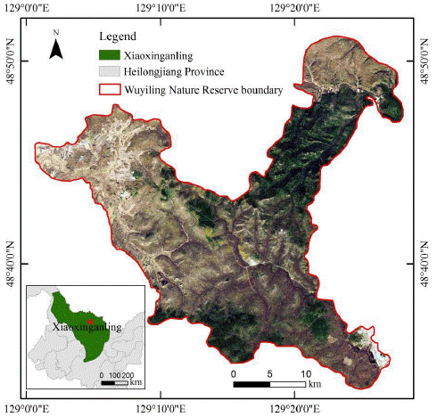
The images used in this study is located in Wuyiling national nature reserve, Geographic coordinates are 129°00'E-129°28'E,48°33'N-48°50'N, east of the Xiaoxing'an mountains peak, northeast Heilongjiang Province. Hyperspectral images can make up for the lack of distinguishing ground object information in wide-band remote sensing images (Yan, 2008). However, due to the low spatial resolution of hj-1a data source (100 m), by fusion with the high-resolution landsat-8 OLI full-color image (15 m), the spatial resolution of the data source was improved, so as to obtain more features of ground objects (Table 1). The auxiliary data include the vector boundary map of the research area and the measured data of the field sampling points.
Table 1 Data sources used in the study area
| Time | Satellite designation | Sensor type |
|---|---|---|
| 20150719 | HJ-1A | HSI |
| 20150815 | Landsat-8 | OLI |
Data preprocessing
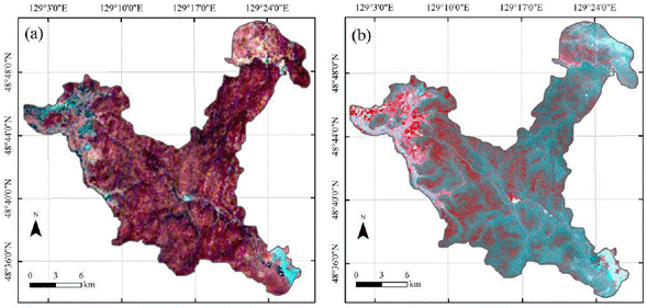
HJ-1A data. was preprocessed with ENVI5.3 software, which HJ-1A /1BTools tool is used to convert the data format, after calculating the signal to noise ratio of each band image, remove the first 20 bands with low signal to noise ratio. Due to the existence of severe tilted stripes and Bad lines in HSI data, the Replace Bad Line function is used to repair Bad lines and the global method is used to remove image stripes. Radiation calibration of HSI secondary data has been carried out, and FLAASH atmospheric correction is still needed, and Landsat8 OLI images of the same period were taken as reference, Select GCPS: Image to Image tool was used for geometric precision correction, finally, the image is Mosaic and cropped (Fig. 2).
Fusion methods
Due to the large number of bands in HJ-1A hyperspectral image, three fusion methods with unlimited band number are adopted in this paper for fusion operation.
(1) Principal component (PC) transform
PC transform is a multidimensional orthogonal linear transformation based on statistical characteristics (Ma, Feng, He, & Zhang, 2007). It concentrates the common information of multi-band images into the first principal component, while the unique spectral information that does not overlap with any other bands is put into other principal components, Then, the panchromatic band data are stretched to have the same mean and variance with the first principal component, and which are used to replace the first principal component for principal component inverse transformation to restore to the original space and generate multi-band fusion images with high spatial resolution.
(2) Gram Schimdt (GS) transform
GS transformation is essentially a phase recovery algorithm (Ma & Wang, 2016). The main steps of the algorithm are as follows: (1) Use the multi-spectral image with low spatial resolution to generate simulated panchromatic image with low spatial resolution; (2) The simulated image (as the first band) is superimposed on the multi-spectral image, and the reconstructed multi-spectral image is carried out GS positive transformation; (3) replace the first component of GS transform with high-resolution panchromatic image, then which was carried out GS inverse transformation on the multi-spectral image to get the final fusion image.
(3) Nearest neighbor diffusion (NND) algorithm
NND algorithm was proposed by Sun, Chen and David (2014). The main theory is that the new spectrum of high-resolution fusion images can be expressed as the weight combination of adjacent hyperpixel spectra of current pixels in low-resolution multispectral images. The fusion method based on nearest neighbor spreading can maintain accurate spectral information of multi-spectral images identified by spatial features, and is applicable to the application of accurate spectral information other than traditional visual inspection (Ocalan, Erdogan, Tunalioglu, & Durdag, 2016; Gao, 2015).
Evaluation methods
In this paper, four evaluation indexes including mean, standard deviation, information entropy and average gradient were selected to objectively evaluate the fusion image from the perspectives of image brightness, clarity and information content (Fusun, Saygin, Mustafa, & Filiz, 2017).
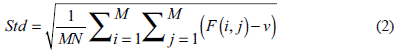
Mean, which is the gray mean value of pixels in remote sensing images, which can be expressed as:
Where: M, N are the width and height of the image respectively; F(i,j) is the DN value function of all pixels in the fusion image; i and j represent the row and column Numbers of raster cells.
Standard deviation, which reflects the dispersion of DN values of all pixels and their DN means, can be used to evaluate the brightness of images. The higher the value, the more information the image contains. The specific formula is:
Where: v is mean, M, N are the number of rows and columns of the image; F(i,j) is the DN value function of all pixels in the fusion image; i and j represent the row and column Numbers of raster cells.
Average gradient, with the ability to sensitively reflect the image contrast to small details and texture transformation expression. The larger the average gradient value is, the more layers the image has and the clearer the image will be. The expression is:
Where: M, N are the number of rows and columns of the image; ∆I x , ∆I y are the first-order difference of x direction and y direction, respectively; i, j are the line and column number of each pixel in the image of the same band.
Information entropy, an evaluation index of spatial detail information based on information quantity, reflects the amount of image information quantity. The larger the value is, the larger the information content of the fusion image be. The expression is:
Where: L represents the overall gray scale series in images; P i . represents the probability of gray value of pixels in images.
Results and analysis
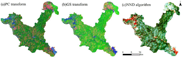
The PCA transform, GS transform and NND algorithm results of HJ-1A HIS image are shown in the figure (Fig. 3.)
Visual interpretation
It can be seen from the comparison between the fusion image and the original image that the fusion image maintains the spectral characteristics more greatly in terms of maintaining spectral information. PC fusion image and GS fusion image have moderate color contrast, and all kinds of ground objects in the fusion image show standard spectral detail features. Visually speaking, there is no significant difference in spectral features between the two fusion images; The color change of NND fusion image is serious, and spectral deformation of all kinds of ground objects has occurred, in which the construction land is green and the spectral deformation is serious. Sphagnum and its surroundings appear purplish, which is quite different from the original image.
It can be seen from the spatial information of the image that the fusion image is clearer and more distinguishable, with the same spatial resolution and clearer texture structure as the landsat-8 panchromatic image. In the NND fusion image, the texture of construction land is clearer, and the edges of ground objects are prominent, which makes it easier to identify. However, serious fuzzy phenomena appear at the boundaries of sphagnum and marsh, the fused image is not clear enough. The color of construction land in PC fusion image and GS fusion image is relatively bright and dazzling, and the vegetation features in GS fusion image are obvious.
Quantitative evaluation
According to the above quantitative evaluation indexes, with the support of ENVI/IDL8.5, The eigenvalues of fusion images obtained by the three fusion algorithms used in this study are extracted, and the calculated results are shown in Table 2.
Table 2 Fusion image evaluation index calculation results
| mean value | Standard deviation | Average gradient | Information entropy | |
|---|---|---|---|---|
| Original hyperspectral image | 115.498 | 77.508 | 4.392 | 4.158 |
| PC fusion image | 111.143 | 92.902 | 12.358 | 4.652 |
| GS fusion image | 117.078 | 81.412 | 14.542 | 4.647 |
| NND fusion image | 117.971 | 77.215 | 6.142 | 4.515 |
In terms of the brightness information of the image, the difference between the mean value of the fused image and the original image is relatively small. Descending Means of fusion image: NND fusion image > GS fusion image > PC fusion image. The results show that the brightness of GS fusion image is the closest to the original image, indicating that GS fusion image has certain advantages in maintaining brightness information.
From the aspect of image sharpness, average gradient can be used to evaluate the effect of improving sharpness in objective evaluation indexes. It can be seen from the table that the average gradient of GS fusion image is the largest, followed by PC fusion image, indicating that GS fusion image and PC fusion image have advantages in terms of sharpness.
In terms of the information content of the image, the standard deviation and information entropy of the fused image can evaluate the improvement of the information content. The standard deviation and information entropy of PC fusion image are better than the other two fusion images. The information content of PC fusion image is the largest, followed by GS fusion image and NND fusion image.
Spectral variation analysis
In hyperspectral images, the radiation information of each pixel in each band can be extracted into a continuous spectral curve, reflect the spectral characteristics of ground objects, and realize the fine classification of ground objects, which is the most significant advantage of hyperspectral images (Moon, Choi, Lee, & An, 2017; Adam, Mutanga, Rugege, 2010). If the spectral curve of fusion image is distorted, the spectral information also changes. Therefore, to evaluate which fusion method can retain the spectral information of the original image to the greatest extent, it is necessary to analyze the spectral curve variation degree of fusion images. From the fusion images and the original images, typical features of 9 ground objects samples, which concluded construction land, lakes, farmland, Sphagnum, Carex tato, Salix brachypoda, White birch, Pinus koraiensis and Spruce, were selected to calculate the average spectral curve (Fig. 4.).
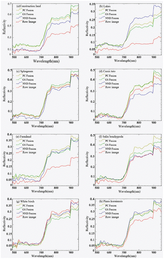
In the spectrum curve of construction land, the spectrum curve of PC, GS and NND fusion image is similar. Before 700 nm, the NND fusion image is lower than the original image spectrum curve, and after 720 nm, the spectrum curve of the three kinds of fusion image is higher than the original image. In comparison, the spectral fidelity of NND fusion image is better. In lake spectral curve, before 700nm, spectrum curves of three kinds of fusion image are almost the same, after 700 nm, spectrum curves of three kinds of fusion image are higher than the original image. It indicates that the spectral information of the water body of the three fusion images is seriously distorted, in which the change of the original spectral information by GS fusion is relatively small, while the change of the original spectral information by NND fusion is relatively large; The Sphagnum spectral curves of the three fusion images almost coincide with that of the original images, indicating that the fusion images have little influence on the Sphagnum spectra; The spectral curve of the Carex tato before and after fusion had the same trend before 700 nm, indicating that spectral fidelity was better. after 700 nm, The spectrum curve of NND fusion image is lower than that of the original image, while the spectrum curve of PC fusion image and GS fusion image is higher than that of the original image, and keep the same trend; The spectral curves of farmland before and after fusion, after 700 nm, the spectral curves of three fusion images and the original image presented significant differences and serious spectral deformation. The reflectance of the spectral curves of the three fusion images was much higher than that of the original image and show the same trend; The spectral curves of white birch, pinus koraiensis and spruce before and after fusion, the spectral curves of the three fusion images and the original images almost overlapped before 750 nm, indicating that the fusion images retained good spectral characteristics. After 750 nm, the original spectral curve of white birch was higher than that of the three fusion images, while the original spectral curve of pinus koraiensis and spruce was lower than that of the three fusion images, indicating that there was a certain degree of spectral deformation in the fused images.
Classification results and accuracy evaluation
In this study, the Spectral Angle Mapper (SAM) classification method with high accuracy was selected to extract the information of wetland types in Wuyiling National Nature Reserve. SAM is a hyperspectral classification algorithm designed based on the spectral shape characteristics of hyperspectral data. This algorithm has a simple design idea and does not require data compression of hyperspectral remote sensing data. It is a relatively mature classification algorithm in hyperspectral image classification. SAM classification processing is applied to fusion images of different methods (Fig. 5). Meanwhile, the accuracy of classification results is evaluated by using field sampling data in 2015 (Tables 3-5).
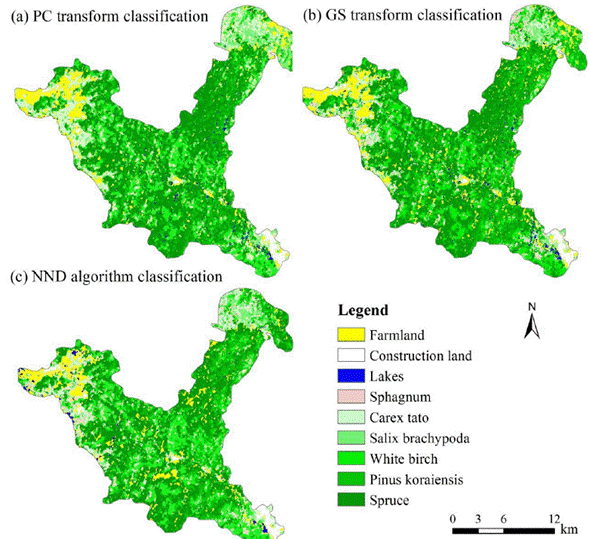
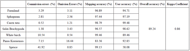
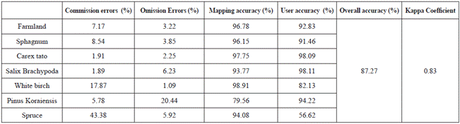
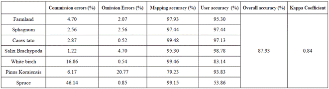
According to the classification results, SAM was used to classify the fusion image. The accuracy of PC fusion image classification was higher and that of GS fusion image classification was lower. Among them, the mapping accuracy of Pinus koraiensis is 79.23% to 83.56%, and that of spruce is 94.08% to 99.15%. There are often misclassification between Pinus koraiensis and spruce. In the commission errors, the values of spruce and white birch are relatively high. Among the three fusion images, the commission errors of spruce and white birch in PC fusion images are relatively low. In the Omission Errors, the values of Pinus koraiensis is larger, and the classification results of other ground objects are better because of the large difference in spatial details.
Conclusion and Discussion
In view of the low spatial resolution of hyperspectral remote sensing image of HJ-1A satellite, landsat-8 panchromatic image was applied to carry out fusion experiments on three fusion methods of maintaining image's band number, namely, PC transform, GS transform and NND algorithm, and the fusion results was evaluated. The main conclusions are as follows:
(1) Compared with the original image, the fusion image is clearer and more distinguishable. The three fusion images maintain the spectral characteristics to a large extent, among which PC fusion image and GS fusion image have moderate color contrast, while NND fusion image has serious color change. The texture of fusion image construction land is obvious, and the edges of construction land are prominent, while the edges of different vegetation types are seriously blurred. The high reflectivity of construction land in PC fusion image and GS fusion image makes it difficult to distinguish.GS image fusion significantly enhanced the vegetation characteristics. In conclusion, GS fusion image and PC fusion image have advantages in sharpness. PC fusion image contains the largest amount of information, followed by GS fusion image. GS fusion image has a better performance in brightness information.
(2) In the spectral variation analysis, except for the serious spectral information distortion of the lake, the spectral curves of other features are similar in the PC fusion image and the GS fusion image; The variation degree of spectrum curve in NND fusion result is slightly less than that of PC and GS fusion results; In a variety of typical ground objects, the spectral information of lake and farmland is seriously distorted in the near infrared band, and the spectral information of salix brachypoda, spruce and sphagnum is best preserved.
(3) The SAM was applied to extract typical vegetation types from fusion images, and the accuracy of classification results was evaluated. The optimal overall classification accuracy reached 89.24%, and the Kappa coefficient was 0.86. The classification accuracy of PC fusion image is the highest, and contains the largest amount of information; NND fusion image have certain advantages in spectral fidelity and higher classification accuracy. The classification accuracy of GS fusion image is relatively low.

