


 Inglés (pdf)
 Articulo en XML
 Referencias del artículo
 Enviar articulo por email
 Citado por SciELO
  Citado por Google
  Similares en
SciELO
Similares en
SciELO  Similares en Google
 Permalink
Introduction
Environment and development have become a common concern in today's world. Ecosystem is the link between environment and development. It not only meets the needs of material products and environmental services for human survival and development, but also plays an important role in maintaining global ecological balance and protecting biodiversity (Sylvestre et al., 2017). Wulingyuan World Natural Heritage Situated in the northwest of Hunan Province is famous for its unique quartz sandstone peak forest landform. Sandstone is a kind of rock formed by weathering, transporting, sedimentation and diagenesis. It has the characteristics of low strength, poor weathering resistance and little cementing material. It is the main part of the peak forest landform of Wulingyuan Scenic Area. Michael Crosser, president of the International Association of Geomorphologists, said at the opening ceremony that similar geomorphological features exist in the world, but the geomorphology of Zhangjiajie should be recognized by the world because it lacks such distinctive features and scale and integrates aesthetic feeling and scientific research value. Zhangjiajie, a sandstone landform, is very rare in China and even in the world, and its formation conditions are very harsh (Colgan et al., 2017). Therefore, in order to protect the ecological environment of the peak forest landform in Wulingyuan Scenic Area and maintain the integrity and stability of the peak forest landform, it is necessary to study the optimization method of the spatial structure characteristics of the peak forest landform in Wulingyuan Scenic Area.
At present, there are many studies on the peak forest landform of Wulingyuan Scenic Area in Zhangjiajie in China. Qi Chengjing and Fang Yingcai have visited Zhangjiajie for plant investigation and specimen collection. Zhang Zhicai and others have carried out research on the types of forest resources, community structure and distribution characteristics, and the function of ecosystem in the peak forest landform of Wulingyuan. Based on the research and discussion, the countermeasures and suggestions are put forward in the development planning, evaluation of ecological benefits and construction and development ideas of Peak-forest landform. Liang Mingzhong and others use spatial index and spatial statistical technology to describe the spatial attributes of Peak-forest landform and study the ecological characteristics of the spatial structure of Peak-forest landform. This paper studies the spatial structure characteristics of peak forest landform in Wulingyuan Scenic Area from three aspects: basic landform characteristics, surface morphology characteristics and geomorphological spatial pattern, and puts forward rational optimization methods to provide basis and reference for the ecological environment protection of Wulingyuan Scenic Area (Jiang, 2017).
Research areas and research methods
Survey of research areas
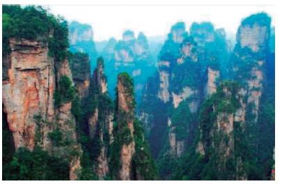
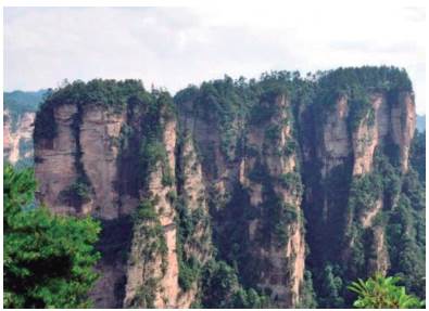
Wulingyuan is located at Eastern longitude 110°20'30"~110°41'15", Northern latitude29°16'25"~29°24'25". It is the junction of Zhangjiajie City in Northwest Hunan Province with Cili and Sangzhi Counties, with a square area of 369 km. It consists of four distinctive nature reserves: Zhangjiajie, Tianzishan, Suoxiyu and Yangjiajie. There are still Scenic Areas under development (Cole et al., 2018) in its periphery, such as Maoyan River, Jiudian Cave and Tianmen Mountain. Zhangjiajie is the first National Forest Park established in China (1982), so it is often called Wulingyuan Scenic Area by Zhangjiajie. Wulingyuan belongs to the national first-level protected area with an area of 53.5 square kilometers, the second-level protected area with an area of 55.5 square kilometers and the third-level protected area with an area of 203 square kilometers. There are fourteen 70 km tourist routes and more than 560 Scenic Areas (Zhang et al., 2017). Wulingyuan Scenic Area has ravines, high rock peaks, green trees and green vines, and flocks of animals and birds. It has the reputation of "the maze of nature" and "the world's first strange mountain". The landform of Wulingyuan Scenic Area belongs to the quartz sandstone peak forest landform. There are as many as 15,000 peaks in Wulingyuan. The peaks are distributed at an altitude of 500-1100 meters, ranging from tens of meters to 400 meters. This special landform is named "quartz sand pillar peak". As shown in Figure 1. The geomorphology of quartz sandstone peak forest is characterized by pure quality and stone thickness, quartz content is 75%-95%, and rock thickness is more than 520 meters. Wulingyuan has a complex terrain, mild climate, abundant rainfall, lush forests and primitive sub-Forest plant communities. Its forest coverage rate is 88%. There are 4 species of first-class protected plants and 19 species of second-class protected plants in Wulingyuan. There are 770 species of woody plants, of which Pinus Wuling is the only one in the region. In addition, there are Tertiary relics such as Davidia involucrata, Bole tree, Taxus chinensis, Taxus chinensis and Cephalotaxus angustifolia. Wulingyuan has 28 kinds of state-level protected animals. There are also famous giant salamander (doll fish) precious animals growing in Wulingyuan, as well as the first-level protected animals such as clouded leopard, leopard and other large beasts. In December 1992, Wulingyuan Scenic Area was listed on the World Natural Heritage List (Moreno et al., 2017) by UNESCO as a world famous tourist attraction.
The formation factors of peak-forest landform are as follows: firstly, the rock is quartz sandstone with pure quality, mainly quartz, thick layer, hard and stable, which is beneficial to natural sculpture and image enhancement; secondly, the occurrence of rock stratum is gentle, which increases the stability of rock, which provides the precondition for the formation of peak-forest landform; thirdly, two groups of sags are developed in rock stratum. Straight joints, generally 15 to 20 meters apart, provide the tectonic conditions for shaping the peak-forest landform. Under the background of intermittent uplift of regional neotectonic movement, the effects of flow erosion cutting, physical weathering, chemical weathering and biological root splitting and other external forces begin with rock joints, which widen the fissures gradually and evolve over time to form peak forest landform. Its characteristics are high, flat and steep (Klongvessa et al., 2018).
Experimental data
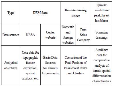
This experiment chooses 30 m grid resolution SRTM data, 1 m DOM data of high resolution remote sensing image, fast bird image data and world view data as main information sources, supplemented by 1:10,000 scale topographic map and other related data (Payo et al., 2017) from the completed National Geographic Database. In addition, the urban construction archives of the study area since 1990 were consulted, and a large number of data on social, economic and environmental changes (Li et al., 2018) were collected. The characteristics of the experimental data are shown in Table 1.
Extraction of topographic features of peak forest landforms based on tree node serialization
In the process of extracting the topographic features of Wulingyuan peak-forest, based on the theory of karst geomorphology, hydrology and mathematical statistics, using GIS spatial analysis and digital topographic analysis (Davies et al., 2018), using the combination of qualitative and quantitative analysis indicators, macro and micro analysis, and theoretical analysis. Combining with application validation, using multi-resolution DEM data as the basic data source, exploratory study on the geomorphological characteristics of sandstone peak forest was carried out by using tree theory (Hart, 2017).
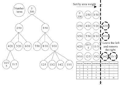
Because the number of nodes in each layer of the contour tree is different, the size of the chain structure transformed by the weight of the nodes in each layer according to the area represented by the contour is also different (Wang et al., 2019). Therefore, in the specific analysis and application, the tree node serialization method based on area weight is used to intercept the standard table structure with the same growth degree from the chain structure of different lengths, so that the classical mathematical statistics method can be used for analysis. The principle of tree node serialization is shown in Figure 2.
Determination of evaluation index for landscape pattern analysis
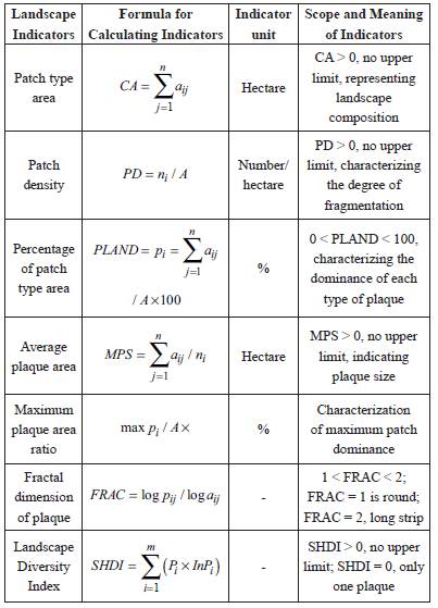
Landscape pattern analysis is the core content of landscape ecology. Quantitative analysis of spatial distribution characteristics of landscape components is the basis for further study of landscape function and dynamics (Goad & Korista, 2018). The impact of human activities on the landscape spatial pattern of Wulingyuan Peak Forest (Changqing et al., 2017) was measured by landscape patch type area, patch density, patch type area ratio, average patch area, maximum patch area ratio, patch fractal dimension and landscape diversity index. The landscape of Wulingyuan Peak Forest was studied separately. The landscape indices used in this study are shown in Table 2.
Results and optimization
Geomorphological characteristics of sandstone peak forest
Wulingyuan Peak-forest landform is situated on the upper part of the mountain body above 1000 meters above sea level. The edge of the mountain body or the valley zone develops best. Because of the cutting of the valley and the collapse of the rocks on the edge of the mountain body, the edge of the peak forest is generally a steep cliff. The rock wall is bounded by a clear unconformity of Caledonian crustal movement, and the strata are mainly composed of the Mesozoic and Paleozoic strata. The Upper Devonian Yuntaiguan Formation and Huangjiadun Formation are composed of littoral clastic rocks (Liang et al., 2017). The rocks are pure, thick, flat in base and well developed in vertical joints. The rocks are exposed in syncline outline, which reflects the special geological structure environment and basic conditions for the formation of sandstone peak forest landscapes. Running water erosion and gravity collapse, biochemical and physical weathering effects of external geological activities are indispensable external conditions for shaping Wulingyuan landform landscape. Therefore, the formation of sandstone peak forest landform is the result of the long-term interaction of internal and external geological gravity in a specific geological environment, coupled with the intermittent uplift and tilt of regional neotectonic movement, flow erosion and cutting, gravity, physical weathering, biochemistry and root splitting and other external forces. Peak forests are formed according to the complex natural evolution process, showing the characteristics of high, flat and steep walls. (Catania et al., 2017).
Basic morphological characteristics
Sandstone peak forest landform is a group landform, its basic form is cliff, peak (column), cliff channel, cliff lane.
(1) Cliff: Cliff, which is the largest and most spectacular landscape in the peak forest, can be divided into two cliffs, edge and interior, according to their different locations. The edge cliff is located at the edge of the peak forest area, which extends tens of kilometers intermittently. The local area is thousands of meters to more than ten kilometers long, tens of meters to more than one hundred meters high and 530m high. The wall is steep, like a copper wall and iron wall. The trend of cliff wall in peak-forest is controlled by two groups of joints. They are NW and NE. They are generally more than 100 meters wide and tens of meters high. Most of them are vertical cliffs with an inclination of more than 70°. All kinds of sedimentary phenomena on the wall are clearly visible.
(2) Peak (column): that is, the height of the peak forest is greater than the width of the stone peak and pillar, is the most basic morphological landscape of sandstone peak forest landform. The peak forest consists of thousands of single stone peaks and columns. Peak shape has square column, flat column, cone, bamboo shoot, peak wall, tower, rod, etc. According to the morphological characteristics of the peak body, it can be divided into the following combinations.
Square columnar peak forest includes square columnar and flat columnar peak forest, as shown in Figure 3. Peak forests are usually composed of several or dozens of columns with diameters ranging from several meters to tens of meters and height ranging from tens of meters to more than 100 meters. After the rock is cut by two groups of conjugate vertical joints, some surrounding rocks collapse under the action of gravity.
Conical-columnar peak forest: The peak column is conical in shape with fine upper and thick lower, usually tens of meters in height and several meters to tens of meters in diameter at the bottom. Its formation is related to lithology. Sandstone in the lower part of the peak body is dominant, and mudstone in the upper part is increased. It is formed by differential weathering due to the different degree of rock hardness and softness.
Bamboo shoot-like peak forest: the top of the peak is thin and thick, the base is connected, and the top is bamboo shoot-like. Generally, the height is more than several meters, and the scale is smaller than the conical peak forest. The rock is cut by dense vertical joints.
Peak Wall Peak Forest: Horizontal rock stratum is cut by vertical joints to form a cliff, side as a wall, is seen as a peak, wall direction is controlled by joint direction.
Hieroglyphic peaks: Most of them are single or solitary peaks, varying in size and height, such as tower, rod and column shapes. They have various shapes, such as deer, pipe, lotus flower, general, duck head, snake head, and so on. They are similar to human beings. One scene at a time, they are formed by different lithological weathering and rock collapse.
(3) Cliff groove: refers to the vertical groove landform landscape in which the depth and height of the peak forest are greater than the width, also known as vertical groove, formed by the collapse of rocks in two or several vertical joints. The cliff trough is usually tens of centimeters wide to several meters, with a horizontal depth of 1 m to several meters and a height of 10 m to tens of meters. Its width, height and orientation are related to the density, spacing and orientation of joints. It is a common micro-landform landscape in peak forest landform.
(4) Cliff alley: Horizontal roadway with narrow and deep shape is the result of the development of the depth of the cliff groove toward the horizontal direction. Its width is generally only 2-3 m, while its height and depth are tens of meters to more than 100 meters. The roadway wall is upright, very similar to a line of sky or a sky roadway.
In addition to the above types of morphology, there are also some small landscapes in peak-forest area. They are combined with peak forest, valley, waterfall, forest vegetation and exotic flowers and trees to form a gorgeous landscape, which is described as a fairyland on earth.
Analysis and comparison
Peak forest refers to the landscape composed of separated stone peaks or pillars, most commonly in Karst area, clastic rock area, granite area and Cheltenham Badland area are well developed, but far less developed than karst area. Wulingyuan sandstone peak forest belongs to clastic rock peak forest. Its characteristics are similar to karst peak forest and Cheltenham Badland landform, but there are also many obvious differences, as shown in Table 3.
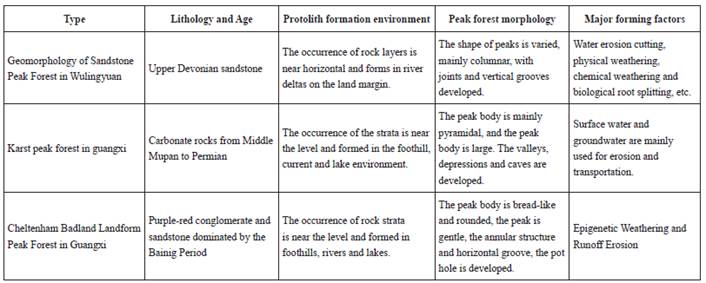
(1) Compared with karst peak forest. Karst peak forests in China are widely distributed in Guangxi, Guizhou and Eastern Yunnan. They are mainly pure and hard carbonate rocks of Devonian, Carboniferous and Permian with thickness of more than kilometers. They have been developed for a long time in hot and humid climates. The karst peak forest generally develops in the plain area or valley on the edge of peak cluster karst. It can be divided into three types: basin plain type, peak cluster valley type and edge slope valley type. Stone peaks in peak forests stand apart from each other and vary in density. In plain areas, solitary peaks are dominant. They are pyramidal in shape, partly conical or saddle in shape and below 150 m in height. After being dissolved by water solution, caves on the peaks develop and are known as caves without caves.
The main difference between Wuling Mountain sandstone peak forest and karst peak forest is that the lithological composition is completely different: the forming conditions of the two forests are different. The karst peak forest is mainly formed by water erosion and cave development, while the sandstone peak forest is mainly formed by flowing water erosion, physical weathering, chemical weathering and biological root splitting.
(2) Comparing with Cheltenham Badland landform. Cheltenham Badland landform in China is mainly distributed in Renhua of Guangdong, WuyiMountain of Fujian, Longhu Mountain of Jiangxi, Dajinhu of Fujian, YuntaiMountain of Henan, YuntaiMountain of Guangxi, LiangMountain of Hunan, and the most typical landform of Renhua of Guangdong is named Cheltenham Badland landform. The Cheltenham Badland geomorphic diagenesis age in southern China is mainly the red rock series of the White Seal Period. Its lithology is purple-red conglomerate, sandy conglomerate and coarse sandstone. The rock strata are nearly horizontally produced. The main bedding troughs, flat caves, frontal caves and rounded ridge peaks are formed by a variety of factors. Compared with Cheltenham Badland landform, Wulingyuan sandstone peak forest has similar lithology, color and Danya landform. The difference is that the formation conditions and morphological types are different. Sandstone peak forest rocks are fine clastic rocks with harder texture, strong weathering resistance and more developed Danya landform. Cheltenham Badland landform rocks have coarse grain size and weak weathering resistance. There are obvious differences between bedding troughs (caves), rounded ridges and steamed bread ridges and sandstone peak forests.
Analysis of peak cluster shape characteristics based on tree node serialization
Taking the peak forest landform research area of Wulingyuan Scenic Area as an example, the nodes of contour trees are serialized according to area weight. In the actual serialization process, the contour tree is constructed for the five geomorphic units of Wulingyuan Scenic Area: depression, stone peak, compound depression, peak forest and peak-depression combination. Only the first four nodes of each layer are intercepted, and the first node of each layer is recorded as the parent node. The first three nodes are sorted according to the size of the area. It is designated as the first child node, the second child node and the third child node. Because the contour trees constructed by simple shape (stone peak and depression) are single-branch trees, and the structure is simple, four nodes are truncated downward from the root node, and the root node is recorded as the parent node. According to the subordinate relationship between nodes, the first child node, the second child node and the third child node are recorded in turn. Finally, based on the order of area serialization, the roundness coefficient C and the compactness coefficient T of the parent node and the child node are calculated respectively, and the corresponding confidence interval diagrams of roundness coefficient and compactness coefficient 95% are drawn. The results are shown in Figures 4 and 5.
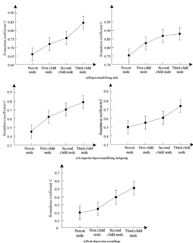
Figure 4 Comparisons of 95% confidence intervals for roundness coefficients of different landforms after serialization

Figure 5 Comparisons of 95% confidence intervals for compactness coefficients after serialization of different geomorphic units
From Figure 4 and 5, we can see that the roundness coefficient C of Wulingyuan peak forest landform gradually increases from parent node to child node, and the compactness coefficient T gradually decreases from parent node to child node. It shows that the shape of the sub-nodes is closer to the circle than that of the parent nodes in five different geomorphic units, whether roundness coefficient or compactness coefficient is used as a measure. For composite terrain (such as Fung Shek Group, composite depression, combination of peaks and depressions), the shape of the geomorphic units nested step by step in its interior tends to become circular gradually. Comparing the roundness and compactness coefficients of different geomorphological types, it can be found that the more complex the combination of landforms (such as the combination of peaks and depressions), the narrower the surface shape, the more complex the surface morphology. At the same time, because the outcrop of carbonate rocks is more obvious in the depression area, and most precipitation flows into the depression area, the karstification in the depression area is stronger than that in the Fung Shek area, and the surface of the depression area is more fragmented and fragmented, so the range of roundness coefficient and tightness coefficient in the depression area is larger than that in the Fung Shek area. It can be seen that the structure of contour tree can not only directly reflect the hierarchical nesting characteristics of peak cluster surface morphology, but also contain the related information of different levels of geomorphic units, so as to facilitate the analysis of the morphological characteristics of geomorphic units at different scales.
Geomorphological spatial pattern of sandstone peak forest
Change of vegetation landscape
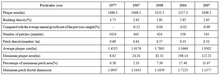
In the past 30 years, the vegetation in the study area has been growing and expanding. Before tourism development, as in other areas of the country, under the influence of grain policy, deforestation and deforestation were very serious. Except for the quartz sandstone peak forest landform, steep rock cliffs and some places with large slopes, most areas had reclaimed wasteland and few patches of vegetation around villages. Vegetation coverage is low, the change of landscape characteristics of vegetation cover in Wulingyuan Scenic Area is shown in Table 4.
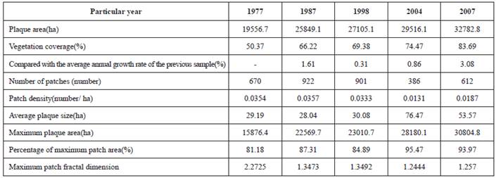
From the point of view of patch fragmentation degree, the degree of vegetation fragmentation is relatively low. There is little change from 1977 to 1987, the degree of vegetation fragmentation is slightly reduced from 1987 to 1998, the degree of fragmentation is obvious from 1998 to 2004, but the degree of vegetation fragmentation has increased from 2004 to 2007. From 1977 to 2007, the largest patch area increased steadily, but its proportion fluctuated, mainly due to the proportion of small vegetation patches in the core area and vegetation patches in the buffer area. The fractal dimension of the largest patch is higher, which is mainly due to the strong influence of human activities around the largest patch and the complex shape of the patch. The most notable one was 1998.
Architectural landscape change
Architectural landscape is the smallest landscape type in the study area, but it is the most profound and destructive landscape type of human activities. It is the disturbing landscape in the study area. The change of landscape characteristics is shown in Table 5.
In 1977, the largest area of architectural landscape was due to the fact that rural settlements were quite scattered and a large number of settlements were still in the core Scenic Area. By 1987, due to the improvement of production and living conditions, some residents moved spontaneously from the humble mountains to the relatively flat villages under the mountains. On the other hand, because Wulingyuan was listed as a National Forest Park and a national key Scenic Area, the protection of mountain forests was strengthened, which prompted farmers to move out of the mountains. Since 1987, the tourism industry has developed rapidly, bringing about the climax of reception construction. However, the government did not control the construction of reception facilities in an orderly way at that time, which led to blind development. A considerable part of the construction of reception facilities without any formalities is the fastest stage of the urbanization of heritage sites. In 1999, the local government demolished 2x10⁴ m2 illegal buildings. In 2001, the demolition of Scenic Areas was initiated and nearly 3.4x10⁵m2 of the core scenic buildings were demolished. Since 2004, the relocation of residents in the core area has been initiated, and the area of architectural landscape in the core Scenic Area is less year by year. From the perspective of the number and density of landscape patches, the number of patches increased nearly twice from 1977 to 1998, decreased rapidly in 2004, and then increased; the density of patches increased from 1977 to 1998, and then decreased and increased. The degree of fragmentation of architectural landscape increased from 1977 to 1998, then decreased due to demolition, and then increased significantly due to the pressure of tourism and local residents.
From 1977 to 2004, the proportion of the largest patches increased, indicating that the degree of urbanization agglomeration increased. However, after 2004, the patch was redesigned and the group development model was adopted. Natural patches were introduced into the patch, which reduced the maximum patch area and proportion.
Artificial landscape change
The artificial landscape in the study area is mainly land use which is strongly influenced by human activities rather than architectural forms, including paddy field, dry land, wasteland, artificial reconstructed waters, roads and other types. The overall characteristics of the artificial landscape in the study area are that the area decreases year by year, and the changes of landscape index characteristics are shown in Table 6.
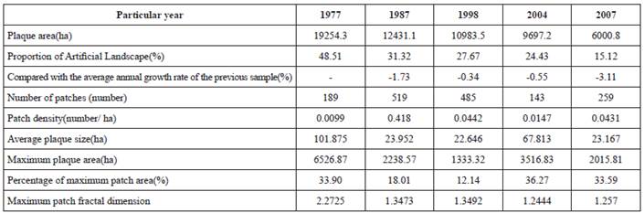
From 1977 to 1987, the artificial landscape decreased rapidly, accounting for only 31.32% of the total area in 1987. The main reason for the decrease was that some of the dry land in the gentle slope of mountain forests was able to restore forest vegetation, while some of the artificial landscapes were occupied by the marginal lowland buildings. From 1987 to 1998, there were fewer artificial landscapes, accounting for only 27.67% of the total area in 1998. The main reason for the decrease was the conversion of farmland to forest in the core Scenic Area and the further reduction of the peripheral artificial landscape area. From 1998 to 2004, there were only a few patches in the artificial landscape of the core Scenic Area, the decrease was most obvious. In 2004, the artificial landscape only accounted for 24.42%. From 2004 to 2007, the number of artificial landscapes in the buffer zone decreased significantly. The main reason is that some areas with poor farming conditions in the buffer zone have been restored to vegetation cover. In 2007, only 15.12% of the total artificial landscapes were restored to vegetation cover. From the perspective of patch density and average patch size, the trend of fragmentation of artificial landscape is quite obvious, and only in 1998-2004, it has been reduced. The main reason is that the artificial landscape is gradually eroded by vegetation patches, and the number of patches is increasing, which has become a landscape type gradually eroded in the study area.
Spatial structural feature optimization method
(1) Based on the principle of combination of centralization and decentralization, a spatial development model (Fang et al., 2018) for optimizing the overall pattern of peak forest landform in Wulingyuan Scenic Area is constructed according to local conditions. The research shows that the focus of the construction of peak forest landscape spatial structure in Wulingyuan Scenic Area is to optimize the overall spatial pattern of the landscape. There are fragmentation characteristics in the spatial structure of Fenglin landform, which has the advantage of constructing an overall structure optimization model based on the principle of combining centralization with decentralization.
(2) Designing landscape corridors of Wulingyuan Scenic Area at different scales and levels to give full play to the overall ecological function of the landscape. The holistic concept of "urban integration" and "suburban integration" is not only the basic concept of modern urban spatial structure planning, but also one of the basic principles of peak forest landscape spatial structure in Wulingyuan Scenic Area. High fragmentation is one of the main characteristics of the spatial pattern of peak forest landform in Wulingyuan Scenic Area, and it is also the main reason affecting the ecological function of peak forest landform. Therefore, corridor construction in Wulingyuan Scenic Area of different scales and grades should become the main task of landscape protection and construction.
(3) Strengthen the construction of landscape patches in key and sensitive areas. Wulingyuan peak forest Landform is a weak area in the construction and protection of spatial pattern. Therefore, Wulingyuan Scenic Area should not only increase the total amount of forest to balance the spatial distribution of forest landscape and improve the ecological quality of landscape, but also plan and build a large near-natural forest landscape patch in the peak forestland form area.
(4) Strictly protect artificial landscape patches and improve the quality of artificial landscape ecosystem. Large artificial landscape patches with high naturalness not only play a key role in maintaining the ecological environment quality and protecting the biodiversity of Scenic Areas, but also play an irreplaceable role in constructing the overall development model of structural optimization. It is necessary to carry out natural, ecological, diversified and characteristic transformation of artificial landscape ecosystem.
Discussions
The geomorphological characteristics of sandstone peak forest are mainly composed of thousands of stone peaks, pillars, vertical cliffs and grooves, and the main combination forms are columnar and conical peak forest. Under the background of intermittent uplift of regional neotectonic movement, the effects of flow erosion cutting, physical weathering, chemical weathering and biological root splitting and other external forces begin with rock joints, which widen the fissures gradually and form the peak forest landform over time. The peak forest landform evolved from the Devonian platform and experienced the platform. Local mountains, valleys, peaks and bushes, peak forests and other stages of development and evolution, will continue to develop in the future (Timbe et al., 2017).
Based on the topographic characteristics of the peak forest cluster with tree nodes, it is found that the peak forest cluster presents different degrees of self-similarity in different geomorphological types. Based on the node sequence method of area weight, the semi-structured contour data are serialized into a chain structure with uniform growth. Then the shape characteristics of peak clusters at different scales, angles and levels (Liu et al., 2018) are analyzed. The results show that in different geomorphological types, whether measured by roundness coefficient or compactness coefficient, the shape of sub-nodes is closer to the circle than that of parent nodes, and the shape of complex geomorphological units gradually turns into a circle from the outside to the inside.
The Wulingyuan Scenic Area has had a profound impact on the landscape in the past 30 years. Since the development of tourism in Wulingyuan in 1979, tourism and human activities of local residents have become an important factor affecting the landscape of the study area. The remote sensing images in the five periods of1977, 1987, 1998, 2004 and 2007 are representative of the landscape changes in the study area. 1977 reflects the landscape under the influence of strong farming activities before tourism development; 1987 represents the landscape under the influence of tourism industry just started; 1998 represents the inappropriate planning. Under management, tourism activities and local human activities have a profound impact on the landscape of the study area (warned by the World Heritage Committee in 1998); 2004 is the landscape of the study area after the implementation of the large demolition; 2007 is the landscape of the study area under the pressure of tourism development and the strong influence of local residents. The spatial pattern of sandstone peak forest landform in Wulingyuan Scenic Area from 1977 to 2007 was analyzed. The change of vegetation landscape showed that, despite the pressure of tourism, the vegetation coverage rate increased year by year, the fragmentation degree of patches decreased gradually, and the quality of vegetation patches improved gradually. Architectural landscape is the smallest landscape type in the study area, but it is the most profoundly impacted and destroyed landscape type by human activities. It is the disturbing landscape in Wulingyuan Scenic Area. Artificial landscape is mainly influenced by human activities rather than land use in architectural form, including paddy field, dry land, wasteland and artificial land, revamped waters, roads and other types (Kristensen et al., 2018). The overall feature of the artificial landscape in Wulingyuan Scenic Area is that the area decreases year by year.
Conclusions
Sandstone peak forest in Wulingyuan Scenic Area is located at the upper part of the mountain body at an elevation of 1000 meters. Its edge is a high cliff, forming a dangerous and exotic landscape. It has the basic forms of cliff, peak (column), cliff trough, cliff lane and so on. The peak forest is composed of thousands of stone peaks, pillars, vertical cliff walls, grooves, etc. The main combination forms are column and conical peak forest, which has important scientific research, popular science and tourism development value. The structure of contour tree can not only visually reflect the hierarchical nesting characteristics of the surface morphology of peak forest clusters, but also contain the relevant information of different levels of geomorphic units, so as to analyze the morphological characteristics of geomorphic units at different scales. The spatial pattern of peak forest landscape in Wulingyuan Scenic Area was analyzed by using various landscape indices. The vegetation landscape increased steadily, the artificial landscape decreased year by year, and the architectural landscape fluctuated, but tended to decrease as a whole. In order to provide better tourism resources and improve the ecological environment protection effect of Wulingyuan Scenic Area, the principles of combining centralization with decentralization, the design of scenic corridors and the strengthening of landscape patch construction were adopted to optimize the spatial structure characteristics of peak forest landform.

