


 Inglês (pdf)
 Artigo em XML
 Referências do artigo
 Enviar este artigo por email
 Citado por SciELO
  Citado por Google
  Similares em
SciELO
Similares em
SciELO  Similares em Google
 Permalink
Introduction
Shanxi province is known for its abundance in coal resources. With the continuous development of coal mining, the mined-out area resulting from coal mining now accounts for 98.6% of the total mined-out area in Shanxi and this helps the formation of mining landslide. Therefore, more and more researchers attach importance to the study of deformation features of the destabilized slope during underground mining and the relevant preventive measures so as to minimize the losses incurred by similar problems. To achieve this goal, we need to have a more precise and comprehensive understanding of the slope during underground mining. Researchers have tried in many different perspectives to do an in-depth study on it, such as inducing factors, formation mechanism, deformation mechanism, stability analysis, etc. Yang & Huang (1999) used elastic-plastic finite element analysis to discuss the changing patterns of stress field and displacement field induced by underground coal extraction, and he put forward the geological pattern for the deformation mechanism of the slope during extraction; Song & Nie (2003) discussed the changing pattern of the slope by analyzing different combinations of the directions of underground mining and the structural types of the rock mass of the slope; Fan (2006) made an in-depth analysis on the process of deformation damage at the mined-out side-slope and summarized the evaluation steps, key points, etc. of the loess side-slope. Chen et al. (2008) used the software Geo-Slope in their study of the relationship between engineering geological condition and stability of the mined-out side-slope, and then put forward some measures to deal with a landslide. Gao et al. (2009) used the software FLAC3D to evaluate the damage to side-slope and the stability of the management results to counteract it. Shangguan & Wang (2009) applied limit equilibrium theory and finite difference numerical simulation method to the analysis of mined-out landslide and concluded the intrinsic mechanism of it. Taking the Fengmaoding slope typically found in the mountainous areas of central Shanxi province as its studying object, this paper adopted the method of numerical simulation to analyze the effects of the fault in controlling the deformation features of the destabilized slope during underground mining by adopting the method of numerical simulation from these perspectives including displacement, stress, strain, etc. under different circumstances (the faulted and unfaulted) so as to provide guidance for the future studies about landslides of the same type and give preventive proposals for reference.
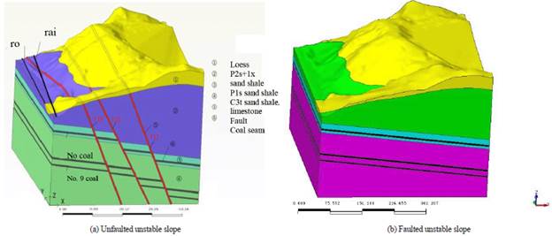
The slope deformation development characteristics after underground coal mining are given. The lithology of Fengmaoding slope consists of soil and bedrock. The slope is about 140m long and 210m wide. The area is 29,400m2 and its volume is 58,8000m3. The principal axis direction of the slope is 318°, and the average slope is 50°. The front elevation of the slope is 1036m and the rear elevation is 1146m. The slope appears irregular semicircle in the plane, and a convex on the section approximately, as shown in Figure 1.
The field investigation suggests that the slope deformation-failure is presented as a ground fissure. 25 fissures are found, most of them are distributed on the mountaintop. Usually, they are tensing fissures and strike from north-east to south-west, which is presented as a linear distribution along the mined-out area. The width of these fissures is different, which is usually about 2cm. And some fissures are buried by diluvium (The Fengmaoding unstable geological body of survey report in Luyukou, 2009; Lv et al., 2011).
Engineering geological conditions in the research area
Geographic and geomorphic conditions
Located on the east side of the central part of Luliang ridge, the research area is a mid-low mountainous area with loess on its top and bedrock exposed on both sides of the river valley at its foot. The north-west part of the slope is standing next to the Lion riverbed. The elevation in the highest point of the Fengmaoding is 1145m, while the beach of the western Fenhe river is only 1030m in elevation. The maximum relative relief is about 115m. As to the maximum slope steepness, the bedrock region is 48°, the loess region is 60°and the average steepness is 35°. The erosion gullies divide the north-east part and the south-west part of the slope.
The railway special line, county road and Lion riverbed lie in the western part of the research area.
Formation lithology conditions
The research area is situated in the north-west corner of Xishan coalfield. The exposure strata are lower Permian Shanxi formation, lower Permian lower Shihezi formation, higher Permian higher Shihezi formation in Permian system; Neogene upper Pliocene Baode formation, quaternary middle Pleistocene Lishi formation, upper epipleistocene Malan formation, and Holocene stratum. The former three strata mainly exist on both sides of the branches of the Lion river, while the rest mainly spread at the mountain ridges and riverbed regions (Mese & Tutuncu, 1997).
Geological structure condition
Located at the north-west edge of Taiyuan Xishan coalfield, the area is a part of graben formed by Lion River-Malan syncline fold belt of Taiyuan Xishan syncline subsidiary fold, subsidiary fold in Haojiagou north syncline, Jiulongta fault (F17) and Hongyazi fault (F49).
The anticline is located in western research area, whose west wing is the strata of Shanxi formation and lower Shihezi formation in the lower Permian system. The stratigraphic dip generally ranges from 5°-9°, and some can reach 14°. The surface of the east wing of the anticline is largely covered by Neogene and Quaternary strata, underlying is the strata of Shanxi formation and lower Shihezi formation in the lower Permian system. Both wings are substantially symmetric. The axial direction of north-north-east extends close to a line, and the extended length is more than 1500m pitching toward the south.
According to the surface investigation and analysis of the relevant geological data, three normal faults (F17, F19, and F20) are found in the research area whose strike is almost parallel with the Lion River. These faults lean south-east with a larger dip. The fault displacements range from 5m to 40m combined into steps.
F17 normal fault: the fault strikes to north-east of 30°, and leans to the south-east with an angle of inclination of 65°. The fault displacement is about 40m.
F19 normal fault: the fault is about 130 m from the west side of F17 normal fault. It strikes to the north-east of 25° and leans to the south-east with an angle of inclination of 65°. Its fault displacement is about 6m, and the extended length is about 900m.
F20 normal fault: the fault is about 20 m from the west of F17. It strikes to the north-west of 31° and leans to the south-east with 60°. Its fault throw is about 20m, and the extended length is about 350m.
Coal mining activities
The main coal-bearing stratum in the research area distributes at the Taiyuan Formation in the upper carboniferous system and Shanxi formation of the lower Permian system. The research area mines the No.2+3 coal seam, and the working face is arranged in a longwall face along strike when mining. The strike length is 630m, and the inclined length is 120m. the caving method and high-grade conventional mining are used, and the former is applied for managing the roof. The mined-out area is right below the slope top and its area is 24,000 m2.
Calculation principle and the establishment of model
Principle
When the finite element technique used by Midas GTS NX is applied for stability analysis, the initial stress field of the mechanical model is calculated, and then the strength reduction method is used to reduce the strength of rock-soil mass continuously in order to reach the non-convergence state. At last, the corresponding fracture point and fracture plane will be found according to the stress field distribution of the research object. The model should comply with the Mohr-Coulomb Criterion. The formula is (Irwin, 1977):
δ1: the maximum principal stress;
δ3: the minimum principal stress;
C: cohesive force of the rock-soil mass;
φ: internal friction angle.
Establishing a finite element model
Establishing the model with a width of 400m (in X direction), a length of 470m (in Y direction), a base elevation of 850m at the lower boundary, and the maximum elevation of about 1170m from upper boundary to the surface by using MIDAS/GTS numerical simulation software based on the actual slope topography. And two kinds of geologic models (the faulted and unfaulted) are established to analyze the effect of the fault on the slope body, as shown in Figure 1.
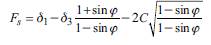
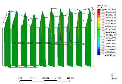
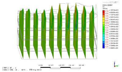
The division of mesh and the establishment of a three-dimensional finite element mesh calculation model for the unstable slope of Fengmaoding are based on the 3 principles. First, it should be able to reflect the geological features of unstable slopes and the underlying mined-out area of Fengmaoding. The unit block in the fault area, the mined-out area, and the surface, etc. should be subdivided to ensure the calculation model's ability in showing the true geometrical features of the rock mass. Then ensure the consistency of the calculation results for stress, displacement, during the numerical calculation.
Third, considering the limits for processing capability and the memory size of computers, the unit size should fit for the calculation program to process. This model has more than 70 thousand units. Whereby, the mesh division of key areas including loess on the earth surface, the F19, F20, and F17 faults, No.2-4 coal seam, mined-out area and No.8, No.9 coal seam, is shown in Figure 2.
Analysis of numerical simulation results
Comparative analysis of the whole displacement vector field
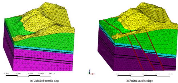
Faulted condition: The X directions of the foot in front of the slope and the F20 fault footwall (railway and road included) are mainly negative, manifested as the surface is extruding by displacing towards free face and the slope is deforming outward (see Figure 3); The X directions of F20 fault hanging wall and F17 fault footwall are mainly positive, showing that rock-soil mass is displacing towards mined-out areas and the slope is deforming inward as a result of the mining of coal seam (see Figure 3-a). The complex Y displacement vector field is controlled by the subsidence of mountain mass towards mined-out areas, showing that the rock-soil mass on both sides of the mined-out areas is displacing towards mined-out areas (see figure 3-b). The displacement vector field in the Z direction is relatively simple, mainly showing a feature of subsidence, and the largest subsidence displacement value of the mountaintop is in the Z direction as a result of the mining of coal seam. Note that there are red arrows on some parts of the mountainside over the railway, which indicate that the displacement field is uplifting. And it is consistent with the actual deformation features of displacement (see figure 3-c).
Unfaulted condition: The surface of the mountain slope is displacing horizontally in the positive X direction which is affected by mining subsidence, and the magnitude of displacement value in the direction deviating from the railway at top of the slope is about 0.03m, which is a large value. While the magnitude of displacement value at the mountainside and at the foot of the mountain is about 0.01m. And the magnitude of displacement value at the foot of the mountain is about 0.006m, which is smaller than the magnitude of displacement value at the mountainside. The soil mass of the steep local part of the slope shoulder is displacing in a negative direction in response to its own gravity, i.e. the soil mass is displacing toward the free face of the slope mass, and the magnitude of displacement value is about -0.01m. From the simulation calculation result, we can see that the existence of fault has a significant impact on the displacement direction in the X direction of surface and the magnitude of displacement value (see Figure 4-a).
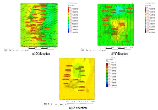
The whole magnitude of displacement value in the X direction of the surface is relatively small. The magnitude of displacement value at road and railway is about 0.001~0.005m, the magnitude of displacement value at the mountaintop is about 0.01~0.03m. The positive displacement in the Y direction is predominant; however, the displacement in some local areas is negative under the control of the topographic condition. The existence of fault has little impact on the displacement direction in the Y direction of the surface and the magnitude of displacement value based on the simulation calculation result (see figure 4-b).
The displacement in the Z direction of the surface is mainly subsided. The magnitude of subsidence displacement value at the top of the slope is about -0.2m, which is large. The vertical subsidence displacement value at mountainside and foot is relatively small, whose magnitude of subsidence displacement value is about -0.1m. And the magnitude of subsidence displacement value at road and railway is about -0.001m~-0.002m, which is small. The existence of fault under the control of the fault plane has a significant effect on the magnitude of subsidence displacement value in the Z direction of the surface judging from the calculation result (see figure 4-c).
Analysis of deformation of different sections in the Y direction
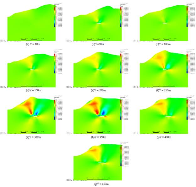
Existence of fault: Cutting the section in different positions in Y direction (Y=10m, 50m, 100m, 150m, 200m, 250m, 300m, 350m, 400m, 450m, 500m, 550m), as shown in figure 5. The X displacements of different sections are shown in figure 6 and the Z displacements are shown in Figure 7.
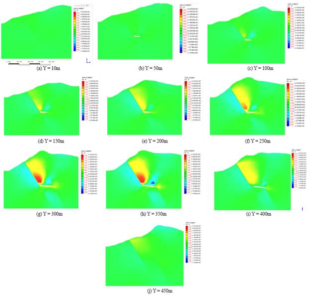
As shown in Figure 7, the displacement varies in different positions because of the mined-out area resulting from the excavation of coal seam. As shown in section Y = 10m, the relatively uniform X displacement map indicates the displacement changes little.
With the excavation of coal seam, as shown in section Y = 100m, Y = 150m, the F20 fault hanging wall in the position near the mined-out area begins to make a large positive displacement in X direction (the yellow); the F17 fault footwall is making a large negative displacement in X direction toward mined-out area (the light green).
In the maximum coal-mining position, as shown in section Y = 350m, Y = 300m, the largest displacements are the positive displacement in the X direction along the F20 fault in the F20 fault hanging wall (the red), and the negative displacement toward the mined-out area in F17 fault footwall (the blue). Meanwhile, the rock mass in the F20 fault footwall is making a relatively large negative displacement, shown as the displacement toward railway and road.
Though coal seam will not exist in the north of the mined-out area, there is still displacement in X direction affected by the mined-out area, such as the section Y=450m.
The displacement maps of different sections in X-direction indicate that big displacements in X direction basically occur on both sides of the F20 fault, with the hanging wall of F20 having displacement in positive direction (red) and the footwall having displacement in negative direction (green), showing that F20 is an important controlling factor to prevent the mountain from extruding to the free face.
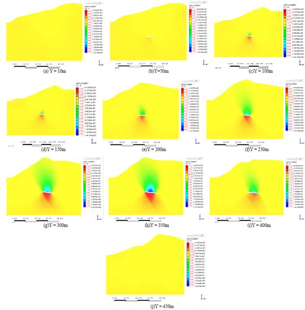
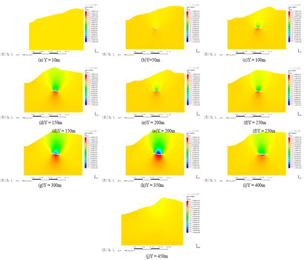
As shown in Figure 7, mined-out areas are formed due to the coal mining, and the displacements are different due to different locations of the mined-out areas. The displacement maps of the sections Y=10m and Y=450m on Z direction are uniform, which means the changes of their displacements are small.
For the parts near the mined-out area, such as section Y=100m and section Y=150m, the roof of the mined void has negative-direction displacement in the Z direction (green), with a manifestation of sinking, the base of the mined-out area has positive-direction displacement in the Z direction (red), with the manifestation of swelling.
For the biggest coal mining area, such as the sections Y=350m and Y=300m, the roof and the base of the mined void have the biggest displacement in the Z direction, with the roof sinking up to 1.44m and the base swelling up to 0.44m.
It indicates that all the big displacement changes occur in the hanging wall of F20, and the displacement of the rock mass is small in the footwall of the F20 fault (yellow), so F20 is an important controlling factor to prevent the mountain body from having subsidence displacement.
Unfaulted condition: Cutting the section in different positions in Y direction(Y=10m, 50m, 100m, 150m, 200m, 250m, 300m, 350m, 400m, 450m, 500m, 550m), as shown in Figure 8. Displacements of different sections are generated in X direction (see Figure 9) and Z direction (see Figure 10) respectively.
As shown in Figure 9, Y=10m in the X direction is uniform, which means the displacement change is small.
The part near the mined-out area forms the mined-out area, Y=100m, and Y=150m, the positive direction displacement happens. Comparing to the faulted condition, the displacement happens only affected by the mined-out area.
At the center of the mined-out area, such as the sections Y=350m and Y=300m, the positive direction displacement in the X direction is the biggest. As section Y=450m, the farther the distance to the center of the mined-out area, the smaller the displacement in the X-direction.
It's showing that the fault is an important controlling factor to prevent the mountain from extruding to the free face.
As shown in Figure 10, in the Z direction, the roof of the mined void has negative-direction displacement, with the manifestation of sinking, the base of the mined void has positive-direction displacement, with the manifestation of swelling. Y=350m and Y=300m, Comparing to the faulted condition, the fault controls the displacement border of the east side and the west side.
Conclusion
From the numerical simulation results, the characteristics of earth surface displacement in the mountaintop are mainly sinking, in the mountainside and at the foot of the mountain are mainly extruding outside dislocation and swelling deformation, in accordance with deformation characteristics on the actual earth surface. At the mountainside and the foot of the mountain to the west of the F20 fault, including the railway and road, the slope deformation is mainly the displacement in the X direction, with the manifestation of extruding outwards the free face and outward deformation of the slop, i.e. the horizontal deformation - swelling belt. At the mountainside and the mountaintop to the east of the F20 fault, the deformation of the slope is mainly downward displacement in Z direction, and the displacement of the rock-soil mass on the mountaintop is towards the mined-out area, with strong sinking deformation; the horizontal displacement characteristic is displacement in reverse direction to the free face and inward deformation of the slope, i.e. the horizontal deformation - sinking belt.
Regarding the Fengmaoding slope, geological and numerical models of underground mining condition are established, and the destruction and deformation processes of the slope with and without fault are given through simulation, by which we can draw the opinion that: under the condition of underground mining, the slope destruction deformation stress and strain distribution range and degree without fault are smaller than that with fault, i.e. underground mined-out area of a certain size is the main factor affecting slope stability, if fault exists in the slope, the destruction deformation of that unstable slope will further increase.

