


 Inglés (pdf)
 Articulo en XML
 Referencias del artículo
 Enviar articulo por email
 Citado por SciELO
  Citado por Google
  Similares en
SciELO
Similares en
SciELO  Similares en Google
 Permalink
Introduction
China has a vast territory, and there are great differences in the historical basis, natural environment, and economic development of different regions. Therefore, the trend of urban-rural interaction development in different geomorphic types of regions is also different (Zhang & Fan, 2017). Geomorphology is the undulating form of the lithospheric surface, and it is also an integral part of the natural geographical elements. In the evolution of urban and rural spatial form, on the one hand, geomorphology directly or indirectly acts on the development and expansion of urban and rural space, causing different responses and changes (Aumaître et al., 2017). On the other hand, geomorphology is the main place for energy exchange and transformation between urban and rural space and other elements and becomes the basis for the development of urban and rural space. Moreover, geomorphology itself has undergone profound changes under the influence of other elements, including urban and rural spatial expansion (Samadzadegan et al., 2017). In a word, landform and urban-rural space interact and promote each other, making the whole living environment change constantly. Correctly measuring the spatial distribution characteristics and optimizing the layout of urban-rural interactive development level is the premise of taking effective measures to coordinate urban-rural relations and narrow the gap between urban and rural areas. It is also the basis of choosing a reasonable model of urban-rural development and formulating optimal countermeasures for urban-rural interactive development in various regions.
Many scholars at home and abroad have carried out relevant studies on the spatial distribution characteristics of urban and rural areas in different geomorphic regions. Under the background of rapid urbanization, American scholars Pak and Brecko analyzed the impact of land use structure change, population size, and industrial structure adjustment on the development of urban and rural settlements in suburbs. Scholar Liu Xiantao studied the influence of topography, roads, and rivers on the spatial distribution characteristics of urban and rural settlements by using the method of CV value of the Voronoi map. It was shown that topography was the dominant factor affecting the spatial distribution of urban and rural settlements, while road traffic was the second factor affecting the spatial distribution of urban and rural settlements. Zhang Xia, a scholar, used spatial analysis and landscape index analysis to analyze the spatial distribution pattern of urban and rural settlements in hilly areas of Chongqing and its influencing factors. It was concluded that there were many urban and rural settlements in Hilly areas, but the scale of urban and rural settlements was generally small. The concentration of spatial distribution was low, and with the increase of terrain gradient, the area and average scale of urban and rural settlement land showed a relatively decreasing trend. Therefore, topography was the most direct factor affecting the distribution pattern of urban and rural settlements, which restricted the land use, scale, shape, and distribution characteristics of urban and rural settlements (Li et al., 2017).
Studying the spatial distribution characteristics and optimization of urban and rural areas will help to understand the spatial distribution law of urban and rural interactive development in an all-round way and provide a decision-making basis for promoting urban and rural interactive development in different regions. Based on the relationship between landform types and urban-rural development, this paper focuses on the spatial distribution characteristics of urban and rural areas in Loess and karst landform regions, compares the spatial distribution characteristics of urban and rural areas under different landform types, and puts forward corresponding optimization measures. Taking Jinghe River Basin as a typical area of loess landform type, this paper uses GIS and related statistical analysis software to superimpose and analyze the terrain and landform, urban and rural patches of Jinghe River Basin, summarizes three basic urban and rural types: river channel type, plateau type, and loess terrace prototype, and quantitatively studies the spatial distribution pattern of urban and rural areas in Jinghe River Basin, according to the suitable index of human settlement environment and life span of Jinghe River Basin. From the perspective of spatial distribution characteristics of eco-spatial environment, social and economic development status, conforming to the future needs of coordinated development of environment and economy, and establishing eco-friendly "low-carbon" urban-rural system spatial structure, this paper elaborates the optimization of urban-rural spatial distribution characteristics in loess landform type regions. Taking Guangnan County of Yunnan Province as a typical karst landform, this paper uses DEM module of ArcGIS software to analyze the basic characteristics of the spatial distribution of urban and rural settlements in Guangnan County of Yunnan Province and explores the influence of natural factors on the spatial distribution of urban and rural settlements in karst mountain areas, so as to provide a basis for optimizing the pattern of urban and rural settlements in karst landform type regions.
Material and Methods
Overview of Loess Geomorphology Research Area
Located in the north and west of China, the Loess Plateau covers a total area of 642,000 km2, of which 454,000 km2 is the most serious area of soil erosion and the most fragile ecological environment in China and even in the world. 80% of villages and towns in the Loess Plateau are located in small watersheds or related to small watersheds, and nearly 60% of the population live in them. The contradiction between the fragile ecological environment and the rapid development of urbanization in the Loess Plateau area, the contradiction between the comprehensive management of soil and water conservation ecological environment and the lagging concept of architecture discipline, gave birth to the concept of ecological living environment (Lu et al., 2017).
Jinghe River is the largest tributary of Weihe River, the first tributary of the Yellow River. It originated at the eastern foot of Liupan Mountain in Ningxia. It has successively formed radial water systems, such as Namalian River, Puhe River, and Heihe River, and injected the Weihe River near Chenjiatan, Gaoling County of Shaanxi Province. The total area of the basin is 46538 square kilometers. Due to the cutting of the Jinghe River and its tributaries, the Jinghe River Basin has formed four landforms: Loess Plateau-gully area, Loess hilly-gully area, Loess rocky mountain area, and Loess terrace plain area. Among them, the most representative is the Loess plateau-gully landscape in the central part of the Jinghe River Basin and the Loess hilly-gully landscape in the northern part of the Jinghe River Basin (Yasuhara et al., 2017). Therefore, the spatial distribution of urban and rural areas in the Jinghe River Basin on the Loess Plateau has unique regional characteristics. Jinghe River Basin is one of the most densely populated areas in the Loess Plateau, and the whole region contains four basic types of landforms in the Loess Plateau. It is also the main area for the construction of human settlements and the prevention of ecological damage and environmental pollution in the Loess Plateau (Nematollahi et al., 2018).
Landform Characteristics of Loess
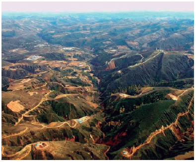
The surface of the Jinghe River Basin decreases gradually from northwest to southeast. The ground elevation is mainly between 1000 and 1600 meters above sea level. The vast area of the Jinghe River Basin is the Loess geomorphic area. The loess layer is deep, forming a typical loess layer profile (Mori, 2018). Because of the cutting of the Jinghe River and its tributaries, the landform landscape of the Loess with the source-gully alternation is shown in Figure 1.
Research Method of Spatial Distribution
In this paper, based on the human settlements environment assessment index of Jinghe River Basin, combined with the overall goal of the development of Jinghe River Basin, the knowledge of ecology, geography, human settlements environment, and other related disciplines are applied, the elements of future traffic planning, industrial layout, population development prediction, etc. are added to determine the idea and overall direction of regional planning. Using ArcGIS geographic information system software and ENVI remote sensing processing software, SPSS analysis and statistics software, and other methods and means, the development strategic planning program of the urban-rural system of Jinghe River Basin is formulated (Yang et al., 2018). The plan is based on ecological protection, which changes the traditional planning method that takes economic benefits as the main factor and ignores ecological benefits.
Survey of Karst Geomorphology Research Area
Research Area
Guangnan County is located in the southeastern part of Yunnan Province, at the junction of Yunnan, Guangxi, and Guizhou provinces, adjacent to Guangxi Zhuang Autonomous Region, northeastern Wenshan Prefecture. It is located at east longitude 104°31'- 105°39', and northern latitude 23°29'-24°28'. Its total land area is 7730.23 km2, including 11 townships and 166 administrative villages. It connects Funing County and Guangnan County to the east, Xichou County, and Malipo County to the south, Qiubei County and Inkshan County to the west, and Xilin County of Guangxi Zhuang Autonomous Region to the north. It is located in the northeast of the Karst Plateau in southeastern Yunnan, the terrain is high in the north and low in the south. The highest elevation point is barley land in the southwest, with an elevation of 2035 m. The lowest point is in the Xiyang River area of Banbeng Township, with an elevation of 480 m. In the north, eroded low mountains, low-medium mountains, and mid-mountains are the main areas of potential rocky desertification; in the south, karst areas are serious rocky desertification, densely covered with karst rocks, mostly carbonate rocks, with thousands of karst landforms (Külköylüoğlu et al., 2017). The study area is a sub-hot plateau monsoon climate with an average annual temperature of 16.6°C. At the end of 2011, the total population of Guangnan County was 661.07 million, of which 660.784 million people were agricultural, accounting for 99.96% of the total population, which is a typical agricultural-dominated region. The county's GDP is 545.5814 million yuan, per capita GDP is 824.54 yuan, and ethnic minorities are 406.39 million, accounting for 61.47% of the total population, which is a typical ethnic minority region. The per capita GDP is lower than the average level of the whole province, and the economic development is relatively backward. It is a key poverty alleviation County in Yunnan Province. Influenced by karst landforms, topography, rivers, highways, economic development level, ethnic minorities, and other factors, there is spatial differentiation in the distribution of urban and rural settlements (Zhiqiang et al., 2017).
Research Method of Spatial Distribution
Using DEM module of ArcGIS software, the distribution characteristics of urban and rural settlements in different areas of karst landform are analyzed by dividing the elevation and slope of Guangnan County (Dai et al., 2017), to explore the distribution and development trend of urban and rural settlements hidden behind the image, and to provide a research basis for further exploring the formation mechanism and historical evolution of regional settlements of karst landform type. This paper provides a scientific basis for the optimization of the spatial distribution of urban and rural settlements in regional planning and hopes to provide theoretical guidance for the construction of new socialist urban and rural areas in the loess landform region (Devos et al., 2018).
Results
Spatial Distribution Characteristics and Optimal Layout of Urban and Rural Areas in Loess Landform Area
Types and Forms of Urban and Rural Areas
The results of the relationship between urban and rural types in different forms and topography in the Jinghe River Basin of the Loess Plateau are shown in Figure 2.
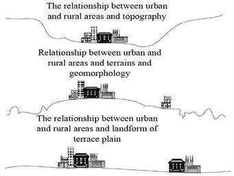
River channel type: the urban and rural areas are distributed on both sides or on one side of a wider River channel. Due to the limitation of topography, the urban and rural land extends along the river banks or valleys, forming a zonal layout. The main characteristic of the banded layout is that its plane structure develops in the same direction with traffic lines and traffic flows, and has a strong directionality (Peng et al., 2017). Land tends to develop along rivers. Residential, commercial services and industries are arranged on one or both sides of the main traffic lines. In the early stage of urban and rural development in Chuandao, because of the small area, small scale, population concentration, low degree of regional differentiation, and less restrictive effect of terrain on urban and rural areas, the urban and rural agglomeration and compactness are high, showing a crumby structure. With the growth of urban and rural population, the expansion of urban and rural scale, and the differentiation of urban and rural functions, the spatial structure also changes. Landform has a decisive impact on the expansion of urban and rural areas. Urban and rural expansion generally chooses better conditions for the development of the River channel, and urban and rural areas begin to develop in a zonal manner.
Plateau surface type: urban and rural location is the plateau surface located in the Loess Plateau gully area and residual plateau gully area. Generally, the large plateau surface (Dongzhi Plateau) is 400-500 meters higher than the valley, while the small plain (Shili Plateau) is 200-300 meters higher than the valley (Wan Mahari et al., 2018). The erosion around the plateau is active and serious, while the loess overlay on the plateau is deep, the land is flat and the soil quality is good, mainly homogeneous arable land. The cultivated land area is large, the farmland forest network is grid-like, and the patches of villages and towns are mosaic. In Qingyang, Dongzhi, and Xiaojin towns on Dong Zhi Plateau, Changwu County on Changwu Plateau, Majia Town, and Shili Township on Shili Plateau, Miaoqu Town and Mengba Town on Mengba Plateau, urban and rural morphology mostly develop into blocks in the plateau topography. Urban and rural development extends from inside to outside, mostly along traffic trunk lines. Traffic trunk lines often become the guide of settlement development and evolution.
The Loess terrace plain type: it has a flat terrain, fertile soil, abundant water sources, convenient irrigation and drainage, convenient transportation, better soil texture, and better agricultural production conditions. The reclamation rate and cropping index are high, and agriculture and animal husbandry are relatively developed. For Jingyang County, Luqiao Town of Sanyuan County, Liquan County, Fenghuo Town, Zhao Town, and so on, these common forms of urban and rural areas are centralized, compact land use, which is a compact and efficient layout form. Cluster form is a common form of terrace plain in urban and rural areas. The land-use layout is compact, the road system presents a network pattern, and the development axis of urban and rural areas is not obvious. After the enlargement of urban and rural scale in the initial stage of belt development, the road system gradually evolved into a more complex network pattern, making urban and rural land more compact and saving land use.
Spatial Characteristics of Urban-Rural System
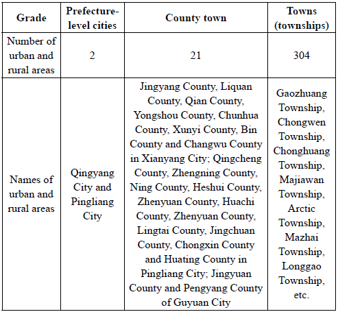
By the end of 2015, there were 327 urban and rural areas in Jinghe River Basin, including 2 prefecture-level cities, 21 county towns, and 304 townships. Urban density is 0.4/10,000 square kilometers, urban and rural density (district and county level) is 4.9/10,000 square kilometers, and township density is 70.3/10,000 square kilometers. The statistical results of urban and rural quantity in the Jinghe River Basin are shown in Table 1.
According to the topographic and geomorphological features, there are 170 townships in the Loess Plateau gully area, accounting for 55.9% of the total, while there are only 12 townships in the Loess Rocky Mountain area, accounting for 4.6% of the total. According to the location of River channel, Plateau and Terrace, there are 142 townships on the surface of Loess Plateau, accounting for 46.7% of the total; there are only 26 villages and towns in the Leung of the Loess Plateau, accounting for 8.6% of the total. The results of the analysis of the distribution and location of urban and rural areas according to the topography and geomorphology are shown in Table 2.
Table 2 Distribution and Location of Urban and Rural Areas in Terrain and Landform (Unit: Number)
| Position | Chuan Dao | Tableland | Liang Mao | Terrace | Total | |
|---|---|---|---|---|---|---|
| Hilly-gullied loess region | 55 | 0 | 24 | 0 | 79 | |
| Topographic features | Loess Plateau Gully Area | 28 | 142 | 0 | 0 | 170 |
| Loess Rocky Mountain Area | 12 | 0 | 2 | 0 | 14 | |
| Loess terrace plain area | 0 | 0 | 0 | 41 | 41 | |
| Total | 95 | 142 | 26 | 41 | 304 | |
Optimizing the Spatial Distribution Characteristics of Urban-Rural System
(1) According to the suitable index of human settlements environment and the spatial differentiation characteristics of the ecological space environment, the current situation of social and economic development and the need for the coordinated development of environment and economy in the future, the basic model of large dispersion and small aggregation is adopted. Great decentralization maintains the institutions and functions of ecosystems in the form of zero integration. Small agglomeration refers to the formation of larger and more agglomerated urban and rural areas on a large plateau and broad river roads. The main problem of the population on the Loess Plateau is that it is too dispersed (Hua et al., 2013). The rational reorganization of urban and rural spatial structure can be achieved by guiding the population in the gully area to flow orderly to the urban and rural areas of the plateau and River channel.
The urban-rural spatial system of the Jinghe River Basin is the main structure of five districts, nine River corridors, and four plates. Five areas refer to ecological protection areas, ecological control areas, ecological coordination areas, human settlements control areas, and human settlements construction areas. The corridor of the Jiujiang River system refers to the Jinghe River, Malian River, Puhe River, Heihe River, and its main tributaries, Ruhe River, Daxi River, Milan River, Malan River, and Rouyuan River. The fourth plate refers to the Dongzhiyuan Plate dominated by Qingyang City, the upper reaches of Jinghe River dominated by Pingliang City, the lower reaches of Binchang Xunjing River dominated by Binchang County (Changwu Plateau) Plate and the Weihe River stepped plainly dominated by Jingyang County and Liquan County.
The urban-rural system planning of Jinghe River Basin, in accordance with the principles of urban-rural coordination, perfection of functions, development of small cities and towns, and highlighting special features, promotes the functions of the core cities of Pingliang City and Qingyang City, optimizes the urban form, cultivates such regional sub-central cities as Bin County, Changwu County, Jingyang County, Qian County, Liquan County, Qingcheng County, Ning County, Zhenyuan County, Huan County and Jingchuan County, and improves the urban and rural functions of Yongshou County, Chunhua County, Xunyi County, Lingtai County, Chongxin County, Zhengning County, Heshui County, Huachi County, Jingyuan County and Pengyang County, so as to accelerate the key towns building, form a urban and rural system of Jinghe River basin with regional characteristics of the Loess Plateau, and construct a five-level urban and rural system of core cities, regional sub-central cities, general cities, key towns and general towns. The scale of urban and rural classes in the Jinghe River Basin is shown in Table 3.
Table 3 Scale of urban and rural levels in the Jinghe River Basin
| Scale Grade | Level 1 Urban and Rural Areas | Level 2 Urban and Rural Areas | Level 3 Urban and Rural Areas | Level 4 Urban and Rural Areas | Level 5 Urban and Rural Areas |
|---|---|---|---|---|---|
| Scale standard (person) | 60 ten thousand About | 10-25 ten thousand | 5-10 ten thousand | 3-5 ten thousand | 1-3 ten thousand |
| Names of urban and rural areas | Central District of Qingyang City and Central District of Pingliang City | Binxian County, Changwu County, Jingyang County, Qian County, Liquan County, Qingcheng County, Ningxian County, Zhenyuan County, Huating County, Jingchuan County | Yongshou County, Chunhua County, Xunyi County, Lingtai County, Chongxin County, Zhengning County, Heshui County, Huachi County, Jingyuan County, Pengyang County | Taicun Town and Malan Town in Xunyi County; Runzhen Town and Fangli Town in Chunhua County; Xinmin Town, Arctic Town and Shuikou Town, Binxian County; Xianggong Town and Tingkou Town, Changning Town, Yongshou County; Changning Town, Yongshou County; Chagan Town, Yanxia Town and Caodong Town in Liquan County; Fengyang Town, Qianxian County; Yunyang Town and Wangqiao Town in Jingyang County; Shizi Town and Chaona Town in Lingtai County; Ankou Town and Maxia Town in Huating County; Wangcun Town and Yaodian Town of Jingchuan County; Xinyao Town of Chongxin County; Kongtong Town, Baishui Town and Shilipu Town in Kongtong District; Jingheyuan Town and Liupanshan Town in Jingyuan County; Wang Wa Town and Baiyang Town in Pengyang County; Tunzi Town, Mengba Town and Pingquan Town, Zhenyuan County; Gonghe Town and Yulinzi Town in Zhengning County; Changqing Bridge Town, Hesheng Town and Zaosheng Town in Ningxian County; Old Town and Country in Heshui County; Xiaojin Town and Dong Zhi Town in Xifeng District; Yima Town, Sanlipu Town and Maling Town, Qingcheng County; Huachi County Yuancheng Town and Country; Quzi Town and Mubo Town of Huanxian County | Other towns |
(2) Carbon emissions in urban and rural areas can be reduced through industrial restructuring, healthy lifestyle and technological innovation, but these measures cannot change the traffic trip and its corresponding energy consumption and emissions caused by the layout of urban and rural spatial structure (Jiang et al., 2013). Once the urban and rural spatial structure determined by urban and rural planning is established, the structural adjustment of traffic trip will be very difficult. Because of the lock-in effect of spatial structure of urban and rural systems on carbon emissions, the total amount of energy consumed and CO2 and other greenhouse gases emitted by transportation increases rapidly and is very difficult to control. Therefore, the establishment of eco-friendly urban-rural system spatial structure with "low-carbon" is the key to achieve the goal of ecological urban-rural construction in loess landform.
1) Principles of optimizing regional urban-rural spatial structure Integrating the main body of urban and rural spatial planning according to loess landform characteristics, the control and guiding role of planning is strengthened; combining with the landform of Jinghe River Basin, a regional urban and rural spatial pattern with multi-center, network and public transport corridor-type is constructed, corridor-type development with track or regional public transport guidance is adopted, and the coordination of regional public transport network and spatial layout pattern are emphasized. Functional urban areas are organized through the new functional division of labor between urban and rural areas in the region (Ji & He, 2019). The adjustment of urban and rural spatial structure should be coordinated with the planning of employment and residence in order to achieve the "low-carbon" urban development goal, and the efficient public transport system should be used to effectively link urban and rural areas together to form a regional "functional balance"; the corridor-oriented spatial organization model guided by inter-city rail transit and regional public transport should replace the satellite-oriented and centripetal-oriented spatial organization model commonly used in current planning. The theoretical basis of spatial structure of urban and rural areas should shift from central geography theory to multipolar network nested theory model. The construction of large-scale public facilities should be combined with a public transport hub to control the use of cars. The regional development model with weak control mainly by road network caused by the growth control mode of green belt will eventually promote the use of cars. More encouraging is the green wedge-spaced urban spatial expansion of public transport, focusing on new development of a public transport hub, to achieve a controlled compact relief.
2) Strategies for optimizing regional urban-rural spatial structure According to the above theory, at the regional level, it is suggested that the urban-rural spatial structure of the loess landform type areas should follow the corridor-type development model guided by the important trunk roads such as railways and expressways, take the polarized development of urban and rural areas in key areas as the core, and combine the points and axes, form the urban-rural spatial network structure in series. In most other areas, the ecological environment is harnessed and restored to build a green base for urban and rural development (Hong et al., 2018).
Under the restriction and influence of topographic and geomorphological conditions and water resources conditions, urban and rural construction land is mostly distributed in Jinghe River. Jinghe River Basin is the first region to develop human settlements. Apart from the military defense function of urban and rural areas, open terrain and adequate water resources are also important ecological support conditions. The main development of urban and rural areas is directly affected by the valley landform. Urban and rural construction land develops along the terrain and its rivers under the stress of landform conditions, mostly on the terrace of surface runoff. Among them, rural and urban reclamation, landscape, buildings and so on are distributed on the first terrace of Jinghe River, while the second terrace is distributed on the low-density urban and rural construction, and the main urban and rural construction is distributed on the third terrace of Jinghe River. Regionally, the distribution of human settlements is uneven, and there are different distribution characteristics along with the difference of geomorphology. On the whole, the population gradually changes with the geomorphic combination characteristics, which are high in the South and low in the North, and high in the East and low in the West. It also gradually decreases with the divergence of the main trunk of the Jinghe River Basin system to the end.
Spatial Distribution Characteristics and Optimum Layout of Urban and Rural Areas in Karst Geomorphological Area
Spatial distribution of urban and rural settlements in Guangnan county
(1) Overall Characteristics of Spatial Distribution of Urban and Rural Settlements
Based on the vector distribution map of urban and rural settlements in 2015, ArcGIS software is used to select the comparative statistical analysis of landscape indices, such as the number of urban and rural settlements, the total area of settlements, the average area of settlements, the density of spots, the minimum area of spots and the maximum area of spots. The landscape indices of urban and rural settlements in Guangnan County in 2015 are shown in Table 4.
Table 4 Landscape Index of Urban and Rural Settlements in Guangnan County in 2015
| Scenery | Landscape Index |
|---|---|
| Number of plaques (number) | 14016 |
| Patch density (per /km2) | 0.98% |
| Total patch area (m2) | 76606672.8 |
| Minimum plaque area (m2) | 399.02 |
| Maximum plaque area (m2) | 266582.08 |
| Average patch area (m2) | 5465.66 |
The density of urban and rural settlements in Guangnan County is obtained by using Arc Info function in ArcGIS. Generally speaking, the spatial distribution of urban and rural settlements is scattered, but not random and regular. Under the influence of the unique geographical environment such as slope and elevation, the areas with moderate elevation and certain gradient are the main districts of urban and rural settlements in Guangnan County. The urban and rural settlements in the areas with elevation above 1500 m and slope above 25° are sparse; the scale of urban and rural settlements along rivers is relatively large due to the influence of river system; and affected by the degree of transportation convenience and other factors, the urban and rural settlements along the highway are more intensive.
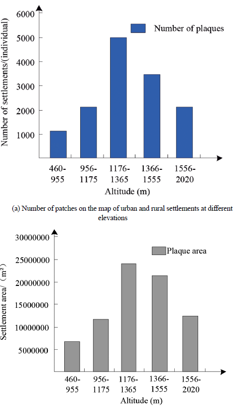
(2) Spatial distribution characteristics of urban and rural settlements at different elevations
From 460 to 2020 m above sea level in Guangnan County, the DEM module of ArcGIS software is used to divide the altitude into five elevation zones by the equal grading method. The attribute data of urban and rural settlements are superimposed with the attribute data of elevation by Overlay module, and the distribution area of urban and rural settlements in different elevation zones is obtained as shown in Table 5.
Table 5 Statistics of urban and rural settlements in different elevation zones in 2015
| Scenery | Landscape Index |
|---|---|
| Number of plaques (number) | 14016 |
| Patch density (per /km2) | 0.98% |
| Total patch area (m2) | 76606672.8 |
| Minimum plaque area (m2) | 399.02 |
| Maximum plaque area (m2) | 266582.08 |
| Average patch area (m2) | 5465.66 |
From Table 5, it can be seen that, with the rising altitude, urban and rural settlements gradually become sparse and the climate has obvious changes, the higher the altitude is, the worse the agricultural production conditions are; the main urban and rural settlements in Guangnan County live below 1500 m. Adequate electricity, convenient transportation and water use are the advantages of low-altitude areas, which are convenient for villagers to live in for a long time. With a relatively large population, urban and rural settlements show a strong elevation orientation. To sum up, the distribution of urban and rural settlements and elevation shows a normal distribution relationship, as shown in Figure 3.
(3) Spatial distribution characteristics of urban and rural settlements on different slopes
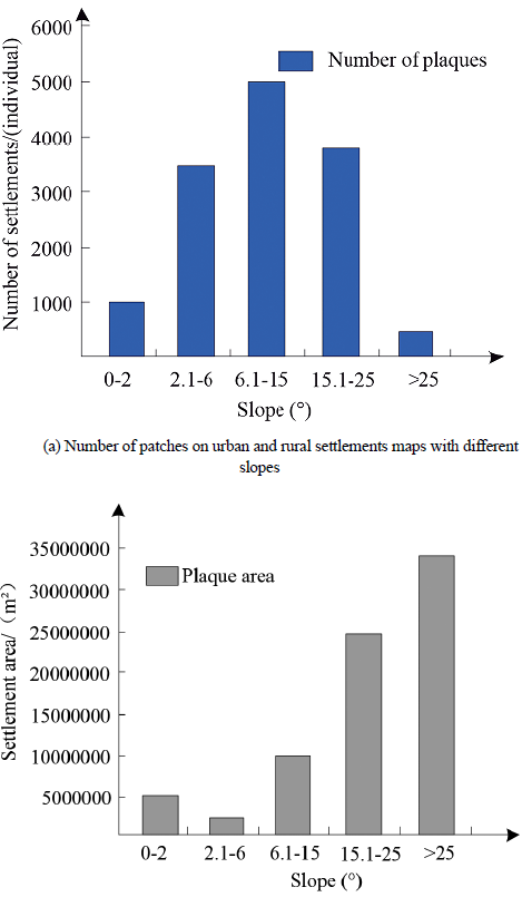
Using the DEM module of ArcGIS software, the gradient is divided into five gradient zones according to the critical gradient grading method. Overlay module is used to overlay the attribute data of urban and rural settlements and the related attribute data of gradient, and the distribution area of urban and rural settlements in different gradient zones is obtained, as shown in Table 6.
Table 6 Statistics of urban and rural settlements in different slope zones in 2015
| Slope (°) | 0-2 | 2.1-6 | 6.1-15 | 15.1-25 | >25 |
|---|---|---|---|---|---|
| Plaque (individual) | 111002 | 418703 | 605243 | 458222 | 81206 |
| Number ratio (%) | 6.62 | 24.89 | 36.03 | 27.25 | 4.76 |
| Pplaque area (m2) | 576393931.50 | 275426853.04 | 984562766.30 | 2477144677.65 | 3416321408.14 |
| Area ratio (%) | 7.35 | 3.45 | 12.63 | 32.04 | 44.09 |
From Table 6, it can be seen that the largest number of urban and rural settlement patches is between 2.1° and 25°, accounting for 89% of the total. In areas with slopes between 0° and 20°, the total proportion of urban and rural settlements is less than 10%, and the number of urban and rural settlements above 25° is less than 5%. However, the area of urban and rural settlements in areas with slopes above 15° accounted for 76% of the total area. This is because Guangnan County is a karst mountain area. Limestone in the karst area is easy to be eroded by water to form groundwater. Groundwater will be stored in the area with the lowest slope. Soil in the rocky desertification area in the Guangnan area is easy to be washed down by rainwater to the area with the lowest slope. Therefore, residents will use the area with the lowest slope as cultivated land and settlements will choose the place with a certain slope.
To sum up, we can get the relationship between the distribution of urban and rural settlements and the size of slope, as shown in Figure 4.
Optimizing the Spatial Distribution Characteristics of Urban and Rural Settlements
From the above, it can be seen that karst landform determines the landscape index, spatial distribution characteristics and spatial distribution characteristics of urban and rural settlements at different elevations and slopes in Guangnan County (Soto et al., 2017). Therefore, the planning of socialist urban and rural construction in karst geomorphic regions, the optimization of spatial structure of urban and rural settlements and the development of small and medium-sized urban and rural areas should be based on the full investigation of spatial structure and distribution of karst geomorphic settlements. On the other hand, karst environment is a very fragile ecological environment. The premise of every work is to harness, protect and improve the ecological environment, so we must optimize the settlement space structure based on the ecological concept, respect and follow the natural process.
(1) Respect the spatial self-organization model of existing urban and rural settlements
The present settlement is a long-term adaptation to the fragile karst ecological environment and the result of the continuous harmony and unification of the contradictions between human and land. Therefore, when optimizing the living space, we must respect the spatial self-organizing mode of the existing settlement, and consider the natural conditions, social and economic development and residential culture of the karst geomorphological type area (Martín-Díaz et al., 2018).
(2) Moderate settlement scale
Karst is a very fragile ecological environment with many mountains and few flat lands. Therefore, the environmental capacity of urban and rural settlements development is very limited, and the appropriate scale of settlements must be considered. Appropriate settlement scale in karst urban and rural areas should be based on population, land use of settlements, the relationship between them and regional carrying capacity of cultivated land resources, land use structure, water resources, rocky desertification and soil erosion, labor employment, population migration, social and economic development and other factors. Regardless of the population of settlements or the scale of residential land, there are huge spatial differences in karst-plateau-basin area, plateau-mountain area and plateau-canyon area. It is necessary to evaluate comprehensively from various aspects and complete the investigation and prediction of the current situation with different methods in order to formulate an appropriate and reasonable scale of urban and rural settlements and optimize the spatial structure of urban and rural settlements in karst landform type areas.
(3) Monitoring of settlement space development
In recent years, urban and rural settlements in karst areas have many new characteristics in spatial extension, such as the empty and waste of old settlements, the strip extension of new buildings along highways, etc. (Yan et al., 2018). In addition, the changes of settlement land use, regional land use type and structure, especially the changes of rocky desertification and soil erosion, have an important impact on the development of settlement space, and directly penetrate into residential culture. Therefore, it is necessary to use the DEM module of ArcGIS software to monitor real-time in order to investigate the problems in settlement development, predict the trend of settlement evolution, and make a good spatial planning of settlement development.
(4) Optimizing the residential space of settlements
On the basis of the existing settlement spatial pattern, we should optimize the spatial pattern and focus on the control and restoration of the ecological environment, especially the control of rocky desertification and soil erosion. On this basis, we should realize the rational utilization of land and the optimization of spatial structure, strive for more and more reasonable land for urban and rural settlement spatial development, and develop and protect the cultivated land, forest land and garden land on which we depend for survival. Emphasis should be placed on supporting facilities construction, environmental improvement and transportation facilities construction (Hong, 2017).
Discussion
The regional topography and physiognomy of loess landform types play a decisive role in the spatial distribution of urban and rural areas. This paper uses GIS and related statistical analysis software to analyze the overlap and correlation of the topography and physiognomy of Jinghe River Basin, urban and rural patches, and summarizes three basic urban and rural types, namely, River channel type, Plateau surface type and terrace type. At the same time, the spatial distribution characteristics of urban and rural systems are analyzed in detail. According to the suitable index of human settlements environment and the spatial differentiation characteristics of ecological space environment in Jinghe River Basin, the present situation of social and economic development and the need of coordinated development of environment and economy in the future, the main structure of urban and rural space system, corridor of five districts, nine rivers system and four plates is put forward under the background of the new round of urbanization in the Jinghe River Basin, in order to solve the contradiction between urban and rural development and ecological environment deterioration in Jinghe River Basin, provide guidance for the coordinated development of regional natural environmental protection and social economy, and promote the scientific and orderly development of urban and rural areas.
ArcGIS is used to extract the urban and rural settlement patches and generate the density map of urban and rural settlement in Guangnan County. The total area of the patches, the average area of the patches, the density of the patches and other landscape indices are obtained for comprehensive analysis. Elevation map and slope map are generated by DEM module, and then overlapped with urban and rural settlement patches by Overlay module. Through the above analysis, the following conclusions can be drawn: (1) Due to the high environmental vulnerability and sensitivity of karst mountainous areas and the constraints of human activities, rocky desertification in Guangnan County is serious, and the area of Rocky Mountains is wide and dispersed, which results in the extremely dispersed distribution of settlement patches. Because of the difference of natural conditions (elevation, elevation, slope) in Guangnan County, there are obvious spatial differences in the distribution of urban and rural settlements. (2) With the change of different elevation zones, the pattern of urban and rural settlements also changes. The pattern of urban and rural settlements at 1100-1500 m elevation is the most, which indicates that this elevation zone is most suitable for the location of urban and rural settlements. (3) From the view of urban and rural settlement patches in different slope zones, there are obvious differences and uniqueness between slope and plain. The number of settlement patches is normal distribution with slope, but the area of urban and rural settlement patches is proportional to slope.
Conclusions
Natural environment is the material basis for human survival and social and economic development in urban and rural areas. Different geographical units limit the spatial environment for urban and rural development. Distribution characteristics and trends of urban and rural space in different geomorphic regions are not only influenced by socio-economic development and national cultural customs, but also by the surrounding natural environment conditions, which have a far-reaching impact on them, and even affect the appearance, size, layout and trend patterns of urban and rural settlements. Therefore, in view of the spatial distribution characteristics of urban and rural areas of loess and karst landforms, this paper puts forward the optimal layout strategy, which provides the basis for choosing the reasonable model of urban and rural development and formulating the optimal countermeasures of urban and rural interactive development. There are some shortcomings in this study. Because of the different data sources, the results of spatial feature analysis may be different. With the continuous updating and improvement of data sources, this study will be more accurate. In addition, this paper only analyses the natural environmental factors, but fails to carry out relevant research based on the regional socio-economic data of different geomorphological types. Therefore, it fails to mine deeply into the characteristics, structure and laws of urban and rural settlements, which will become the direction of further research in the future.

