


 English (pdf)
 Article in xml format
 Article references
 Send this article by e-mail
 Cited by SciELO
  Cited by Google
  Similars in
SciELO
Similars in
SciELO  Similars in Google
 Permalink
Introduction
The middle Permian in Northwest Sichuan is an important field of natural gas exploration in the Sichuan Basin. In recent years, several wells have obtained high-production in Qixia Formation and Maokou Formation (Dahai et al., 2016; He, 2014; Shen et al., 2016; Yuanjiang, 2019), showing good exploration prospects. Several sets of source rocks, such as carbonate rocks, argillaceous rocks, and coal, were developed in the Paleozoic (Hui et al., 2012; Lu et al., 2017; Dong et al., 2011), they superimposed and crossed each other on the plane, resulting in oil and gas channeling and mixing in the formation, resulting in complex gas source relationship (Li et al., 2015; Zhang et al., 2019; Jie et al., 2016). At the same time, multi-stage tectonic movements (Chen et al., 2019) caused multi-stage hydrocarbon generation, migration and accumulation, and adjustment and transformation, which complicated the oil and gas system and led to an unclear understanding of the conditions and modes of hydrocarbon accumulation, and seriously hindered the further exploration progress. In recent years, with the discovery of the lower Paleozoic Cambrian Longwangmiao Formation and Sinian large gas fields in the middle Sichuan paleouplift area (Gu et al., 2016; Shen et al., 2016; Wei et al., 2008; Xingzhi et al., 2019), indicating that the deep Marine strata in Northwest Sichuan Basin may have a good prospect for the discovery of large-scale oil and gas reservoirs (Yang et al., 2019; Yu et al., 2018; Xiao et al., 2018). Therefore, an in-depth study of the basic geological conditions of the Middle Permian hydrocarbon accumulation in Northwest Sichuan and the establishment of a hydrocarbon accumulation model will be helpful to the re-understanding of Marine hydrocarbon distribution in this area.
Geological settings
Northwestern Sichuan is located in the western margins of the Yangtze Plate between the Sichuan Basin and the Songpan-Ganze Orogenic Belt (Fig. 1). This region extends northwards to the Chaotian District of Guangyuan City and southwards to the Mianyang City-Yanting County.
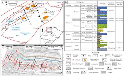
Figure 1 Location, tectonic setting, and stratigraphic column of the studied area, NW Sichuan Basin. (a) Geologic map showing the tectonic outline and wells and outcrop profile location in NW Sichuan Basin. (b) AA' linked line Seismic profile. (c) Stratigraphic column of Northwest Sichuan Basin (According to the Research Institute of Southwest Oil and Gas filed, 2015).
The Northwestern Sichuan has experienced the following tectonic evolution stages. (1) The Northwestern Sichuan Basin was a depression during the early Cambrian that eventually became the most important source rock horizon in the Paleozoic system due to the deposition of the Lower Cambrian marine fragmental rocks (Fig.1b). (2) At the end of the Silurian Period, the Silurian and Ordovician strata were strongly eroded due to the Caledonian orogeny. This region began to sink again after the Caledonian orogeny leading to the deposition of marine and carbonate-dominated Devonian and Carboniferous strata (Chen et al., 2019). (3) The Yunnan movement at the end of the Carboniferous period severely eroded the Carboniferous strata (Gu et al., 2016; Yingqiang et al., 2016). The northwestern Sichuan Basin was again sea covered at the beginning of the Permian period, which led to the deposition of the Permian and Middle-Lower Triassic marine strata. (4) The basin then contracted during the Late Triassic due to the Indo-China orogeny that led to the seawater retreat that thus marks the beginning of terrestrial sedimentation (He, 2014). (5) After the Jurassic period, a sharp uplift occurred in the Longmen Mountains of northwestern Sichuan due to the Yanshanian and Himalayan orogeneses (Meng et al., 2016). This resulted in severe stratigraphic erosion in these regions. This series of events ultimately gave rise to the current tectonic state of the region.
The study area developed three tectonic units: the thrust nappe belt, the hidden front belt, and the depression belt according to the characteristics of tectonic development in Northwest Sichuan. Driven by tectonic movement, thrust occurred in Longmen Mountains to form nappe tectonic belt (Gu et al., 2016; Renqi et al., 2016; Yingqiang et al., 2016) became the western boundary of the basin, and typical structures developed included Hanwan chang-Kuangshan anticline, etc. High-yielding gas reservoirs were found in the Qixia Formation and Maokou Formation, and the key exploration wells were K1, K2, K3, H1, H2, H12, and HS1. In the front edge of the thrust fault, the hidden front belt was formed, which is mainly distributed in the Shuangyushi-Zhongba structural belt, and exploration wells S1, ST1, and ST3 were drilled in the middle Permian with high-yielding gas reservoirs. The area east to Nanjiang-Cangxi-Yanting is the depression belt with typical structures such as Wujiaba-Jiulongshan structure, etc., and the exploration wells in the middle Permian are WJ1, L17, L16, GJ, B1, etc. (Fig 1c).
Samples and methods
Samples and data
In this study, a total of 128 samples were selected, including 62 hydrocarbon source rocks, 12 natural gas samples, and 54 reservoir samples, based on the comprehensive sampling of different structural belts and different strata. The source rock samples were mainly taken from Wells HS1, K1, K3, WJ1, S1, H2, GJ, L17, ST2, and ST3, as well as the field sections of Northwest Sichuan Tongkou, Changjiang ditch, Qiaoting, and Tongkou. Natural gas samples were taken from wells ST1, ST2, and ST3. Reservoir samples were taken from wells K1, K2, K3, ST3, L16, and WJ1, etc. At the same time, some oil and gas field reservoir physical property test and analysis data were also collected.
Besides, seismic data on middle Permian gas reservoirs have been collected from the Exploration and Development Research Institute of PetroChina Southwest Oil & Gasfield Company, including seismic interpretation section (AA ') and seismic interpretation section of wells K1, S1, H2, ST3, and G5. The single well analysis data, including formation pressure and formation water data of wells ST2, L17, B1, GJ, H1, and K3, and data of some wells with denudation thickness of regional strata and basin simulation in Northwest Sichuan were collected from the same institute.
Experimental methods
Solid bitumen reflectance
The solid bitumen reflectance was measured using an MPV-3 microphotometer, related accessories, and a QDI302 microscope. The standard used for these measurements was a yttrium aluminum garnet (whose Ro is 0.92% in standard conditions). The measurements were performed with a magnification of x500 (the magnification of the oil immersion objective was x50) and an input wavelength of λ=546 nm (green light) under the standard of SY/T 5124-2012.
Organic carbon
The organic carbon measurements in the hydrocarbon source rocks were performed by first grinding the samples, followed by the addition of hydrochloric acid to remove the inorganic carbon. The samples were then inserted into a CS230SH sulfur/carbon analyzer under the standard of GBT 19145-2003.
Gas chromatography-mass spectrometry
The chloroform bitumen 'A' content in the samples was obtained by performing chloroform extraction on the crushed samples. After the asphalt was precipitated with n-hexane, the filtrate was passed through a silica gel column. Solvents with different polarities were then used to sequentially separate the saturated hydrocarbons, aromatic hydrocarbons, and non-hydrocarbons. Gas chromatography-mass spectrometry (GC-MS) analyses were performed on the saturated hydrocarbons using a Thermo Scientific Trace GC Ultra-DSQ GC-MS. The GC-MS analyses were performed using an HP-5MS elastic quartz capillary (60mx0.25mmx0.25 mm) GC column. The temperature program began with an initial temperature of 100 °C (held for 5 min), then increased at a rate of 3 °C/min up to 320 °C where the temperature was then held for 20 min. The carrier gas was 99.999% helium, and the inlet temperature was 280 °C. The sample was injected at a constant flow rate of 1 mL/min and the transmission line temperature was 300 °C. Electron impact ionization (70 eV) with a filament current of 100 mA and an ion source temperature of 250 °C was used as the mass spectrometry ionization method. The GC-MS analysis on the source rocks was also performed using the Trace GC Ultra-DSQ GC-MS under the standard of GBT30431-2013.
Natural gas composition and carbon isotope analyses
The natural gas composition analyses were performed using an HP6890 gas chromatograph, with an SGE-60 GC column (50mx0.25mmx0.25 mm). The inlet temperature of 300 °C was used with nitrogen as the carrier gas. The flow rate was 1 mL/min with a split ratio of 50:1. The temperature of the column was increased from 30 °C to 260 °C at a rate of 3 °C/min.
The carbon isotope measurements for the natural gas samples were performed using a Finnigan MAT-252 mass spectrometer under the standard of GBT 13610-2014. The carbon isotope values were then compared with the GBW 04405 reference to obtain the corresponding Pee Dee Belemnite (PDB) values. The standard deviation of these values was±0.3%o.
Thermal history model
Burial-thermal history analysis was prepared using PetroMod 1D software. The stratigraphic sequences, denudation thickness, and tectonic events were derived from geological reports of well K1, ST3, and L16. The source rock assignment and their respective properties, total organic carbon (TOC) and hydrogen indices (HI) implemented in order to simulate the thermal maturity of source rock.
Results
Source rock conditions
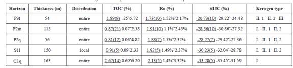
Field profile and drilling data in Northwest Sichuan have confirmed that multiple sets of source rocks developed in the Paleozoic era (Gu et al., 2016; Wu et al., 2012; Dong et al., 2011; Li, 2018). Based on the test of 62 samples of multiple sets of source rocks (Tab. 1), Qiongzhusi formation of the lower Cambrian has the highest abundance of organic carbon, and Toc distributed between 0.6 and 6.2%, with an average value of 2.67%. The second source rock is Longmaxi formation and Longtan formation, with mean values of 0.91% and 1.89% respectively. The average abundance of organic carbon in Maokou Formation and Qixia Formation is 0.87% and 0.81%, both of which have the basic conditions to form effective source rocks (Tab. 1).
Table 1 Geological and bulk geochemical data for source rock samples in Northwest Sichuan Basin
Note: 
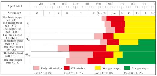
This study built three thermal evolution models of well K1, well ST3, and well L16 in different structural belts, as shown in Fig 2. It shows that the major Paleozoic source rocks in this area entered the oil generation threshold in the Late Caledonian, entered the condensate gas-moisture stage in the Late Triassic, and the dry gas stage in the early Cretaceous. At present, they are generally in the high-to-over mature stage, mainly producing dry gas. From Figure 3, the lower Cambrian heat evolution rate is low and was in the mature and over mature stage for a long time (Fig 3). Relatively speaking, the lower Silurian and middle Permian source rock with a higher thermal evolution rate showed that the foreland orogeny movement in western Sichuan promoted the source rock to enter the mature and high mature stage. Laterally, the source rocks in the thrust nappe belt, hidden front concealed belt, and depression belt enter the mature stage later, shows that the foreland movement has a delayed effect on the thermal evolution of source rocks in different structural belts. The source rocks of Lower Cambrian were in the stage of oil generation for a long time in the thrust nappe belt, which offered a good material base for the reservoir formation in this area. The thermal evolution history of Lower Silurian and Permian source rocks was close to Permian source rocks. Due to the large buried depth of the hidden front belt, the Lower Silurian source rock entered the dry gas stage from the Late Cretaceous.
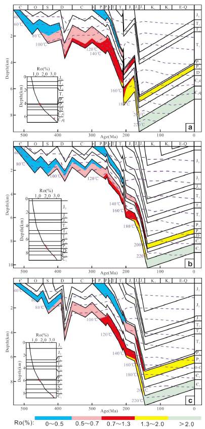
Figure 2 Thermal evolution of Lower Cambrian and Permian in Northwest Sichuan Basin. (a: K1 well. b: ST3 well. c: L16 well).
Due to the influence of the Caledonian paleouplift, the Silurian Longmaxi Formation, except for the large thickness of the Chaotian and Nanjiang Qiaoting sections, was pointed out southward in the Guangyuan-Cangxi area and had relatively limited influence on the oil and gas reservoirs. Therefore, it can be seen that the Lower Cambrian and Permian source rocks are the main sources of oil and gas accumulation in this area.
Reservoir conditions
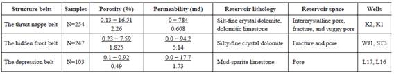
Based on the physical test of 54 reservoir samples and a large number of collected reservoir data, the basic characteristics of the Middle Permian reservoirs in the study area can be seen, as shown in Table 2. It shows that the lithology of the middle Permian reservoirs in Northwest Sichuan is mainly crystalline dolostone, followed by dolomitic limestone and sparite limestone. The porosity of the thrust nappe belt is between 0.13-16.51% with an average of 2.26, and the permeability is between 0.0-784 md with an average of0.608 md. The porosity of the hidden front belt was 0.23-7.59 % with an average of 1.825 %, and the permeability was 0-94.2md with an average of 5.14md. The porosity of the depression belt ranged from 0.1 to 0.92%, with an average porosity of 0.49%, and the permeability ranged from 0.0 to 17.7md, with an average of 1.73md. In comparison to the sedimentary rocks, the middle Permian reservoir exhibits low porosity and low permeability. In contrast, different structural belts that the thrust nappe belt and the hidden front belt have relatively high porosity and relatively developed fractures, which improve the permeability of the reservoir. On the other hand, the depression belt has poor porosity and permeability affected by the depth of burial.
Caprock and preservation conditions
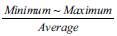
Two sets of important caprock developed in Permian and overlying strata of Northwest Sichuan. One is the regional mudstone of the Longtan Formation of Upper Permian, the thickness can reach more than 100 m. The mudstone of Longtan formation is both a good caprock of the underlying reservoir and the main source rock of the overlying reservoir, which constitutes a good regional caprock of the middle Permian reservoir. The other is the gypsum rocks developed in the Middle Triassic, with a cumulative thickness of between 50 m and 450 m. They are the indirect caprock of Permian oil and gas reservoirs (Chen Cong, 2019). In this paper, the characteristics of Paleozoic formation water and formation pressure coefficients were statistically analyzed, as shown in Table 3. It is shown that the wells H1 and K3 in thrust nappe belt from deep to shallow, the water type transition from calcium chloride type to sodium sulfate type, and formation pressure coefficient from 0.96 to 0.87, indicating that the strata were destroyed and the preservation conditions of Qixia Formation and Maokou Formation are poor. The water type of ST2 in the hidden front belt is calcium chloride type, and the formation pressure coefficient is 1.36, which is in the state of overpressure state and conducive to oil and gas preservation.
The formation pressure coefficient of wells L17 and GJ well in the depression belt is higher and the preservation condition is better. However, the water type of Maokou formation in well B1 is sodium bicarbonate type, and the formation pressure coefficient is 1.01, which is relatively low, indicating received the influence of Micangshan Fault-fold belt. Overall, the multi-stage tectonic movement has a great influence on the preservation conditions of the thrust nappe belt.
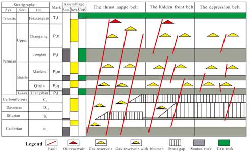
Trap development and distribution
This paper compiled the reservoir profiles of the key exploration wells in the research area, as shown in Figure 4. It indicates that the trap types of different belts are different due to the influence of the multi-stage tectonic movement. The thrust nappe belt mainly developed thrust blocks and thrust anticlinal traps (Fig 4a, 4d), while the hidden front belt formed a large number of fault-block traps under Caledonian - Hercynian tensile action, and some of the fault-block traps degenerated into compressed anticlinal traps under the compression action of Indo-China period (Fig 4b,4e). Due to weak tectonic activity, anticline and structure-lithologic traps were developed in the depression belt (Fig 4c). Overall, the traps in Northwest Sichuan are mostly structural traps, with the most developed fault traps, but the traps are small in scale.
Discussion Oil and gas source
Due to the few exploration wells and little data in Northwest Sichuan, the oil and gas source of middle Permian has not been clearly understood. At present, there is still a great dispute over the gas source of the middle Permian. Some scholars believed that the oil and gas mainly came from the Cambrian source rocks of the Lower Paleozoic through paleo-reservoir studies (Wu et al., 2012; Dong et al., 2011; Li, 2018). Other scholars proposed that oil and gas came from middle Permian source rock (Lu et al., 2017; Liu Chun, 2008) the ground of some geochemistry test. Besides, some scholars also supposed that some gas possibly came from the coal-measure source rocks of overlying Longtan Formation according to the carbon isotope of gas composition (Shen Ping, 2015). According to the chromatographic analysis of the source rock and the bitumen in the reservoir (Fig. 5), the peak types of n-alkanes in the source rocks of Qixia and Maokou formation in the middle Permian were all single-peak types, with the main peak carbon close to each other. The ratio of primers to phytane was less than 0.7, which showed a good similarity.
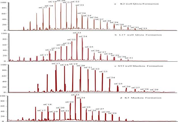
Figure 5 The n-alkanes chromatogram of asphalt and source rocks in middle Permian reservoirs in Northwest Sichuan. (a and c from the reservoir. b and d from the source rock.)
The ethane carbon isotopic data of Qixia formation, Maokou formation reservoir, and Paleogenic source rock kerogen are compared as shown in Figure 6. As you can see that the ethane carbon isotopes of Maokou formation in Hewanchang structure are relatively light, indicating that the gas reservoir in the thrust nappe belt was not only charged from the Permian source rocks but also underlying Cambrian source rocks (Huang Dong, 2011). In contrast, the carbon isotope of ethane of Qixia Formation and Maokou Formation in the Shuangyushi area is heavy, and the isotope of methane and ethane is reversed and revealed the character of the gas mixture. It is assumed that in addition to the natural gas generated from the source rocks of the Middle Permian and the Lower Cambrian, the coaliferous gas of the Upper Longtan Formation is mixed in the hidden front belt. The distribution of ethane isotopes in Maokou formation in Jiulongshan ranges from -35 %o to -26 %o, and methane and ethane isotopes are reversed, which shows typically mixed genesis. It is inferred that the Permian oil and gas in the depression belt come from their source rocks and overlying Longtan formation. In summary, these results show that the middle Permian oil and gas are mainly charged by the lower Cambrian system and the authigenic source rocks.
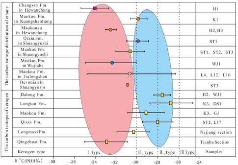
Figure 6 Carbon Isotope correlation of Kerogen and ethane of several source rocks in the Northwest Sichuan Basin. (Some data cited from Huang Dong, 2011)
Migration conditions
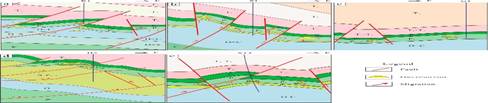
Due to a large number of faults, fractures, and unconformities under the influence of multi-stage tectonics in Northwest Sichuan (Dahai et al., 2016; Yang et al., 2019), a variety of oil and gas migration system has been formed, resulting in extensive longitudinal distribution of oil and gas in Paleozoic (Yuanjiang et al., 2019). Therefore, the understanding of the migration system was still relatively vague (Tian et al., 2012; Xiao et al., 2018). Based on the typical hydrocarbon accumulation profiles and the variation characteristics of natural gas carbon isotope in gas reservoirs, this study established the schematic map of middle Permian hydrocarbon accumulation to provide a new reasonable explanation for the secondary migration of oil and gas in this area, as shown in Figure 7. It can be seen that there are obvious differences of different structural belts in northwest Sichuan, in which a large number of imbricate thrust faults developed in the thrust nappe belt connected the Lower Paleozoic source rocks and form the migration channel of the Hewanchang anticline, resulting in light carbon isotopes of ethane in the gas reservoirs in this area. Interlayer faults and carrier beds in Shuangyushi and Wujiaba area are the main channels for oil and gas migration, resulting in ethane carbon isotopes of Permian gas reservoirs in the hidden front belt close to their source rocks, while the light part of ethane carbon isotope shows the characteristics of multi-source charging. The migration channel of the depression belt is mainly interlayer faults and fracture formed under the state of late Caledonian tension. The oil and gas are dominated by a close vertical migration system, and the ethane isotopes of the gas reservoir are close to the Permian source rocks.
Hydrocarbon accumulation model
The oil and gas accumulation in the middle Permian in Northwest Sichuan is characterized by "multiple sources and multiple periods", and the process of accumulation is relatively complicated (Chen et al., 2019; Gu et al., 2016; He, 2014; Yu, et al., 2018). Based on the characteristics of reservoir conditions, this study established the oil and gas accumulation model of middle Permian in this area to guide the study of oil and gas accumulation in different structural belts (Fig. 8).
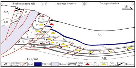
The Lower Cambrian source rocks are developed at the bottom of the thrust nappe belt in the study area, and the reservoirs of Maokou Formation and Qixia Formation are well developed in fractures and pores, and the reservoir physical properties are high. The caprock is the source rock and tight limestone at the bottom of the Middle and Upper Permian.
At present, a large number of bitumen and paleo-reservoirs are found in Cambrian and Devonian in Nianziba and Tianjingshan areas, indicating that the liquid hydrocarbons produced by the Lower Cambrian source rocks in the late Caledonian and Hercynian periods migrate upward to the Devonian reservoir along the faults connected source rock (Xiao et al., 2018). Some of the crude oil buried in the early stage was cracked into natural gas and migrated upward to the Permian, and then the gas reservoirs were formed in the Kuangshanliang and Hewanchang areas. Some reservoirs were transformed and destroyed by the Indo-China movement in the later stage and exposed to the surface. Therefore, the Paleozoic oil and gas reservoirs in this area have a reservoir formation model of " far-source charging, the assemblage of the lower source and upper reservoir", and the preservation condition is the key controlling factor.
Two sets of source rocks in the Lower Palaeozoic and Lower Permian are developed in the hidden front belt, and fracture-pore reservoirs are developed in the middle Permian (Benjian, 2019). The caprock is the source rock and tight limestone at the bottom of the Permian. Due to the multi-source hydrocarbon charging, the ethane carbon isotope in the gas reservoir of the Shuangyushi structure is light. Because the hidden front belt is on the thrown side of the thrust fault, the traps were preserved well. Therefore, the middle Permian gas reservoir in this area develops the mode of mixed source charging, the lower source and upper reservoir, and the fault connected source rock is the main controlling factor of the oil and gas reservoir.
The depression belt is located on the side of the rift belt in western Sichuan. It is far from the lower Cambrian source rocks, and the Permian source rocks are well developed with a high abundance of organic matter. The source rock and tight limestone at the bottom of the middle and upper Permian formed the caprock. And the tectonic and lithologic traps are developed. According to the analysis of the existing gas reservoirs in this area, the ethane carbon isotopes of middle and upper Permian gas reservoirs are similar to Permian kerogen, which indicates that the natural gas is mainly migrated upward to the nearby reservoirs along the interlayer faults. Therefore, the belt developed the characteristics of self-generation, self-reservoir, and self-caprock combination. Due to the large buried depth and good preservation conditions of the middle Permian in this area, formed the model of near-source charging, and interlayer fracture is the key factors for hydrocarbon accumulation.
Based on the above geological conditions and reservoir formation model, it is supposed that the middle Permian in Northwest Sichuan has better reservoir formation conditions, in which the hidden front belt is relatively weak in tectonic deformation, the developed anticlinal traps are well preserved, and the fault connected source rock is well developed. Since the remarkable discovery of well ST1 and ST3 in the Shuangyushi structure after 2014 (Bai Xiaoliang, 2019)), proved that the hidden front belt in the western Sichuan Basin may be a favorable area for oil and gas breakthrough in the deep marine field.
Conclusion
(1) The hydrocarbon source correlation supposes that oil and gas in Middle Permian mainly come from the bottom of the lower Cambrian and the Permian. The foreland orogeny movement on the longitudinal promoted the Paleozoic source rocks in the high-to-over mature stage, and on the transverse have delayed effect, causing hydrocarbon source rock of the thrust nappe belt, the hidden front belt, and the depression belt entered the mature stage of later and later.
(2) The structural traps are developed in the Northwest Sichuan Basin, among which the thrust nappe belt mainly develops thrust fault block traps, while the hidden front belt is dominated by compressed fault anticline trap, and the depression belt develops tectonic-lithologic traps, which have the characteristics of small in scale.
(3) The different structural belts in Northwest Sichuan have different oil-gas accumulation models, among which the nappe belt was affected by thrust fault and develops the assemblage of lower source rock and upper reservoir, and the preservation condition is the key. Under the influence of deep faults in the hidden front belt, the oil and gas come from the lower and self- source rocks. However, the depression belt is mainly controlled by the interlayer fracture and develops a model of self-generation and self-reservoir and near-source charging.
(4) Based on the accumulation conditions comprehensive analysis, the hidden front belt is close to the Cambrian source rock, with good source charging, well-developed fault connected source rock and good trap preservation conditions, and is a favorable oil and gas accumulation area in the Northwest Sichuan Basin.
Highlights:
(1) The middle Permian oil and gas in the northwest Sichuan Basin mainly come from the lower Cambrian and middle Permian source rocks, which are in the stage of the high-to-over mature stage.
(2) The middle Permian in northwest Sichuan developed an assemblage of lower source rock and upper reservoir, and faults had a great influence on hydrocarbon migration and accumulation.
(3) The hidden front belt is close to the lower Cambrian source rocks, with well-developed fault connected source rock and good trap preservation conditions. It is a favorable oil and gas accumulation area for the middle Permian.

