


 English (pdf)
 Article in xml format
 Article references
 Send this article by e-mail
 Cited by SciELO
  Cited by Google
  Similars in
SciELO
Similars in
SciELO  Similars in Google
 Permalink
Introduction
With the rapid economic development of all countries in the world, land resources have been unable to meet the needs of national development, so the ocean with rich natural resources will become the focus of follow-up development of all countries in the world (Lamchin et al., 2016; Zhang et al., 2015). It is necessary to map the islands in the ocean to realize the search and development of marine resources (Cao et al., 2016; Gorji et al., 2017; Nieuwhof et al., 2015). Currently, the information acquisition method for islands and reefs in many countries is mainly naval manual measurement. However, this method is inefficient and accompanied by substantial operational risks, which can no longer meet current marine development needs (Cummer & Inan, 2016; Liu & Zhou, 2017). Given this, this study proposes to use Aeronaves No Tripuladas (UAV) instead of artificial, using UAV remote sensing technology to detect islands in the sea area, hoping to provide a particular reference for the current sea area detection and supervision work.
UAV and GPS-assisted UAV remote sensing image acquisition and processing
Analysis of aerial triangulation
The aerial triangulation method is one of the most commonly used methods of UAV remote sensing measurement. This study obtains aerial image data through this method and carries out post-processing (Ren et al., 2019; Weixing et al., 2015). Analytic aerial triangulation, also known as analytic aerial triangulation encryption, its calculation essence is to obtain the control point position through actual measurement within several air belts or in the LAN composed of several air belts and carry out adjustment calculation for all image pair encryption points and external orientation elements of all images (Amin et al., 2020; Abboud & Nofal, 2020; Hoque et al., 2017). At present, three methods are mainly used in analytic aerial triangulation, which are an independent model method, flight belt method, and beam method (Alfy, 2016; Bi, 2020; Xu, 2020).
Figure 1 is the schematic diagram of aerial triangulation with the beam method. In this method, the images captured by a UAV remote sensing camera constitute a light beam, which is regarded as the basic adjustment calculation unit. The collinear equation of central projection is taken as the equation of adjustment calculation. After the beam's rotation and translation, the light of the same name between the models can achieve the best intersection, and the whole region can be transformed into the ground coordinate system. Then, the image's exterior orientation elements and the ground coordinates of all the measured objects can be obtained through adjustment calculation.
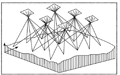
Among the three analytical aerial triangulation methods mentioned above, the beam method has the highest accuracy and the most rigorous theory, so the beam method has become the most mainstream analytical aerial triangulation method.
GPS aided aerial triangulation
In this study, the UAV is in a low altitude flight state, its flight altitude is low, the fuselage is light, and the airflow over the ocean is large, and the airflow changes very fast. Therefore, more heading and side overlap are needed in aerial measurement. At the same time, the single image area of the digital camera used by UAV is small, and the field measurement workload will be doubled by using UAV for aerial photography. In this case, reducing the number of ground image control points has become an urgent problem in UAV remote sensing application. In order to reduce the difficulty of UAV low altitude measurement, GPS-aided aerial triangulation is introduced in this study.
GPS-assisted aerial triangulation refers to the installation of GPS receiver on UAV, and continuous observation of GPS signal through Airborne GPS receiver and reference point receiver on the ground. Through the GPS carrier-phase differential positioning technology for data processing, the three-dimensional space coordinates of UAV at the time of shooting are obtained. The three-dimensional coordinate is taken as an additional observation value and introduced in the adjustment of the surveying area. The principle of converting the original ground control into air control is shown in Figure 2.
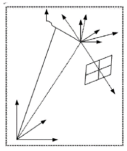
Figure 2 is the schematic diagram of GPS-aided aerial photogrammetry. When using this method, it is necessary to transform the aerial photography system and measure the eccentricity vector. The GPS receiver antenna is installed on the aerial plane, and the eccentricity vector from the photographing center S to the GPS receiver antenna phase center A is calculated. Secondly, the GPS receiver installed on the UAV is used to obtain the fieldwork signal of aerial photography. According to the size of the area to be measured and the mapping scale, the ground reference stations are reasonably arranged by using differential GPS positioning technology. Next, the coordinates of the Airborne GPS station are calculated by GPS observation data, and the coordinates are obtained by processing satellite ephemeris and GPS observation data. Finally, the photogrammetry and GPS station coordinates are adjusted jointly. Specifically, the spatial coordinates of the GPS antenna phase center are used as photogrammetric data for regional network joint adjustment, and then the spatial coordinates and accuracy of the target object are calculated.
At present, the increasingly mature UAV remote sensing technology provides strong support for the sea area supervision, which can realize the rapid monitoring task of the sea area. However, the increasingly complex situation of Marine Supervision puts forward higher requirements for the processing efficiency of UAV remote sensing photography. In this study, a variety of methods to improve the efficiency of the computer are combined to realize the rapid geometric processing of aerial photos.
The image fast geometric processing process is divided into five steps. First, we need to match the image and get the corresponding connection point. Under the condition of consistent images, the matching strength and speed of the algorithm are improved. Secondly, combined with POS data, the rapid adjustment of the regional network is carried out, and the sparse matrix is introduced in the calculation process. After matching the connection point, the amount of adjustment calculation should be reduced as much as possible to improve the calculation efficiency. In the third step, the connection points are interpolated to obtain the DEM in the survey area quickly, and the image ortho screening is carried out. Next, on the basis of the face Voronoi diagram image mosaic method, orthoimage mosaic is carried out to achieve less data redundancy and fast automatic mosaic. Finally, automatic extraction of sea area elements from the image map of the monitoring area is carried out to obtain the location data of elements in the corresponding sea area.
Experimental research and analysis
In order to verify the effectiveness of the UAV low altitude remote sensing system, experiments were carried out to detect the coastline of islands in the sea area. It is very difficult to detect the coastline of islands by manual on-site measurement, and there are areas that are difficult to reach manually, so the fieldwork is very heavy. This study will detect the coastline of islands by UAV remote sensing technology. The survey site was determined as an island bay in China. The vegetation coverage of the island bay is low, and the coastal topography is mainly hill with an altitude difference of less than 60m, which is suitable for UAV Low Altitude Aerial Photography.
In order to accurately grasp the location of the coastline, this study uses a three-dimensional laser to scan the coastal area of the island bay, and obtains centimeter-level fine DEM. After the refined DEM is obtained, GPS RTK is used to measure a section of coastline in the island bay area, and the measured coastline is obtained. The coastline extracted on the basis of aerial photography and radar is compared with the field measured coastline, and the results are shown in Figure 3.
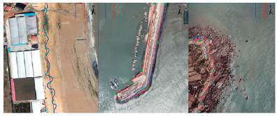
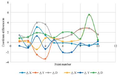
Figure 3 shows the comparison chart of Island Bay coastline results. (a), (b), (c) respectively show the comparison of general sandy shoreline, artificial shoreline, and bedrock shoreline. In Figure 3(a), 15 feature points are selected for comparison; due to the difficulty of manual measurement, only 10 feature points are selected in Figures 3(b) and 3(c). By comparing the coordinates of feature points obtained by different measurement methods, the measurement accuracy can be obtained.
Figure 4 shows the comparison results of the characteristic points of the sandy shoreline. As can be seen from Figure 4, the sandy shoreline extracted from UAV remote sensing images is quite different from that based on radar point cloud data. Compared with the measured results, it is found that the sandy shoreline extracted from the UAV remote sensing image is closer to the measured result, and the mean square deviation of both is less than 2 meters.
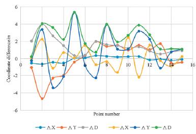
Figure 5 shows the comparison results of artificial shoreline and bedrock shoreline feature points. As can be seen from Figure 5, the difference between the two methods based on UAV remote sensing image and radar point cloud data is small, whether it is the coordinates of artificial shoreline feature points or bedrock shoreline feature points. Through further calculation, it can be seen that the mean square deviation of the feature point coordinates is within 2.5 m in both cases. In conclusion, the UAV-based low altitude remote sensing technology proposed in this study can interpret the information with high accuracy through aerial photography. This method can be combined with lidar technology in practical work, and then modify and offset the information extracted from remote sensing images to a certain extent. UAV remote sensing system is expected to become an important tool for sea area monitoring.
Conclusion
Because the ocean contains rich natural resources, and it represents the National Marine sovereignty, how to supervise the sea area has become the focus of attention of all countries. In this context, the study proposed to combine the sea area supervision and UAV remote sensing technology, and verified the method by an example. The research results show that the sea area information obtained by the UAV low altitude remote sensing system proposed in this study is closer to the measured information than lidar, and this method is expected to become an effective method to supervise the sea area. It is hoped that this study can contribute to the efficient development of marine regulatory work. In addition, there are still some problems in this study. When the UAV is used to carry out aerial surveys in an area far away from the coast, the image obtained by the UAV is likely to fall into the water, which will hinder the aerial triangulation to some extent, which will be improved in the future research.

