


 Inglês (pdf)
 Artigo em XML
 Referências do artigo
 Enviar este artigo por email
 Citado por SciELO
  Citado por Google
  Similares em
SciELO
Similares em
SciELO  Similares em Google
 Permalink
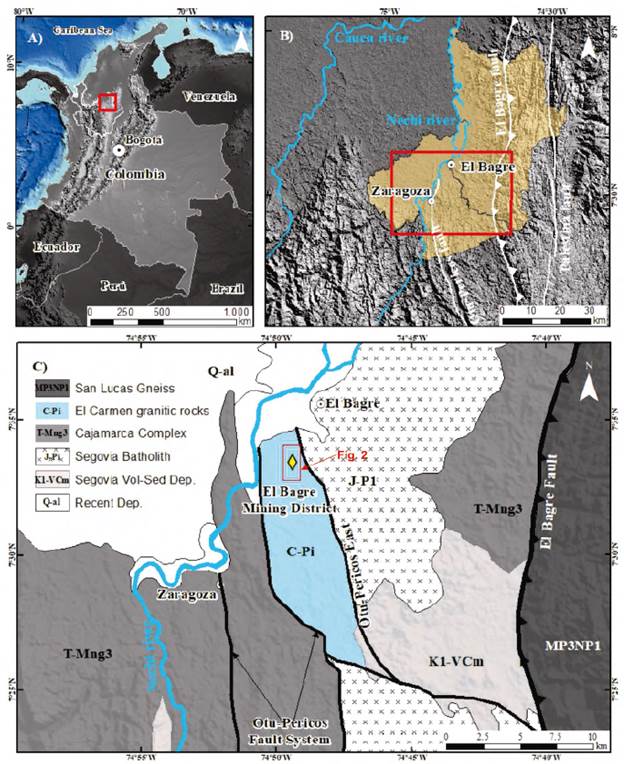
Figure 1 A). Simplified map showing the location of Colombia and Antioquia department. B). Regional map of the NE region of the Antioquia department., showing the region of Bajo Cauca (in orange) and the main major faults. C). Simplified geological map of the El Bagre mining district based on Gómez-Tapias et al., (2015).
Introduction
Orogenic lode gold type deposits are an important resource for gold (Groves et al., 1998; Moritz, 2000; Groves et al., 2003; Goldfarb et al., 2005; Goldfarb and Groves, 2015; Groves and Santosh, 2016). In the northeastern zone of Antioquia department of Colombia, several shear zone hosted lode gold type deposits are present. This region has long been recognized as an important historic gold district in Colombia (Shaw, 2000; Sillitoe, 2008; Londoño et al. , 2009; Leal-Mejía, 2011). Gold is frequently found in microscopic grains associated to sulphides. But at vein scale, discrete volume of rock with specific directions may contain high gold concentrations and are named "ore-shoots" (Wang et al, 2019). Ore-shoot occurrences are frequently related to specific structures such as faults, shear zones and folds (Hulin, 1929; Sibson, 2004) which can be organized in six groups (Wang et al., 2019): (1) intersection of a fault or shear zone with a particular lithological unit; (2) the intersection of two syn-metallogenic faults; (3) dilation jogs, divergent bends in faults or zones of en-echelon fault segmentation; (4) fold hinge zones; (5) flexures of lode or reef surface, with axes oblique to the movement direction (commonly at a high angle), and (6) zones that plunge subparallel to the striation (Wang et al., 2019).
Lode-gold type deposits at the El Bagre, are structurally controlled and ore-shoot shapes, orientation and distribution of high grades remains unresolved. Based on this scenario, a geostatistical analysis of gold grade data of the main deposits was used to investigate orientation, shape and regularity of high grades. Finally, the structural features of the deposits were integrated to elaborate a model for the ore shoots.
Geological setting
Regional Geology
In the northeastern zone of Antioquia department of Colombia, several shear zones hosted lode gold type deposits are reported. This region is situated in the Tahamí Terrane (Restrepo and Toussaint, 1988; Cediel et al., 2003; Restrepo and Toussaint, 2020 and Moreno-Sanchez et al., 2020) and is defined by low to high grade metamorphosed metasedimentary and pre to post-tectonic granitoid intrusions that formed during a Triassic metamorphism event (Restrepo and Toussaint, 2020). An important strike-slip NS to NNW fault system named Otu-Pericos is the main structure recognized in the region. This fault system separates Triassic metamorphic rocks associated to Cajamarca Complex from Carboniferous intrusive rocks from El Carmen stock (Gómez-Tapias et al., 2015). The kinematics of this regional fault are not fully understood in detail; however, right-lateral as well as left-lateral faulting and thrusting seem to have occurred (Horner, 2018). To the East, along the El Bagre reverse fault system, San Lucas Precambrian metamorphic rocks are in faulted contact with the Jurassic granitic rocks of the Segovia batholith. This fault system forms branches of N to NNE trending Palestina fault system, which has been recognized as a regional fault with right and left-lateral movement (Horner, 2018). All veins at the El Bagre mining district are hosted in shear zones within El Carmen intrusive rocks. These shear zones have brittle-ductile deformation which produced wall rock mylonitization, boudinage, vein off-sets and reactivation of wall rock-vein contact (Figure 1).
The El Bagre gold district
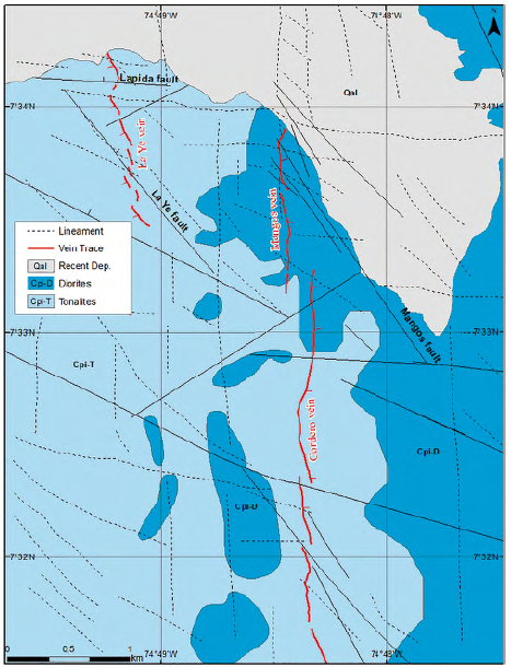
The main lodes of La Ye, Mangos and Cordero are hosted within carboniferous intrusive rocks of El Carmen stock. The timing of gold mineralization at El Bagre is likely to be between 284 and 276 Ma according to K-Ar and Ar-Ar sericite dating (Leal-Mejia, 2011 and Naranjo-Sierra, 2019). The gold mineralization at the El Bagre mining district are the only known occurrences of Permo-Triassic deposits in Colombia (Leal-Mejia, 2011; Naranjo-Sierra, 2019). Orebodies mainly strike NNW-NNE (340°-20°) and dip 30-45° to the east for Mangos and Cordero orebodies and at La Ye dip stepper with a mean dip angle of 65° to the west. These orebodies are crosscut by ENE-WNW and NNW-SSE faults (Figure 2).
The veins consist of milky white quartz containing native gold and up to 20% vol. sulfides, dominated by pyrite with local galena and chalcopyrite (Figure 3). Distributions of sulphides and native gold within veins are patchy (Figure 3B-D) (Naranjo-Sierra and Alvarán-Echeverri, 2020). Gold mineralization only occurs in massive quartz veins associated with pyrite, chalcopyrite, galena and tellurides (Calaverite (AuTe2), Sylvanite (AuAgTe2) and Altaite (PbTe) (Figure 3F, G and H). Close to the quartz lodes, the El Carmen stock is altered by hydrothermal activity, displaying a restricted chloride halo. Sericite and carbonates (Figure 3E), occurring as fine-grained crystals filling fractures, are the most common alteration minerals within quartz veins (Naranjo-Sierra, 2019).
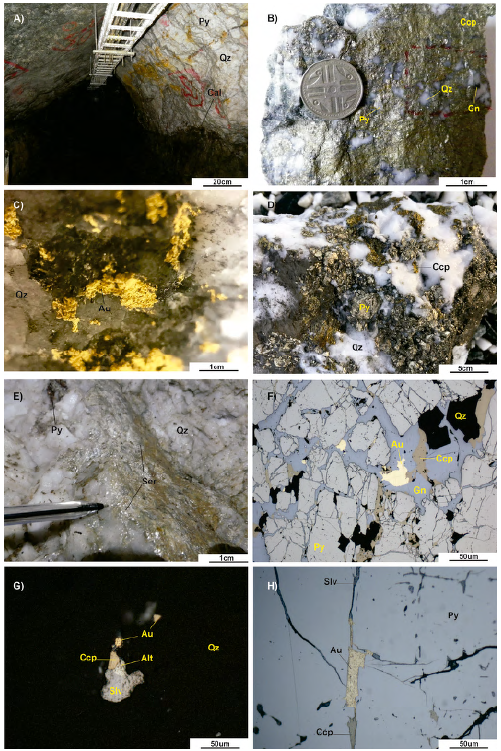
Figure 3 General view of the shear zone hosted lode gold type deposits at The El Bagre. Altaite (Alt), Calcite (Cal), Chalcopyrite (Ccp), Galena (Gn), Quartz (Qz), Pyrite (Py), Sericite (Ser) and Sylvanite (Slv). Mineral abbreviations according to Whitney and Evans (2010). A). The La Ye lode gold type deposit, with coarse pyrite, massive quartz and calcite. B). High gold grade quartz vein fragment from Mangos mine with semi-massive pyrite, chalcopyrite and fine-grained galena. C). Local visible gold at Mangos vein. D). High gold grade quartz vein fragment from the La Ye mine, with semi-massive chalcopyrite and pyrite. E). Fine-grained sericite. F). Photomicrograph with gold, galena and chalcopyrite filling fracture in coarse pyrite crystals. G). Photomicrograph with gold, sylvanite, chalcopyrite and altaite filling fracture in massive quartz. H). Photomicrograph with gold, sylvanite and chalcopyrite filling fracture in coarse pyrite crystals.
Four deformation events have been identified and described by Starling (2015); Naranjo et al., (2016); Naranjo-Sierra and Alvaran-Echeverri (2018) and Naranjo-Sierra (2019): (i) D1 deformation event forms the NS-NNW structural corridor and is probably precoce to gold mineralization (pre-Permian?). (ii) D2 deformation is mostly related to dextral shearing, generating ENE/WNW low-angle thrust faults which allow percolation of fluids and significant volumes of quartz with low contents of sulphide (mainly pyrite) as well as scarce gold mineralization (Naranjo-Sierra and Alvarán-Echeverri, 2020). (iii) D3 deformation is associated to sinistral transpressional shear with NNW/SSE trending riedel cross faults and deforms pre-existing veins. This deformation stage is related to the main phase of high-grade gold mineralization as well as base-metal and telluride ore (Naranjo-Sierra and Alvarán-Echeverri, 2020). (iv) D4 deformation covers all the post-mineralization events and is frequently recognized by presence of duplication by imbrication (stacking), pinching and offsets of the vein.
Methods
Geostatistics is the study of phenomena that vary in space and/or time (Matheron, 1963). This domain evaluates the spatial distribution of values and was originally developed for the purpose of ore deposit modeling and ore reserve estimation (Monteiro et al., 2004). The cornerstone of geostatistics is the semi-variogram function, which geostatisticians generally refer to as a variogram. Given two locations, x and (x + h), a variogram is one-half the mean square error produced by assigning the value z(x + h) to the value z(x), or the variance of the increment (Matheron, G. 1963). The semi-variogram function is expressed by the following equation:
To determine the orientation, shapes and regularity of high gold grades in lode-type deposits at the El Bagre, the geostatistics method and the semi-variogram function were applied to perform a gold grade analysis. The main goal is to integrate structural features of the orebodies and gold grade data set to reach the quantitative relation of mineralization and ore-controlling structures (Wang et al., 2019). A gold grade data set for each lode were prepared and separated between fault blocks. A total of 35.154 samples from drill holes and channel samples (samples taken perpendicular to the vein exposures inside the mine) were used for this analysis, covering 2.2km2 (Figure 4). The database was multiplied by a constant value to maintain the mining company's confidentiality. This technique does not affect or change the sample variance and range vectors and still allows a variogram analysis (Wang et al., 2019).
Gold grades in lode-type deposits may change depending to vein locations and directions, which induce significant anisotropies. These gold variations must be carefully evaluated in different directions (Miller & Wilson, 2004), helped by semi-variogram function. The backbone of semi-variogram analysis is to determine the sill or the lag distance at which the semi-variogram level off and the range or the distance at which gold grades are autocorrelative and stable. Mineralization anisotropy can be described as an ellipse with a preferred direction. The ellipse that best fits the dataset of each orebody between faults was determined during variogram modeling. The longer axis of the best-fitting ellipse indicates the orientation and distance where mineralization is stable, and the shorter axis of the ellipse indicates the orientation and distance where mineralization is unstable (Wang et al., 2019 and Monteiro, 1996). This further indicates the orientation and size of high-grade ore shoots as ore-shoots plunge in the direction where mineralization is most stable and the range is the biggest (Wang et al., 2019). Based on this, several variogram direction were conducted (00°, 020°, 040°, 060°, 080°, 100°, 120°, 140°, 160° and 180°) to define the best-fit parameters of the variogram function and to determine the directional dependency of the range value. These values were used to evaluate the shape of the ellipse that best describes the mineralization of each orebody (Figure 5).
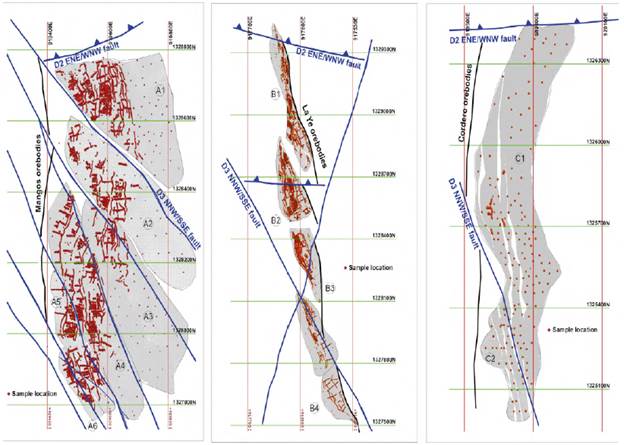
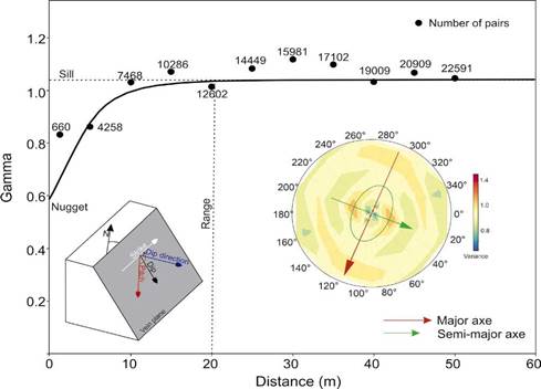
Figure 5 Variogram running along vein plane (dip direction/dip), showing the sill value at which the variogram level off, the nugget effect and the range. The ellipse on the right is the mineralization anisotropy (on vein plane) with the preferred direction (pitch direction) or the direction where gold grade is more stable.
Orebodies, ore shoots and ore-controlling structures
Orebodies at the El Bagre mining district are generally considered as the product of ore-forming fluids derived from at least two episodes of fluid flow circulating in the shear zones (Naranjo-Sierra, 2019; Naranjo-Sierra and Alvarán-Echeverri, 2020), thus indicating probable multiple mineralizing stages, associated with various orebodies and ore-shoots directions. Orebodies from La Ye, Mangos and Cordero have different orientations, shapes, and sizes. According to stereonet plots, Mangos orebodies tend to strike (as a whole) to the NS-NNE and plunge to the NE (Figure 6A), the La Ye orebodies tend to strike (as a whole) to the NNW-NS and plunge to the SW (Figure 6B) and Cordero orebodies tend to strike (as a whole) to the NNW-NS and plunge to the NE (Figure 6C). These orebodies are crosscut by late-D2 ENE-WNW and D3 NNW-SSE faults, divided these orebodies into several blocks (twelve) and for each, a stereonet plot was prepared to determine orebody tendency (Figure 5). These tendencies were used to perform the variogram map to define the pitch direction where gold grade is more stable.
The ellipses determined by variograms indicate spaces where gold grade distribution is autocorrelative, and these elliptical spaces represent individual ore-shoots (Wang et al., 2019). The mineralization anisotropy diagrams indicate two preferred pitch directions; 120°-110° and 60° for Mangos orebodies, 160° and 20° for the La Ye orebodies, and 120° pitch direction for Cordero orebodies. This anisotropy reflects the preferential direction of high grades (Figure 7).
Shear zone hosted lode-gold type mineralization at the El Bagre is characterized by an NNW/SSE and ENE/WNW trending major faults. On this fault planes, several linear elements were recognized (pitch/plunge). The sets 0°-5°/N and 110°-130°/SE indicate early sinistral reverse movement on this ore-controlling faults during D3 deformation event. The 65°N and 90°NE sets are fairly close and defined by similar striations. These two linear sets indicate later post-mineralization normal movement related to D4 deformation. Moreover, it is common to observed NW-plunging slip grooves on reactivated footwalls of the orebodies and strong fracturing with sulfides-tellurides filling due to sinistral shears and steep joints. Based on this structural controls, mineralization anisotropy and thus the direction of high gold grades are related to NNW/SSE trending faults during D3 deformation event.
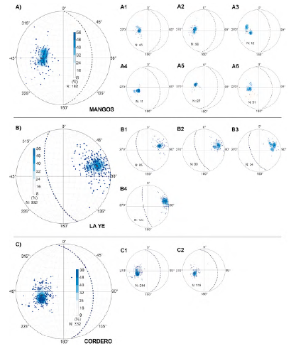
Figure 6 Stereoplots for each orebody. A) Mangos orebody divided in six fault blocks (A1 to A6). B) La Ye orebody divided in four fault blocks (B1 to B4). C) Cordero orebody divided in two fault blocks (C1 to C2). All stereoplots are low hemisphere, equal area.
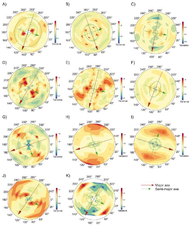
Figure 7 Variogram maps running along the vein plane (dip direction/ dip; based on stereoplots; i.e.; Figure 6), with gold anisotropy for each orebody, showing the pitch direction (on vein plane) where gold grades are most stable and therefore the ore-shoot directions. A to F). Mangos orebodies. G to J). La Ye orebodies. K). Cordero orebodies.
Discussion
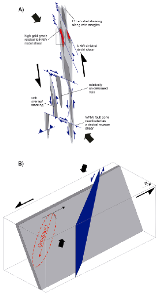
Gold mineralization at the El Bagre gold district is the result of structurally controlled mineralizing fluid flow. At orebodies scale (or metric scale), significant volumes of quartz with low contents of sulphides and scarce gold mineralization were deposited during D2 deformation event. But only where D3 deformation event is present high gold grades occurred, mostly related to NNW-SSE riedel shearing. Individual ore-shoots plunge to the SE while the orebodies plunge to the SW and NE as a whole. Although hydrothermal flow is complex and poorly constrained, the fault kinematic data suggest a link between high gold grades and NNW-SSE D3 faults. Based on this new data and previous works presented by Starling (2015); Naranjo et al., (2016); Naranjo-Sierra and Alvaran-Echeverri (2018) and Naranjo-Sierra (2019) suggest a two stages model for the emplacement of gold-bearing veins in the El Bagre district: 1) an early episode of fluid flow during NNE-SSW D2 dextral shearing, with ore-forming fluids focused on dilational sites (like right step-overs/overlaps or anti-clockwise) along the trace of main veins. 2) D3 NNWSSE deformation reactivates D2 structures with numerous sinistral shear zones and forming zones of fractured quartz, infilled by late fine-grained sulphides, gold and tellurides mineralization. D3 was the main phase of deformation that controlled much of the economic mineralization. Moreover, D3 NNW-SSE deformation faults show brittle-ductile strike-slip displacement of the vein in a sinistral sense that implies they formed as Riedel shear components to the sinistral transpressional shearing. Some of these faults display banded quartz veining that indicates that hydrothermal fluid flow was active during this event. Thus, this later D3 deformation of the pre-existing massive quartz veins created zones of enhanced permeability controlling the high gold grades and therefore the ore-shoots (Figure 8).
Conclusions
Gold mineralization in the Shear-zone hosted lode deposits at El Bagre, are structurally controlled. The ellipses of mineralization anisotropy show that ore-shoots tend to plunge to the SE while orebodies plunge to the NE and SW. Only where D3 deformation is present, high grades occurred, proving that later D3 NWW-SSE trending faults controlled the main mineralization event. Combined structural analysis with geostatistics is a valuable tool for mining exploration to determine the architecture of ore-controlling structures at deposits and district scale.

