


 English (pdf)
 Article in xml format
 Article references
 Send this article by e-mail
 Cited by SciELO
  Cited by Google
  Similars in
SciELO
Similars in
SciELO  Similars in Google
 Permalink
Introduction
Arable land is a significant resource for the livelihood of communities (Wang et al., 2021). For agriculture-based civilizations, arable land supplied basic human needs (Hanioka et al., 2018, Yang et al., 2021). During industrialization, arable land was a solid foundation for economic and social development as the carrier of production materials (Lageras and Fredh, 2020; Zhou and Lv, 2020). During ecology-centric construction, arable land can provide landscape value beyond basic resources (Liang et al., 2020; Schirpke et al., 2021). Therefore, arable land as a complex system has been involved in an aesthetic landscape function and played an important role in providing social security.
The term of arable land "red line" proposed by the Chinese government, should be strictly used as the baseline for arable land protection (Zhou and Lv, 2020; Qian et al., 2021). From an ecological landscape perspective, arable land can also contribute to an ornamental landscape (Shifaw et al., 2019). Arable land is an important factor in the rural landscape and can be used to enhance diversity with mountains and lakes (Jiang et al., 2021). Furthermore, improvements in arable land patterns can strengthen ecological protection, improve the connectivity of green spaces, and enhance the beautification of the rural landscape (Liang et al., 2020).
The concept of landscape ecology originated in the 1930s, was defined as the science and art of studying and improving the relationship between spatial patterns and ecological processes at multiple scales and organizational levels (Gao and Liu, 2021; Mansourian, 2021). Since landscape ecology was introduced in China regarded as the unity of ecology and geography, domestic scholars have achieved a lot of farmland landscape designs, aesthetics, and ecological planning incorporating Chinese characteristics (Mirghaed et al., 2020; Isik and Vessel, 2021). Along with increased research into landscape patterns, the ornamental value of the farmland landscape has become a research focus (Mirghaed et al., 2020). Most foreign scholars have focused on landscape quality and on the aesthetic value of the landscape (Schirpke et al., 2021; Yazici and Asur, 2021). Traditional research on landscape quality has involved investigation and analysis of the visual characteristics of a target area or the visual landscape of a geographic area (Gao et al, 2022; Isik and Vessel, 2021). Keywords for this research have included visual landscape quality, landscape visual quality, scenic beauty, and so on, with research content focusing on the evaluation of visual aesthetic quality (Krupowicz et al., 2020; Isik and Vessel, 2021; Yazici and Asur, 2021). Compared with foreign research, environmental impact assessments of the visual landscape in China are mainly focused on aspects including landscape design for urban planning and road aesthetics, and research methods have prioritized theoretical analysis over quantitative or spatial evaluation (Jiang et al., 2020a; Gao and Liu, 2021; Qian et al., 2021). The visual landscape is an important index for assessing aesthetic value, which will be quantified in this paper.
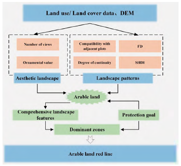
In China, arable land protection has been improved from quantitative protection to comprehensive protection of quality and landscape (Yang et al., 2020; Wang et al., 2021). The arable land red line represents the cordon of arable land protection, has ensured both stable patterns of food production and great aesthetic values for environmental protection (Sakellariou et al., 2021). Therefore, by using an evaluation index system, this study tentatively divided the landscape characteristics of the arable land red line into two categories: the aesthetic landscape characteristics and landscape patterns static characteristics (Figure 1). The main objectives of this research are to (1) evaluate the aesthetic landscape characteristics of arable land; (2) quantify the landscape pattern characteristics of arable land. And (3) establish a framework to explore comprehensive features of the arable land using an empirical model and providing a basis for the determination of the arable land red line.
Materials and methods
Study region descriptions
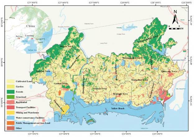
Donggang City is located between 123°22'30" and 124°22'30" E and 39°45' and 40° 15' N near the Liaodong Peninsula and the mountains of eastern Liaoning in China (Figure 2). Its geographical conditions include the Yellow Sea in the south and the Yalu River in the east. The terrain of the study area drops in elevation from north to south. The countryside is hilly in the north, low hilly areas are found in the central region, and Coastal plains with flat topography and fertile soil ideal for planting high-quality rice are distributed in the south. Donggang City is influenced by a humid monsoon climate with annual mean precipitation of 899 mm. The climate is suitable for agricultural production. Donggang City is a major rice-producing area within Liaoning Province. According to the Overall Plan of Land Utilization of Donggang City (2006-2020), arable land and primary arable land shall be less than 88,500 hm2 76,370 hm2 in 2020. The arable land resources are rich, which can not only ensure food security but also prompt a focus on ecological protection of the aesthetically pleasing scenic line in the construction and development of urban areas.
Data sources and methods
The main data sources included: (1) land survey data including land use type (e.g. ecological land, traffic routes, the urban boundary); (2) digital evaluate map (DEM) of Donggang City, which provided slope attribute data, and (3) farmland classification data, from which the arable land data were extracted.
This study analyzed the asymmetry of comprehensive landscape features, which can reveal the frequency distribution rule of each value (Xiang and Li, 1981), as listed in Equation 1.
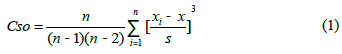
Where Cso is the deviation coefficient, n is the number of samples, x is the value of sample i, x is the median of the sample, and s is the standard deviation of the sample.
This study analyzed the influence of aesthetic landscape characteristics and landscape patterns characteristics on comprehensive characteristics using the Pearson correlation coefficient (Zhang et al., 2005), as listed in Equation 2.
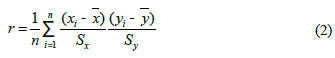
Where r is the Pearson correlation coefficient, n is the number of samples, x and y are the values of x̅ and  variables of sample i respectively, ‘x and 'y are the mean values of x and y respectively, and Sx and Sy are the standard deviations of x and y respectively.
Evaluation processes
The evaluation processes included five steps: (1) construction of the evaluation unit; (2) index selection for the aesthetic landscape characteristics; (3) index selection for landscape patterns characteristics; (4) calculation of indices score; and (5) building the evaluation model.
Construction of the evaluation unit
The evaluation unit, which is the most basic evaluation object, has internal attribute uniformity. Evaluation units have the same soil properties (e.g. organic content and surface soil texture), and the same land-use type and topography. In this study, the evaluation unit was formed by overlaying soil maps, topographic maps, and land use maps with the same spatial scale. According to this principle, all arable land plots were divided into 30,656 evaluation units using the Second National Land Survey data of Donggang City in 2012.
Aesthetic landscape characteristics of arable land
Landscape aesthetics, closely related to the landscape pattern, not only contains social and cultural values but also reflects ecological values. It should be paid attention to when carrying out resource protection and planning to give play to the aesthetic value of landscape utilization(Kerebel et al., 2019; Liu and Schroth, 2019). Landscape aesthetics can be studied quantitatively, and the commonly used methods are psychophysical (Schirpke et al., 2019). The main idea is to understand the relationship between landscape and aesthetics as a stimulus-reflective relationship (Tribot et al., 2018; Ha and Yang, 2019). Therefore, aesthetic landscape characteristics were further divided into the number of views and ornamental value.
The number of views is very important to the quality of life for current residents (a crucial factor in attracting future growth and development to the valley) (Ha and Yang, 2019). This factor was evaluated considering various viewpoints to provide a scientific basis for the aesthetic protection of the farmland landscape. This study used the access gallery and city boundary as principal viewing positions and for calculating land plot numbers. That is the number of points that can be seen from arable land by human activity sites including urban boundaries and roads, regardless of any angle. Larger numbers indicated greater visual landscape features and a significant landscape aesthetic function. Scores for the number of views were calculated using the cut-off value method.
The ornamental value of arable land is mainly based on the minimum distance from the arable land patches to regions of important natural resources. Reservoirs, seashores, and nature reserves are crucial natural resource regions and serve as important ecological barriers to land use. It is also important to protect the ecological function of arable land resources. This study calculated ornamental value scores using the cut-off value method.
Landscape patterns characteristics of arable land
Landscape pattern generally refers to its spatial pattern, that is, the spatial arrangement and combination of landscape elements of different sizes and shapes, including the type, number, and spatial distribution, and configuration of landscape components (Jiang et al., 2018, Jiang et al., 2019, Jiang et al., 2020b). Therefore, the quantitative indicators of landscape pattern characteristics in this study include compatibility with adjacent plots, degree of continuity, fractional dimension (FD), and Shannon diversity index (SHDI).
Compatibility with adjacent plots is an important index for assessing the stability of arable land resources. Greater compatibility means a lower risk of development, greater stability, and more sustainable utilization of arable land resources. Compatible plots included arable and ecological land (such as garden plots, woodlands, grassland, water areas, and beaches). Compatibility value was based on a ratio of compatible length to the total length of every arable land plot. This study calculated the score of compatibility with adjacent plots using the cut-off value method.
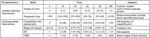
The degree of continuity is related to the scale of land use and aid in characterize agricultural landscape patterns. Thus, the continuity of arable land should be a conservation priority. In this study, the degree of continuity is taken to be the covered area of intersecting arable land resources within a 10-m buffer area. The degree of continuity was calculated using the cut-off value method.
FD is a landscape pattern index measuring the shape of landscape patches, and the FD values of each arable land patch were calculated according to Equation 3. FD values theoretically range from 1.0 to 2.0. Values close to 1.0 indicate stronger self-similarity and geometric rules, as well as greater effects of human disturbance (Frohn, 1997). FD scores were calculated using the cutoff value method.
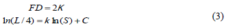
where FD is the fractional dimension, L is the perimeter, S is the area, к is the slope of the regression system, and С is the offset.
The SHDI is based on information theory and reveals landscape heterogeneity. It is especially sensitive to the unbalanced distribution of various types of patches. The SHDI values of each arable land patch were calculated according to Equation 4. The SHDI emphasizes the contribution of rare patches. Furthermore, SHDI is a biochemical indicator for the comparison and analysis of changes in diversity and heterogeneity over different periods. When SHDI equals 0, the whole landscape consists only of one plot. A larger SHDI value indicates balance and diversity in the distribution of patch types (Shannon and Weaver, 1998). In this study, scores were calculated using the cut-off value method.
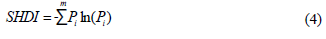
where SHDI is the Shannon diversity index, m is the number of patch types, and P i is the area of land type i.
Calculation of indices score
This study divided the indices into ranges and calculated their scores using the cut-off value method (Table 1).
Evaluation model construction
The assessment model was based on a multi-factor comprehensive evaluation method (Saaty, 1988), as summarized in Equation 5.
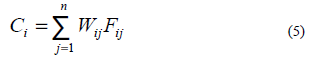
where Ci is the comprehensive score of evaluation unit i, Fij is the score of evaluation unit i for evaluation factor j, and W ij is the weight of evaluation unit i for evaluation factor j.
The evaluation methods for index weight primarily included the analytical hierarchy process (AHP) and expert scoring method (Table 2).
Results and Discussion
Evaluation analysis of aesthetic landscape characteristics
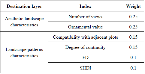
The aesthetic landscape is a significant perspective in landscape protection that can reflect the aesthetic value of arable land resources. In this study, aesthetic landscape characteristics were analyzed using the number of views and ornamental value. This study synthetically analyzed the aesthetic landscape characteristics (Figure 3a) and further analyzed features of the number of views (Figure 3b) and ornamental value (Figure 3c). From Figure 3a, aesthetic landscape characteristics scores were mainly distributed within the range of 76-88. The greatest-scoring areas were located around the city center, along both sides of arterial traffic, and adjacent to important natural resources. Arable land in those regions had a greater number of views and ornamental value. Areas with dynamic characteristic scores greater than 80 covered approximately 22,659 hm2, primarily distributed along both sides of China National Highway 201, and near-coastal benched and other water areas located in the jurisdictions of Haiyanghong Farm, Huangtukan Farm, Donggang City Economic Zone, and Xinglong Farm. The arable land in these regions was considered to have the best visual landscape with an aesthetic scenic line. This feature can also be incorporated into the red line to control the boundary of urban development. The visual landscape is beneficial to the group- and series-type urban development, as it helps prevent a 'street city' condition in which all cities are connected directly without a buffer zone (e.g. farmland or forest).
(Source: farmland classification map of Donggang City in 2012)
Figure 3 Aesthetic landscape characteristics(a) and explanatory variables: number of views (b) and ornamental value(c) of arable land in Donggang City
The number of views ranged from 0 to 606. In the north, the area with a view score equal to 100 covered approximately 3,980 hm2 and was distributed primarily around the Danda highway. In the south, the area scoring 100, covered approximately 14,216 hm2 and was distributed in peri-urban areas, and along both sides of the roadway. Scores in the north were significantly lower than those in the south owing to the more complex terrain in the northeast. In the north, low mountains, and hilly land block the line of sight. The south has an open field of vision, along with the main traffic corridors. The city center is also located in the southeast and relates to these roadways. Thus, arable land resources in the south had greater view scores. The area of these high-scoring regions, distributed along the perimeter of the center and on both sides of arterial traffic, covered approximately 9,210 hm2. These regions also exhibited higher-quality natural conditions and location advantages. At the policy level, the recommended arable land red line in this region satisfied the construction needs for permanent capital farmland. In terms of the visual landscape, arable land in this area is indispensable. Thus, the aesthetic value and red-line function of arable land resources are consistent.
The ornamental value of arable land was mainly based on the distance from patches of arable land to important natural resources. These distances ranged from 0 to 7,474 m, with a mean distance of approximately 247 m. The important natural resources of Donggang City are mainly distributed in the north and along the southern coast. The areas with ornamental scores of 100 cover approximately 24,709 hm2. These regions should be classified as ecological conservation areas. Arable land in this region, reliant upon the natural terrain, maintains the continuity of the natural landscape and, in conjunction with the adjacent landscape, can provide valuable ecological services.
Evaluation analysis of landscape pattern characteristics
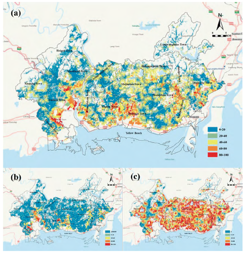
The landscape pattern characteristics mainly reflect the diversity and disturbance degree of the landscape, which in turn indicates the stability and degree of development and utilization of the land. In this study, landscape pattern characteristics were analyzed by their compatibility with adjacent plots, degree of continuity, FD, and SHDI. A higher score meant greater permanence and stability and prominent landscape characteristics (Figure 4a), and further analyzed the features of compatibility with adjacent plots (Figure 4b), FD (Figure 4c) degree of continuity (Figure 4d), and SHDI (Figure 4e). Landscape pattern characteristics scores were mainly distributed between 70 and 82. The area with scores greater than 75 covered approximately 12,931 hm2, mostly distributed in the jurisdictions of Wusi Farm, Xiaomianzi Town, Beijingzi Town, and Changshan Town. Arable land in the high-scoring region exhibited less conflict with adjacent plots, greater compatibility and continuity, a more regular shape, and a more stable ecosystem. The arable land of these regions should be well-maintained to reduce the impacts of human activity and should be incorporated into the permanent prime farmland area.
(Source: farmland classification map of Donggang in 2012)
Figure 4 landscape pattern characteristics(a) and explanatory variables: compatibility with adjacent plots (b), FD (c), contiguous total area (d), and SHDI (d) of arable land in Donggang City
In terms of compatibility with adjacent plots, proportions ranged from 0 to 1. There were approximately 14,186 plots with a value of 1. The arable lands in these areas had greater stability, continuity with the adjacent ecological land, protection of biodiversity, and overall environmental quality. The best-scoring jurisdiction was Shifan Farm, in which 97.26% of arable lands had a value of 1, followed by the jurisdictions of Haiyanghong Farm, Xiaomianzi Town, Changshan Town, and Heigou Town.
The contiguous total area of arable land which the buffer intersects ranged between 0.06 and 242.94 hm2. In the northwest arid areas, arable land had low contiguity, and the mean contiguous area was approximately 2.22 hm2. In the southeastern coastal areas, the mean contiguous area was approximately 5.74 hm2. This area hosts abundant water resources, and the arable land comprises mostly paddy fields. The most contiguous jurisdiction was the Developed Zone, where the mean contiguous area was 6.79 hm2, followed by the jurisdictions of Wusi Farm, Dadong Office, Beijingzi Town, and Changshan Town. Arable land with a greater degree of continuity has prominent landscape characteristics and greater stability and makes greater use of scale.
FD values ranged from 1 to 1.39. Lower scores indicated that arable land had greater self-similarity and stability and more geometric rules. Regular patches of arable land also have greater aesthetic value than do irregular patches at large scales. The region with FD scores of 100 was mostly distributed around the city center and along both sides of arterial traffic in the southeast of Donggang City and included the jurisdictions of Xinglong Farm, Wusi Farm, Beijingzi Town, and Changshan Town.
SHDI values ranged from 1.1194 to 1.8846. The number of patches with scores of 100 was approximately 97.26%. Greater SHDI values indicate balanced land utilization, a stable ecological system, and a high-quality ecological environment. The areas with high SHDI values included the jurisdictions of Xincheng Office, Dadong Office, the Developed Zone, Huangtukan Farm, Shifan Farm, Wusi Farm, Xinxing Office, and Xinglong Farm. These regions should be priorities in the protection of landscape pattern characteristics.
Evaluation analysis of comprehensive landscape features
In terms of the comprehensive landscape features, uniform distribution ranged from 0 to 606, with a standard deviation of 16.835, and asymmetry was -0.073 (Equation 1). The correlation with the aesthetic landscape characteristics was 0.852 (Equation 2), and the correlation with landscape pattern characteristics was 0.609. Thus, the effect of aesthetic landscape characteristics was relatively prominent, indicating that aesthetic features of arable land resources are important in determining the arable land red line.
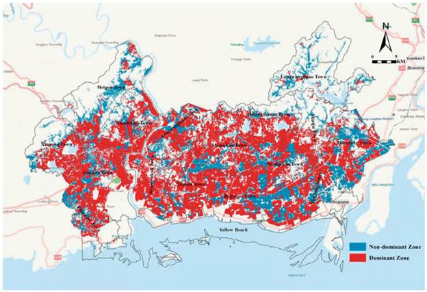
This research divides the dominant zones and non-dominant zones according to the arable land protection objectives issued by the higher-level government. The node is a comprehensive value of 42, which can be used as the best choice for permanent basic farmland. As shown in Figure 5, the areas with comprehensive landscape features scores greater than 42 covered approximately 88,027.21 hm2. In the south, this area covered approximately 49,570.56 hm2. In the north, this area covered approximately 38,456.62 hm2. This region was located along the perimeter of the central city and on both sides of arterial traffic and adjacent to important natural resources. These areas, which can be classified as permanent basic farmland not only have a low-relief surface, broad visibility, and greater ornamental value, but also regular shape, greater continuity, greater stability, and greater use of scale. Aesthetic landscape characteristics are prominent in the dominant landscape area, of which the value of the number of views ranged from 41 to 606, and the ornamental value ranged from 0 to 638.61. Meanwhile, the index of the compatibility with adjacent plots and SHDI are advantages in the landscape pattern characteristics, with values ranging from 0.87 to 0 and 1.81 to 1.88, respectively. Therefore, in the recommendations for the arable land red line, not only the resource value of arable land should be protected but also the landscape value.
Conclusion
The result showed that the arable land red line is not only a quantitative line for ensuring food security, but also has a landscape value. This study discussed the aesthetic value of arable land resources through assessing the aesthetic landscape characteristics and landscape pattern characteristics. Finally, the comprehensive landscape features of arable land resources wereB discussed, and the distribution of dominant landscape features was confirmed.
The result confirms that arable land with greater aesthetic landscape characteristics is distributed around the city center, along the sides of arterial traffic, and adjacent to important natural resources. This area covered approximately 81.80% of arable land in Donggang City. Arable land with stable landscape patterns is distributed on plain terrain, which covered approximately 87.77% of arable land in Donggang City. The arable land in this region comprises mostly paddy fields and has greater continuity and compatibility with adjacent plots. The evaluation of dominant landscape features found that areas with better visual features and stable landscape patterns covered approximately 79.13% of arable land in Donggang City. From these findings, the paper recommends that the arable land red line should consider the aesthetic value and landscape patterns of arable land.
In this study, we evaluated the landscape value of the arable land red line, using limited indices of aesthetic and landscape patterns features in a typical region of China. Further study will include a more comprehensive index that considers a larger scale. In addition, index differences will also be considered for different geomorphological regions.

