


 English (pdf)
 Article in xml format
 Article references
 Send this article by e-mail
 Cited by SciELO
  Cited by Google
  Similars in
SciELO
Similars in
SciELO  Similars in Google
 Permalink
1. Introduction
The geological body refers to the natural objects with spatial forms formed in the geological era. Geological bodies are often irregular objects, showing a natural, arbitrary geometry and size. Geological bodies can be divided into geological forms, including ore bodies, reef shoals, rock mounds, sand bodies, karst caves, and faults (Sun et al., 2018). Unlike other parts of the stratum, the geological body usually occupies a space volume and greatly differs from other geological components in the same stratum (Montanari et al., 2017). An abnormal geological body is a part of the concept of geological bodies. The geological anomaly body has all the characteristics of the geological body but also has some of its own. In the authors' geological exploration and geophysical research, the range of abnormal geological bodies is different from other areas in many aspects, such as the mutation of vibration amplitude and the mutation of the waveform shape (Wu et al., 2017). Geological anomaly bodies play an essential role in many geological structures. The exploration and research of geological anomaly bodies play an active role in the inference of geochemical and geophysical anomalies (Li et al., 2019). Geochemical and geophysical anomalies are often caused by mineralization, which is the effect of variation of local chemical and physical fields in the area during the formation of the deposit, and often serves as a sign of the existence of the deposit (Ping et al., 2017). There are many important geological resources such as oil and natural gas in common geological abnormal bodies such as river courses and sand bodies (Zhu et al., 2018). Therefore, in geophysical exploration and structural interpretation of geological data, geological anomalies will be specifically detected, identified, and visualized (Bai et al., 2018). Given the above characteristics and significance, geologists and researchers have done much research and achieved good results (Han et al., 2020; Zhang et al., 2019).
Structural interpretation of geological data covers almost all scientific research fields of petroleum and basic geology, including structural stratigraphy, seismic stratigraphy, and other disciplines. Three-dimensional visualization technology can directly show the results of structural interpretation and other geological structure research. It can help geologists and relevant researchers better understand the geological characteristics of the surface and below the surface to better carry out subsequent research (Liu et al., 2017). The research and visualization of 3D object surface reconstruction are one of the most important technologies of 3D visualization, which is widely used in the fields of geological exploration, environmental science, aerospace, health care, remote sensing, and geophysical exploration. Wang Xiangsheng proposed to use the geological radar to detect the geology, but the detection of this method is time-consuming and inefficient; Liu Mingyang applied the electrical method to the geological survey of water conservancy engineering, but the survey accuracy of this method is controversial, and lack of case verification; Han Kunying and other scholars designed an automatic inspection system of geological map spatial database to apply in the geological exploration. This paper recognizes that a matching detection method should be introduced for this system to achieve high-precision detection of geological anomalies (Xu & Chen, 2019).
Nowadays, 3D visualization technology is a research hotspot of all kinds of geological and seismic software. It is a tool for intuitively expressing and displaying many geological features on and below the surface. Geologists and researchers can use three-dimensional visualization software to display the results of seismic research and understand the geological structure more intuitively to pave the way for further research. In this paper, the authors propose a method of detecting the geological anomalies in urban underground space based on feature fusion. Firstly, they built a three-dimensional grid data model for attribute information modeling and visualization of urban underground space to obtain the geological features of urban underground space in the UK. Then, they used the method of extracting the multi-attribute anomaly data to detect the geological anomalies in urban underground space in the UK (Peng et al., 2018).
2. Materials and methods
2.1. The 3D raster data model for attribute information modeling and visualization of urban underground space
The data of physical and chemical attribute parameters (such as stress, porosity, permeability, water quality, and water temperature) in urban underground space geological bodies differ from the information of spatial geometry structure. They are generally the continuous change (gradual change) in three-dimensional space. It is necessary to model and analyze the attribute data in the geological body and study its space. Generally, the three-dimensional volume element model can be used to segment the underground space entity to form the corresponding volume element. Then the specific spatial interpolation method and visualization algorithm can be used for analysis. Different volume element segmentation methods and data models can be used according to research objectives, such as the three-dimensional grid, octree, and tetrahedron models. This paper uses a three-dimensional grid model to process the physical and chemical attribute parameter data modeling of urban underground space geological bodies (Gao et al., 2018).
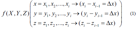
The 3D grid model uses a set of regular-size 3D grids (cubes) to segment the space which will be simulated and establish a real-time association with attribute information. In the three-dimensional grid data model, the three-dimensional grid is the basic unit to store the voiceless attribute information inside the geological body, and it is assumed that the function value of the physical and chemical attribute data field is distributed on the eight vertices of the grid, that is, the function value at the vertex (X i ,Y j, Z l ) is f. (X i Y j ,Z l )Therefore, the volume data in the storage and grid can be defined as a sampling function in a discrete bounded three-dimensional space, and the sampling is structured by structure; that is, the volume data is regular structured, and the sampling is uniform in three directions of space, which can be expressed as:
With this kind of 3D grid data model, the analysis of spatial attribute data in the geological body can be attributed to the analysis of attribute data among 3D grids, as the visualization technology can also be applied to the 3D visualization of data field represented by the 3D grid data model to analyze the spatial distribution of an attribute value (Singh et al., 2017).
In this paper, when using the 3D grid model to represent spatial attribute data, each vertex of the 3D grid stores two attribute data (u,v), where u represents the stratum number of the grid vertex, and v represents the physical and chemical attributes at the location of the grid vertex. In this way, the set of vertices with the same stratum number can represent the spatial position and shape of the corresponding stratum. This model can represent not only geological bodies and their attributes with complex morphology and topological structure but also analyze spatial attributes under the constraints of geological body set structure, providing constraints on spatial set structure for direct volume rendering of spatial attributes (Gao, 2018).
2.2. Feature-level fusion extraction method of geological anomaly based on multi-attribute
In order to analyze the related problems of the underground geological abnormal body, it is necessary to introduce a cause of that body. Therefore, this paper takes the earthquake as the cause of the abnormal body. Based on the underground geological data extracted from the 3D grid data model of urban underground spatial attribute information modeling and visualization constructed in Section 2.1, it adopts the method of multi-attribute data fusion to extract the abnormal body, to improve the characteristics of abnormal geological bodies in underground space and integrate them to achieve high-precision abnormal body detection (Sheth et al., 2018).
Because of the complexity of the data, it is often unable to reflect all the features and details of the geological structure from a single geological attribute, so it is essential to interpret the geological structure with different geological attributes. One of the characteristics of geological data is that the amount of data is vast, tens or even hundreds of G. If it is fused directly, it will produce a great deal of computation, which ordinary computer systems cannot process. Therefore, this paper proposes a feature-level fusion extraction algorithm based on a multi-attribute geological anomaly body, roughly divided into two steps: the feature extraction of multi-attribute data and the anomaly body fusion of multi-attribute data (Shrestha et al., 2017).
2.2.1. Feature extraction of multi-attribute data of abnormal body based on human-computer interaction
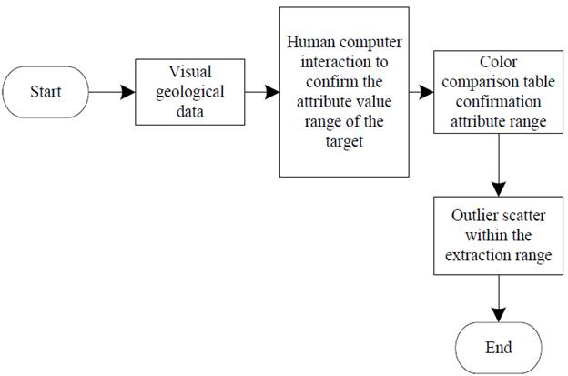
Researchers are usually more interested in geological structures. When dealing with multiple geological attribute data, they only need to extract their feature points for research. In this paper, the feature extraction method of multi-geological attributes is based on human-computer interaction, which requires users to observe and analyze each geological data, select the range of geological attribute values of interest, and extract the scattered points of geological anomalies within the range.
This paper introduces the feature extraction of abnormal bodies based on multi-attribute human-computer interaction data. Firstly, open the geological texture attribute data and visualize it. Secondly, using "karst cave" as an example, human-computer interaction observation data finds the "karst cave" structure. Thirdly, contrast the color table to find its attribute range. Finally, extract the abnormal-scattered points within the range. Figure 1 is the flow diagram of the process:
2.2.2. Feature fusion of multi-attribute data based on fuzzy logic
After the feature extraction of multiple geological attribute data, these features need to be fused to get the scattered point data of the geological anomaly body. The data of the integrated abnormal body contains the characteristics of multiple geological attributes, which reflect the different geological characteristics of the abnormal body according to the user's emphasis on different attributes. The multi-attribute geological anomaly fusion extraction method in this paper is based on fuzzy logic reasoning. It requires users to set the importance of different geological attribute data according to their objectives to get the ideal effect of anomaly fusion extraction.
The fuzzy set was put forward by L. A. Zadeh, an American cybernetic expert, in 1965. Since the birth of fuzzy set theory, the rapid development of the fuzzy logic system has played a role in pattern recognition, signal processing, health care, and other fields, providing great help for related research. Common fuzzy inference systems are divided into three categories: pure fuzzy inference system, Mamdani type fuzzy inference system, and Takagi Sugeno type fuzzy inference system. This paper is based on T-S fuzzy inference. The reasoning process of T-S Type Fuzzy includes the fuzzy operation, and its output is an exact value. This is determined by the form of T-S fuzzy reasoning itself (Cotterilletal.,2017).
Outlier feature fusion is divided into four steps based on fuzzy logic: Initialization, setting parameter list, and reading outlier feature scatter. Spatial scatter registration. Feature scatter fusion. And binary operation. The flow chart is shown in Figure 2.
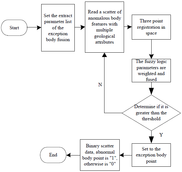
In order to solve the problem of the feature fusion and extraction of abnormal geological bodies, the Analytic Hierarchy Process (AHP) based on fuzzy reasoning is used to fuse the features of multiple geological attribute data. The factor set for the abnormal geological body is "0". The "1" values on each grid point of each geological attribute data and the value of each grid point obtained after the feature data scatter fusion operation is the final comment set. The focus of this paper is how to extract the geological abnormal body feature scatter point data from each different geological attribute. The factor set is the comment set formed by the scattered points that belong to the target after the fusion. Due to the scattered points of geological anomalies have the following characteristics, the value of each grid point is either "0" (the point is the background point) or "1" (the point is the scattered point of geological anomalies), the authors use the fuzzy reasoning algorithm to process the scattered point data of geological anomalies. At this point, adjustments and simplifications to the fusion algorithm were necessary to adapt to the actual seismic interpretation. In short, multi-geological attribute data feature-fusion aims to merge multi groups of 3D grid data into a new group and binary these values. The threshold rule must be formulated according to the characteristics of geological data to meet the integration requirements of our subjective interpretation experience combined with the actual geological data (Olson et al., 2017).
2.2.3. Abnormal volume data filling and surface smoothing
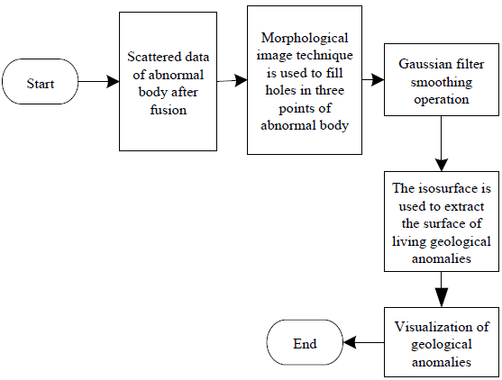
Because of the noise interference and the influence of the accuracy of the geological acquisition data, the abnormal geological bodies obtained by the proposed method are often not satisfactory enough. There are many burrs and some "holes" inside the abnormal geological bodies, which are not continuous. Then, some treatments are necessary to fill the holes and smooth the surface. Based on this purpose, this paper suggests a new algorithm flow for filling and smoothing the scattered point data of abnormal bodies suitable for geological data interpretation, which has had a good effect on the surface smoothing of geological structures. Figure 3 is the flow of filling and smoothing the data of three-dimensional geological abnormal bodies.
Firstly, a binary morphological operation is carried out to fill the small holes in the abnormal body and remove the redundant data points on the boundary of the abnormal body for the scattered point data after the previous step of multi-geological attribute feature fusion. Secondly, the Gaussian filtering method is used to smooth the scattered point data of the abnormal geological body. Finally, the moving cube algorithm is used to find the surface of the isosurface as a three-dimensional geological anomaly body.
In the process of morphological processing, this paper uses the expansion and corrosion algorithm. The corrosion algorithm can be summarized into three steps:
Taking the cube of size as the structural element and scanning the scattered point data of each spatial geological anomaly successively;
The structural elements are fused with the scattered data ofthe abnormal body in the covered area;
If all of them are valid outlier data (represented by " 1"), then this point in the result is valid. Otherwise, it is not a valid outlier scatter (represented by "0"). This operation reduces the scattered point boundary ofthe abnormal body by one circle and removes the small and meaningless objects inside the target.
The expansion operation algorithm used in this paper includes the following three steps:
Like the corrosion operation, the cube is used as the structural element to scan the scattered point data of each spatial geological anomaly body in turn
Make "or" calculation on scattered points of structural elements and geological abnormal body data in the covered area;
If there are invalid outliers (represented by "0"), this point in the result is not regarded as an outlier. Otherwise, it is an outlier (represented by "1"). The result of this operation is that the small "holes" inside the abnormal geological body are filled to make it more complete.
3. Results
Britain is the first country in the world to develop and utilize underground space on a large scale comprehensively. In 1845, Charles Pearson, an Englishman, first proposed the "underground train" concept. Eighteen years later, London built the world's first subway. With the development of the subway, underground shopping malls, commercial streets, apartments, and parking lots have emerged in succession. At the same time, due to the cold climate in Britain, cellar construction is relatively standard. For example, most of the houses in central London have basements. With the increase in the land price, the development of underground space is more common, which causes many practical problems, such as the impact of underground space excavation on the safety of adjacent buildings. For this reason, the method in this paper is used to detect the underground geological anomalies in London and Sheffield.
3.1. Feature extraction results
The ESDA-GIS-based feature extraction method of complex karst surface subsidence area and multi-source information integration-based drilling geological feature parameter estimation and prediction as the comparison method were tested several times to extract and compare the comprehensive characteristics of underground space in London and Sheffield, UK. The comparison results are shown in Figures 4 and 5.
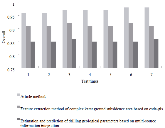
Figure 4 Comprehensive comparison results of extraction of geological characteristics of underground space in London, UK.
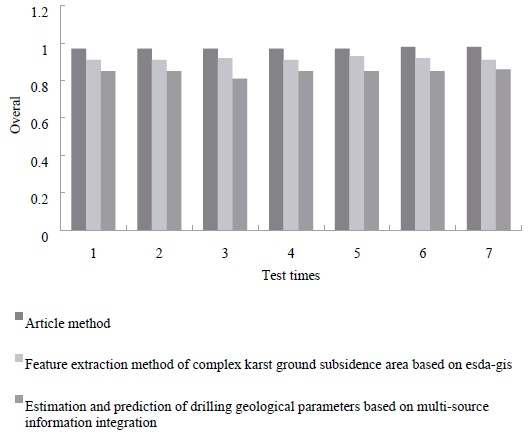
Figure 5 Comprehensive comparison results of extraction of geological characteristics of underground space in Sheffield, UK.
It can be seen from the above figure that there are some differences in the extraction of geological characteristics of underground space between London and Sheffield. In this method, the total coefficient of extracting geological characteristics of underground space in London and Sheffield, UK is always the largest, and both are as high as 0.98. The total coefficient of extracting characteristics of complex karst surface subsidence area supported by ESDA-GIS and the estimation and prediction of geological parameters of drilling based on the integration of multi-source information are always lower than that of this method. When extracting the geological characteristics of underground space in London and Sheffield, the scope of extraction is more comprehensive, which provides a reasonable basis for the follow-up study.
3.2. Feature fusion results
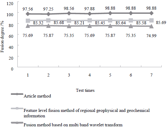
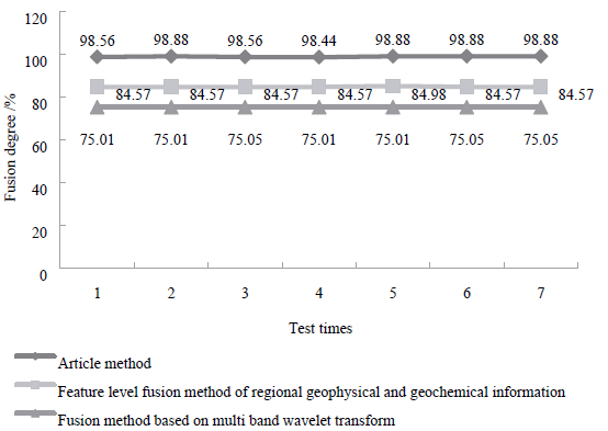
In order, the regional geophysical and geochemical information feature-level fusion method, the fusion method based on multi-band wavelet transform, and the method in this paper are used to fuse the underground space geological features of London and Sheffield in the United Kingdom as explained in the 3.1 section. The fusion effect of the three methods is analyzed, and the fusion degree is taken as the comparison index. The comparison results are shown in Figures 6 and 7.
3.3. Abnormal body detection results
Based on the detection accuracy of abnormal bodies and the surface smoothness of the detection results, the detection effect of this method on the underground space geological abnormal bodies in London and Sheffield is analyzed. The results are shown in Figures 8 and 9.
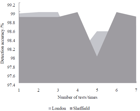
Figure 8 Detection accuracies of underground geological anomalies in London and Sheffield in this paper
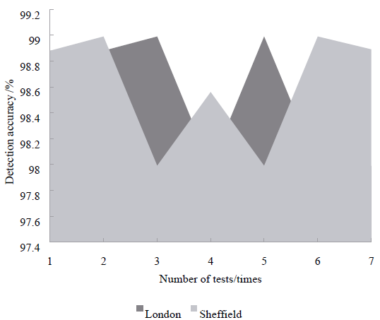
Figure 9 In this paper, the surface smoothness of geological anomalies detected in underground space in London and Sheffield was studied
It can be seen from the above figure that the highest fusion degree of the method in this paper is 98.88% and 98.88% for the geological characteristics of underground space in London and Sheffield, UK. The highest fusion degree of the regional geophysical and geochemical information feature-level fusion method for the geological characteristics of underground space in London and Sheffield is 85.69% and 84.98%, respectively.
According to Figures 8 and 9, the minimum detection accuracy of the method in this paper is not less than 97% for the geological anomalies in London and Sheffield, and the surface smoothness of the method in this paper is higher than 97%. Therefore, this paper's method can detect high-precision geological abnormal bodies in urban underground space, and the surface ofthe abnormal body is smooth and complete.
3.4. Application efficiency test
The detection of geological abnormal body in underground space needs to be realized in a short time to realize disaster prevention in natural disasters such as earthquakes. Therefore, the application efficiency of the method in the above experiments is tested, and the results are shown in Table 1.
Table 1 Application efficiency test results of the method in this paper (unit: Ms)
| Test Times | The Data Collection | Feature Extraction | Characteristics of the Fusion | Abnormal Body Detection |
| 1 | 105.25 | 101.51 | 139.54 | 128.58 |
| 2 | 105.24 | 101.23 | 139.58 | 128.69 |
| 3 | 105.25 | 101.22 | 139.52 | 128.45 |
| 4 | 105.24 | 101.51 | 139.58 | 128.25 |
| 5 | 105.25 | 101.23 | 139.52 | 128.45 |
| 6 | 105.25 | 101.22 | 139.58 | 128.25 |
| 7 | 105.25 | 101.22 | 139.52 | 128.45 |
| The Mean | 105.25 | 101.31 | 139.55 | 128.45 |
It can be seen from the data in the table that the average time consumption of this method in underground space geological data collection, feature extraction, feature fusion, and abnormal physical examination is 105.25 ms, 101.31 ms, 139.55 ms, and 128.45 ms. The overall application efficiency is (105.25 ms+101.31 ms+139.55 ms+128.45 ms) / 4=150.75 ms. It takes less time and can meet the needs of underground geological anomaly detection.
4. Discussions
Britain is the birthplace of the modern administrative licensing legal system. Its relatively complete planning and management system for the development and utilization of underground space is of reference significance for China to establish and improve the planning and management system of underground space. Based on the above analysis of the relevant legal system and underground engineering planning and management in the United Kingdom, the experiences can be mainly summarized as follows:
(1) Considering that the development and utilization of underground space is a gradual process involving many fields and related departments, the construction of relevant laws and regulations is often scattered in the relevant laws and regulations rather than forming comprehensive legislation at the national level at the beginning. Britain is the first country to carry out the practice of underground space development and utilization, but it has not formed a comprehensive law of underground space. On the one hand, this is related to the local differences in the development and utilization of underground space, i.e., the areas with more underground space development are still a few urban areas. On the other hand, the purpose of underground space development is mainly based on various specific requirements such as real estate profits, city scale, and climate reasons. The central or local government will issue various special laws, standards, rules, and other changes according to the situation. It is fast and can guide practice better. In 2011, the British Parliament passed the underground development and utilization bill, which reflects the demand for comprehensive legislation with the increase of underground space development and utilization. However, the relevant provisions and practical experience of various national and local laws and regulations in the United Kingdom in the past 150 years have undoubtedly laid a solid foundation for formulating comprehensive legislation.
(2) Considering the different types of underground engineering, it is advisable to classify and carry out professional management. For underground space development projects of different natures, the project scale is often quite different (for example, the difference between the investment and construction scales of a common family basement and large-scale infrastructure has several orders of magnitude), and the technical requirements of the project (such as traffic assessment and construction safety) are the key to approval. Therefore, different underground space projects should develop different planning and management procedures. In the UK, underground engineering is divided into general engineering, major infrastructure, and underground transportation facilities, and different review and approval subjects, procedures, and elements are established. Local governments or planning departments have further made detailed regulations suitable for the region. It is worth noting that the planning and management cycle of major infrastructure is relatively long, it takes 28 days for the review team to examine the application, and then it takes another three months for the review team to conduct the review and the relevant ministers of state to make a decision, which shows that the review decision of primary infrastructure underground should be cautious, even at the cost of time. This idea of classified management is worth learning (Pang et al., 2018). The latest regulations of Shanghai on planning and construction of underground space issued in 2014 also made similar provisions, divided into "key areas" and "other areas," and distinguished in planning formulation, planning content, scheme design, license management, and other aspects.
(3) Considering the closed nature of underground engineering, limited by geological and hydrological conditions, complex and unpredictable underground conditions, and the interaction between the above-ground and underground development and utilization, the preliminary investigation, research, and evaluation of underground space development and utilization is essential (Pang et al., 2020). In the planning and management of underground space, great importance is attached to the investigation and evaluation work in the early stage, mainly reflected in the requirements of application elements. Even for general underground engineering, the application materials shall include all kinds of research and evaluation reports on existing buildings, structural stability, geological conditions, surrounding influence, traffic influence, environmental influence, hydrogeological influence, safety, and sudden danger (Wang et al., 2019).
(4) In consideration of the impact of underground works on surrounding owners and the public, the planning and management process of underground works should pay attention to the publicity of schemes and relevant information, the solicitation of opinions from relevant owners, and the maintenance of public interests (Xu et al., 2020). Although the ownership of the general underground space development in the UK belongs to the land owner, the owners' interests around it must be maintained, and unnecessary disputes should be avoided. Therefore, in the program design process, the owners' consent within 9 meters should be obtained in the preliminary preparation stage, and the owners within 50 meters should be ensured in the review and construction stage. For major infrastructure construction, according to the planning and Compulsory Purchase Act 2004 and the Planning Act 2008, the British public sector or the government can compulsorily purchase private underground space according to the public needs and compensate according to the market value at that time. Therefore, the national essential underground large-scale infrastructure facilities are often owned by the state; or their use rights enjoy their respective parts according to the agreement of public-private cooperation to ensure the public interest. However, in this process, the opinions and attitudes of the media, the public, and community organizations can still significantly affect the project's approval.
5. Conclusion
In this paper, authors proposed a method of detecting the geological anomalies of urban underground space based on feature-fusion in the United Kingdom, tested the geological anomalies of urban underground space in London and Sheffield in England, and drew the following conclusions:
Compared with the same method, the overall coefficient of the method is the largest in London and Sheffield, and it is as high as 0.98;
The highest fusion degree of underground space geological characteristics of London and Sheffield is 98.88% and 98.88%, respectively;
The minimum detection accuracy of geological anomalies in London and Sheffield is not less than 97%. The surface smoothness of geological anomalies in London and Sheffield is higher than 97%;
This method's overall average application time is only 150.75 ms, which can achieve high-precision and high-efficiency detection of geological anomalies in underground space.
With the continuous development of modern geoscience, the technicians engaged in geological experiments and tests are also faced with more challenges. The material composition of the objects to be analyzed will be gradually complicated. Geologists should attach great importance to the extraction of abnormal information and innovate analytical chemistry theory by applying physics, geological chemistry, and other multi-disciplinary knowledge. It also takes this as a breakthrough point, integrating the geological experiment testing resources to innovate more operable geological experiment testing technologies and methods and improve the level of geological experiment testing.

