


 Inglês (pdf)
 Artigo em XML
 Referências do artigo
 Enviar este artigo por email
 Citado por SciELO
  Citado por Google
  Similares em
SciELO
Similares em
SciELO  Similares em Google
 Permalink
1. Introduction
Soil degradation by erosion is one of the most important problems affecting both natural ecosystems and agroecosystems worldwide (Panagos et al., 2018; Borrelli et al, 2020; Sharda et al, 2021). This process consists of the gradual loss of the surface layer of the soil due to the action of wind or water (Borrelli et al, 2017; Ma et al, 2021), which has led to the reduction of its productive potential, generating negative effects not only environmental but also socioeconomic (Pandey et al, 2021).
Erosion is a natural process that is caused by the combination of several factors such as steep slopes, climate, soil characteristics, type, and state of general cover. In turn, it is a process that is accelerated by the influence of anthropic activities (clean crops, planting in favor of the slope, extensive livestock, absence of conservation practices) (Amundson et al., 2015; Abdulkareem et al., 2019), and that is of great importance if one takes into account that the soil is a non-renewable natural resource
Thus, world food production is threatened by soil erosion, a figure that reaches average values of 30 t ha- 1 year -1, which leaves around 10 million hectares of unproductive farmland each year (Gachene et al, 2020). It has been pointed out that this phenomenon can cause annual socioeconomic losses of approximately 40 billion dollars worldwide (Crosson, 1995; Oldeman et al., 2017), and in environmental terms, likely, more than 90% of the soil of the planet earth deteriorates in 2050 (Bouma and Montanarella, 2016; Keesstra et al., 2016). On the other hand, approximately 48% of soils have already been degraded in Colombia (IDEAM and UDCA, 2015)
According to the above, over the last decades, research has been carried out through experimentation and modeling of erosion, which allows for counteracting its effects (Ma et al, 2021). In most experimental methods, soil erosion is calculated either in runoff plots under natural rainfall or under simulated conditions (El Kateb et al, 2013; Anache et al, 2017). However, erosion predictions can be carried out by taking advantage of mathematical models that express the efficiency of sediment transport from a hillside and a network of channels (Kirkby and Morgan, 1980; Németová et al, 2020).
The prediction of erosion has a long history of more than seven decades (Bennett, 1939; Alewell et al, 2019), where one of the most used models is the USLE, taking into account its high degree of flexibility, data accessibility, and comparability of results that allow adapting the model to almost all types of conditions in the world (Alewell et al, 2019).
This equation was developed in the 1950s, by the United States Department of Agriculture and the Soil Conservation Service, and is one ofthe most important tools in conservation planning, helping to predict soil loss (Meinen and Robinson, 2021), even at the basin level when integrated with geographic information systems (GIS) (Mitasova et al., 1996, Iroumé et al, 2011).
In Colombia, the hydrographic basin of the Dagua River is the most important source of water for the Valle del Cauca ecosystem (Aguirre et al., 2017). This region has more than eight life zones, which represents an enormous environmental value (Loaiza et al, 2014). In this territory, the dominant covers are agricultural and silvopastoral, and only 2,867 ha (0.36%) are covered by native forests (IAvH, 2015) (Reina-Rodríguez et al, 2016).
Despite the above, due to poor agricultural practices, ecosystems have been deteriorated (Daza et al., 2012; Cardona et al, 2014), since more than half of the territory presents processes of water erosion (Loaiza et al, 2012). In this way, mass movements and the annual dumping of 250,000,000 kg t of sediments into Buenaventura Bay have been reported, causing enormous socioeconomic and environmental losses (Reyes et al, 2010; Loaiza et al, 2014).
The objective of the research was to estimate the loss of soil due to water erosion in the Dagua river basin, Colombia, using the empirical model of soil erosion (USLE), to obtain information for decision-making regarding the conservation strategies and resource management for the study area.
2. Materials and methods
2.1 Location ofthe study area
The hydrographic basin of the Dagua River is located on the western flank of the western mountain range, on the Valle del Cauca Pacific (Gonzáles et al, 2016) and is made up of the municipalities of Dagua, Buenaventura, La Cumbre, Restrepo, Vijes, Yotoco, and Calima Darien. Its coordinates include 3 ° 53'13.2 '' to 3 ° 27'39.6 '' of North Latitude and 76 ° 57 '21.6' 'to 76 ° 40'29.99' 'of West Longitude. It has a total area of 1,422 km2, of which about 98.2% correspond to the hillside area and 1.8% to the marine plain (CVC, 2007).
The average annual rainfall in the upper part of the basin is 900-1600 mm, while in the lower part it can reach 8000 mm (Aguirre et al, 2017).
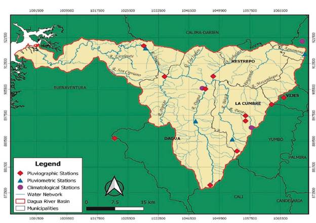
2.2 Climatic data
To obtain climate information, records of eighteen climatological, pluviometric, and pluviographic stations belonging to the Autonomous Regional Corporation of Valle del Cauca (CVC), available for the study area, were analyzed, of which five are conventional (daily records) and thirteen are automatic (logs every 10 minutes); the above for a period of five years (2015-2019). Thus, Figure 1 presents this area, as well as the location of the stations used in the research.
2.3 Soil information
Based on the review of the information provided by the CVC advanced geographic viewer for the year 2021 and the document called "semi-detailed soil survey scale 1: 25000 of the basins prioritized by the CVC" from 2014, it was possible to obtain the cartographic information and identify the main soil orders present in the study area, which belong to the Inceptisols, Entisols, Histosols, Alfisols, Mollisols, and Andisols. Likewise, the properties required for the study were: texture, organic matter, permeability, and structure.
2.4 The Digital Elevation Model (DEM)
For the elaboration of the slope map, a digital elevation model supplied by the CVC with a resolution of 30 m was taken as input, with radiometric correction, from which it was possible to obtain the slope map. It was worked on a file geodatabase using Magna Sirgas coordinate system for Colombia.
2.5 Cover layer and land use
These layers were provided by the CVC (2021), which presents updated information for 2018. A total of 94 types of coverage were identified. The main covers correspond to the dense mixed highland forest, cultivated pasture, and secondary or transition vegetation, while the main established agricultural crop is pineapple (Ananas comosus (L.) Merr).
2.6 Erosion models
2.6.1 Universal Soil Loss Equation-USLE: The empirical USLE model was used, which has been disseminated and used worldwide for more than four decades (Alewell et al., 2019).
This model allows for estimating the long-term average erosion, and it is found in function of six factors, as presented in Equation 1 (Wischmeier and Smith, 1978).
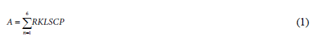
Where:
A is the soil loss calculated per unit area (t. ha. yr-1), which is the result of the product of the six factors, R is the erosivity of rain, a factor that reflects its aggressiveness and runoff (MJ mm ha-1 h-1 yr-1), K is the erodability, which represents the susceptibility to detachment of soil particles (t. ha. h. ha-1. MJ-1. mm-1), L is a slope length factor (dimensionless), S is slope steepness (dimensionless), C is a plant cover factor (unitless), and P is a management practice factor.
R factor
To determine the R factor, precipitation events with a record greater than or equal to 12.7 mm, and separated by at least six hours (erosive events) were analyzed. This factor was calculated with the methodology proposed in the USLE by Wischmeier and Smith (1978); However, taking into account that in this case, the records of the pluviographic band are not available, but rather the accumulated precipitation in 10 minutes, it was proposed to use this interval to determine the average precipitation intensity (IM) required in the calculation of the kinetic energy (e) for each mm of rain, based on Equation 2:

Once the total energy was obtained in each 10-minute interval, the value of e was multiplied by the total precipitation recorded in said interval (Eq. 3):

To obtain the total kinetic energy of the selected event (E), the energies obtained for each 10-minute interval were added and finally the equation used is the following:

Where EI30 is the erosivity of a single event (MJ mm ha-1 h-1), calculated as its total kinetic energy (E; MJ ha-1) multiplied by the maximum rainfall intensity in 30 min (I30; mm h-1). The R factor was determined from the sum of the erosivity of each of the events considered in the year and an average value of the years considered for each station was then generated.
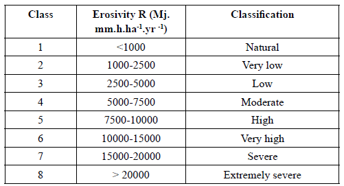
The R values obtained were classified according to the ranges proposed by Rivera and Gómez (1991).
K factor
The K factor was determined through the equation proposed by (Wischmeier and Smith, 1978) for soils containing less than 70% silt and very fine sand:

Where K is the erodibility of the soil (t ha h ha-1 MJ-1 mm-1), M refers to the particle size (based on the soil texture), a is the percentage of organic matter, b is the soil structure code, and c is the kind of permeability. For those cases in which the organic matter content was greater than 4%, this value was assumed.
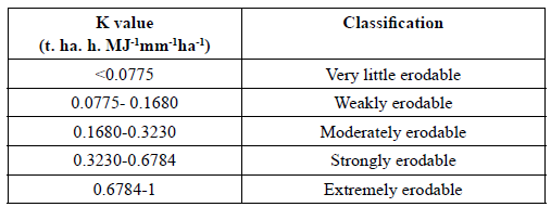
The K values obtained were classified according to the ranges proposed by USDA (1962).
LS factor
Given the rugged topography of the study area, in the case of factors L and S, the formula proposed by Pérez et al. (1995) was used:
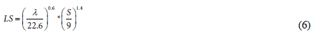
Where LS is the slope length factor (unitless), λ is the slope length (m), and s is the slope expressed as a percentage.
Factors C and P
Factor C was determined by taking into account the information on the coverage consulted in the CVC advanced geographic viewer (2021). In the case of the P factor, considering that currently there is no report on the management of the coverage or the conservation practices that are carried out, it was assumed with a value of 1 (dimensionless), with which the highest value of the loss is calculated.
2.6.2 Factor zoning using GIS
The zoning of the USLE factors was carried out using the QGis version 3.6 software. In the case of factors K and C, the shapes obtained were converted to raster format. For the R factor, an interpolation was carried out through the deterministic method of the inverse of the distance (IDW), taking into account that it is a simple algorithm that is designed to reduce the distortion of the interpolation of the determined surface (Riquelme et al., 2008), which is widely used in climate prediction and cartographic development (Núñez, 2014). Finally, the raster calculator was used to determine the LS factor and estimate soil losses due to erosion.
Results and discussion
3.1 Erosivity (R Factor)
The municipalities of Dagua, Restrepo, La Cumbre, and Vijes presented, according to the area, a rainfall erosivity mainly of a very low category (1000-2500 MJ.mm.ha-1yr-1) and low (2500-5000 MJ.mm.ha-1yr-1), while in Buenaventura there are mainly moderate and high categories, and sometimes even very high (5000-15000 MJ.mm.ha-1yr-1).
Of the eighteen stations evaluated, the two located in the municipality of Buenaventura presented high and very high values of pluvial erosivity (8753.76 MJ.mm.ha-1yr-1-10743.74 MJ.mm.ha-1yr-1), and the rest were among the categories very low, low and natural (636.68 MJ.mm.ha-1yr1- 4383.98 MJ.mm.ha-1yr-1).
Figure 2 presents the behavior of rain erosivity, which shows an increase in R values as it approaches the western flank (higher areas of the basin). This behavior can be attributed to the fact that the R factor decreases as the altitude changes from the mountainous areas to the lowlands. This coincides with that indicated by Guauque et al (2021), who found the lowest values of the R factor in the highest areas of the Combeima basin (Colombian Andes), due to the low amount of rainfall.
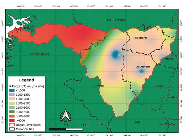
Likewise, Riquetti et al., (2020) modeled the R factor for South America, finding the lowest values of the R factor along the Andes Mountain Range due to the reduction in the amount of rainfall at the highest elevation, which shows that this factor can be influenced by the elevation of the mountainous regions on the continent.
There are no previous data reported for Valle del Cauca using this methodology. However, some investigations such as those carried out by (Ramírez et al., 2009) (Castro et al., 2017) in the departments of Caldas and Quindío, where the annual rainfall is between 1700 to 4000 mm, reporting erosivities classified as high and very high. On the other hand, a study carried out by Pacheco et al., (2019) for an Ecuadorian tropical region, indicated that the ranges of erosivity are between 3162.12 and 12683.72 MJ.mm.ha-1yr-1.
3.2 Erodability (K factor)
There are six main soil orders within the Dagua river basin, with K factors ranging from 0.143 to 0.842 t.ha.h. MJ-1mm-1ha-1, which falls into the weakly to extremely erodible categories. The order Inceptisol occupies the largest area with about 65.65% of the total land of the study area.
At the municipal level, the highest values are found in Buenaventura and correspond to the Inceptisol order, which reaches 0.842 t.ha.h.MJ-1mm-1ha-1. In second place, there is Dagua, with Inceptisols soils that reach values of up to 0.656 t.ha.h.MJ-1mm-1ha-1. In the case of Vijes and Yotoco, similar values are presented with maximums of 0.611 t.ha.h.MJ-1mm-1ha-1 belonging to the order of molisols, while, in Restrepo and La Cumbre, maximums of up to 0.559 were reported, in some Andisols.
Regarding the minimum value of erodibility (0.143 t.ha.h.MJ-1mm-1ha-1), this was the same for all municipalities. Figure 3 illustrates the K factor map in the study area.
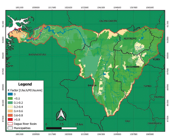
Of the entire basin area, 86.88% correspond to the categories of weak to moderately erodible, 10.84% are strongly erodible and only 1.40% are extremely erodible.
The soil with the highest K factor value is dominated by very fine sand with silt particles, permeability, and low organic matter content, and they do not present a good structure, making them more susceptible to erosion. While the lowest K values presented high content of clay and organic matter, better structure, and higher permeability.
Few investigations have been carried out on erodability in the Dagua river basin. In this regard, Alarcón and Reyes (2013), in studies carried out in the La Centella micro-basin, Dagua, values of 0.003254 t.ha.h.MJ-1mm-1ha-1 were found which are lower than those obtained in this research, taking into account that prior to the tests they supplied vermicompost, which modified the characteristics of the soil, due to the higher contents of organic matter, forming macroaggregates and improving the structure, increasing infiltration and reducing runoff, which influences the decrease in erodibility, despite this, it was highlighted that the erosion in the study area is high, especially considering the steep slopes and heavy rains.
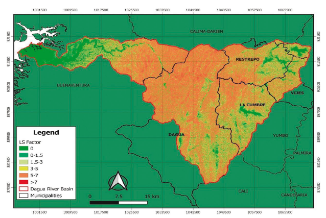
3.3 Topographic factor (LS)
The highest values of this factor (five to seven, and higher than seven), extend from the northwest to the southwest, mainly covering the municipality of Dagua, and are attributed to steep slopes (12-75%) and even higher than 75%, corresponding to steep slopes to steep slopes with great lengths, which corresponds to the highest slope classification categories for Colombia according to IGAC (2014). This factor leads to a very powerful rain flow rate and aggravates soil erosion. Figure 4 presents the map of the LS factor in the study area.
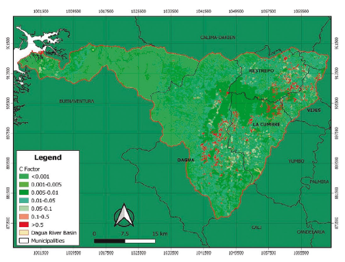
3.4 Coverages (Factor C)
It was found that the most representative covers are dense high-ground mixed forest and cultivated pastures, which represent 22.2% and 19.7% of the total area, respectively. However, about crops, the predominant one is pineapple, which covers 1.92% of the area, followed by coffee, banana, sugar cane, and tomato, crops that constitute 1.62% of the total area.
The factor C map is shown in Figure 5; the value ranges from 0.01 to 1.0. The highest C was assigned in the areas without vegetation cover and in the pineapple crop (1.0), taking into account that it is managed as a clean crop and that for at least one year, the fields do not have sufficient plant cover (Sughara, 2001), which can lead to serious erosion problems. The lowest C value corresponds to wooded areas (0.01), pastures (0.04), and crops with covers (0.18-0.5).
3.5 Estimation of soil losses in the Dagua river basin
In this regard, it was found that more than a fifth of the area of each of the municipalities of Dagua, Restrepo, La Cumbre, and Vijes, presents an erosion between 100-300 t ha-1 yr-1, where these percentages correspond to 21.22 %, 29.31%, 26.66%, and 25.93%, respectively. These values are framed within the categories of high and very high erosion, according to FAO-UNEP-UNESCO (1980). On the other hand, it was found that the factors that most influenced soil losses were LS and C. This is explained because they are the ones that determine to a greater extent the spatial variations of erosion rates within the same basin or region, where factor c is usually responsible to a large extent for soil losses, and LS is the most determining factor in the transport of the generated sediments (Coleman and Scatena, 1986).
Likewise, Dagua is the municipality with the largest surface area with very high erosion with values that are in the range of 300-500 t ha yr-1 and even higher. The soil loss map is presented in Figure 6.
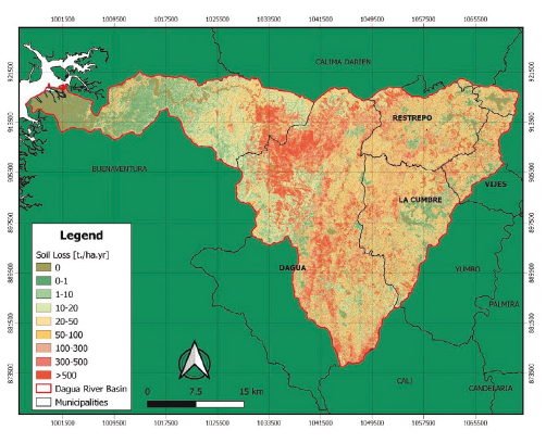
On the other hand, pineapple cultivation together with some areas of bare soil are the areas that contribute the most to soil loss due to erosion. In this way, 27.68% of bare soil and 69.24% of pineapple contribute to an erosion of more than 1000 t ha yr-1. Consequently, gullies have been evidenced in the Dagua river basin, which are located mainly on the border between the municipalities of Restrepo and La Cumbre (Rio Grande canyon).
In this regard, Rojas and Campo (2018) mention that erosion processes in this area are predominant, where the highest degrees of erosion are associated with the upper part of the basin, encompassing the municipalities of Dagua, Restrepo, La Cumbre, and Vijes.
4. Conclusions
More than 20% of each of the municipalities of Dagua, Restrepo, La Cumbre, and Vijes presented high and very high erosion categories. Despite the low contribution generated by the R and K factors to the water erosion of the basin, there was a strong influence by the LS factor as the most determining aspect in the transport of the generated sediments, since they are steep slopes, and factor C, which, given the scarce vegetation cover, is largely responsible for these losses.
On the other hand, areas with bare soils and crops such as pineapples contribute to erosion, sometimes exceeding 1000 t ha-1 year-1, an aspect that highlights the importance of plant cover in the prevention and control of water erosion.
It is important to promote soil conservation practices such as planting crops on contour lines, integrated crop cover management, land uses that integrate trees, eliminate inappropriate practices such as widespread burning and weeding, and in more critical cases considering processes of ecological restoration.

