


 Inglês (pdf)
 Artigo em XML
 Referências do artigo
 Enviar este artigo por email
 Citado por SciELO
  Citado por Google
  Similares em
SciELO
Similares em
SciELO  Similares em Google
 Permalink
1. Introduction
With law 1523 of 2012, the National Policy on Disaster Risk was adopted and the National Disaster Risk Management System for Colombia was established, and with decree 4147 of 2011, the National Unit for Risk Management (UNGRD for its acronym in Spanish) was started.
Additionally, the sub-directorate of Risk Knowledge is created, with a view to achieve several goals, such as promoting and strengthening the development of instruments for monitoring disaster risks through the various technical entities of the National System for the Prevention and Attention of Disasters (SNPD for its acronym in Spanish).
Similarly, the National Disaster Risk Management Plan for the period of 2015-2025, called "A Development Strategy", states the following motivation: "It is necessary to strengthen the surveillance and alert services that allow monitoring the behavior of seismic, volcanic and hydrometeorological phenomena, as well as to improve instrumentation and applied research processes.
The Colombian Geological Service, IDEAM (Colombian Institute of Hydrology, Meteorology and Environmental Studies) and DIMAR (General Maritime Directorate) must take the necessary measures to expand and consolidate existing monitoring networks, as well as to determine the needs for technological adaptation. Co-ordinated work with regional universities and research centers should be encouraged". The development of his work is consistent with the interests of good practices pursued by national policies that have been established to strengthen monitoring services for the prevention of disaster risks.
It can be pointed out that in the city of Manizales, the soils are monitored by applying the semaphore strategy based on relationships between rainfall and landslide events recorded in the Andes region (Figure 1). Currently, there is a meteorological network of stations that sends the information about precipitation, temperature, humidity and wind speed in real time.

This was an initiative of the Universidad Nacional de Colombia in Manizales, which found support in the Municipal Office of Prevention and Disaster Assistance (OMPAD for its acronym in Spanish), - it is currently called the Risk Management Unit (UGR for its acronym in Spanish), and since 2003, develops this proposal, - and which is currently expanding the number of meteorological stations.
In Manizales, soils are susceptible to surface landslides and are mostly triggered by rainy periods. Studies relate the events of landslides to rainfall, considering daily rainfall and rainfall record, which are triggers for landslides [1].
In Colombia, researchers have studied the annual rainfall regime and have increased the frequency of landslides by relating the bimodal curve of rainfall to the record of landslides, by searching for critical rainfall and cumulative rainfall thresholds with statistical techniques [2] [3][4].
Other works developed with hydrological models and slope stability propose a hydrological model known as Hyswasor with one-dimensional features by applying finite elements [6]. In the HidroSIGV.3 model, the proposal was to use geographic information systems [7], with the infinite slope model and the hydrological model, by taking into account soil properties, precipitation data, slope maps and estimation of soil depth with models [8] [9] [10].
According to Vasquez [11], he analyzed the hydrological response of slopes in a one-dimensional, two-dimensional and three-dimensional case, using the numerical solution of the Richards equation describing the flow in partially saturated media, In this work it is concluded that the one dimensional analysis can be applied to soils derived from volcanic ash and in the two dimensional case the obtained results are compatible with the limit equilibrium method.
Finally, Aristizabal, Martinez & Velez [12], having performed a review of the art on the study of mass movement triggered by rainfall in which they propose future guidelines: 1. Investigating the parameters for hydrological models in unsaturated soils, 2. Analyzing failure mechanisms to Coulomb model, 3. Incorporating rain transient data, such as duration and intensity in physical models, presenting shortcomings in the spatial resolution of rain, 4. using statistical and physical models for prediction of mass movements triggered by rains in an early warning system. It is clear the need to deepen in these research guidelines for the monitoring of landslides in real time.
This work is part of the fourth guideline mentioned above and of the work published by the author Peña-Rincón [13], with the purpose of contributing with a proposal to widen the monitoring of slope stability in rural areas with threat of surface landslides without the presence of ash triggered by the precipitation factor and affecting the community or infrastructure elements. Precipitation information can be obtained through meteorological stations near the study area that measures this variable in real time.
Precipitation information is obtained through meteorological stations near the study area measuring this variable in real time. The proposal is to take this information as an input element to evaluate the spatial and temporal dynamics of the saturation of the hillslope soil profile in its first 2 meters depth, a range in which it is considered a surface slide [14].
Physically based models use conservation laws and strongly depend on the parameters that characterize the system; these can be determined by field measurements or in the laboratory. These models allow to include triggering factors such as precipitation for the study of landslides, enabling forecasts about slope stability, through infinite slope stability analysis, which includes soil properties and the safety factor [15].
Richard's equation considers Darcy's law and the continuity equation to model the flow of water into unsaturated areas; however, there are modifications in the Richards equation, by means of the soil moisture capacity function, which permits to reduce Richard's equation in one dimension. Later, the profile of the hillslope was included by using Stefano and Evans functions [15][16][17] [18] to model the sub-surface flow that includes hillslope inclination for different scenarios under initial conditions of porosity, drainage and recharge. Finally, this equation 1 is known as hillslope-storage Boussinesq (HSB) [20]
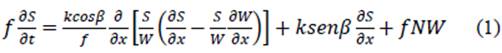
Being S the saturation variable, its parameters correspond to f the porosity, k the hydraulic conductivity, w width of the hillslope and N precipitation rate.
With the HSB equation, saturation is obtained along the profile, which is an input to calculate the stability of the hillslope through the safety factor (FS), and in turn, for the calculation of the stability of infinite slope with presence of water by infiltration.

Being C the cohesion, y unitary weight of the material, H the depth where the failure surface is located, β the slope of the terrain and ϕ' the internal friction angle [21][22].
However, the study of the effect of the topography on rainfall induced landslide on the hillslopes considers the curvature in the direction of the gradient (curvature profile) and the perpendicular direction for the gradient (contour).
Therefore, the profile of the curvature is considered to be associated to control the velocity changes of the mass flow in the slope and the contour or plane of curvature that defines the topographic convergence, which is associated to the important control over the concentration of the flow in the subsoil. The infinite slope model considers the flow of groundwater parallel to the surface. The safety factor is expressed under these hypotheses [23] [24].

Where D is the depth to the cut surface and γ m, γ s and γ b are the humidity, saturation and buoyant density, respectively; h(x) is the phreatic level.
[Fan (1998)] proposes the underground storage capacity variable Sc(x,t)=fW(x)D(x) where W(x) is the width function of the hillslope, D(x) is the depth of soil and f is the porosity of the soil as indicated in (Figure 2). Then Talebi, Troch & Uijlenhoet [25] [26], propose the expression for the safety factor which considers the following normalization σ(x)=S(x,t)/Sc(x,t), for soil depth and the constant angle along with Equation 2, it is obtained:
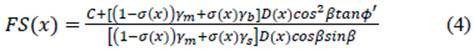
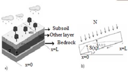
Figure 2 a) A three-dimensional view of the hill, b) a profile of the hill showing the saturation variable S(x) and the precipitation (N). Figure (b) is taken from [6].
Equation 4 allows to have information about the stability of the slope along the profile of the hillslope as a function of saturation as a function of precipitation.
2. Materials and methods
This proposal is to strengthen the knowledge of the risk by means of a monitoring tool, using the precipitation information available of a meteorological station that is integrated to the system of early warning for landslides in Manizales and administered by the Institute of Environmental Affairs of the Universidad Nacional de Colombia. Our interest focuses on soils without presence of volcanic ash in rural areas with high hazard.
The proposal contains a methodology (Figure 3), which integrates the real time measurement of the precipitation by the meteorological station and is incorporated into the HSB equation, together with the theoretical data of porosity, conductivity and those calculated as the width of the hillslope, the angle and the information about the profile of the hillslope to monitor the saturation on the slope and finally to submit the information regarding stability through the safety factor.
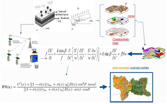
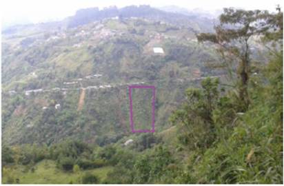
As an application of the proposal, information from the thematic map of high threat for landslide of the city of Manizales was taken, by digitizing the area to select the hillslope (annex 1). A trip was made to the village of Balastera in the city of Manizales where it is clear the need to conduct monitoring in areas with presence of rural settlement (Figure 9), identifying the hillslope with the condition of absence of ash layers as verified by the soil maps (annex 3) and the geology map (annex 5). Then, theoretical data of porosity, hydraulic conductivity and soil depth profile were proposed, making thematic maps for each of the geotechnical properties of the area; this information is transferred to Equation 1, which processes and delivers the saturation along the profile of the hillslope in a period T, and finally, the safety factor is calculated with equation 4. Then, the profiles of the hillslope study area were characterized (Figure 4,5).
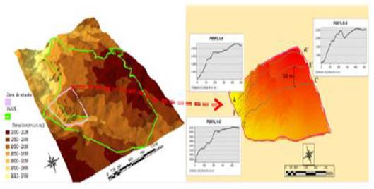
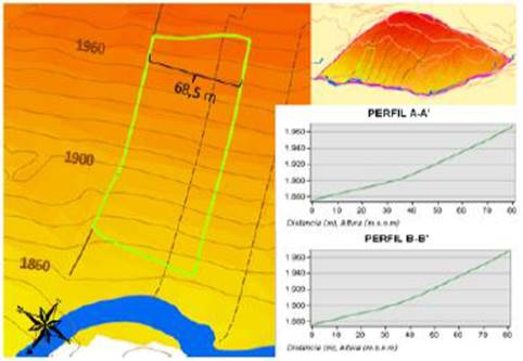
Figure 5 The study area is located in the rural part of Manizales, known as Balastera; the hillslope that was monitored is demarcated.
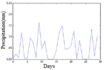
Finally, the width and profile of the hillslope are shown in Figure 6. The hydraulic conductivity was obtained by the program Soil Water Atmosphere Plant (swap); the geological map and soils are digitized from the information of the land ordinance plan of Manizales. The precipitation data of the EMAS station is shown below (figure 6), which is located near the selected hillslope (this station sends data on temperature, relative humidity, evapotranspiration and precipitation every 5 minutes). The data were provided by the Institute of Environmental Affairs (IDEA) of Manizales, in collaboration with this work.
3. Results and Analysis
The slope parameters are presented such as the constant width of 68.5 m, with an average inclination of β=53°. Due to lack of information of the other parameters, theoretical data are assumed regarding intrinsic angle β/ϕ=0.77, effective cohesion of 7 kN m-2, porosity f = 0.3, and hydraulic conductivity k = 0.06 mh1.
The information of precipitation was taken from the month of November 2012 with an initial condition of 10% of Sc(x), border condition S(x=0, t)=0 and x= + US = 0,
with
+ US = 0,
with
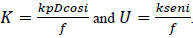
Figure 7 presents the result of equation 1, using finite differences in the Python environment. It was calculated for the following days of precipitation T 1= 5th day, T 2= 10th day, T 3= 17th day, T 4= 27th day. Theoretical values of depth D are assumed, varying between 0.2 m in the lower part of the hillslope and 2 m in the upper part.
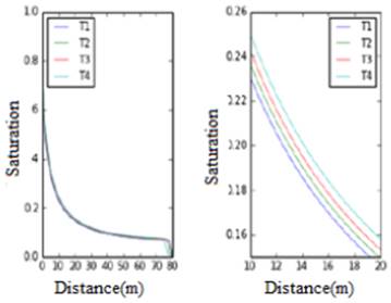
Figure 7 Response to the saturation of a hillslope, for 5 continuous T periods of precipitation, being L=80m.
Theoretical data were considered for y m = 1000 kg m-3, y s =1600 kg m-3 and γ b = 600 kg m-3 [25], for the specific weight of water, saturation and buoyant. For this scenario, it was stable along the profile of the hillslope for the different days.
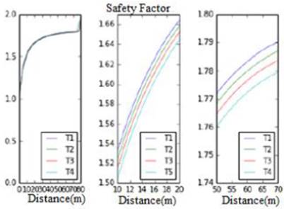
By varying the theoretical depth value at D=1 m for the same study area and with the same geotechnical parameters, the following safety factor results were obtained, indicating that the hillslope is stable along the profile.
In these scenarios, it is viable to know the stability along the profile of the selected hillslope, thus allowing to have important and truthful information, but conditioned to the knowledge of the measurements of the geotechnical parameters, thus generating information towards the early warning system to be administered in real time.
4. Conclusions
A methodology is proposed to expand the use of meteorological data provided by a meteorological station located in rural areas threatened by landslides with absence of ash layers, and with the presence of a human settlement as is the case of the Balastera area in Manizales Colombia.
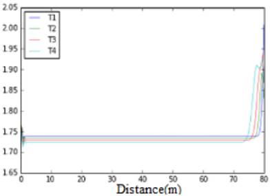
In the scenarios, between theoretical data and measured data, the safety factor was obtained where, for each day, the curves manage to report stability along the slope profile(see Figure 8, [10); this allows to report the evolution of stability with respect to the detonating factor of precipitation, however it depends strongly on the calibration of the hydrological parameters.
Therefore, this proposal contributes to the monitoring of stability, by calculating the saturation of the surface soil in real time according to the precipitation reported in the hillslope.
This methodology can be integrated into an early warning monitoring system; however, it relies heavily on measurements of the hydrological parameters and the calibration in the initial saturation condition of the physically based HSB model.
Thus, this work motivates the use of data measured by the meteorological stations to strengthen the monitoring of hillslopes and of the slope stability in rural areas and in a future work other to areas of higher hazard.

