English (pdf)
 Article in xml format
 Article references
 Send this article by e-mail
 Cited by SciELO
  Cited by Google
  Similars in
SciELO
Similars in
SciELO  Similars in Google
 Permalink
Introduction
"Nobody lives everywhere, everybody lives somewhere" (Haraway, 2016: 31).
Humans are surrounded by and made up through other beings: plants, animals, fungi, and microscopic viruses and bacteria. All these denizens carry histories of encounters, mutual contamination between species that can be narrated and visualized (Tsing, 2015). This ecological web of life has moved into the anthropocene, a historical epoch where human influence on our nonhuman surroundings has increased thoroughly if not critically (Moore, 2015). In this context, multispecies encounters are rapidly converting into losses and extinctions. Whole ecosystems are threatened by disappearance in what is being called the "sixth mass extinction" (Pievani, 2014). Ongoing habitat loss, fragmentation resulting from deforestation, pollution, and unsustainable land use have drastically altered the ecology of the world to an alarming state (Maron, Simmonds & Watson, 2018; WWF, 2018).
To raise public awareness and increase understanding of the ecological crisis we are living in, it is of utmost importance to imagine and develop effective environmental communication strategies (Schwarze, 2007; Okaka, 2016). More specifically, environmental communication needs to focus on reaching a broader audience. It is important to shift strategies to change behaviours that are contributing to the degradation of certain ecological systems with compelling visual media playing a key role (De Young, 2000). Besides top-down interventions, a strong bottom-up movement and collective understanding are necessary to engage with environmental issues in an inclusive and intersectional manner. Then, not only will widely visible environmental issues be addressed, but underlying structures and social processes will also be engaged (Bennet et al., 2017).
As an approach to environmental communication, this paper proposes Ecopolitical Mapping as a way to creatively communicate environmental issues and challenges in more productive ways. Ecopolitical Mapping is a novel creative research methodology, which uses collective mapping to understand power relations between humans and nonhumans. Using a multispecies approach to our mapping, we understand non-humans beings as equally important terrestrial and social co-inhabitants, rather than as mere resources for the development of human activities (van Dooren, Kirksey & Munster, 2016). Through drawing on maps, culturally constructed perceptions and experiences are captured and can be used as a starting point for conversation and discussion (Ares & Risler, 2016). Rather than distance our own methodology proposal from the traditional collective mapping, we consider it as a continuation, a way of furthering these methodologies and open new explorations in fields such as political ecology and multispecies studies.
The methodology of Ecopolitical Mapping has so far been implemented in three separate projects. The collection of projects is diverse in their geographical extensions and cultural backgrounds: Cartografías de las costas del Biobío (South Chile), Multispecies Resistance: A Cartography of Love and Disaster (Europe), and Wildnisstadt Berlin (Germany). The final products reflect tensions between thriving and threatened ecologies. They serve as communication tools and trigger discussions about the contrast between human impact in different regions in the world and opportunities for nature conservation. This research document reflects on three applications of our Ecopolitical Mapping method and offers guidance for future iterations of this methodological approach.
Context: Three ecopolitical mapping cases
Previous collective mapping projects have mainly centered around urban planning (Safiullin et al., 2015) and conservation management (Casti, 2014). These projects often adopt an utilitarian point of view in regards to other-than-humans. Historically, western society has comprehended other species as objects, to the point of considering them mere landscape elements, passive and not reactive agents (Latour, 2018). Following indigenous traditions, and a sentient ecology conceptual framework, we understand multispecies relations as social relations (Anderson, 2000). Birds, insects, and rivers stop being perceived as objects and are converted into social beings: from objects to subjects, from landscapes to encounters (Tsing, 2015). Ecopolitical Mapping is, then, a methodology that enables the translation of those stories into images, as a way to briefly visualize the infinite encounters happening everywhere on this planet.
The methodological adaptation of collective mapping was first developed and applied in Chile. During 2017, in the city of Concepción, an interdisciplinary group of activists came together to use social cartography to communicate environmental issues happening in their dwelling places. Their intentions focused specifically on mapping biodiversity and human impacts in the Biobio Region near the city of Concepción. After conducting several mapping sessions, they collaborated with artists to transform the mapping sessions into an illustrative map. This interpretive map was later used as an environmental educational tool for NGOs and in High Schools in the region.
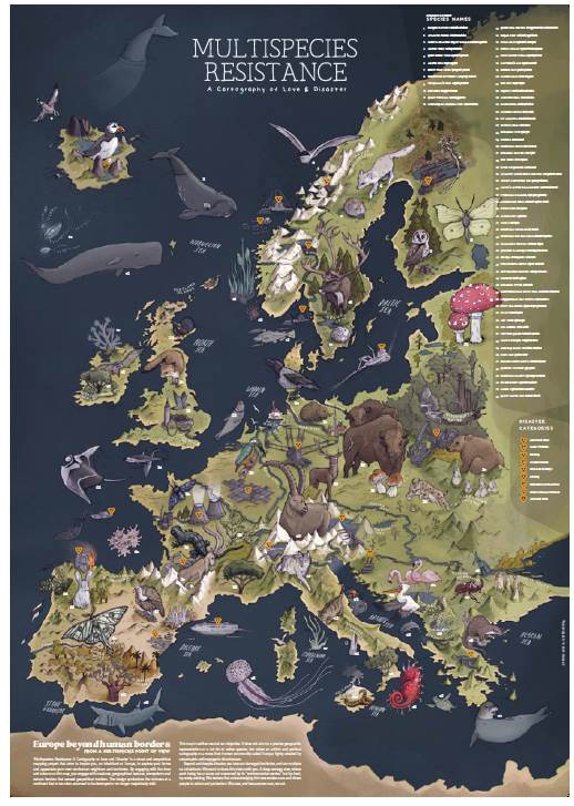
Two years later, we decided to build on these experiences and use similar concepts and methods in Europe. Inspired by love and care for non-humans dwelling in Europe, we began the process to create an illustrative map for broader environmental education at a larger scale. This is how Multispecies Resistance: A Cartography of Love and Disaster was born; a mapping project which aims to raise awareness about the diversity of non-human inhabitants living in Europe. While the general approach is similar to the Biobio case, the European project is novel in regards to the diversity of participants involved and the continental scale of the map.
Shortly after finishing the Multispecies Resistance mapping process, we decided to apply our method to a more specific location, reducing the scale and focusing on urban settlement multispecies interactions. This is how the Berlin Wildnisstadt mapping project began; which aims to unfold the rich biodiversity of Germany's capital city. Simultaneously, the project joins forces with the Berlin National Park City campaign, as a way to communicate the importance of recognizing the existence of non-human neighbours in the city (Wildnisstadt Berlin, 2021).
Methodology: Ecopolitical mapping as a tool for environmental communication
The methodology of Ecopolitical Mapping is divided into four stages: (1) mapping sessions, (2) data analysis, (3) map creation and (4) environmental communication. While the stages can be approached as separate activities, they are interlinked as the activities build upon each other and develop through the process of communication and mapping. In what follows, we will offer an outline of the four stages.
1. Mapping Sessions
Gathered around a canvas, in which only the main geographical features of the area to be mapped are shown to provide geographical context -but is otherwise blank-, a group of participants and informants is asked to draw eco-political relations and processes on the map (Robbins, 2011). Mapping sessions can be organized in person, by physically gathering people around a table, or online, with cooperative tools such as Mural (www.mural.co).
Participants are guided in the mapping process, by asking them to draw geographical structures such as rivers, lakes, mountains and coasts. They are also asked to draw non-humans inhabitants such as charismatic, endangered or endemic species.
Finally, they are asked to mark the positive and negative anthropic influences on the environment.
Depending on the size of the mapped area and the number of key informants which need to be engaged, a number of workshop sessions can be organized. Online workshops are particularly suitable when larger areas need to be mapped, as they allow collaboration across nations and geographical barriers to in-person meetings.
2. Data Analysis
After concluding the mapping workshops, the collected data needs to be further analyzed by the leading team. As a first step, the maps are collated into one new map which merges all existing information. In parallel, the accuracy of collected information can be assessed. For this step, external experts can be involved, which could check and assess whether the representation was geographically accurate, and the represented species and processes correctly named and represented. At this stage, the aim is to find a balance between scientific narratives and participants' stories, perceptions and traditional ecological knowledge (Huntington, 1998).
3. Map creation
During map creation, collaboration with an illustrator becomes key. The raw map becomes a collated map, which is used as a basis for what will become the final illustrated map. Given that Ecopolitical Mapping has mainly an environmental communication scope, in this stage a compromise between map accuracy and graphical representation needs to be made, with a bigger focus on the latter. It also becomes necessary to further reduce the mapped elements, to ensure that the final drawn map is easily readable and graphically appealing.
4. Environmental communication
Environmental communication occurs throughout the whole process. During Ecopolitical Mapping, a social space is created where people can think and learn jointly to capture the complexity of a problem. Through participation people with diverse backgrounds, i.e. citizens, activists, artists and scientists, come together and exchange their situated knowledge (Krueger et al., 2016; Pohl, 2011; Hedesan & Tendler, 2017). In doing so, the social learning practice enables co-producing knowledge, involving moments of emerging values, which strive for a more complex picture when tackling prevailing value-laden problems such as biodiversity loss (Sharman & Mlambo, 2012; Stengers, 2018). The interim results are presented through digital articles and at conferences and workshops, in order to share with a broader audience about the Ecopolitical Mapping process and engage new participants in further workshops. Finally, the illustrated map serves by itself as a communication tool, and can be further used in environmental communication efforts such as for activities in schools, festivals, or workshops.
Case studies
We now present three case studies where the Ecopolitical Mapping method has been implemented. The scales, numbers of sessions and number of participants involved in each case are different, but all of the cases follow the previously proposed stages to fulfil the project's aims. Our main focus relies on the Multispecies Resistance experience, because we had the opportunity to thoroughly document the whole process and critically reflect on our own methodologies.
Case Study 1: Cartografía de las costas del Biobío
Ecopolitical Mapping was first coined in South Chile by a transdisciplinary team of activists, including some of the authors of this article. The methodology was intended to be an instrument of an environmental communication project to raise awareness of the degradation of local ecosystems in the Biobío region. This area lies within a conservation hotspot, and nevertheless is labeled as a sacrifice zone because of its deeply degraded natural environment (Bullard, 2011).
The transdisciplinary group of activists, composed of scientists, artists and environmental educators, came together to make a tool for environmental education and communication of the human threats and for addressing the shifting inequalities between humans and other species. Through the blending of an ecopolitical lens and a multispecies perspective, the team aimed to unveil the complexity and multiplicity of social interactions beyond human societies. Ecopolitical Mapping was born to extend the cartography process to the more-than-human world (Abram, 1996). Through a multispecies approach, the more-than-human relationships within the region can be mapped, allowing to display the multitude of organisms, their entangled relationships, and how they shape the territory (Kirkse and Helmreich, 2010).
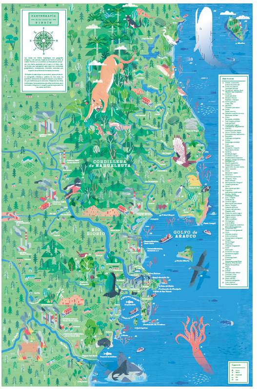
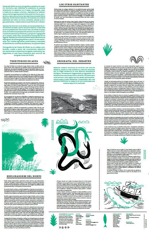
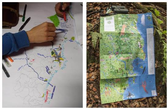
The team conducted two sessions, with local environmental activists, outdoors enthusiasts, and young naturalists, who talked about threatened native species, charismatic species and their symbolic importance for locals (Fig. 1a). They discussed the traditional names of general geographical features: toponymies for hills, bays, lakes and beaches. They also collected folklore stories during the sessions, related to human and other beings' encounters (Fig. 2a). The surface of the mapped area was approximately 24,000 km2. After this, the resulting maps were collated into a draft map by the team, which was used by artist Cristian Toro (www.estudiotoro.cl), to create a final illustration showing the political ecology of the Biobío coastal area (Fig. 1b). Hence the name: Cartography of Biobío's Coast (see Appendix for final illustration).
Courtesy of Bastian Gygli.
FIGURE 1 a) Collective mapping process (2018), courtesy of Jens Benöhr. b) Final printed map version of the Biobio project (2018)
Courtesy of Bastian Gygli.
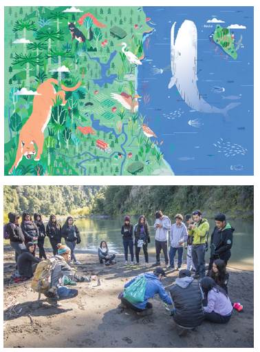
FIGURE 2 a) Details of the final illustrated map by Cristian Toro, showing I geographical and multispecies features of the Biobio Coast. See Appendix for final illustration. b) Environmental education workshop in Alto Biobio, conducted by the Ecopolitical Mapping team (2018)
The innovation in this approach was the politically situated composition of a map, to trace and visualize not only the marvelous biodiversity that surrounds us, but the power structures underlying the relationship between humans and other earthly denizens. Thus, fauna, flora, funga, bacteria, viruses, and even whole ecosystems like rivers, forests and mountains pass from objects to subjects. This perspective is also called "sentient ecology". This idea extends the concept of personhood to animals, and ultimately to all ecological life (Anderson, 2000). And so, the idea of the "other" (previously assigned to non- Westerners) is relocated to the non-human. This approach explores this new otherness and its long history of co-domestications, alliances and murders across landscapes and more-than-human territories.
This was an intentionally biased research in which the team used mapping as an act of radical care. By recognizing the intimate relationships of care for nonhuman beings, the participants began to "manifest new ways of knowing [nonhuman] species - outside of and beyond logics of commodification, instrumentalization, exploitation, and eradication" (Gillespie & Narayanan, 2020). As such, they reconfigured the kinds of knowledge about this particular territory through a local perspective of care, in both the visual mapping process and the final outcome. With this intention, the illustrated map was then used in environmental education workshops in the Biobio Region (Fig. 2b).
At this point, participants continued exploring the incidence of the application of the cartographic image as a tool for ecopolitical subjectivation. Those who initially participated in the activity could share certain territorial, experiential and technical notions from their own disciplines. The development of a graphic piece allowed them to transform stories of encounters into graphic images on a map. From this cartographic reading, the group dialogue process was translated into an information design, where certain elements that determine the morphology of the territory are highlighted in contrast to the impact of the local extractivist industry. Thus, the map was not offered as the sum of coordinates or landmarks, but as layers that can be worked on graphically in order to facilitate the interpretation of the information and make it more attractive.
Case Study 2: Multispecies Resistance
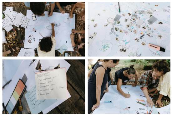
For the Multispecies Resistance project, the leading research team conducted the Ecopolitical Mapping process through a number of activities. Three collective mapping workshops were organized: two in-presence at the Prinzessinengárten in Berlin (Fig. 3) on 20-nst ofAugust 2021, and one conducted online on the 15th of September of the same year (Fig. 4).
Courtesy of Multispecies Resistance.
FIGURE 3 Impressions from the Berlin Ecopolitical Mapping workshop (2020)
Courtesy of Multispecies Resistance.
FIGURE 4 Impressions from the online Ecopolitical Mapping workshop (2020)
In these collective mapping workshops, the leading team gathered together a group of key informants such as activists, scientists, students and other nature enthusiasts. Then, they asked the participants to draw their perceptions about nature, and the interplay between human and nature on a map of Europe. The map was prepared on the software ArcGIS, illustrating the main geographical features of the continent, but otherwise offering a blank canvas for the collective mapping process (Fig. 5a). For the in-presence workshops, the map was printed on a A0-size sheet, and layed out on a table, around which the participants gathered to draw. A total of 10 to 15 participants were invited to the presence workshops, and divided in two groups, gathering around two tables and standing. After an initial introduction, the team invited the participants to introduce themselves, and to draw their home ecosystem and their favourite species on the map. These introductory questions allowed them to familiarize themselves with the procedure. Afterwards, participants were instructed to draw directly on the map. Acting as facilitators of the workshops, the leading team used questions on biodiversity, geography and human impact to drive the mapping procedure, and welcomed the participants to share the stories of the items they were drawing on the map. This was done to facilitate knowledge exchange and start discussions around nature and its state in Europe, as well as the interplay between humans and its non-human neighbors. The mapping session lasted an hour, with a short break in between. The session concluded by sharing the results, and having a group discussion around the final drawn maps.
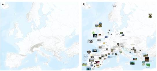
A total of 36 participants joined the Ecopolitical Mapping workshops. The backgrounds of the participants varied, ranging from ecology to arts and design. Participants were students, NGO workers and researchers. A total of 7 maps were drawn, which were then collated into one final map. An extract of it can be seen in Fig. 4.
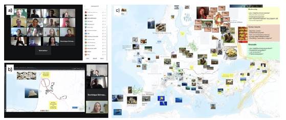
The online workshop had a similar structure. The participants gathered on the video-communication platform Zoom (www.zoom.us). After a brief introduction, participants were divided into three smaller groups in breakout rooms, accompanied by one facilitator each. The team used the tool MURAL (www.mural.co) for the mapping session. The tool allows the setting of a canvas, on which the map of Europe was overlaid. The participants could then write and add images from a browser or an iOS based device through the use of an app. Additionally, the team developed a GIS web-based platform on the ArcGIS StoryMap tool (https://storymaps.arcgis.com/) to allow web users that could not attend the workshops to input further information on a map (Fig. 6). This allowed the team to gather further perceptions from a larger number of participants and from regions of Europe from which we had little information about.
The resulting maps from the workshops were collated into one final map, which will then form the basis for the final illustration. The team systemized the spatial and graphical data from the maps through a group activity. Using the Mural application, the team went through each region of the map, and using an iterative process, collated the information from all the maps. This step was carried out by looking into patterns in the maps, and selecting first common items (ecosystem, species, and pressure) from the different maps, which were regarded as most important. In parallel, the information was fact-checked and its correct spatial representation ensured.
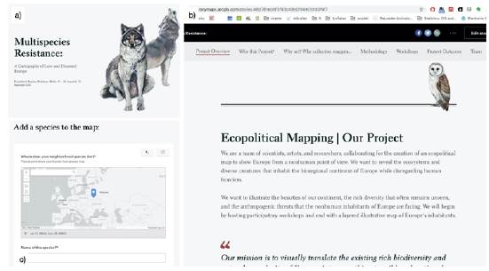
Parallel to the mapping process, three digital stories were created on the ArcGIS StoryMaps platform to inform the broader public about the project and illustrate the process and methodologies used. ArcGIS StoryMaps is a web-based platform that allows authors to combine maps, multimedia, and narrative text in a simple platform. It allows readers to interact with content through immersive reading experiences. It's also easy to get started with and assemble content. As such, it was a suitable platform for the project's communication objectives.
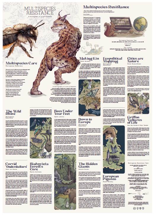
The digital stories grew together with the development of the project, and were used as a communication tool. A total of three stories were created. In the first, the project and team were presented. The second one shows the results of the Berlin Workshops. The third one shows the results of the online mapping session, and also works as a platform to collect further species stories. The illustrator Antonia Lara (www.antonialarag.com) was involved throughout the entire development of the project. This is important, since the interplay between her creative illustrative process and the mapping process was needed for the final map to be drawn. Some examples of selected preliminary illustrations for the map can be seen in Fig. 7.
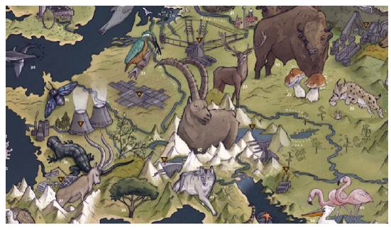
FIGURE 7 Details of the final illustrated map by Antonia Lara G, showing geographical and multispecies features of Europe. See Appendix for final illustration.
Based on the resulting map from the data analysis stage, and in collaboration with Antonia Lara, the team merged the mapping results into a collectively designed map that addresses Europe as a continent inhabited by many other species, which we addressed as "co-inhabitants" or "our neighbours". More than a human-centric map, the goal was to create an eco-centric map, which presents the contrast between the human impact in different regions of Europe.
Through a participatory process, the project unpacked the existence of European geographic features like rivers, mountains and valleys, with a focus on endemic species living in ecosystems that are not bound by human-political borders. Utilizing collective mapping, where groups of key informants were gathered together to analyse certain territories and their characteristics, the project was a joint scientific work bringing together scientific expertise and the use of visual design platforms.
A big challenge encountered here by the leading team, compared to the Biobio map, was the vast spatial surface that the Europe map was hoping to cover. During the mapping sessions in Berlin, participants were mostly of German nationality, which presented a difficulty when trying to map Western Europe and East Europe (Central Europe did not present difficulties for the participants). Nevertheless, participants from western and eastern European countries came to the online workshop, so the team was able to map more of the ecology of those Regions.
During the mapping session it became clear that Europe's surface is too big for people to imagine and map. The team also learned that each person mapped with more precision and enthusiasm their own local region, or field of knowledge. This may indicate that people's perception of a territory has a scale limit. That threshold may be interesting to explore: is it an emotional threshold related to people's experience localized in a certain territory, or is it just a size threshold where we cannot perceive/remember properly beyond a certain surface limit?
Overall, the results that each map offers is a socially constructed perception of Europe, based on the participants gender, age and cultural background. Participants tend to recognize that Europe in general is an environmentally degraded continent, but at the same time most of them were keen to highlight the conservation of certain areas or ongoing restoration projects. Interestingly, participants felt more related to a type of conservation with aims for the coexistence with other species, more than fortress conservation proposals.
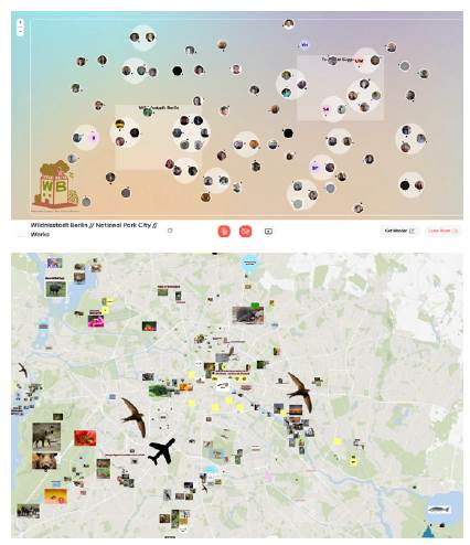
Case study 3: Wildnisstadt Berlin
Cities are valuable ecosystems and crucial social, creative spaces, whereas at the same time cities are hotspots of socio-ecological challenges often leading to neglecting the crucial role of urban nature. That is why a team of citizens, artists and scientists came together within the project Wildnisstadt Berlin aiming for the disclosure of Berlin's urban nature, involving humans and non-human beings alike, and raising awareness for Berlin's existing and potential biodiversity.
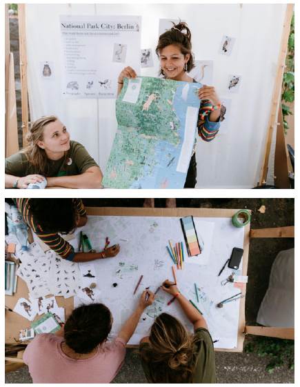
After the Multispecies Resistance mapping session in Berlin, a few of the local participants proposed to apply the same methodology to the urban environment and scale of Berlin in order to bring in this type of environmental communication into the city. In the following weeks, a leading team, composed by Humboldt University, Free University of Berlin and Multispecies Resistance members, adapted the methodology to adjust to the scale of Berlin and apply for an event spot at the Mitwelt Festival hosted by the "Freizeit- und Erholungszentrum Berlin" (FEZ). With the support of FEZ, they printed Ao size maps of Berlin at various scales to test out the amount of detail needed to engage with participants. On September 2020, the team conducted two mapping sessions at an outdoor stand with the printed maps and our Multispecies Resistance illustrations to set the visual context (Fig. 8). These sessions focused on two sets of questions. The first set focused on the Ecopolitical Mapping themes used in the previous Multispecies Resistance sessions using a multispecies approach. The second set focused on envisioning Berlin's future by asking 'What if Berlin was a National Park City?'.
Courtesy of Multispecies Resistance.
FIGURE 8 Members of the Wildnisstadt Berlin team explaining the project ' and mapping with a general audience (2020)
These sessions sparked a collaboration between the research team and the emerging social movement Wildnisstadt Berlin to advocate for the National Park City campaign in Berlin. Together they hosted an online event to engage in a dialogue forum and a collective mapping session. This digital event allowed the gathering of approximately 100 participants in total, with over 50 people partaking in Ecopolitical Mapping sessions. Break out rooms were hosted in English and in German in order to engage both international and local residents. A total of four maps were produced during these first sessions that are to be used to carry the project further in other events. The mapping sessions concluded with a discussion about the role of nature in the city of Berlin and questions of how to foster awareness for nature in urban spaces (Fig. 9).
Courtesy of Multispecies Resistance.
FIGURE 9 Results ofthe Wildnisstadt Berlin mapping sessions (2021)
At the time of this publication the Berlin mapping sessions are still ongoing. The method has been applied in the framework of academic events (Freie Universitát Berlin) and non-academic events (e.g. Wilde Möhre Festival) bringing together people with diverse knowledge. This particular case shows also how mapping sessions grow through networking and local enthusiasm and convert into new projects and mapping events, showing that the method itselfhas been able to engage citizens and scholars into environmental communication activities. The research team has also come to realise that the ecopolitical mapping methodology is more suited to raise questions about people's immediate surroundings and how they relate more closely to them in their everyday life in smaller scales, like cities, than at larger scales, such as the continental scale (Europe).
Conclusion: We care, we act!
This research document offers a novel methodological approach to multispecies research for environmental communication. Moving beyond human-centered mapping, Ecopolitical Mapping is offered as a way to creatively and collectively communicate environmental issues while considering more-than-humans beings as our terrestrial, social, and political co-inhabitants. Especially present socio-ecological problems are complex, uncertain, involve high stakes and demand urgent decisions (Hulme, 2009). Ecopolitical Mapping can serve as a tool that improves capturing these urgent ecological problems by providing a voice to the species and places that cannot defend themselves from environmental disaster or destruction.
In order to illustrate how this methodological approach unfolds, we have offered three different case studies and reflected on our experience as researchers and participants. The aim of the three different projects here studied was to raise awareness about nature conservation, and communicate how certain ecosystems are in need of critical protection. This approach to science communication, which brings conservation biology closer to a general audience, aims to develop a sense of wonder and attachment to local biodiversity. The final illustrated maps are and will be the result of a collaboration between scientists, specialists, artists, and passionate ecological protectors to reveal the rich biodiversity landscapes in a unique and localized process. Thus, a map is not only made up of coordinates or landmarks, but of reading layers that can be worked on graphically in order to facilitate the interpretation of the information and make it more attractive.
The increasing complexities brought about by the global ecological crises are calling for us to actively disrupt and challenge the conceptual frameworks currently dominating the way we research and communicate (Sterback, 2014). Creative processes are nuanced and dynamic, and may be an interesting alternative to disrupt research methods. In this case, it's important to characterize assets in the creative research, the actions performed, as a way to gain insight about building better methods and understanding of possible outcomes. By first better understanding creative research possibilities, we can improve the design of communication projects that impact people's behaviour related to the ecological crisis (Linder, 2016). We believe this methodology would work in interesting ways to assess people's perception of nature conservation areas, or the participatory planning of a landscape (Nygren & Rikoon, 2008).
The innovation in this approach was situating humans and other non-humans on the same social grid, and through participatory mapping, together with the participants we visualized the loss and extinction of species as eco-genocides. We also pointed out the specific discrimination against non-human beings and our ecosystems through texts and images. In this context, being part of a community can no longer be thought or felt as a community composed of only human beings. Being-in-common becomes a process of belonging to a community of multiple species including all those with whom we weave life on this strange and lively planet (Gibson-Graham & Miller, 2015).
This was a politically situated research and creative project. Through this process, the team wanted to show that we are not neutral, neither objective. Our research team cares. And because we care, we act. We hope that this paper contributes to reflect on how to land on coexistence coordinates and thus achieve an understanding of the affections, cares and pains that abound in the relationships between companion species.