


 English (pdf)
 Article in xml format
 Article references
 Send this article by e-mail
 Cited by SciELO
  Cited by Google
  Similars in
SciELO
Similars in
SciELO  Similars in Google
 Permalink
INTRODUCTION
There are several incompatibilities between environmental offerings and areas used for agricultural activities since, in many cases, these activities are carried out in areas that experience major climatic threats, such as water deficiencies or excess water in the soil, frosts, and floods, among others (Brown and Raymond, 2014; Kim and Arnbold, 2018). Likewise, the socioeconomic development of communities or producers located in threatened areas suffers high vulnerability, generating inequity in the distribution of resources (Magrin, 2015; Cleves-Leguízamo et al., 2017).
The municipality of Uribia in the Department of La Guajira has a desert climate, with annual precipitation averages between 300 and 600 mm and an evapotranspiration of 2,000 mm, which constantly generates water deficit conditions throughout the region (Corpoica, 2016). This situation puts at least 105,000 people of the indigenous Wayúu population who depend mainly on goat production systems at risk.
Rudimentary agricultural practices result in high vulnerability to seasonal rainfall variability and extreme weather events. The third national agricultural census (CNA) for year 2013 recorded 173,134 sheep (mostly Ovies aries "camuro" breed) and 243,351 goats (mostly Capra aegagrus hircus "guajira" or "criolla" breed) for this municipality, a ratio of 1:1.4 (DANE, 2014), associated with regular land use patterns such as transhumance. The main sources of animal feed are pastures and shrubs, so the mobility and diet of the animals depend on the scarce distribution and variability of plant species (Steinfeld et al., 1996; Shinde et al., 1998; Oba et al., 2000).
Agroclimatic-zoning studies contribute to agricultural system adaptation since they provide information for the planning of agricultural activities and establish incompatible uses that negatively affect sustainability and competitiveness (Gelcer et al., 2018). Furthermore, they incorporate climatic and agroclimatic indicators that are useful for identifying potential areas in the establishment of production systems and contribute to the generation of strategies for climate change and variability prevention and adaptation (Basualdo et al., 2015).
Zoning based on the climatic variables of solar radiation, temperature, and precipitation (Arce and Uribe, 2015), as well as the evapotranspiration of the reference crop (ET0) (Allen et al., 1998), are determining factors in the behavior analysis of plants or agricultural crops of interest with climatic variability events and in the study of adaptation mechanisms for food production. Average values of these elements have been used in countless zoning studies for multiple crops, usually based on methodologies such as agro-ecological zoning or AEZ (FAO, 1996; Fischer and Velthuizen, 2002).
Some agroclimatic zoning analyses include factors such as thermal supply and water availability on daily or decadal scales and specific aspects of crop physiology and edaphoclimatic requirements (Brunini et al., 2001). Others incorporate thematic layers that characterize the territory, such as land cover, obtained primarily from the performance of land resource inventories (FAO, 1996). Moreover, many studies have adopted methods for analyzing suitability through geographic information system (GIS) methodologies, following multicriteria decision-making approaches in different situations (Amiri et al., 2012; Kioko et al., 2012; Zhang et al., 2014; Keno and Suryabhagavan, 2015).
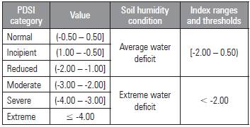
Martínez et al. (2016) conducted territorial studies of water excess and deficiency susceptibility in soil in order to construct an agroclimatic zoning methodology. They performed their analysis based on the conceptualization of agroclimatic risks by Field et al. (2012), integrating the soil requirements of a tomato crop and the monthly probability of the occurrence of moisture conditions in a soil with a water deficit. The water deficit analysis was done with a data series from the period between 1980 and 2011 using the Palmer Drought Severity Index (PDSI) during each of the crop development-cycle months. This methodology identified "productive niches" or potential areas for tomato production, i.e. areas that exhibited low soil limitations and low water deficit probability in the soil.
Given the importance of this region in Colombia given the dry agroecosystem characteristics, the type of natural cover, and the high degree of vulnerability, the aim of this study was to carry out agroclimatic zoning of the municipality of Uribia in order to define suitable agricultural development areas under conditions of a water deficit in the soil.
MATERIALS AND METHODS
Study area
Uribia is in the northernmost region of the Department of La Guajira, Colombia, between longitudes 71°05' and 72°23' W and latitudes 11°31' and 12°28' N, with an area of 787,202 ha (Fig. 1). Strong trade winds from the northeast, sand displacement, and low total annual precipitation volumes (<500 mm) result in a tropical desert biome with accentuated aridity conditions.
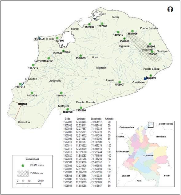
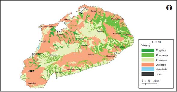
Figure 1 Location of meteorological stations used for agroclimatic zoning in the municipality of Uribia (PNN: National Natural Park).
The driest season of the year, when water deficiency conditions intensify, occurs between December and March as a consequence of dry northeast winds and the displacement of the ITCZ (Intertropical Convergence Zone) to the south. The rainy season occurs between August and November, as the ITCZ reaches its northernmost position (Eslava, 1993; Mesa et al., 1997).
The ET0 is always greater than the average rainfall, and moisture storage in the soil is minimal or null since the entire available supply is consumed by the high atmospheric demand. The soils are sodium saline, vulnerable to erosion, and have relatively limited fertility. The existing vegetation cover, dominated by desert scrub and sub-xerophytic forests, is subject to high temperatures (Pinilla and Zuluaga, 2014).
Agroclimatic zoning
The zoning was based on an analysis of land use suitability using the land evaluation scheme (ET) published by FAO (1976), the calculation of the probability of the occurrence of water deficit conditions in the soil based on the PDSI (Palmer, 1965), the study carried out by Martínez et al. (2016), and the availability and type of plant cover using Corine Land Cover (CLC) (IDEAM, 2012). Then, these analyses were integrated into monthly agroclimatic scenarios (AS). Finally, the AS was used to generate the agroclimatic zoning.
Land use suitability
The land use suitability for the plant species of interest (crops, pastures, and forages) in the agricultural production systems of Uribia was evaluated. The ET methodology was implemented on a general scale (1: 100,000), and physical and chemical soil characteristics were considered, as well as slope and natural drainage conditions, factors that are decisive for the development of agricultural activities. The information source for this evaluation was the general soil survey carried out by IGAC (2009) in the Department of La Guajira, with which the soil offer of land units (UdT) was identified. The edaphic requirements for the development of the agricultural systems were elucidated by consulting secondary information based on the databases of FAO and the Colombian Corporation for Agricultural Research (Agrosavia).
A decision tree was generated in order to determine soil suitability, divided into optimal (A1), moderate (A2), marginal (A3), and unsuitable (N) classes. After the identification of these use suitability classes in the municipality, they were grouped into three categories: suitable soils (classes A1 and A2), soils conditioned to management practices (with severe restrictions depending on the evaluated variables) (classes A2 and A3), and unsuitable soils (classes A3 and N).
Soil humidity conditions
The occurrence frequency of average water-deficit conditions was established, i.e. the prevalent condition in Uribia and the extreme water deficit in the soil associated with climate variability events such as the El Niño phenomenon. The monthly data series of precipitation, average maximum, medium and minimum temperature, relative humidity, and solar brightness was determined for the period 1980 to 2011. The information was gathered from 20 stations belonging to the meteorological observation network of the Colombian Institute of Hydrology, Meteorology, and Environmental Studies (IDEAM) in the study area (Fig. 1).
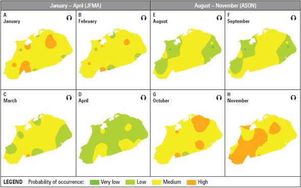
Based on the methodology of Martínez et al. (2016), the PDSI was calculated (Palmer, 1965), and index values were established for the average water deficit in Uribia (between -2.00 and 0.50) and for the extreme water deficit in this region (less than -2.00) (Tab. 1). Frequencies were calculated for the periods January to April (JFMA), the driest period of the year, and August to November (ASON), the rainiest period.
Table 1 PDSI categories that indicate average water deficit and extreme water deficit conditions for agricultural production systems in Uribia.
Based on the frequency of occurrence of the PDSI values from each of the climatological stations, the monthly probability of average water deficit was established for each four-month period, taking into account the entire series. Only PDSI values lower than -0.5 were assessed for extreme water deficit. Then, five levels were established in order to determine the frequency of occurrence of each water deficit condition as follows: very low (0-20%); low (20-40%); medium (40-60%); high (60-80%) and very high (80- 100%).
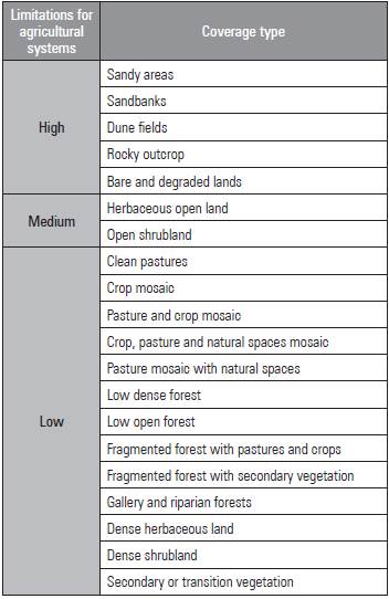
Land cover
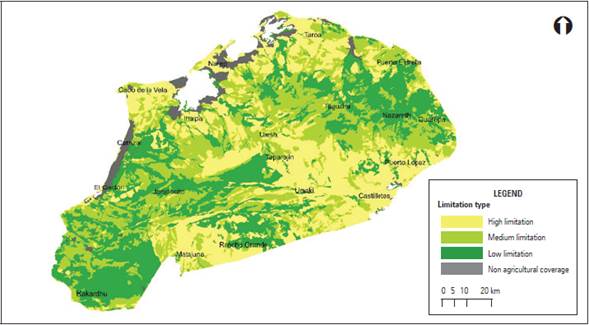
The different land cover types in the municipality were identified based on the thematic layer of land cover for the period 2005-2009 at a scale of 1:100,000, generated with the CLC methodology (IDEAM, 2012). The land cover types were classified into three categories based on their level of limitation for implementing agricultural systems (Tab. 2).
Monthly agroclimatic scenarios
Agroclimatic scenarios (AS) constitute a spatial monthly representation where use suitability, soil moisture conditions, and land coverage are integrated. The AS were constructed by overlapping with GIS geoprocessing tools, showing the behavior and dynamics of the soil moisture (extreme and average water deficit) during the analyzed periods (JFMA and ASON).
Agroclimatic suitability
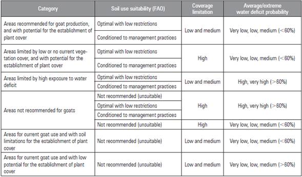
The areas with a low water deficit exposure were identified with the AS, that is, the areas that persistently exhibited a low and medium average water deficit and extreme water deficit frequencies of occurrence. The agroclimatic suitability was classified into six categories according to the ranges established in a qualification matrix (Tab. 3).
Table 3 Agroclimatic suitability qualification categories for goat production in the municipality of Uribia.
Finally, four agroclimatic suitability maps for agricultural systems in Uribia were elaborated.
RESULTS AND DISCUSSION
Soil use suitability
Most of the Uribia area exhibited restricted conditions for establishing and developing agricultural systems since more than 80% of the soils exhibited marginal suitability or were not suitable for agricultural uses. Only 3.7% of the soils were suitable (A1), while 15% had moderate suitability (A2), 31.5% were marginal (A3), and most, i.e. 49.8%, were not suitable (Fig. 2).
Humidity condition
Average water deficit
During the dry quarter, JFMA, the probability of occurrence of an average water deficit was mainly medium (40-60%) (Fig. 3: A, B, C, and D). The water deficit probability increased in February and March as a result of intensification of the dry period.
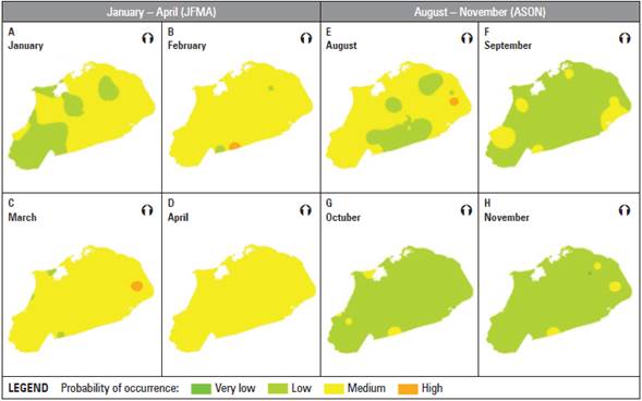
Figure 3 Monthly frequency of occurrence of average water deficit conditions in the soil of Uribia during the dry (JFMA) and the rainy (ASON) periods.
By contrast, during the ASON period, low probabilities of the occurrence of an average water deficit occurred in most of the municipality. Furthermore, during the months of September, October, and November, the probabilities did not exceed 40% (Figs. 3: E, F, G, and H).
Extreme water deficit
The frequency of occurrence of an extreme water deficit was mainly average (40%-60%) during the two periods (Fig. 4: A, B, C, and D). In comparison with the January-April period, during the rainy four-month period, a larger area of the municipality was exposed to a high frequency (60%-80%) of extreme water deficit conditions, mainly during October and November (Figs. 4: E, F, G, and H).
Land coverage
Shrub vegetation represents the most abundant cover type (48.4%) in Uribia, followed by the coverage associated with bare and degraded lands (25.6%). Thirty-four categories of land use were identified in the municipality and reclassified according to the limitations (Fig. 5).
Agroclimatic suitability for agricultural systems
Average water deficit condition
Under average water deficit conditions, approximately 171,000 ha (22% of the municipality) were identified as "areas recommended for goat production with potential for the establishment of vegetation cover" in the two evaluated periods (Fig. 6: A and B, and Tab. 4). These areas exhibited fewer limitations for the establishment and management of smaller species (i.e. goats). Moreover, they exhibited dense and continuous coverage (grasslands, shrubs, forests, pastures, and some crops) that provide a viable food supply for goats. They exhibited optimal soils for the system or for effective depth management practices: coarse textures, alkaline pH, compacted horizons, excessive drainage, salinity, and sodium content. The frequency of average water deficit conditions was predominantly low (<40%) although the probabilities were between 40% and 60%, indicating less exposure to water deficits for the species established in these zones. Under the average conditions in the municipality and considering factors such as soil, water deficit, and coverage, these areas have a lower agroclimatic risk for goat grazing and for the establishment of agricultural species that would ensure food security in the region.
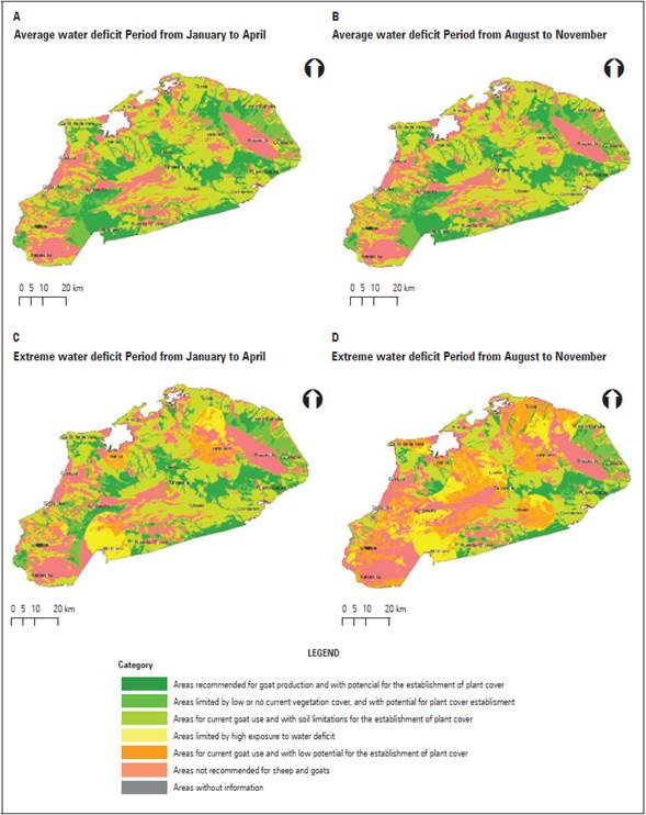
Figure 6 Agroclimatic suitability for goat production systems under: A) average water deficit conditions in the JFMA period; B) average water deficit conditions in the ASON period; C) extreme water deficit conditions in the JFMA period, and D) extreme water deficit conditions in the ASON period.
Table 4 Agroclimatic suitability for goats in the municipality of Uribia under two water deficit conditions.
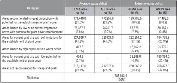
Nearly 75,000 ha in each four-month period corresponded to "areas limited by low or no current vegetation coverage and with potential for the establishment of vegetation cover" (Tab. 4). In these areas, there is currently not adequate plant cover for goat grazing. They are bare lands where the frequency of water deficits is less than 60% and where the soil, despite its limitations (at the effective depth level, texture, pH, compaction, drainage, salinity, and sodium), would allow for the establishment of a vegetation cover. The recommendation is to start planting shrubs, grasslands, and adapted forest species that could serve as a food source for goats in the medium term.
Around 21,000 ha scattered throughout the municipality were identified as having the greatest risk, i.e. cataloged as "areas not recommended for goats". There, the establishment of agricultural crops or even minor species is not recommended. The areas known as "areas for current goat use with soil limitations for the establishment of vegetation cover", which covered more than 40% of the municipality, have low and continuous coverage (mainly grasslands and shrubs) that can supply food to animals in the short term.
Extreme water deficit condition
When analyzing "areas recommended for the production of goats and with potential for the establishment of vegetation cover", under extreme water deficit conditions in the two evaluated periods, reductions of 35% (period JFMA) (Fig. 6C and D) and 55% (period ASON) were found, as compared to the 170,000 ha identified as having an average water deficit. During the first four-month period, approximately 130,000 ha were in this category.
Because of the significant reductions in the area with a lower agroclimatic risk, the ASON period was the most critical one since about 90,000 ha were no longer recommended for goat production, becoming "areas limited by high exposure to water deficit", where the high frequency of extreme water deficit conditions limits the establishment of plant species.
In general, the areas with the greatest agroclimatic risk for extreme water deficit conditions totaled between 306,000 and 513,000 ha for the JFMA and ASON periods, respectively (Tab. 4). This increase in the risk area for goat production resulted from the greater impact of extreme water deficit phenomena during the second semester of year. The greatest alteration in precipitation volume and maximum temperature were recorded between June and December as a result of events such as El Niño.
Vegetation growth and development varied depending on the humidity conditions and limitations in the soils for the establishment of vegetation cover. The nutritional status of goats was affected, generating malnutrition and low meat and milk production, which are main products of goats in this area (Roncallo, 2002). Furthermore, malnutrition conditions can be exacerbated by a lack of management practices (Islam et al., 2002).
Goat and sheep production systems have a wide range of adaptation under favorable and extreme weather conditions (Arbiza, 1986; Devendra, 2006, cited by Grajales et al., 2011); frequently, they are established in areas with climatic limitations (dry areas with low rainfall) and areas of low vegetation. However, the success of feeding these species is based on the efficient selection of the most nutritious parts of herbaceous and shrubby vegetation with a lower water requirement because of the ability to concentrate and reduce the volume of urine, evaporation of feces, and reduction of water losses through evaporation, as reflected in a higher digestibility of fiber-rich foods (Grajales et al., 2011). Therefore, it is necessary to generate alternatives for the management of goats and sheep that guarantee a food supply and security in communities since this production system represents 60% of the meat diet of the inhabitants (Márquez, 2006).
Agroclimatic suitability zoning is in line with the proposal by Gupta (1992) and the concept of zooclimatic regions, incorporating factors inherent to the development of a goat-productive system, such as species preference and ecological niches, considering the diversity of biomass sources such as trees, shrubs, or pastures (protein banks). Moreover, the developed zoning incorporates water balance and land cover elements, as does the zoning used in pasture suitability studies, such as those developed following the FAO method (1991), where emphasis is placed on forage production, water resources, and soil sensitivity to erosion (Amiri et al., 2012; Keno and Suryabhagavan, 2015). Although agroclimatic suitability zoning is a characterization tool, it is more accurate if there is soil, climate, and land cover data on detailed scales. In addition, it must be accompanied by feedback from system information that allows decisions to be made (from producers to rural planners).
CONCLUSIONS
In the municipality of Uribia, under average water-deficit conditions, around 171,000 ha were identified as having the lowest agroclimatic risk, recommended for goat production with the potential to establish plant cover. Furthermore, 75,000 ha were identified as areas with the potential for the establishment of vegetation cover.
Under extreme water deficiency conditions, the recommended areas for goat production varied according to the four-month period (the highest and lowest volume of average rainfall). The largest available area was in the JFMA (January to April) period (approximately 130,000 ha), while for the ASON (August to November) period, the available area was much smaller (approximately 77,000 ha), showing the impact of an extreme water deficit phenomenon in the second semester, where the average rainfall volumes were drastically reduced.
Currently, most of the producers are located in areas with limited soil conditions that are not recommended for this land use because of average water-deficit conditions and low extreme water-deficit conditions that are subject to high exposure to water-deficit conditions and are strongly limited by soils, with little food source availability. Local adaptation strategies need to be developed to mitigate the impact of these conditions, identify alternative areas for mobilizing ethnic communities and minimize animal losses and risks for food security, thereby improving the livelihood of the locals.


