


 English (pdf)
 Article in xml format
 Article references
 Send this article by e-mail
 Cited by SciELO
  Cited by Google
  Similars in
SciELO
Similars in
SciELO  Similars in Google
 Permalink
INTRODUCTION
Colombia is a critical country for jaguar conservation because it is the intercontinental bridge between Mesoamerican and South America genetic pools, but due to large-scale habitat conversion, intensive hunting, illegal trafficking, fragmentation, the construction of highways and infrastructure, jaguars in Colombia are considered a threatened species (Figel et al., 2019; Quigley et al., 2017). Jaguars have a functional role in that they maintain the ecosystem's integrity and functions, therefore conservation efforts are important, but although efforts have been made, their populations are still declining (Boron et al., 2019).
There are several possible drivers behind this change. Tropical regions had the highest rates of deforestation during 2000-2012 that was mostly a result of various complex factors including human-wildlife conflicts as well as loss of landscape connectivity (Figel et al., 2019). This is particularly relevant to jaguars as they are the largest terrestrial carnivore in the Neotropics and usually move through tropical lowland habitats with high amounts of forest cover in tropical moist biome, tropical dry forests, coastal mangroves, and herbaceous lowland grasslands (Figel et al., 2019; Gese et al., 2018). However, Panthera onca is one of the least adaptable predators to habitat fragmentation. This species also has a strong association with rivers and wetland areas, which provide prey or refuge. Even though forests are not the main habitat for jaguars, they do use them as a corridor to move throughout their territory and connect with other jaguar population (Castillo Martínez, 2016).
In recent years, the anthropogenic pressure has increased and is affecting jaguar individuals ability to connect with other populations and even to find prey. According to Figel et al., (2019), the amount of jaguars has decreased by 54 % in their range, which now spans 18 countries from Mexico to Argentina. This decrease indicates that the jaguars’ ability to move and disperse due to human-dominated landscapes is becoming difficult despite its adaptability, because forest corridors have become fragmented, were these fragments containing small, isolated populations (Haag et al., 2010; Figel et al., 2019; Gese et al., 2018; Payán et al., 2010). Jaguars however require large areas, and if not, they have low reproductive rates and densities, making them vulnerable to extinction (Boron et al., 2018; Quigley et al., 2017).
Moreover, intensive hunting, illegal trafficking, habitat fragmentation, the construction of highways and infrastructure are also some of the biggest threats to jaguar habitat (Marchini & Macdonald, 2012). Even though studies of habitat loss and conservation ofP. oncahave been conducted to identify potential areas for conservation and educational activities within the urban and rural communities inside areas of the Sistema Nacional de Áreas Protegidas, SINAP (National System of Protected Areas), the geographical distribution of jaguars outside protected areas is still unknown (Boron et al., 2018; Petracca et al., 2014). Moreover, studies have not identified the exact areas of movement and their area, thus making it more difficult to understand habitat conditions and population distribution, frontiers, and parameters (Figel et al., 2019). Given all these changes and impacts to habitat, measures in these tropical regions must be taken in order to preserve and conserve the jaguar (Boron et al., 2018; Rabinowitz & Zeller, 2010).
However, the lack of information about jaguar distribution and poor landscape-level planning in Colombia can affect conservation strategies (Zárrate-Charry et al., 2018). Therefore the conservation of forested areas and wetlands (Boron et al., 2018) is key to better understandP. oncadistribution, populations, corridors and how they overlap (Thornton et al., 2016). Furthermore, the fact that Colombia was at war for 50 years with guerrilla groups, means that some of the habitat areas have never or been little studied until 2016 (Zárrate-Charry et al., 2018; Boron et al., 2018; Boron et al., 2019). Due to the ecological importance of this species, organizations like Red Colombiana de Seguimiento de Fauna Atropellada (RECOSFA) have proposed the establishment of wildlife corridors. But again, little is known as to what is driving these changes and where corridors could be established. The overall objective of this study is to spatially analyze the extent to which the current distribution and access toP. oncahabitat is being affected by different anthropogenic activities and if they are being driven by either deforestation, armed conflict, agriculture expansion, urbanization and the construction of highways in the Bajo Magdalena area of Colombia.
METHODOLOGY
Area of study
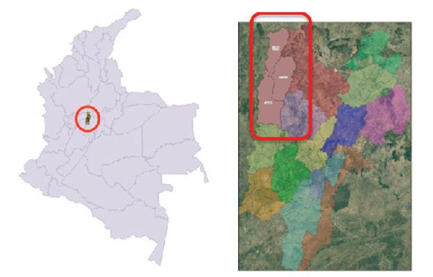
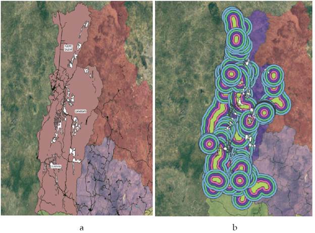
Colombia covers an area of 1.1 million km2 (Castro-Nunez et al., 2017) and is a mega biodiversity hotspot that hosts a variety of ecosystem types such as forest ecosystems that covers about 52.20 % of its area and 6 % of the forest cover of Latin America. Colombia has different types of landscapes such as hills (35 %), mountains (26 %), valleys, and plains (20 %) (Ramírez Delgado et al., 2018). Even though, this species can be found across the Amazonia, the Orinoquia, the biogeographic Chocó, the Caribbean, and the inter-Andean valley regions, which represent 33 % of the country area, they are rarely found in the Andean region, but some isolated populations are present in in Yacopí, Puerto Salgar, Caparrapí and Guaduas, which correspond to Bajo Magdalena area, located at 5°25'42.1"N 74°34'45.6"W (Figure 1) (Castillo Martínez, 2016).
Accordingly, we selected the Bajo Magdalena region as our study area because the population of jaguars is being affected by rapidly occurring anthropogenic changes such as small-large urban and rural areas, increasing human populations, agriculture activities, infrastructure developments, such as major roads and other drivers related to deforestation (Castillo Martínez, 2016). Moreover,P. oncapopulation is decreasing in Bajo Magdalena due to many isolated populations that are still increasing (Castillo Martínez, 2016). Therefore, is important to establish corridors between these isolated populations to maintain the jaguar's corridor and the genetic drift between them by implementing conservation strategies.
As part of this analysis, we used information from the Instituto de Investigación de Recursos Biológicos Alexander von Humboldt, Departamento Administrativo Nacional de Estadística (DANE), and Instituto Nacional de Vías (Invías). We also estimated deforestation based on global coverage provided by Hansen et al., (2014). This data was used in vector format (. * Shp), and was reprojected to the MAGNA SIRGAS system-3116 (Table 1) to allow subsequent analyses. We used Qgis V.3.4 software to calculate the vector layers for the municipalities of Caparrapí, Puerto Salgar, and Guaduas, to determine theP. oncadistribution in Bajo Magdalena, with this information we measured the total area.
Table 1 Variables used for explaining jaguar distribution and area, and deforestation patterns
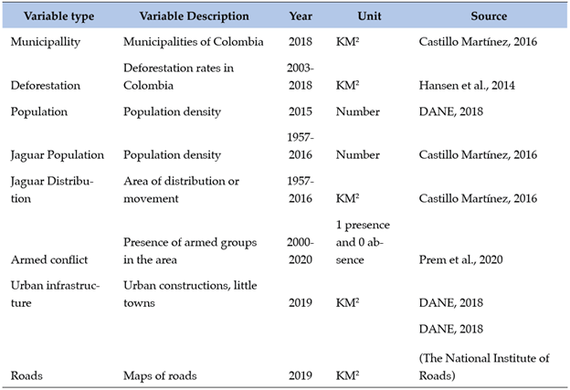
Source: Own elaboration.
We analyzed the distance and distribution of the species using data from Table 1 and deforested areas adjacent to urban areas in the study area. Specifically, we studied 19 urban areas in Bajo Magdalena with an area of influence of 5 km, and we divided these areas into 5 buffer rings of 1 km each to determine the distance to the P. onca territory.
Additionally, we also estimated the deforested area within these populations, using raster data of forest cover change during the analysis periods of 2000 and 2018, with a pixel size of 27.88 m. Roads that were associated with each municipality and the concentric rings were also accounted for in order to calculate the total area affected by transportation infrastructure. Then, we determined the total area affected by the different drivers in the 5 rings.
Finally, we also calculated the impacts on the distribution ofP. oncain the main and secondary pathways in the study area. We used a similar method to calculate the population of the jaguars based on rings of influence using the same patterns, between 1 and 5 km among roads. We found that the rings overlapped and intersected roads into segments. This analysis generated duplication of the data; thus, to avoid this we only counted the ring of influence closest to the distribution ofP. onca. Finally, we developed a spatial correlation statistical analysis to identify the spatial relationship between the study areas and areas that affect the distribution of theP. onca. To explain this, we made a database with the number of jaguar populations, and then added the number of the studied population in areas that affect the distribution of theP. oncato maintain the equivalent unit as the municipalities. Besides, we also used this data to evaluate the effects of roads for jaguars, deforestation, and the area ofP. oncadistribution (GeoDa software).
RESULTS
The total area of the distribution of P. onca is in the three municipalities of interest were 43.77, 30.73, and 30.72 km2 in the Caparrapí, Puerto Salgar, and Guaduas municipalities, respectively. It can be noted that the difference between these areas is small, given that they are an area of great influence and importance within the ecological corridor of P. onca. These areas in total represent 105.2 km2.
Figure 2 shows P. onca distribution areas (white areas), and the five rings created around the populations and populated centers of the municipalities studied. As figure 2 shows, they are conflict zones along Bajo Magdalena, especially in the central and southern zones. Therefore, we found fewer jaguar populations in the north and it extends to the east. We can also evidence that only a small fragment of the distribution is not in contact with the human population because of their distance.
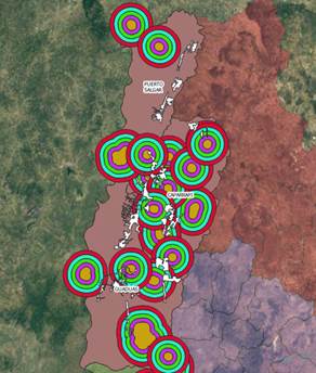
Source: Own elaboration. Note: The orange circles represent the urban population, and the other colors 5 km concentric rings around the urban center. White fragments represent P. onca distribution area or corridor.
Figure 2 Areas of influence of populations and distribution areas
The total area of distribution within each analyzed ring is shown in Table 2. According to this, the urban settlements that have the highest influence areas for the jaguar distribution are Cambras, San Ramón Alto, and Guaduero, with more than 10 km2 of distribution within the direct area of the population. These results show that even at distances up to 1 km2 we can find a jaguar distribution area. Besides, it was found that out of 12 urban populations studied, 7 occupy 72 % of Bajo Magdalena, and affects the distribution area of P. onca in the 5 km buffer zones.
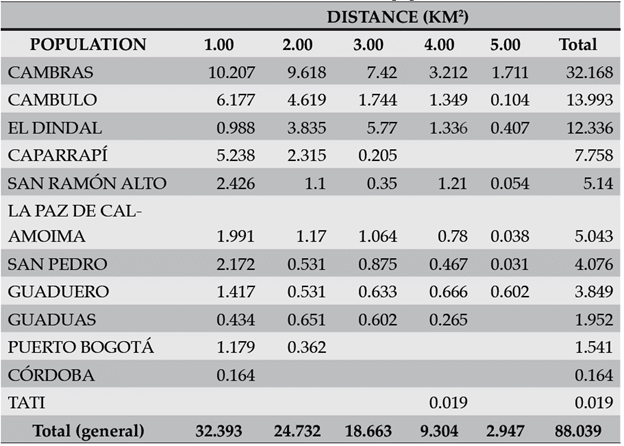
As Table 2 shows, out of 105 km2 of jaguar distribution, 88 km2 intersect within the 5km buffer zones. This means that 83% of the distribution area intersects the buffer areas.
Overall, we found a total of 47.9 km2 of deforestation, where 5.6 km2 are within the P. onca distribution area. However, this value is found in strategic areas for connectivity between jaguar populations.
Figure 3 shows the vector information used for the analysis of the influence of the roads, both local and inter-municipal, finding that 99.7 km2 of the total are being affected by these, especially in connectivity between municipalities. Once the analysis was carried out, we found that the municipalities of Caparrapi and Guaduas have more prominent effects onP. oncadistribution, with a 41.3 and 33.2 km2 respectively. Besides, we noticed that the most troubled areas of jaguar distribution are 1-3 km2 away within these municipalities, which suggests that the roads are very close toP. oncapopulation, which can explain the difficulty of jaguar interaction between two different populations due to fragmentation.
Source: Own elaboration. Note: a) Distribution areas and roads. b) Areas of influence of the roads. White fragments represent P.onca distribution area or corridor. Black lines, represent roads.
Figure 3 Spatial analysis from the influence of the roads
Table 3 shows the effects of P. onca distribution by ring and municipality within the intersection between roads and distribution areas of P. onca. As table 3 shows, 87.5 km2 of the distribution area of the P. onca is affected by primary and secondary roads, which represents 83.1 % of the total area of distribution of P. onca.
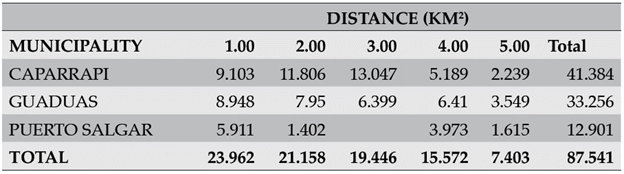
Table 3 shows the direct relationship among roads and their connectivity toward jaguar populations, which intersect 5 km of the total distribution area of theP. oncadue to the spatial distribution and growth of the studied municipalities. Since these municipalities require connectivity between them, jaguar populations become isolated as a result of the construction of roads. Nonetheless, the impact, influence, and the type of road are different regardingP. onca distribution, and habitat. The greatest impact among this is found in the highways or roads that connect the largest municipalities through national roads, other roads that connect urban areas and rural have a lower impact because some of them are unpaved, which allows the movement of P. onca, although the greater probability of being run over.
Model
Table 4 shows the correlation between variables and that there is a positive relationship between the influence of jaguar populations and their distribution area in the 5 km studied, the highest values of influence on roads are between the 2 and 3km rings, and at a greater distance, the correlation decreases.
Table 4 Correlation between the variables studied and the area of distribution
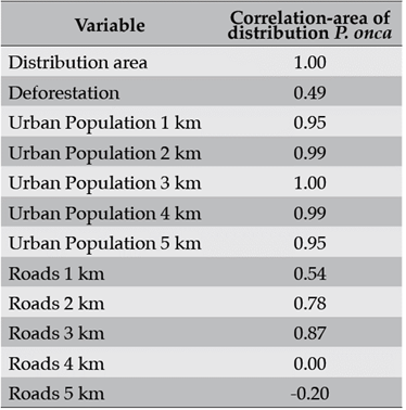
Source: Own elaboration.
Then, we made a spatial statistics analysis with the Bivariant dwell index to determine the relationship within the variables, and the effects on their neighbors spatially. To do this we used the queen contiguity for the connectivity analysis in all directions. As Figure 4 shows, we made a map of significance to establish the relationship between a municipality and its neighboring municipalities to determine the variables that affect the distribution area of the jaguar in a ring of a kilometer. For 2 of the 3 municipalities studied, the low-high combination indicates that when the relationship in a municipality between the populations of the jaguar is low and the distribution area of the jaguar is high, its neighbors also have this relationship.
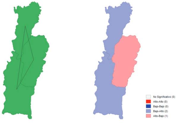
Source: Own elaboration. Note: a) Spatial connectivity of the Municipalities of Bajo Magdalena. b) Example of the Moran Bivariante Index between the distribution area and the population in the 1 km ring.
Figure 4 Maps connectivity and Moran index
In the variables studied, there are no high-high spatial relationships, which means that the variables are not spatially related, and the distribution of P. onca is affected only by the variables already described, but they are not related in space. This spatial relationship is evident, despite being significant it has few observations, which can affect the result.
DISCUSSION
This study used spatially explicit analyses and available geospatial data to determine the spatial extent ofP. oncahabitat and how deforestation, armed conflict, agriculture expansion, urbanization and the construction of highways are affecting its habitat and distribution in the Bajo Magdalena area of Colombia. Our findings show that urbanization and the construction of highways were highly influential variables associated with the loss of the jaguar (Panthera onca) habitat, especially in the urban areas of Cambras, San Ramon Alto and Guaduero (Figure 2), which manifest an intersection with jaguars and the human settlements, which is common due to the highly transform areas (Zárrate-Charry et al., 2018). Thus, highways and different types of roads of Puerto Salgar, Caparrapi and Guaduas affect 87.7 km2 of jaguar territory (Table 3). Even though jaguars intend to avoid human areas, due to landscape transformation this lack of interaction is impossible because forest and swamp areas become limited, which makes it easier to predict their connectivity with other jaguar populations and their closeness to human areas (Thornton et al., 2016; Zárrate-Charry et al., 2018).
In addition, our results also show a correlation between variables and a positive relationship between the influence of jaguar populations and their distribution area in the 5 km studied around the urban areas (Table 4). This implies that measures need to be taken considering that habitat loss due to forest conversion such as roads and agriculture generate conflict between jaguar and humans by increasing disputes between them as a result of the reduction and difficulty of jaguar movement (Zárrate-Charry et al., 2018, Benítez Gutiérrez, 2010; Thornton et al., 2016; Marchini & Macdonald, 2012). Through identifying the distribution area ofP. onca we analyzed the landscape distribution between the municipalities of Bajo Magdalena. By doing this we established different categories that could influence jaguar distribution. We evaluated the presence of Natural Parks in the area, swamps, infrastructure projects (polyducts), railway, and the influence of inter-municipal buses.
As we evaluated, there is presence of jaguars in the SINAP Cuchilla de San Antonio, and there are isolated and difficult areas for jaguar to cross because of roads, infrastructure, and human settlements. Thus, we identify connections of forest areas within the riparian forest. For instance, we suggest thatP. oncamay be adapting to highly transformed areas by using them to move and avoid human interaction (Pardo-Vargas & Payán-Garrido, 2015). As it is well known, jaguar distribution area is being affected by crops, infrastructure, and highways (Zárrate-Charry et al., 2018; Petracca et al., 2014), and their distribution and interaction with other members of the population is becoming difficult, generating isolation (Roques et al., 2016). However, there has been some evidence that the jaguar is adapting to some unconventional landscapes such as oil-palm crops (Figel et al., 2019; Pardo-Vargas & Payán-Garrido, 2015; Boron et al., 2016) and riparian forest to avoid total isolation among different jaguar populations.
Therefore, there are remote populations of jaguars in the Bajo Magdalena area, and as Figures 2 and 3 show, these areas might restrict jaguar distribution due to railways, highways and urban population in the area; yet there are some additional pressures, such as deforestation, that may restrict jaguar distribution and their fitness. Even though jaguars require a large territory, having limited access to their territory may affect the gene flow in isolated populations (Rabinowitz & Zeller, 2010). As our results in Figures 2 and 3 show, the geographic distance and the difficulty of access between populations due to habitat deterioration may cause a decline in the number of Jaguars per area (Roques et al., 2016).
Moreover, P. oncais a nocturnal feline, which means that the movement and hunting take place mostly at night (Castillo Martínez, 2016). However, these roads and highways are currently used mostly in the daytime, which means they generate constant traffic noise. Thus, due to the behavior of this feline, it will not attempt to approach or travel on roads highly attended by humans, which affect jaguar habitat distribution, making the population more isolated (Roques et al., 2016). Adding to this fact, inter-municipal routes and some trucks travel with less regulation at night, which is the jaguar's hour of mobility (Castillo Martínez, 2016). When not listening to sound, the probability that the jaguar is confident when crossing is greater, which settle them in a vulnerable position. Yet, land use and land-use change were also influential factors in the analysis. The transformation among dense forest and bush areas can change the distribution ofP. oncaand how it relates to other jaguar populations. Infrastructure, transportation, and the human population makes them even more vulnerable. Despite the drivers of deforestation and the isolation of the jaguar population, we can establish some main factors and changes that can help preventingP. oncapopulation loss and avoid their isolation by establishing bushes and trees corridors, and palm oil crops so that they can move easily and in a larger area.
CONCLUSION
Landscape transformation and the change in land use are increasing the isolation of jaguar populations. Roads, agricultural expansion, and urban areas are some of the anticipated mechanisms of isolation among jaguars. However, due to these landscape changes, jaguars have developed a strategy by moving through highly transformed forests, mostly riparian forests, but we propose that precautions along the principal road that connects Puerto Salgar and Guaduas should be taken into consideration in order to maintain the genetic flow and movement of the P. onca population as it affects 87 km of this proposed corridor. Through using geospatial tools we can provide an insight into the different jaguar threat drivers by identifying conflict zones and the reasons for potential habitat loss, as well as the possibility of generating optimal ecological niche proposals and monitoring of proposed conservation plans. We concluded that conservation initiatives must be implemented inside jaguars’ distributional range and buffer zones. Finally, these analyses help to get an overview of various factors that can explain how indirect and direct factors may impactP. oncaand its habitat, such as the change in land use and the change of area, that restricts the movement of the species.

