<?xml version="1.0" encoding="ISO-8859-1"?><article xmlns:mml="http://www.w3.org/1998/Math/MathML" xmlns:xlink="http://www.w3.org/1999/xlink" xmlns:xsi="http://www.w3.org/2001/XMLSchema-instance">
<front>
<journal-meta>
<journal-id>0012-7353</journal-id>
<journal-title><![CDATA[DYNA]]></journal-title>
<abbrev-journal-title><![CDATA[Dyna rev.fac.nac.minas]]></abbrev-journal-title>
<issn>0012-7353</issn>
<publisher>
<publisher-name><![CDATA[Universidad Nacional de Colombia]]></publisher-name>
</publisher>
</journal-meta>
<article-meta>
<article-id>S0012-73532010000100013</article-id>
<title-group>
<article-title xml:lang="en"><![CDATA[GEOENVIRONMENTAL CHARACTERIZATION OF THE SAN QUINT ÍN MINE TAILINGS, CIUDAD REAL ( SPAIN )]]></article-title>
<article-title xml:lang="es"><![CDATA[CARACTERIZACIÓN GEOAMBIENTAL DE LA BALSA DE LODOS DE LA MINA DE SAN QUINTÍN (CIUDAD REAL)]]></article-title>
</title-group>
<contrib-group>
<contrib contrib-type="author">
<name>
<surname><![CDATA[GÓMEZ-ORTIZ]]></surname>
<given-names><![CDATA[DAVID]]></given-names>
</name>
<xref ref-type="aff" rid="A01"/>
</contrib>
<contrib contrib-type="author">
<name>
<surname><![CDATA[MARTÍN-CRESPO]]></surname>
<given-names><![CDATA[TOMÁS]]></given-names>
</name>
<xref ref-type="aff" rid="A02"/>
</contrib>
<contrib contrib-type="author">
<name>
<surname><![CDATA[ESBRÍ]]></surname>
<given-names><![CDATA[JOSÉ MARÍA]]></given-names>
</name>
<xref ref-type="aff" rid="A03"/>
</contrib>
</contrib-group>
<aff id="A01">
<institution><![CDATA[,Universidad Rey Juan Carlos Área de Geología ]]></institution>
<addr-line><![CDATA[ ]]></addr-line>
</aff>
<aff id="A02">
<institution><![CDATA[,Universidad Rey Juan Carlos Área de Geología ]]></institution>
<addr-line><![CDATA[ ]]></addr-line>
</aff>
<aff id="A03">
<institution><![CDATA[,Universidad Castilla-La Mancha Dpto. Ingeniería Geológica y Minera ]]></institution>
<addr-line><![CDATA[ ]]></addr-line>
</aff>
<pub-date pub-type="pub">
<day>00</day>
<month>03</month>
<year>2010</year>
</pub-date>
<pub-date pub-type="epub">
<day>00</day>
<month>03</month>
<year>2010</year>
</pub-date>
<volume>77</volume>
<numero>161</numero>
<fpage>131</fpage>
<lpage>140</lpage>
<copyright-statement/>
<copyright-year/>
<self-uri xlink:href="http://www.scielo.org.co/scielo.php?script=sci_arttext&amp;pid=S0012-73532010000100013&amp;lng=en&amp;nrm=iso"></self-uri><self-uri xlink:href="http://www.scielo.org.co/scielo.php?script=sci_abstract&amp;pid=S0012-73532010000100013&amp;lng=en&amp;nrm=iso"></self-uri><self-uri xlink:href="http://www.scielo.org.co/scielo.php?script=sci_pdf&amp;pid=S0012-73532010000100013&amp;lng=en&amp;nrm=iso"></self-uri><abstract abstract-type="short" xml:lang="en"><p><![CDATA[The abandoned San Quintín mining group ( Ciudad Real) was operated by the Sociedad Minero-Metalúrgica de Peñarroya, and 515.300 tons of galena concentrates were obtained between 1888 and 1923. Two geophysical surveys, using electrical resistivity imaging (ERI) and ground-penetrating radar, as well as mineralogical and geochemical techniques have been used in order to obtain a geo-environmental characterization of the mine pond. The ERI has allowed us to determine both the general geometry of the pond’s substrate and a maximum thickness of the mine tailings of 12 m. Tailings are medium-to-coarse grained materials mainly composed of quartz, clay minerals, gypsum and feldspars. Neither acid mine drainage nor modification of their internal structure have been detected. The amount of ore minerals in the tailings have been greatly reduced because of their reworking. Joint application of geophysical and geochemical techniques has revealed as very useful for obtaining a complete characterization of abandoned mine deposits, previously to a future reclamation of these hazardous tailings.]]></p></abstract>
<abstract abstract-type="short" xml:lang="es"><p><![CDATA[El grupo minero de San Quintín (Ciudad Real), del que la Sociedad Minero-Metalúrgica de Peñarroya extrajo 515.300 toneladas de concentrados de galena entre 1888 y 1923, se encuentra actualmente abandonado. Para la caracterización geoambiental de una balsa de lodos de este grupo minero, se han utilizado dos técnicas geofísicas someras, tomografía eléctrica 2D y georadar, y técnicas mineralógicas y geoquímicas. Se han determinado los límites de la balsa, un espesor máximo de relleno de unos 12 m, y que está constituido por materiales de granulometría arenoso-arcillosa formados principalmente por cuarzo, minerales del grupo de la arcilla, yeso y feldespatos. No se han detectado indicios de drenaje ácido en la balsa ni de modificación de su estructura interna. Los trabajos últimos de relavado han reducido la cantidad de minerales metálicos en los lodos. El uso combinado de técnicas se muestra muy útil en la caracterización de depósitos mineros abandonados, paso previo a los trabajos futuros de restauración ambiental de este tipo de residuos medioambientalmente peligrosos.]]></p></abstract>
<kwd-group>
<kwd lng="en"><![CDATA[tailing pond]]></kwd>
<kwd lng="en"><![CDATA[electrical resistivity tomography]]></kwd>
<kwd lng="en"><![CDATA[geochemistry]]></kwd>
<kwd lng="en"><![CDATA[ground-penetrating radar]]></kwd>
<kwd lng="en"><![CDATA[San Quintín]]></kwd>
<kwd lng="es"><![CDATA[balsa de lodos]]></kwd>
<kwd lng="es"><![CDATA[tomografía eléctrica]]></kwd>
<kwd lng="es"><![CDATA[geoquímica]]></kwd>
<kwd lng="es"><![CDATA[georadar]]></kwd>
<kwd lng="es"><![CDATA[San Quintín]]></kwd>
</kwd-group>
</article-meta>
</front><body><![CDATA[ <p align="center"><b><font size="4" face="Verdana, Arial, Helvetica, sans-serif">GEOENVIRONMENTAL  CHARACTERIZATION OF THE SAN QUINT &Iacute;N MINE TAILINGS, CIUDAD REAL ( SPAIN ) </font></b></p>      <p align="center"><b><font size="3" face="Verdana, Arial, Helvetica, sans-serif"><i>CARACTERIZACI&Oacute;N GEOAMBIENTAL DE LA BALSA DE LODOS DE LA MINA  DE SAN QUINT&Iacute;N (CIUDAD REAL)</i></font></b></p>      <p align="center">&nbsp;</p>     <p align="center"><font size="2" face="Verdana, Arial, Helvetica, sans-serif"><b>DAVID G&Oacute;MEZ-ORTIZ</b>    <br> <i>&Aacute;rea de Geolog&iacute;a, ESCET, Universidad Rey Juan Carlos, Madrid, <a href="mailto:david.gomez@urjc.es">david.gomez@urjc.es </a></i></font></p>     <p align="center"><font size="2" face="Verdana, Arial, Helvetica, sans-serif"><b>TOM&Aacute;S MART&Iacute;N-CRESPO</b>    <br>   <i>&Aacute;rea de Geolog&iacute;a, ESCET, Universidad Rey Juan Carlos, Madrid,   <a href="mailto:tomas.martin@urjc.es">tomas.martin@urjc.es</a> </i></font> </p>     <p align="center"><font size="2" face="Verdana, Arial, Helvetica, sans-serif"><b>JOS&Eacute; MAR&Iacute;A ESBR&Iacute;</b>    <br> </font><font size="2" face="Verdana, Arial, Helvetica, sans-serif"><i>Dpto. Ingenier&iacute;a Geol&oacute;gica y Minera, Universidad Castilla-La Mancha, Ciudad Real, <a href="mailto:JoseMaria.Esbri@uclm.es">JoseMaria.Esbri@uclm.es</a></i></font></p>     <p align="center">&nbsp;</p>     ]]></body>
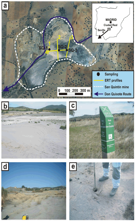
<body><![CDATA[<p align="center"><font size="2" face="Verdana, Arial, Helvetica, sans-serif"><b>Received for review June 17 <sup>th</sup>, 2009, accepted December    21<sup>th</sup>, 2009, final version January 7 <sup>th</sup>, 2009</b></font></p>     <p align="center">&nbsp;</p> <hr>     <p><font size="2" face="Verdana, Arial, Helvetica, sans-serif"><b>ABSTRACT</b>: The abandoned San Quint&iacute;n mining group    (    Ciudad Real)    was operated by the Sociedad Minero-Metal&uacute;rgica    de Pe&ntilde;arroya, and 515.300 tons of galena concentrates were obtained between    1888 and 1923. Two geophysical surveys, using electrical resistivity imaging    (ERI) and ground-penetrating radar, as well as mineralogical and geochemical    techniques have been used in order to obtain a geo-environmental characterization    of the mine pond. The ERI has allowed us to determine both the general geometry    of the pond’s substrate and a maximum thickness of the mine tailings of 12 m.    Tailings are medium-to-coarse grained materials mainly composed of quartz, clay    minerals, gypsum and feldspars. Neither acid mine drainage nor modification of    their internal structure have been detected. The amount of ore minerals in the    tailings have been greatly reduced because of their    reworking. Joint application of geophysical and geochemical techniques has revealed    as very useful for obtaining a complete characterization of abandoned mine  deposits, previously to a future reclamation of these hazardous tailings.</font></p>     <p><font size="2" face="Verdana, Arial, Helvetica, sans-serif"><b>KEYWORDS</b>: tailing pond, electrical resistivity tomography, geochemistry, ground-penetrating radar, San Quint&iacute;n.</font></p>     <p><font size="2" face="Verdana, Arial, Helvetica, sans-serif"><b>RESUMEN: </b>El grupo minero de San Quint&iacute;n (Ciudad Real),    del que     la Sociedad Minero-Metal&uacute;rgica de Pe&ntilde;arroya extrajo    515.300 toneladas de concentrados de galena entre 1888 y 1923, se encuentra    actualmente abandonado. Para la caracterizaci&oacute;n geoambiental de una balsa de    lodos de este grupo minero, se han utilizado dos t&eacute;cnicas geof&iacute;sicas someras,    tomograf&iacute;a el&eacute;ctrica 2D y georadar, y t&eacute;cnicas mineral&oacute;gicas y geoqu&iacute;micas. Se    han determinado los l&iacute;mites de la balsa, un espesor m&aacute;ximo de relleno de unos    12 m, y que est&aacute; constituido por materiales de granulometr&iacute;a arenoso-arcillosa    formados principalmente por cuarzo, minerales del grupo de la arcilla, yeso y    feldespatos. No se han detectado indicios de drenaje &aacute;cido en la balsa ni de    modificaci&oacute;n de su estructura interna. Los trabajos &uacute;ltimos de relavado han    reducido la cantidad de minerales met&aacute;licos en los lodos. El uso combinado de    t&eacute;cnicas se muestra muy &uacute;til en la caracterizaci&oacute;n de dep&oacute;sitos mineros    abandonados, paso previo a los trabajos futuros de restauraci&oacute;n ambiental de este tipo de residuos medioambientalmente peligrosos.</font></p>     <p><font size="2" face="Verdana, Arial, Helvetica, sans-serif"><b>PALABRAS CLAVE</b>: balsa de lodos, tomograf&iacute;a el&eacute;ctrica,  geoqu&iacute;mica, georadar, San Quint&iacute;n.</font></p> <hr>     <p>&nbsp;</p>     <p><font size="3" face="Verdana, Arial, Helvetica, sans-serif"><b>1. INTRODUCTION </b></font></p>     <p><font size="2" face="Verdana, Arial, Helvetica, sans-serif">Mine tailings are watery sludges composed of    medium-to-fine-grained material, resulting from grinding and mineral processing (e.g., galena, pyrite,</font> <font size="2" face="Verdana, Arial, Helvetica, sans-serif">chalcopyrite,    arsenopyrite). They are piled up as less than 5 cm thick sedimentary levels,    differentiated by slight granulometric and/or compositional differences. They entail both</font> <font size="2" face="Verdana, Arial, Helvetica, sans-serif">an accumulation and a potential subsequent emission    source of trace elements (Cu, Fe, Pb, Zn,…) with formation of acid drainage due    to oxidation of the sulphides present in the mine tailings, either because they    were not sufficiently benefited or due to the existence of a deficient    extractive technology by the time they were exploited. Mine ponds are,    therefore, an important environmental problem, all the more if they constitute    abandoned deposits. Previous similar works have focused on the study of potentially hazardous metals (e.g. &#91;1&#93;).</font></p>     <p><font size="2" face="Verdana, Arial, Helvetica, sans-serif">The selected area, the San    Quint&iacute;n mine tailings, is located to the north of     Puertollano,    in the Ciudad Real province, Spain (<a href="#fig01">Fig. 1a,    b</a>). This sludge pond is crossed by the Don Quixote Route, a tourist set of itineraries    that the local government drawn up in 1995 in order to celebrate the IV    Centenary of the publishing of “El ingenioso hidalgo Don Quijote de La mancha”   (<a href="#fig01">Fig. 1c</a>). This route, the longest ecotourist way in    Europe,   has already been declared as Cultural Itinerary by the Council of Europe, and   soon it could reach the rank of Humanity Heritage because of its environmental   and cultural goodness. These features therefore make the San Quint&iacute;n mining    group a busy tourist itinerary. That is the reason why an environmental    characterization of it in order to determine its potential hazard is so necessary.</font></p>     ]]></body>
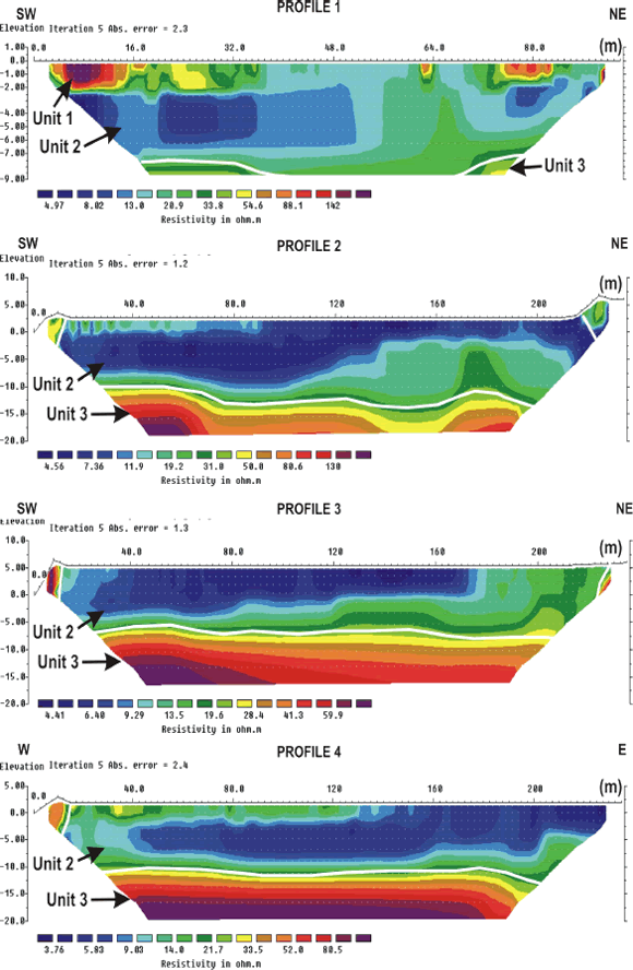
<body><![CDATA[<p><font size="2" face="Verdana, Arial, Helvetica, sans-serif">In this work we have applied mineralogical and    geochemical characterization techniques (X-Ray Diffraction and X-Ray    Fluorescence) and shallow, non destructive geophysical techniques (Electrical    Resistivity Imaging and Ground Penetrating Radar) to get a detailed picture of    the mine pond geometry, composition and thickness of its infilling, possible existence of water flows within it and    occurrence of acid mine drainage leaks. The study has been carried out in order    to characterize the present condition of the pond previously to the hypothetical reclamation.</font></p>     <p>&nbsp;</p>     <p><font size="3" face="Verdana, Arial, Helvetica, sans-serif"><b>2. STUDY AREA</b></font></p>     <p><font size="2" face="Verdana, Arial, Helvetica, sans-serif">The San    Quint&iacute;n mine is located on the city council of Villamayor de Calatrava, to the    north of     Puertollano, Ciudad    Real province, Spain .    This mining group is composed by two mining zones separated about 500 m in    distance: San Quint&iacute;n West and San Quint&iacute;n East, in which the mining pond    studied in the present work is located. The ore veins were exploited to more    than 700 m in depth and 2500 m in length. The first working data are from 1559,    although the intensive exploitation began in 1606. This was perfomed by the    Sociedad Minero-Metal&uacute;rgica de Pe&ntilde;arroya Espa&ntilde;a (SMMPE) from 1887 to 1934, date    of the mining closure. In 1973, a new flotation plant was installed for    re-working of about three million tons of mineral from the tailings &#91;2-3&#93;. At    the 1980s, a preliminary Environmental Impact Assessment was carried out. In it,    the ore was described as mainly composed by intensively exploited galena and    sphalerite as essential phases of a complex hydrothermal mineralization including    pyrite, marcasite, chalcopyrite, pyrrotine, siderite, bournonite, boulangerite    and ankerite as ore minerals, and a gangue composed by quartz, barite and    calcite. Thus, important amounts of Cu, Fe, Pb and Zn were expected to be found    in the metallurgical tailings. At present, the San Quint&iacute;n mining group is    abandoned, and ruins of the mine structures, together with several mine    tailings and ponds are clearly recognised. Tailings resulting from re-working were dumped in both ponds.</font></p>      <p>&nbsp;</p>      <p><font size="3" face="Verdana, Arial, Helvetica, sans-serif"><b>3. METHODOLOGY</b> </font>  </p>     <p><font size="2" face="Verdana, Arial, Helvetica, sans-serif">In order to    characterize the mine pond, two non-destructive shallow geophysical techniques    have been used: electrical resistivity imaging (ERI) and ground penetrating radar (GPR) (<a href="#fig01">Fig. 1d</a>).</font></p>     <p><font size="2" face="Verdana, Arial, Helvetica, sans-serif">ERI    technique allows us to obtain the thickness and depth of the subsurface    geological materials from the measurement of resistivity values (e.g. &#91;4-5&#93;).    An iterative method of inversion is used in order to convert the apparent    resistivity values into true resistivity and depth. ERI is a useful technique    both to determine the location of the water table and to locate pollution    plumes. Regarding the mine ponds, a strong resistivity contrast exists between    the infilling of the pond and the materials constituting the substrate, obtaining    good results to define the mine pond’s substrate. It has been successfully used    in mine ponds located in both Rio Tinto &#91;6-7&#93; and Cartagena-La Uni&oacute;n mine    districts &#91;8&#93;. In this work, a Syscal Junior Switch 48 resistivity equipment    has been used. The Wenner-Schlumberger array has been chosen due to its good    relationship between investigation depth and resolution (e. g. &#91;9&#93;). Four ERI    profiles (<a href="#fig01">Fig. 1a</a>), with lengths ranging from 94 to 235 m and electrode spacing    from 2 to 5 m respectively, have been carried out. The maximum investigation    depth reached has been 25 m. The inversion of apparent resistivity values has been performed with the RES2DINV software.</font></p>     <p><font size="2" face="Verdana, Arial, Helvetica, sans-serif">GPR is a    technique based on the propagation of electromagnetic (EM) waves through    different materials. An antenna located on the ground surface generates wave    pulses that propagate, reflect and/or diffract at the boundaries between different    materials. These boundaries represent changes in the dielectrical permittivity    values. The two-way-travel times can be converted into depth values by means of    the propagation velocity of     EM    waves. The reflections of the EM waves are due to changes in the    electrical properties of materials, variations in their water content or    density changes, as well as stratigraphic boundaries and voids. Thus, the    success of the GPR technique will be linked to the occurrence of boundaries separating    zones with strong contrasts of the dielectrical permittivity values. Both    penetration depth and resolution are mainly function of two parameters: the    wavelength of the transmitting pulse and the dielectrical constant of the    materials. These parameters are highly dependent on the water content of the    geological materials (e. g. &#91;10, 4&#93;). GPR is mainly used to locate lithological    boundaries or fractures, characterize soils, and determine the depth to the    water table. In this work, GSSI SIR-3000 equipment has been used together with    a 200 MHz shielded antenna. The horizontal data spacing of the profiles is 0.10 m, and the two-way-travel time window is 160 ns.</font></p>     <p><font size="2" face="Verdana, Arial, Helvetica, sans-serif">Samples    from the mine tailings were collected with an Eijkelkamp soil core sampler for    undisturbed samples with a known volume and diameter (<a href="#fig01">Fig. 1e</a>). Sampling was    sequential with a vertical constant spacing of 25 cm. It was carried out by    deepening down from the mine pond surface, casting aside the part corresponding    to superficial sealing and avoiding the fall of the perforation walls material.    With this procedure, a total of 23 samples were taken in three points at    different distance from the dump point: SQ-2 and SQ-3 up to 2m depth and SQ-1    up to only 1m. Geochemical techniques applied in the present study are the usual    ones for this kind of residues. Mineralogical characterization of the mine    tailings was performed by X-Ray Diffraction (XRD), using a Philips X’Pert    powder device with Cu anticathode and standard conditions of speed 2º 2&#415;/min    between 2º and 70º at 40 mA and 45 KV. The study of the samples was made by    crystalline powder diffraction (non-oriented powder) on a side-loading sample    holder. XRD analyses have been performed on the Centro de Apoyo Tecnol&oacute;gico    (CAT Universidad Rey Juan Carlos). Major elements were analysed by X-Ray    Fluorescence (XRF) at the IGME laboratories in Madrid (except for Na, which was analysed by Atomic Absortion). Metallic and potentially    toxic elements were analyzed by X-Ray Fluorescence (XRF) with a SHIMADZU    EDX-900HS equipment at the Escuela Universitaria Polit&eacute;cnica de Almad&eacute;n ( Ciudad Real).</font></p>     ]]></body>
<body><![CDATA[<p>&nbsp;</p>     <p><font size="3" face="Verdana, Arial, Helvetica, sans-serif"><b>4. RESULTS</b></font></p>      <p><font size="2" face="Verdana, Arial, Helvetica, sans-serif"><b>4.1 Geophysics    <br>  </b>Four ERI    profiles have obtained (<a href="#fig01">Fig. 1a</a>). Three of them, roughly SW-NE oriented, are    transverse to the mine pond, whereas one of them, trending W-E, is longitudinal  to it. <a href="#fig02">Figure 2</a> displays the inverted resistivity sections obtained. </font></p>      <p align="center"><font size="2" face="Verdana, Arial, Helvetica, sans-serif"><b><a name="fig01"></a><img src="/img/revistas/dyna/v77n161/a13fig01.gif">    <br>   Figure   1.</b> a) Location of the ERI profiles and the sampling sites carried out in the mine pond; b) general    view of the mine pond; c) Don Quixote Route milestone at the San Quint&iacute;n mine;  d) location of the ERI 1 profile; e) sampling point SQ-1</font></p>      <p align="center"><font size="2" face="Verdana, Arial, Helvetica, sans-serif"><b><a name="fig02"></a><img src="/img/revistas/dyna/v77n161/a13fig02.gif">    <br>   Figure    2.</b> Inverted resistivity profiles obtained from the four ERI sections carried out</font></p>     <p><font size="2" face="Verdana, Arial, Helvetica, sans-serif">ERI profile    1 is 94 m long and runs parallel to the mine pond&rsquo;s containment dam. Three    different units are distinguished: a shallow one with high (80-130 ohm.m)    resistivity values, reaching a depth of 2 m and located mainly in the first  half of the profile; an intermediate one of low (5-20 ohm.m) </font></p>     <p><font size="2" face="Verdana, Arial, Helvetica, sans-serif">Resistivity   values located along the whole profile at a depth ranging from 2 to 7 m; and a   lower unit with higher (20-80 ohm.m) resistivity values distributed along all   the profile at depths greater than 7 m. Units 1 and 2 correspond to the   clayey-sandy materials that constitute the infilling of the mine pond, accounting   for a shallower zone with lower water contents (Unit 1) and, a deeper, water-saturated   zone (Unit 2). Unit 3, with the highest resistivity values, represents the   metamorphic materials that constitute the mine pond’s substrate.</font></p>     ]]></body>
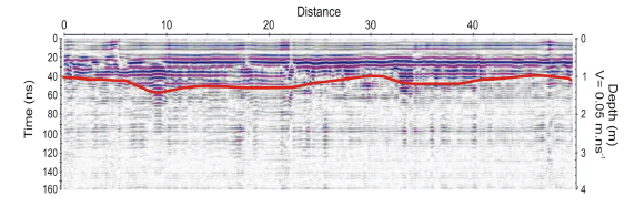
<body><![CDATA[<p><font size="2" face="Verdana, Arial, Helvetica, sans-serif">ERI profile    2 is 235 m long and runs transverse to the mine pond, starting and finishing in    the lateral containment dams. Two moderately high (10 to 45 ohm.m) resistivity areas located at the ends of the profile correspond    to the materials constituting the containment dams. Two different units can be    distinguished: a shallow one with low (5-20 ohm.m) resistivity values,    distributed homogeneously along the whole profile, that corresponds to the    materials infilling the pond; and a lower unit, with resistivity values ranging    from 20 to 145 ohm.m, associated to the mine pond’s substrate. The latter shows  some vertical steps and reaches a depth of about 12 m.</font></p>     <p><font size="2" face="Verdana, Arial, Helvetica, sans-serif">ERI profile    3 has the same length and trend that profile 2 but runs along the central part    of the mine pond. The observed structure is similar to profile 2: two main    units representing the infilling of the pond (5-20 ohm.m) and the metamorphic    materials of the substrate (lower unit with resistivity values ranging from 20    to 80 ohm.m). A discrete zone of moderately high (&gt; 60 ohm.m) resistivity    values located at the beginning of the profile still corresponds to the    materials of the containment dam. The mine pond’s substrate is subhorizontal  and is located at a maximum depth of about 12 m.</font></p>     <p><font size="2" face="Verdana, Arial, Helvetica, sans-serif">ERI profile    4 is 235 m long and runs transverse to profiles 1, 2 and 3, in order to obtain    the geometry of the mine pond’s substrate along its longitudinal axis. The    obtained results are quite similar to profile 1: a shallow unit reaching a    depth of about 2 m, located only in the first half of the profile (15-30    ohm.m); an intermediate unit homogeneously distributed along the whole profile    with low (5-15 ohm.m) resistivity values; and a lower, unit, corresponding to    the metamorphic material that defines the mine pond’s substrate, located at a  depth of about 12-13 m (30-100 ohm.m).</font></p>     <p><font size="2" face="Verdana, Arial, Helvetica, sans-serif">In order to    obtain more detail of the uppermost structure of the mine pond near ERI profile    1, a GPR survey of 12 profiles was carried out. After calibration using a    metallic rebar buried at known depth, a 0.05 m.ns<sup>-1</sup> mean EM waves    velocity was obtained. Considering that the infilling of the pond is quite    homogeneous, this velocity value can be adopted as constant in the entire pond.    Taking into account that the window time used is 160 ns, the depth of    investigation of about 4 m. This low velocity is related to the low resistivity    values of the materials that constitute the infilling of the mine pond. As a    result, the investigation depth is small and the attenuation of the EM waves is    high. In consequence, this method only provides information about the structure    of the first meters depth of the mine pond, proving less useful than the ERI    method. Therefore, only one radargram is shown (<a href="#fig03">Fig. 3</a>). Two main units have    been distinguished, reaching 0.5-1 m and 2-2.5 m depth respectively, showing a    strong attenuation of the     EM    waves. This is related to a progressive increase in water    content from 1 m depth downwards that causes attenuation of the energy of the EM waves. Thus, it could    be inferred that the shallow unit is constituted by low water content materials  whereas the deeper one is defined by high porosity, water saturated ones.</font></p>      <p align="center"><font size="2" face="Verdana, Arial, Helvetica, sans-serif"><b><a name="fig03"></a><img src="/img/revistas/dyna/v77n161/a13fig03.gif">    <br>   Figure   3.</b> GPR profile showing the boundary between the two main    units identified</font></p>  <font size="2" face="Verdana, Arial, Helvetica, sans-serif"><b>4.2 Mineralogy</b>    <br>  A    mineralogical composition made up of quartz and illite as main minerals, and    Na-Ca feldspar, chlorite-smectite and gypsum as accessory mineral phases, can    be defined from the X-ray Diffraction study in all the studied samples (<a href="#tab01">Table 1</a>).</font>      <p align="center"><font size="2" face="Verdana, Arial, Helvetica, sans-serif"><b><a name="tab01"></a>Table    1. </b> Semi-quantitative    mineralogical composition (wt%) of the studied samples</font>    <br>    <img src="/img/revistas/dyna/v77n161/a13tab01.gif"></p>     <p><font size="2" face="Verdana, Arial, Helvetica, sans-serif">This    mineralogical association can be found in the three sampling points carried    out. Dolomite has also been identified in trace amounts in SQ-2. From the    semi-quantitative analyses, it can be observed that quartz and clay minerals add up to 80-90% of total minerals.</font></p>     ]]></body>
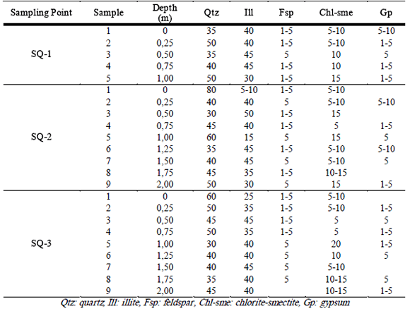
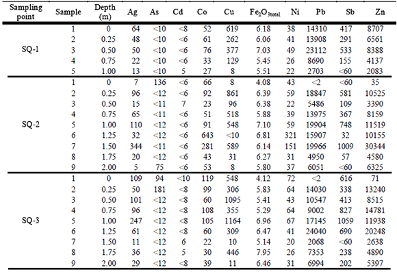
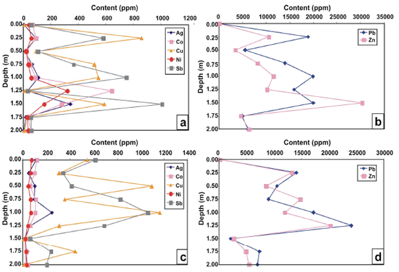
<body><![CDATA[<p><font size="2" face="Verdana, Arial, Helvetica, sans-serif">Chlorite-smectites    and gypsum have been identified in percentages of 5-15% and 10% respectively.    Gypsum is also present in all samples down to 1.5 m in depth, whereas feldspars    have been identified only in a minor proportion (5%). An un-expected feature of    all the samples is the absence of any sulphide of the mineralogical paragenesis    in these mine tailings. Minerals like galena, sphalerite, pyrite or chalcopyrite have not been identified by X-Ray Diffraction</font></p>     <p><font size="2" face="Verdana, Arial, Helvetica, sans-serif"><b>4.3 Geochemistry</b>    <br>  </font><font size="2" face="Verdana, Arial, Helvetica, sans-serif">Fe<sub>2</sub>O<sub>3total</sub> and trace element concentrations at different sampling depths are shown in    <a href="#tab02">Table 2</a>. All elements show significant contents and similar percentages in the    three sampling points. Elements displaying the highest concentrations are: Cu    (up to 1,164 ppm), Fe (up to 7.95 wt%), Pb (up to 24,040 ppm), Sb (up to 1,059    ppm) and Zn (up to 30,344 ppm). These are important  amounts in all cases, </font><font size="2" face="Verdana, Arial, Helvetica, sans-serif">although predictable due to the type of mineralization    that was exploited, which was fundamentally composed of galena (PbS),    sphalerite (ZnS), pyrite (FeS<sub>2</sub>), marcasite (FeS<sub>2</sub>) and    calchopyrite (CuFeS<sub>2</sub>) &#91;4&#93;. Pb and Zn show specially remarkable    contents. Ag, Co and Ni contents do not exceed 350, 643 and 321 ppm    respectively, and most of the samples show comparatively low contents of As&lt; 12 ppm and Cd&lt; 10 ppm. </font></p>     <p align="center"><font size="2" face="Verdana, Arial, Helvetica, sans-serif"><b><a name="tab02"></a>Table    2. </b> Contents in    trace elements of the samples from the San Quint&iacute;n tailing pond (values in ppm except for Fe<sub>2</sub>O<sub>3total </sub>&quot;in wt%&quot;)</font>    <br> <img src="/img/revistas/dyna/v77n161/a13tab02.gif"></p>     <p><font size="2" face="Verdana, Arial, Helvetica, sans-serif">All    analyzed elements show significant variations in their contents as a function    of depth. Such a variation defines a pattern with two depth levels showing    different metal contents: the highest ones occur between 0.25 and 1.5 m    (samples 2 to 7), whereas the lowest ones are located between 1.75 and 2.0 m    (samples 8 and 9) (Fig. 4). Within the first depth interval, preferential    concentration of Pb and Zn at 1.25 m depth is defined in SQ-3, whereas the same occurs in SQ-2 at 1.50 m depth (<a href="#tab02">Table 2</a>; <a href="#fig04">Fig. 4</a>).</font></p>     <p align="center"><font size="2" face="Verdana, Arial, Helvetica, sans-serif"><b><a name="fig04"></a><img src="/img/revistas/dyna/v77n161/a13fig04.gif">    <br>   Figure    4.</b> Distribution-with-depth profiles for: a) Ag, Co, Cu,    Ni and Sb from SQ-2 sampling point; b) Pb and Zn from SQ-2 sampling point; c)    Ag, Co, Cu, Ni and Sb from SQ-3 sampling point; d) Pb and Zn from SQ-3 sampling point</font></p>     <p>&nbsp;</p> <b><font size="3" face="Verdana, Arial, Helvetica, sans-serif">5. DISCUSSION AND CONCLUSIONS</font></b>     <p><font size="2" face="Verdana, Arial, Helvetica, sans-serif">An    integrated geophysical, geochemical and mineralogical study has allowed us to    obtain information about the geometry of the mine pond’s substrate, the    thickness of the infilling, its water content and its mineralogical  composition. </font></p>     ]]></body>
<body><![CDATA[<p><font size="2" face="Verdana, Arial, Helvetica, sans-serif">All this    information has revealed the internal structure of the mine pond and its    physico-chemical properties, which constitutes a valuable tool in order to    evaluate its potential as a pollution source and to design the reclamation measures to be adopted in the future.</font></p>     <p><font size="2" face="Verdana, Arial, Helvetica, sans-serif">The    geophysical survey has provided the geometry of the mine pond’s substrate that    reaches a maximum depth of about 12 m. In addition to this, two different units    have been defined for the infilling of the pond: a shallow one, laterally    discontinuous, corresponding to materials with low pore water content, and a    deeper unit, thicker than the first one and always present in all the studied    profiles, which is interpreted as water saturated materials defining the    infilling of the mine pond. As these materials produce a strong attenuation of    the GPR signal, the ERI technique reveals itself as the most useful method to  unravel the internal structure of this kind of mine deposits.</font></p>     <p><font size="2" face="Verdana, Arial, Helvetica, sans-serif">The    mineralogical composition obtained in this work is similar to the one described    in a previous one &#91;11&#93;. In both works, no metallic minerals, either from the    ore body or from subsequently treated dumps, were identified by X-Ray    Diffraction, due to the rework of the tailings made by the company who owned    the mine (SMMP) that drastically reduced the presence of this kind of minerals    in the mine ponds and the occurrence of sulphates as a weathering product of    the sulphides. It has to be taken into account that X-Ray Diffraction is only    able to detect the occurrence of mineral phases present in quantities greater    than 5 wt%. Thus, this would be the upper limit of concentration for each    mineral phase for the analyzed samples, representing an important amount of    metallic elements constituting a potential hazard. High contents in potentially    toxic elements, such as As, Cd, Cu, Pb, Sb and Zn, are clearly greater than the    maximum allowed values for agricultural soils defined in the European Community    Directive &#91;12&#93;. Some examples of concentration values greater than the allowed ones    are: 300 ppm for Pb and Zn, 140 ppm for Cu and 3 ppm for Cd. This fact is    frequent in all the mine ponds derived from sulphide extractions, constituting    deposits with a high degree of pollution, especially if accompanied by acid    mine drainage that can affect nearby water courses. Nevertheless, the mine pond    infilling presents pH values ranging from 6.2 to 8.1, which seems to indicate that no acid mine drainage is being generated in the San Quint&iacute;n’s mine pond.</font></p>     <p><font size="2" face="Verdana, Arial, Helvetica, sans-serif">Different    infilling levels of the mine pond exhibit different concentrations of metallic    elements. This can be explained by the development of more efficient extraction    techniques, together with the treatment of ores bodies with different    concentrations and, mainly, the rework of the tailings deposits. <a href="#fig04">Figure 4</a>  clearly shows that levels with the highest metallic elements concentrations are   located at 1.25-1.5 m depth, with a difference in topography between SQ-2 and   SQ-3 of 0.25 m, probably due to the different distance of these points to the original point of discharge.</font></p>     <p><font size="2" face="Verdana, Arial, Helvetica, sans-serif">Last but    not least, it can be highlighted that this abandoned mine group is visited by a    large number of tourists as it constitutes part of the     Don Quixote Route &#91;13&#93;. Although these    kinds of tourist initiatives are noteworthy in terms of geological heritage, it    is surprising that a previous characterization and reclamation work has not been afforded previously to the implementation of this new use.</font></p>      <p>&nbsp;</p>      <p><b><font size="3" face="Verdana, Arial, Helvetica, sans-serif">REFERENCES </font> </b></p>  <font size="2">      <!-- ref --><p><font face="Verdana, Arial, Helvetica, sans-serif"><b>&#91;1&#93;</b> HERN&Aacute;N, L., GONZ&Aacute;LEZ, L.M., ESPINOSA, A. Modelaci&oacute;n de elementos traza en el horizonte A de suelos, plancha 170 (V&eacute;lez, departamentos de Santander y Boyac&aacute;). DYNA, 156, 157-164, 2008.     &nbsp;&nbsp;&nbsp;&nbsp;&nbsp;&nbsp;&nbsp;&nbsp;[&#160;<a href="javascript:void(0);" onclick="javascript: window.open('/scielo.php?script=sci_nlinks&ref=000070&pid=S0012-7353201000010001300001&lng=','','width=640,height=500,resizable=yes,scrollbars=1,menubar=yes,');">Links</a>&#160;]<!-- end-ref --><!-- ref --><br>     <b>&#91;2&#93;</b> PALERO, F.J., BOTH, R.A., MANGAS, J., MART&Iacute;N-IZARD, A., REGUIL&Oacute;N, R. Metalog&eacute;nesis de los yacimientos de Pb-Zn de la regi&oacute;n del Valle de Alcudia (Sierra Morena Oriental). In: Recursos Minerales de Espa&ntilde;a (Eds. Garc&iacute;a Guinea, J. and Mart&iacute;nez Fr&iacute;as, J). CSIC. Madrid, 1027-1067, 1992.     &nbsp;&nbsp;&nbsp;&nbsp;&nbsp;&nbsp;&nbsp;&nbsp;[&#160;<a href="javascript:void(0);" onclick="javascript: window.open('/scielo.php?script=sci_nlinks&ref=000071&pid=S0012-7353201000010001300002&lng=','','width=640,height=500,resizable=yes,scrollbars=1,menubar=yes,');">Links</a>&#160;]<!-- end-ref --><!-- ref --><br>     <b>&#91;3&#93;</b> PALERO, F.J. Evoluci&oacute;n geotect&oacute;nica y yacimientos minerales de la regi&oacute;n del Valle de Alcudia (sector meridional de la Zona Centro Ib&eacute;rica). &#91;PhD Thesis&#93;</b> . University of Salamanca, 1991.       &nbsp;&nbsp;&nbsp;&nbsp;&nbsp;&nbsp;&nbsp;&nbsp;[&#160;<a href="javascript:void(0);" onclick="javascript: window.open('/scielo.php?script=sci_nlinks&ref=000072&pid=S0012-7353201000010001300003&lng=','','width=640,height=500,resizable=yes,scrollbars=1,menubar=yes,');">Links</a>&#160;]<!-- end-ref --><!-- ref --><br>     <b>&#91;4&#93;</b> TELFORD, W.M., GELDART, L.P., SHERIFF, R.E. Applied Geophysics. Cambridge University Press, 770 p., 1990.       &nbsp;&nbsp;&nbsp;&nbsp;&nbsp;&nbsp;&nbsp;&nbsp;[&#160;<a href="javascript:void(0);" onclick="javascript: window.open('/scielo.php?script=sci_nlinks&ref=000073&pid=S0012-7353201000010001300004&lng=','','width=640,height=500,resizable=yes,scrollbars=1,menubar=yes,');">Links</a>&#160;]<!-- end-ref --><!-- ref --><br>     <b>&#91;5&#93;</b> REYNOLDS, J.M. An Introduction to Applied and Environmental Geophyscis. Wiley, Chichester, 796 p., 1997.       &nbsp;&nbsp;&nbsp;&nbsp;&nbsp;&nbsp;&nbsp;&nbsp;[&#160;<a href="javascript:void(0);" onclick="javascript: window.open('/scielo.php?script=sci_nlinks&ref=000074&pid=S0012-7353201000010001300005&lng=','','width=640,height=500,resizable=yes,scrollbars=1,menubar=yes,');">Links</a>&#160;]<!-- end-ref --><!-- ref --><br>     <b>&#91;6&#93;</b> MART&Iacute;N-CRESPO, T., DE IGNACIO, C., G&Oacute;MEZ-ORTIZ, D., MART&Iacute;N-VEL&Aacute;ZQUEZ, S., LILLO-RAMOS, F.J. in press. Monitoring study of the mine pond reclamation of Mina Concepci&oacute;n, Iberian Pyrite Belt ( Spain ). Environmental Earth Sciences, 59, 1275-1284, 2010.     &nbsp;&nbsp;&nbsp;&nbsp;&nbsp;&nbsp;&nbsp;&nbsp;[&#160;<a href="javascript:void(0);" onclick="javascript: window.open('/scielo.php?script=sci_nlinks&ref=000075&pid=S0012-7353201000010001300006&lng=','','width=640,height=500,resizable=yes,scrollbars=1,menubar=yes,');">Links</a>&#160;]<!-- end-ref --><!-- ref --><br>     <b>&#91;7&#93;</b> G&Oacute;MEZ-ORTIZ, D., MART&Iacute;N-VEL&Aacute;ZQUEZ, S., MART&Iacute;N-CRESPO, T., DE IGNACIO-SANJOS&Eacute;, C., LILLO-RAMOS, F.J. in press. Application of Electrical Resistivity Tomography (ERT) to the environmental characterization of abandoned massive sulphide mine ponds (Iberia Pyrite belt, SW Spain). Near Surface Geophysics, 8, 65-74, 2010.     &nbsp;&nbsp;&nbsp;&nbsp;&nbsp;&nbsp;&nbsp;&nbsp;[&#160;<a href="javascript:void(0);" onclick="javascript: window.open('/scielo.php?script=sci_nlinks&ref=000076&pid=S0012-7353201000010001300007&lng=','','width=640,height=500,resizable=yes,scrollbars=1,menubar=yes,');">Links</a>&#160;]<!-- end-ref --><!-- ref --><br>     <b>&#91;8&#93;</b> MART&Iacute;NEZ-PAG&Aacute;N, P., FAZ-CANO, A., ARACIL, E., AROCENA, J.M. Electrical resistivity tomography revealed the spatial chemical properties of mine tailings ponds in the Sierra Minera ( SE Spain). Journal of Environmental & Engineering Geophysics, 14, 63-76, 2009.     &nbsp;&nbsp;&nbsp;&nbsp;&nbsp;&nbsp;&nbsp;&nbsp;[&#160;<a href="javascript:void(0);" onclick="javascript: window.open('/scielo.php?script=sci_nlinks&ref=000077&pid=S0012-7353201000010001300008&lng=','','width=640,height=500,resizable=yes,scrollbars=1,menubar=yes,');">Links</a>&#160;]<!-- end-ref --><!-- ref --><br>     <b>&#91;9&#93;</b> SASAKI, Y. Resolution of resistivity tomography inferred from numerical simulation. Geophysical Prospecting, 40, 453-464, 1992.       &nbsp;&nbsp;&nbsp;&nbsp;&nbsp;&nbsp;&nbsp;&nbsp;[&#160;<a href="javascript:void(0);" onclick="javascript: window.open('/scielo.php?script=sci_nlinks&ref=000078&pid=S0012-7353201000010001300009&lng=','','width=640,height=500,resizable=yes,scrollbars=1,menubar=yes,');">Links</a>&#160;]<!-- end-ref --><!-- ref --><br>     <b>&#91;10&#93;</b> DAVIS, J.L., ANNAN, A.P. Ground-penetrating radar for high-resolution mapping of soil and rock stratigraphy. Geophysical Prospecting, 37, 531-551, 1989.       &nbsp;&nbsp;&nbsp;&nbsp;&nbsp;&nbsp;&nbsp;&nbsp;[&#160;<a href="javascript:void(0);" onclick="javascript: window.open('/scielo.php?script=sci_nlinks&ref=000079&pid=S0012-7353201000010001300010&lng=','','width=640,height=500,resizable=yes,scrollbars=1,menubar=yes,');">Links</a>&#160;]<!-- end-ref --><!-- ref --><br>     <b>&#91;11&#93;</b> RODR&Iacute;GUEZ, L., RUIZ, E., ALONSO, J., RINC&Oacute;N, J. Heavy metal distribution and chemical speciation in tailings and soils around a Pb-Zn mine in Spain . Journal of Environmental Management, 90, 1106-1116, 2009.     &nbsp;&nbsp;&nbsp;&nbsp;&nbsp;&nbsp;&nbsp;&nbsp;[&#160;<a href="javascript:void(0);" onclick="javascript: window.open('/scielo.php?script=sci_nlinks&ref=000080&pid=S0012-7353201000010001300011&lng=','','width=640,height=500,resizable=yes,scrollbars=1,menubar=yes,');">Links</a>&#160;]<!-- end-ref --><!-- ref --><br>     <b>&#91;12&#93;</b> COUNCIL OF THE EUROPEAN COMMUNITIES. Off. J. Eur. Communities L181, 6–12, 1986.     &nbsp;&nbsp;&nbsp;&nbsp;&nbsp;&nbsp;&nbsp;&nbsp;[&#160;<a href="javascript:void(0);" onclick="javascript: window.open('/scielo.php?script=sci_nlinks&ref=000081&pid=S0012-7353201000010001300012&lng=','','width=640,height=500,resizable=yes,scrollbars=1,menubar=yes,');">Links</a>&#160;]<!-- end-ref --><!-- ref --><br>     <b>&#91;13&#93;</b> MART&Iacute;N CRESPO, T., G&Oacute;MEZ ORTIZ, D., MART&Iacute;N VEL&Aacute;ZQUEZ, S. Valor ecotur&iacute;stico de la mina de San Quint&iacute;n, Ruta de Don Quijote, Castilla-La Mancha. In: Congreso Nacional de Medio Ambiente 9, Workgroup “Rehabilitaci&oacute;n de Espacios Mineros”, 2008. </font>&nbsp;&nbsp;&nbsp;&nbsp;&nbsp;&nbsp;&nbsp;&nbsp;[&#160;<a href="javascript:void(0);" onclick="javascript: window.open('/scielo.php?script=sci_nlinks&ref=000082&pid=S0012-7353201000010001300013&lng=','','width=640,height=500,resizable=yes,scrollbars=1,menubar=yes,');">Links</a>&#160;]<!-- end-ref --> ]]></body><back>
<ref-list>
<ref id="B1">
<label>1</label><nlm-citation citation-type="journal">
<person-group person-group-type="author">
<name>
<surname><![CDATA[HERNÁN]]></surname>
<given-names><![CDATA[L.]]></given-names>
</name>
<name>
<surname><![CDATA[GONZÁLEZ]]></surname>
<given-names><![CDATA[L.M.]]></given-names>
</name>
<name>
<surname><![CDATA[ESPINOSA]]></surname>
<given-names><![CDATA[A.]]></given-names>
</name>
</person-group>
<article-title xml:lang="es"><![CDATA[Modelación de elementos traza en el horizonte A de suelos, plancha 170 (Vélez, departamentos de Santander y Boyacá)]]></article-title>
<source><![CDATA[DYNA, 156]]></source>
<year>2008</year>
<page-range>157-164</page-range></nlm-citation>
</ref>
<ref id="B2">
<label>2</label><nlm-citation citation-type="">
<person-group person-group-type="author">
<name>
<surname><![CDATA[PALERO]]></surname>
<given-names><![CDATA[F.J.]]></given-names>
</name>
<name>
<surname><![CDATA[BOTH]]></surname>
<given-names><![CDATA[R.A.]]></given-names>
</name>
<name>
<surname><![CDATA[MANGAS]]></surname>
<given-names><![CDATA[J.]]></given-names>
</name>
<name>
<surname><![CDATA[MARTÍN-IZARD]]></surname>
<given-names><![CDATA[A.]]></given-names>
</name>
<name>
<surname><![CDATA[REGUILÓN]]></surname>
<given-names><![CDATA[R.]]></given-names>
</name>
</person-group>
<article-title xml:lang="es"><![CDATA[Metalogénesis de los yacimientos de Pb-Zn de la región del Valle de Alcudia (Sierra Morena Oriental)]]></article-title>
<person-group person-group-type="editor">
<name>
<surname><![CDATA[García Guinea]]></surname>
<given-names><![CDATA[J.]]></given-names>
</name>
<name>
<surname><![CDATA[Martínez Frías]]></surname>
<given-names><![CDATA[J]]></given-names>
</name>
</person-group>
<source><![CDATA[Recursos Minerales de España]]></source>
<year>1992</year>
<page-range>1027-1067</page-range><publisher-loc><![CDATA[Madrid ]]></publisher-loc>
</nlm-citation>
</ref>
<ref id="B3">
<label>3</label><nlm-citation citation-type="">
<person-group person-group-type="author">
<name>
<surname><![CDATA[PALERO]]></surname>
<given-names><![CDATA[F.J.]]></given-names>
</name>
</person-group>
<source><![CDATA[Evolución geotectónica y yacimientos minerales de la región del Valle de Alcudia: sector meridional de la Zona Centro Ibérica]]></source>
<year></year>
</nlm-citation>
</ref>
<ref id="B4">
<label>4</label><nlm-citation citation-type="book">
<person-group person-group-type="author">
<name>
<surname><![CDATA[TELFORD]]></surname>
<given-names><![CDATA[W.M.]]></given-names>
</name>
<name>
<surname><![CDATA[GELDART]]></surname>
<given-names><![CDATA[L.P.]]></given-names>
</name>
<name>
<surname><![CDATA[SHERIFF]]></surname>
<given-names><![CDATA[R.E.]]></given-names>
</name>
</person-group>
<source><![CDATA[Applied Geophysics]]></source>
<year>1990</year>
<publisher-name><![CDATA[Cambridge University Press]]></publisher-name>
</nlm-citation>
</ref>
<ref id="B5">
<label>5</label><nlm-citation citation-type="book">
<person-group person-group-type="author">
<name>
<surname><![CDATA[REYNOLDS]]></surname>
<given-names><![CDATA[J.M.]]></given-names>
</name>
</person-group>
<source><![CDATA[An Introduction to Applied and Environmental Geophyscis]]></source>
<year>1997</year>
<publisher-name><![CDATA[Wiley]]></publisher-name>
</nlm-citation>
</ref>
<ref id="B6">
<label>6</label><nlm-citation citation-type="journal">
<person-group person-group-type="author">
<name>
<surname><![CDATA[MARTÍN-CRESPO]]></surname>
<given-names><![CDATA[T.]]></given-names>
</name>
<name>
<surname><![CDATA[DE IGNACIO]]></surname>
<given-names><![CDATA[C.]]></given-names>
</name>
<name>
<surname><![CDATA[GÓMEZ-ORTIZ]]></surname>
<given-names><![CDATA[D.]]></given-names>
</name>
<name>
<surname><![CDATA[MARTÍN-VELÁZQUEZ]]></surname>
<given-names><![CDATA[S.]]></given-names>
</name>
<name>
<surname><![CDATA[LILLO-RAMOS]]></surname>
<given-names><![CDATA[F.J.]]></given-names>
</name>
</person-group>
<article-title xml:lang="en"><![CDATA[Monitoring study of the mine pond reclamation of Mina Concepción, Iberian Pyrite Belt ( Spain )]]></article-title>
<source><![CDATA[Environmental Earth Sciences]]></source>
<year>2010</year>
<volume>59</volume>
<page-range>1275-1284</page-range></nlm-citation>
</ref>
<ref id="B7">
<label>7</label><nlm-citation citation-type="journal">
<person-group person-group-type="author">
<name>
<surname><![CDATA[GÓMEZ-ORTIZ]]></surname>
<given-names><![CDATA[D.]]></given-names>
</name>
<name>
<surname><![CDATA[MARTÍN-VELÁZQUEZ]]></surname>
<given-names><![CDATA[S.]]></given-names>
</name>
<name>
<surname><![CDATA[MARTÍN-CRESPO]]></surname>
<given-names><![CDATA[T.]]></given-names>
</name>
<name>
<surname><![CDATA[DE IGNACIO-SANJOSÉ]]></surname>
<given-names><![CDATA[C.]]></given-names>
</name>
<name>
<surname><![CDATA[LILLO-RAMOS]]></surname>
<given-names><![CDATA[F.J.]]></given-names>
</name>
</person-group>
<article-title xml:lang="en"><![CDATA[Application of Electrical Resistivity Tomography (ERT) to the environmental characterization of abandoned massive sulphide mine ponds (Iberia Pyrite belt, SW Spain)]]></article-title>
<source><![CDATA[Near Surface Geophysics]]></source>
<year>2010</year>
<volume>8</volume>
<page-range>65-74</page-range></nlm-citation>
</ref>
<ref id="B8">
<label>8</label><nlm-citation citation-type="journal">
<person-group person-group-type="author">
<name>
<surname><![CDATA[MARTÍNEZ-PAGÁN]]></surname>
<given-names><![CDATA[P.]]></given-names>
</name>
<name>
<surname><![CDATA[FAZ-CANO]]></surname>
<given-names><![CDATA[A.]]></given-names>
</name>
<name>
<surname><![CDATA[ARACIL]]></surname>
<given-names><![CDATA[E.]]></given-names>
</name>
<name>
<surname><![CDATA[AROCENA]]></surname>
<given-names><![CDATA[J.M.]]></given-names>
</name>
</person-group>
<article-title xml:lang="en"><![CDATA[Electrical resistivity tomography revealed the spatial chemical properties of mine tailings ponds in the Sierra Minera ( SE Spain)]]></article-title>
<source><![CDATA[Journal of Environmental & Engineering Geophysics]]></source>
<year>2009</year>
<volume>14</volume>
<page-range>63-76</page-range></nlm-citation>
</ref>
<ref id="B9">
<label>9</label><nlm-citation citation-type="journal">
<person-group person-group-type="author">
<name>
<surname><![CDATA[SASAKI]]></surname>
<given-names><![CDATA[Y.]]></given-names>
</name>
</person-group>
<article-title xml:lang="en"><![CDATA[Resolution of resistivity tomography inferred from numerical simulation]]></article-title>
<source><![CDATA[Geophysical Prospecting]]></source>
<year>1992</year>
<volume>40</volume>
<page-range>453-464</page-range></nlm-citation>
</ref>
<ref id="B10">
<label>10</label><nlm-citation citation-type="journal">
<person-group person-group-type="author">
<name>
<surname><![CDATA[DAVIS]]></surname>
<given-names><![CDATA[J.L.]]></given-names>
</name>
<name>
<surname><![CDATA[ANNAN]]></surname>
<given-names><![CDATA[A.P.]]></given-names>
</name>
</person-group>
<article-title xml:lang="en"><![CDATA[Ground-penetrating radar for high-resolution mapping of soil and rock stratigraphy]]></article-title>
<source><![CDATA[Geophysical Prospecting]]></source>
<year>1989</year>
<volume>37</volume>
<page-range>531-551</page-range></nlm-citation>
</ref>
<ref id="B11">
<label>11</label><nlm-citation citation-type="journal">
<person-group person-group-type="author">
<name>
<surname><![CDATA[RODRÍGUEZ]]></surname>
<given-names><![CDATA[L.]]></given-names>
</name>
<name>
<surname><![CDATA[RUIZ]]></surname>
<given-names><![CDATA[E.]]></given-names>
</name>
<name>
<surname><![CDATA[ALONSO]]></surname>
<given-names><![CDATA[J.]]></given-names>
</name>
<name>
<surname><![CDATA[RINCÓN]]></surname>
<given-names><![CDATA[J.]]></given-names>
</name>
</person-group>
<article-title xml:lang="en"><![CDATA[Heavy metal distribution and chemical speciation in tailings and soils around a Pb-Zn mine in Spain]]></article-title>
<source><![CDATA[Journal of Environmental Management]]></source>
<year>2009</year>
<volume>90</volume>
<page-range>1106-1116</page-range></nlm-citation>
</ref>
<ref id="B12">
<label>12</label><nlm-citation citation-type="">
<collab>COUNCIL OF THE EUROPEAN COMMUNITIES</collab>
<article-title xml:lang="en"><![CDATA[Off. J. Eur. Communities L181]]></article-title>
<source><![CDATA[]]></source>
<year>1986</year>
<page-range>6-12</page-range></nlm-citation>
</ref>
<ref id="B13">
<label>13</label><nlm-citation citation-type="confpro">
<person-group person-group-type="author">
<name>
<surname><![CDATA[MARTÍN CRESPO]]></surname>
<given-names><![CDATA[T.]]></given-names>
</name>
<name>
<surname><![CDATA[GÓMEZ ORTIZ]]></surname>
<given-names><![CDATA[D.]]></given-names>
</name>
<name>
<surname><![CDATA[MARTÍN VELÁZQUEZ]]></surname>
<given-names><![CDATA[S.]]></given-names>
</name>
</person-group>
<article-title xml:lang="es"><![CDATA[Valor ecoturístico de la mina de San Quintín, Ruta de Don Quijote, Castilla-La Mancha]]></article-title>
<source><![CDATA[]]></source>
<year></year>
<conf-name><![CDATA[9 Congreso Nacional de Medio Ambiente]]></conf-name>
<conf-date>2008</conf-date>
<conf-loc> </conf-loc>
</nlm-citation>
</ref>
</ref-list>
</back>
</article>