<?xml version="1.0" encoding="ISO-8859-1"?><article xmlns:mml="http://www.w3.org/1998/Math/MathML" xmlns:xlink="http://www.w3.org/1999/xlink" xmlns:xsi="http://www.w3.org/2001/XMLSchema-instance">
<front>
<journal-meta>
<journal-id>0012-7353</journal-id>
<journal-title><![CDATA[DYNA]]></journal-title>
<abbrev-journal-title><![CDATA[Dyna rev.fac.nac.minas]]></abbrev-journal-title>
<issn>0012-7353</issn>
<publisher>
<publisher-name><![CDATA[Universidad Nacional de Colombia]]></publisher-name>
</publisher>
</journal-meta>
<article-meta>
<article-id>S0012-73532013000200016</article-id>
<title-group>
<article-title xml:lang="en"><![CDATA[WEB-BASED SPATIAL DATA INFRASTRUCTURE: A SOLUTION FOR THE SUSTAINABLE MANAGEMENT OF THEMATIC INFORMATION SUPPORTED BY AERIAL ORTHOPHOTOGRAPHY]]></article-title>
<article-title xml:lang="es"><![CDATA[INFRAESTRUCTURA WEB DE DATOS ESPACIALES: UNA SOLUCIÓN PARA LA GESTIÓN SOSTENIBLE DE INFORMACIÓN TEMÁTICA APOYADA EN ORTOFOTOGRAFÍA AÉREA]]></article-title>
</title-group>
<contrib-group>
<contrib contrib-type="author">
<name>
<surname><![CDATA[HERNANDEZ-LÓPEZ]]></surname>
<given-names><![CDATA[DAVID]]></given-names>
</name>
<xref ref-type="aff" rid="A01"/>
</contrib>
<contrib contrib-type="author">
<name>
<surname><![CDATA[FELIPE-GARCÍA]]></surname>
<given-names><![CDATA[BEATRIZ]]></given-names>
</name>
<xref ref-type="aff" rid="A02"/>
</contrib>
<contrib contrib-type="author">
<name>
<surname><![CDATA[GONZÁLEZ-AGUILERA]]></surname>
<given-names><![CDATA[DIEGO]]></given-names>
</name>
<xref ref-type="aff" rid="A03"/>
</contrib>
<contrib contrib-type="author">
<name>
<surname><![CDATA[ARIAS-PÉREZ]]></surname>
<given-names><![CDATA[BENJAMÍN]]></given-names>
</name>
<xref ref-type="aff" rid="A04"/>
</contrib>
</contrib-group>
<aff id="A01">
<institution><![CDATA[,Universidad de Castilla-La Mancha Instituto de Desarrollo Regional ]]></institution>
<addr-line><![CDATA[Albacete ]]></addr-line>
</aff>
<aff id="A02">
<institution><![CDATA[,Universidad de Castilla-La Mancha Instituto de Desarrollo Regional ]]></institution>
<addr-line><![CDATA[Albacete ]]></addr-line>
</aff>
<aff id="A03">
<institution><![CDATA[,Universidad de Salamanca Departamento de Ingeniería Cartográfica y del Terreno ]]></institution>
<addr-line><![CDATA[Ávila ]]></addr-line>
</aff>
<aff id="A04">
<institution><![CDATA[,Universidad de Salamanca Departamento de Ingeniería Cartográfica y del Terreno ]]></institution>
<addr-line><![CDATA[Ávila ]]></addr-line>
</aff>
<pub-date pub-type="pub">
<day>00</day>
<month>04</month>
<year>2013</year>
</pub-date>
<pub-date pub-type="epub">
<day>00</day>
<month>04</month>
<year>2013</year>
</pub-date>
<volume>80</volume>
<numero>178</numero>
<fpage>123</fpage>
<lpage>131</lpage>
<copyright-statement/>
<copyright-year/>
<self-uri xlink:href="http://www.scielo.org.co/scielo.php?script=sci_arttext&amp;pid=S0012-73532013000200016&amp;lng=en&amp;nrm=iso"></self-uri><self-uri xlink:href="http://www.scielo.org.co/scielo.php?script=sci_abstract&amp;pid=S0012-73532013000200016&amp;lng=en&amp;nrm=iso"></self-uri><self-uri xlink:href="http://www.scielo.org.co/scielo.php?script=sci_pdf&amp;pid=S0012-73532013000200016&amp;lng=en&amp;nrm=iso"></self-uri><abstract abstract-type="short" xml:lang="en"><p><![CDATA[Under the framework of the Spanish National Plan for Aerial Orthophotography in Castilla-La Mancha, a web-based spatial data infrastructure has been developed that allows both the sustainable management of spatial and thematic information and efficient quality control of orthophoto production. The dissemination of thematic cartographic information by means of false-color infrared images and their physical parameters (reflectance and radiance) could allow its use in applications such as the extraction of biophysical parameters, forest coverage evolution and vegetative analysis of species. For wide accessibility, a geoportal that offers all the information related to the project and based on spatial data infrastructure technology has been created (http://ide.jccm.es/pnoa) that incorporates web map services.]]></p></abstract>
<abstract abstract-type="short" xml:lang="es"><p><![CDATA[En el marco de ejecución del Plan Nacional Español de Ortofotografía Aérea de Castilla-La Mancha se ha desarrollado una infraestructura web de datos espaciales que permite la gestión sostenible de información espacial y temática junto con el cumplimiento del control de calidad de producción de ortofoto de una forma eficiente. En concreto, se ha llevado a cabo una difusión de información cartográfica temática por medio de imágenes infrarrojas y sus parámetros físicos (reflectancia y radiancia), los cuales permiten su explotación en aplicaciones relacionadas con la extracción de parámetros físicos, evolución de la cubierta forestal y análisis agronómico de especies vegetales. Dado que se ha perseguido en todo momento la mayor transparencia posible, se ha creado un geoportal que ofrece toda la información de interés relativa al proyecto basándose en tecnologías de infraestructura de datos espaciales (http://ide.jccm.es/pnoa), incorporando servicios web de mapas.]]></p></abstract>
<kwd-group>
<kwd lng="en"><![CDATA[Photogrammetric flight]]></kwd>
<kwd lng="en"><![CDATA[False-color infrared images]]></kwd>
<kwd lng="en"><![CDATA[Thematic information]]></kwd>
<kwd lng="en"><![CDATA[Geographical Information System]]></kwd>
<kwd lng="en"><![CDATA[Quality Control]]></kwd>
<kwd lng="en"><![CDATA[Web Map Service]]></kwd>
<kwd lng="es"><![CDATA[Vuelo fotogramétrico]]></kwd>
<kwd lng="es"><![CDATA[Imágenes infrarrojo falso color]]></kwd>
<kwd lng="es"><![CDATA[Información temática]]></kwd>
<kwd lng="es"><![CDATA[Sistemas de Información Geográfica]]></kwd>
<kwd lng="es"><![CDATA[Control de Calidad]]></kwd>
<kwd lng="es"><![CDATA[Servicios Web de Mapas]]></kwd>
</kwd-group>
</article-meta>
</front><body><![CDATA[ <p align="center"><font size="4" face="Verdana, Arial, Helvetica, sans-serif"><b>WEB-BASED SPATIAL DATA  INFRASTRUCTURE: A SOLUTION FOR THE SUSTAINABLE MANAGEMENT OF THEMATIC  INFORMATION SUPPORTED BY AERIAL ORTHOPHOTOGRAPHY</b></font></p>     <p align="center"><i><font size="3"><b><font face="Verdana, Arial, Helvetica, sans-serif">INFRAESTRUCTURA WEB DE DATOS ESPACIALES: UNA SOLUCI&Oacute;N PARA LA  GESTI&Oacute;N SOSTENIBLE DE INFORMACI&Oacute;N TEM&Aacute;TICA APOYADA EN ORTOFOTOGRAF&Iacute;A A&Eacute;REA </font></b></font></i></p>     <p align="center">&nbsp;</p>     <p align="center"><font size="2" face="Verdana, Arial, Helvetica, sans-serif"><b>DAVID HERNANDEZ-L&Oacute;PEZ</b>    <br>   <i>Ph.D., Universidad de Castilla-La Mancha, Instituto de Desarrollo Regional, Albacete, <a href="mailto:david.hernandez@uclm.es">david.hernandez@uclm.es</a></i></font></p>     <p align="center"><font size="2" face="Verdana, Arial, Helvetica, sans-serif"><b>BEATRIZ FELIPE-GARC&Iacute;A</b>    <br>   <i>Ph.D., Universidad de Castilla-La Mancha, Instituto de Desarrollo Regional, Albacete, <a href="mailto:beatriz.felipe@uclm.es">beatriz.felipe@uclm.es</a></i></font></p>     <p align="center"><font size="2" face="Verdana, Arial, Helvetica, sans-serif"><b>DIEGO GONZ&Aacute;LEZ-AGUILERA</b>    <br>   <i>Ph.D., Universidad de Salamanca, Departamento de Ingenier&iacute;a Cartogr&aacute;fica y del Terreno, &Aacute;vila, <a href="mailto:daguilera@usal.es">daguilera@usal.es</a></i></font></p>     <p align="center"><font size="2" face="Verdana, Arial, Helvetica, sans-serif"><b>BENJAM&Iacute;N ARIAS-P&Eacute;REZ</b>    ]]></body>
<body><![CDATA[<br>   <i>Ph.D., Universidad de Salamanca, Departamento de Ingenier&iacute;a Cartogr&aacute;fica y del Terreno, &Aacute;vila, <a href="mailto:benja@usal.es">benja@usal.es</a></i></font></p>     <p align="center">&nbsp;</p>     <p align="center"><font size="2" face="Verdana, Arial, Helvetica, sans-serif"><b>Received for review February 22<sup>th</sup>, 2012, accepted October 22<sup>th</sup>, 2012, final version November, 19<sup>th</sup>, 2012</b></font></p>     <p align="center">&nbsp;</p> <hr>     <p><font size="2" face="Verdana, Arial, Helvetica, sans-serif"><b>ABSTRACT:</b> Under the framework of the Spanish National Plan for Aerial Orthophotography in Castilla-La Mancha, a web-based spatial data infrastructure has been developed that allows both the sustainable management of spatial and thematic information and efficient quality control of orthophoto production. The dissemination of thematic cartographic information by means of false-color infrared images and their physical parameters (reflectance and radiance) could allow its use in applications such as the extraction of biophysical parameters, forest coverage evolution and vegetative analysis of species. For wide accessibility, a geoportal that offers all the information related to the project and based on spatial data infrastructure technology has been created (<a href="http://ide.jccm.es/pnoa" target="referencia">http://ide.jccm.es/pnoa</a>) that incorporates web map services.</font></p>     <p><font size="2" face="Verdana, Arial, Helvetica, sans-serif"><b>KEYWORDS:</b> Photogrammetric flight; False-color infrared images; Thematic information; Geographical Information System; Quality Control, Web Map Service</font></p>     <p><font size="2" face="Verdana, Arial, Helvetica, sans-serif"><b>RESUMEN:</b> En el marco de ejecuci&oacute;n del Plan Nacional Espa&ntilde;ol de Ortofotograf&iacute;a A&eacute;rea de Castilla-La Mancha se ha desarrollado una infraestructura web de datos espaciales que permite la gesti&oacute;n sostenible de informaci&oacute;n espacial y tem&aacute;tica junto con el cumplimiento del control de calidad de producci&oacute;n de ortofoto de una forma eficiente. En concreto, se ha llevado a cabo una difusi&oacute;n de informaci&oacute;n cartogr&aacute;fica tem&aacute;tica por medio de im&aacute;genes infrarrojas y sus par&aacute;metros f&iacute;sicos (reflectancia y radiancia), los cuales permiten su explotaci&oacute;n en aplicaciones relacionadas con la extracci&oacute;n de par&aacute;metros f&iacute;sicos, evoluci&oacute;n de la cubierta forestal y an&aacute;lisis agron&oacute;mico de especies vegetales. Dado que se ha perseguido en todo momento la mayor transparencia posible, se ha creado un geoportal que ofrece toda la informaci&oacute;n de inter&eacute;s relativa al proyecto bas&aacute;ndose en tecnolog&iacute;as de infraestructura de datos espaciales (<a href="http://ide.jccm.es/pnoa" target="referencia">http://ide.jccm.es/pnoa</a>), incorporando servicios web de mapas.</font></p>     <p><font size="2" face="Verdana, Arial, Helvetica, sans-serif"><b>PALABRAS CLAVE:</b> Vuelo fotogram&eacute;trico; Im&aacute;genes infrarrojo falso color; Informaci&oacute;n tem&aacute;tica; Sistemas de Informaci&oacute;n Geogr&aacute;fica; Control de Calidad, Servicios Web de Mapas.</font></p> <hr>     <p>&nbsp;</p>     <p><font size="3" face="Verdana, Arial, Helvetica, sans-serif"><b>1.  INTRODUCTION</b></font></p>     ]]></body>
<body><![CDATA[<p><font size="2" face="Verdana, Arial, Helvetica, sans-serif">The distribution of geoinformation on the web has become increasingly important in an information society, particularly for cartographic production, local planning and public/private participation &#91;1-4&#93;. To disseminate geoinformation through Spatial Data Infrastructure (SDI) and to support the well-known concept of &quot;collect data once, use it many times&quot; it is important to generate information automatically. To this end, web-based SDI, which can be defined as a software component that provides geospatial applications functionality through a web-accessible interface in a programming language- and platform-independent manner &#91;5&#93;, constitutes a possible and efficient solution to derive spatial and thematic information. Major initiatives in Geographical Information System (GIS) interoperability are solving new problems by defining sets of standards and by specifying development interfaces &#91;6&#93;. With the aim of providing geoinformation automatically, two important types of geoprocesses should be considered: generalization &#91;7&#93; and schema transformation &#91;8,9&#93;. While the schema transformation processes transform the thematic characteristics of geodata, the generalization processes transform the spatial properties. In this sense, web-based SDI has made it possible to combine both concepts into a web-based process, reducing the cost of data maintenance and capture &#91;10&#93;. A distributed geospatial data storage and processing framework for large-scale web application is fundamental &#91;11,12&#93;. Today's geoportals are focusing on interoperability through the implementation of standards for discovery and the use of geographic data and services. Some interesting implementations that are looking for the interoperation of multi-source environments include the following: remote sensing &#91;13&#93;, topography &#91;14&#93;, thematic cartography &#91;15&#93;, cropland &#91;16&#93;, urban and environmental management &#91;17&#93; and emission inventory &#91;18&#93;. Therefore, based on actual successful experiences that have led to the development of community-based portals, possible strategies for the development of the next generation of geoportals are shown &#91;19&#93;.</font></p>     <p><font size="2" face="Verdana, Arial, Helvetica, sans-serif">Under this framework, the Spanish National Plan for Aerial Orthophotography in Castilla-La Mancha (PNOA) is one of the most important projects included in the General Spanish National Plan for Territory Observation &#91;20&#93;. This plan is divided in two different phases: (i) capturing and processing the necessary images from aircraft and satellite and (ii) data extraction and dissemination. PNOA is a project co-financed by the Central Government and the Autonomous Regions. In the region of Castilla-La Mancha the agents that take part through agreements of collaboration between civil services, are the following: the Board of Communities of Castilla-La Mancha (Statistical Institute of Castilla-La Mancha) responsible for management at regional level, mainly administrative tasks; the National Geographic project manager at the national level; and the Regional Development Institute at the University of Castilla-La Mancha, which carries out technical management and regional quality control. The company that carries out the photogrammetric project is Tragsatec via commissioned management with the regional administration, so the National Geographical Institute (IGN) staff will be in charge of developing the national-autonomic control. To date, only one aerial photogrammetric flight covering the entire region has been performed. The flight utilized the Digital Mapping Camera (DMC) and was carried out by the Cartographic Institute of Catalu&ntilde;a.</font></p>     <p><font size="2" face="Verdana, Arial, Helvetica, sans-serif"><b>1.1.  Goals</b>    <br>   First, this project analyzes the importance of exploiting thematic (radiometric) information using false-color infrared images. One of the main challenges of photogrammetry is the automatic extraction of physical measurements by means of reflectance and radiance images. In this way, and similarly to remote sensing images, several approaches and analyses such as the extraction of biophysical parameters, forest coverage evolution and vegetative analysis of species, can be extrapolated. For this purpose, an exhaustive analysis is made of the physical elements present in the area of study in the acquisition phase, of which atmosphere, solar illumination, observation geometry and terrain information are mandatory. </font></p>     <p><font size="2" face="Verdana, Arial, Helvetica, sans-serif">Second is monitoring the status of the project. It is essential to know the actual project status together with its evolution. Questions such as what area of the territory has been expanded , how has the vegetal or forest surface evolved, or how many sheets of the digital elevation model or orthophoto have been made are essential. In this line of work, time is a vital factor because the information varies very quickly. Thus, to have valid monitoring, the information must be constantly updated rapidly and should indicate the date of update. Project monitoring involves reporting the rates of production of the company and the dynamics of quality control. In particular, these projects are made up of several steps of production and quality control which are performed in a sequential fashion and require a considerable workload. That is, the next step cannot be performed until the corresponding quality control step has been validated. For instance, the digital terrain model cannot be generated until the aerotriangulation has not been validated. Therefore, a delay in the quality control step directly affects the production step and vice versa. Because the project is in constant motion, an essential condition of the designed system is to allow rapid updating of information with minimal effort with an easy way to incorporate new content.</font></p>     <p><font size="2" face="Verdana, Arial, Helvetica, sans-serif">Third is the development and implementation of a data model that allows the management of the project in an optimal way and which is scalable according to the needs of the project. To this end, the processes presented are developed using the Open Geospatial Consortium (OGC) Web Processing Service (WPS), &#91;21&#93;, which is OGC's interface specifications for Geoprocessing Services.</font></p>     <p><font size="2" face="Verdana, Arial, Helvetica, sans-serif">Last but not least, is the publishing of the results: from the main derived metric and thematic cartographic products to those reports related to the quality control protocols undertaken by the regional technical team. Special emphasis is placed on exploiting the four multispectral bands provided by the DMC digital camera, to obtain thematic information that can be contrasted based on its spatial and temporal resolution. To this end, a radiometric calibration of the camera &#91;22&#93; is performed with the aim of passing from digital levels to real physical magnitudes.</font></p>     <p><font size="2" face="Verdana, Arial, Helvetica, sans-serif">This paper presents a solution for the sustainable thematic management of thematic information and quality control of orthophoto production using a web-based SDI. After this introduction, Section 2 outlines the SDI architecture developed together with its conceptual model; Section 3 describes the project monitoring in each of the phases of production; Section 4 presents the quality control performed to meet the technical specifications of the project; and Section 5 describes the exploitation of thematic information based on reflectance and radiance images. A final section is devoted to the concluding remarks and future perspectives.</font></p>     <p>&nbsp;</p>     <p><font size="3" face="Verdana, Arial, Helvetica, sans-serif"><b>2. SPATIAL DATA INFRASTRUCTURE ARCHITECTURE</b></font></p>     ]]></body>
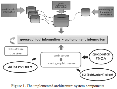
<body><![CDATA[<p><b><font size="2" face="Verdana, Arial, Helvetica, sans-serif">2.1.  System components</font></b><font size="2" face="Verdana, Arial, Helvetica, sans-serif">    <br>   The system is based on the conventional model of three layers. The primary level is the data that can be arranged in different formats. At the intermediate level are the application servers and interfaces that allow the third level, comprising the final user, to access the data in a controlled manner.</font></p>     <p><font size="2" face="Verdana, Arial, Helvetica, sans-serif">The following scheme (<a href="#fig01">Fig. 1</a>) briefly outlines the set of components that comprise the system architecture.</font></p>     <p align="center"><font size="2" face="Verdana, Arial, Helvetica, sans-serif"><a name="fig01"></a></font><img src="/img/revistas/dyna/v80n178/v80n178a16fig01.gif"></p>     <p><font size="2" face="Verdana, Arial, Helvetica, sans-serif">In the designed model, the basis is a database with a spatial component that integrates purely geographical and alphanumeric information that remains interrelated at all times. Basic information comes mainly from the following sources:</font></p> <ul>   <li ><font size="2" face="Verdana, Arial, Helvetica, sans-serif">Information on the results of quality control, which together constitute the largest volume of data.</font></li>   <li ><font size="2" face="Verdana, Arial, Helvetica, sans-serif">Information about the monitoring of the project, whose main characteristic is its constant evolution and constant change, requiring immediate updating of data.</font></li>   <li ><font size="2" face="Verdana, Arial, Helvetica, sans-serif">Basic reference information, whose presence is essential for the management of the geographic information, such as mapping grids and administrative boundaries.</font></li>     </ul>     <p><font size="2" face="Verdana, Arial, Helvetica, sans-serif">Another essential component is a web server application that enables communication through <i>http protocol</i>. In this case, the Apache server (<a href="http://www.apache.org/" target="referencia">http://www.apache.org/</a>) is used. A mapping server called <i>Mapserver</i> is installed on this application to manage and visualize geographic information. These two elements are essential, as they allow access to the information base through various types of requests.</font></p>     <p><font size="2" face="Verdana, Arial, Helvetica, sans-serif">Finally, it is essential to discuss the role of the user as a part of the system component. Depending on the method of accessing the published information, different types of customers can be established:</font></p> <ul>   <li ><font size="2" face="Verdana, Arial, Helvetica, sans-serif">The geoportal PNOA, designed for this purpose, is the client that is always connected and constantly evolving.</font></li>   <li ><font size="2" face="Verdana, Arial, Helvetica, sans-serif">Any SDI (lightweight) client, who through other viewers can connect via Web Map Service (WMS) to implement services in a manner analogous to the PNOA geoportal.</font></li>   <li ><font size="2" face="Verdana, Arial, Helvetica, sans-serif">Any SDI (heavy) client that can access data via WMS through local applications.</font></li>   <li class="DYNA-normal para-style-override-8"><font size="2" face="Verdana, Arial, Helvetica, sans-serif">A registered Castilla-La Mancha customer who has permission to enter directly into the PNOA database.</font></li>     </ul>     <p><font size="2" face="Verdana, Arial, Helvetica, sans-serif"><b>2.2.  Conceptual model</b>    ]]></body>
<body><![CDATA[<br>   Among the most important conditions for the implemented infrastructure is that the conceptual model must be agile with information management, updating and adding new elements &#91;23,24&#93;. </font></p>     <p><font size="2" face="Verdana, Arial, Helvetica, sans-serif">The region of Castilla-La Mancha is divided into blocks of geographic information (Block_GI) that will be, in general, the common unit of work for all phases of this project. To this end, the following structure is defined:</font></p> <ul>   <li ><font size="2" face="Verdana, Arial, Helvetica, sans-serif">Block_PF_Plan: Block of the photogrammetric flight in the planning phase, which is composed of an aggregation of images (Image_PF_Planned).</font></li>   <li ><font size="2" face="Verdana, Arial, Helvetica, sans-serif">Block_PF_Execution: Block of the photogrammetric flight at the stage of execution that is constituted by an aggregation of images (Image_PF_Executed).</font></li>   <li ><font size="2" face="Verdana, Arial, Helvetica, sans-serif">Block_CCP: Block of processing of control and check points.</font></li>   <li ><font size="2" face="Verdana, Arial, Helvetica, sans-serif">Block_AT: Block of aerotriangulation calculation.</font></li>   <li ><font size="2" face="Verdana, Arial, Helvetica, sans-serif">Block _DEM: Block of digital elevation models.</font></li>   <li class="DYNA-normal para-style-override-8"><font size="2" face="Verdana, Arial, Helvetica, sans-serif">Block_ORT: Block of orthophotos</font></li>     </ul>     <p><font size="2" face="Verdana, Arial, Helvetica, sans-serif">Block _GI is formed by an aggregation of Geographic Information Units in the form of a map sheet (Sheet _GI), which may belong to the series 1:50.000, 1:25.000 and 1:10.000. </font></p>     <p><font size="2" face="Verdana, Arial, Helvetica, sans-serif">Each unit of geographic information is associated with, in addition to the spatial information, a temporal component which is included in the Sheet_GI, that allows us to know the current state. In this project, the following states of the model are of vital importance:</font></p> <ul>   <li ><font size="2" face="Verdana, Arial, Helvetica, sans-serif">State _Production: Reflects the current state of the company executing the project.</font></li>   <li ><font size="2" face="Verdana, Arial, Helvetica, sans-serif">State _CC: Reflects the current state within the process of regional quality control.</font></li>   <li class="DYNA-normal para-style-override-8"><font size="2" face="Verdana, Arial, Helvetica, sans-serif">State _Diffusion: Reflects the current state of the process of distribution.</font></li>     </ul>     <p>&nbsp;</p>     <p><font size="3" face="Verdana, Arial, Helvetica, sans-serif"><b>3. PROJECT MONITORING</b></font></p>     <p><font size="2" face="Verdana, Arial, Helvetica, sans-serif">Due to the dynamics of the project, this type of information varies almost daily. The geoportal provides an overview of the project, which reflects both the production work performed by the contractor and the changes in the quality control process. An established categorization divides the project into the following phases of production:</font></p> <ul>   <li ><font size="2" face="Verdana, Arial, Helvetica, sans-serif">Photogrammetric flight</font></li>   <li ><font size="2" face="Verdana, Arial, Helvetica, sans-serif">Control and check points</font></li>   <li ><font size="2" face="Verdana, Arial, Helvetica, sans-serif">Aerial Triangulation</font></li>   <li ><font size="2" face="Verdana, Arial, Helvetica, sans-serif">Digital Elevation Model</font></li>   <li ><font size="2" face="Verdana, Arial, Helvetica, sans-serif">Orthophoto</font></li>     </ul>     ]]></body>
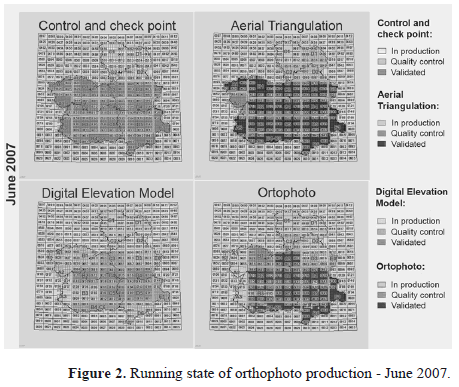
<body><![CDATA[<p><font size="2" face="Verdana, Arial, Helvetica, sans-serif">In each one of these phases, the state of each map sheet is shown. The states that have been defined for the geoportal must be simple and not show ambiguities, so the following states have been established:</font></p> <ul>   <li ><font size="2" face="Verdana, Arial, Helvetica, sans-serif">In production: Located in the period of execution by the company, in this case Tragsatec. If we consider the temporal parameter of the process, a product can be found in this state due to two situations:</font></li>     </ul> <ul>   <ul>         <li><font size="2" face="Verdana, Arial, Helvetica, sans-serif">The product has not yet been delivered because it has not completed the task of realization or production.</font></li>         <li><font size="2" face="Verdana, Arial, Helvetica, sans-serif"> The product has not passed through the regional quality control. This fact has been communicated to the company and, thus, it is in the process of debugging</font></li>       </ul>     </ul> <ul>   <li ><font size="2" face="Verdana, Arial, Helvetica, sans-serif">In quality control: The product has completed the production process and has been delivered to the technical team that performs the  regional control, in this case the Regional Development Institute (IDR), and it is currently being validated.</font></li>   <li ><font size="2" face="Verdana, Arial, Helvetica, sans-serif">Validated: The product has passed the regional quality control processes and can be delivered to the national quality control (IGN).</font></li>     </ul>     <p><font size="2" face="Verdana, Arial, Helvetica, sans-serif">Next, samples of the project's progress are outlined (<a href="#fig02">Fig. 2</a>).</font></p>     <p align="center"><font size="2" face="Verdana, Arial, Helvetica, sans-serif"><a name="fig02"></a></font><img src="/img/revistas/dyna/v80n178/v80n178a16fig02.gif"></p>     <p>&nbsp;</p>     ]]></body>
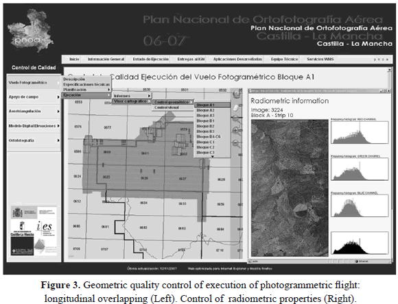
<body><![CDATA[<p><font size="3" face="Verdana, Arial, Helvetica, sans-serif"><b>4. QUALITY CONTROL</b></font></p>     <p><font size="2" face="Verdana, Arial, Helvetica, sans-serif">A fundamental aspect of the project is trying to implement efficient quality control methodologies that are appropriate to the technical specifications of the project. </font></p>     <p><font size="2" face="Verdana, Arial, Helvetica, sans-serif">The quality control processes, which take place in different phases of the PNOA project, are intended to ensure that the product meets the technical requirements for its operation. In a project such as this, it is essential not only to ensure the geometric accuracy and thematic quality of the final orthophoto but also to control each stage of production. Such control will avoid misleading results, both in final and intermediate products, meaning that they can all be used in other applications. For this purpose, a quality control suitable for each stage of the implementation of the photogrammetric process is established by coordinating the workflow toward the tasks developed by the company.</font></p>     <p><font size="2" face="Verdana, Arial, Helvetica, sans-serif">Because there has been a unique photogrammetric flight of the entire community, the volume of information that needs to be processed is crucial. To give an idea of the magnitude, the flight covers approximately 8.000.000 hectares. The information consists of approximately 24.000 images, and the area is formed by 2.617 cartographic maps - according to 1:10.000 scale distributions. </font></p>     <p><font size="2" face="Verdana, Arial, Helvetica, sans-serif">With these conditions, automating the processes is an essential step. Specific software has been developed &#91;25&#93; with the aim of automating the quality control of photogrammetric flights. </font></p>     <p><font size="2" face="Verdana, Arial, Helvetica, sans-serif">In particular, the quality control is proposed with a twofold purpose in mind: </font></p> <ul>   <li class="DYNA-normal para-style-override-11"><font size="2" face="Verdana, Arial, Helvetica, sans-serif">Controlling the geometric parameters, such as geo-referencing between different coordinate systems; controlling blocks, strips and overlaps; controlling vertical image deviation; and controlling scale. This final aspect has been rigorously analyzed based on the digital elevation model (DEM). </font></li>   <li class="DYNA-normal para-style-override-11"><font size="2" face="Verdana, Arial, Helvetica, sans-serif">Providing a radiometric calibration based on a vicarious method &#91;22&#93; and validating the thematic parameters obtained.</font></li>     </ul>     <p><font size="2" face="Verdana, Arial, Helvetica, sans-serif">A paragraph description summarizing the quality controls carried out in each stage is added, making the results more detailed. Another section reports the results of quality control in an alphanumeric form. The results are normally distributed in a table, where each record is identified as the basic unit of control, adding the definition of parameters necessary to establish whether that particular unit exceeds the quality control. As usual, a red color is used to identify those units that failed the quality control. </font></p>     <p><font size="2" face="Verdana, Arial, Helvetica, sans-serif">Finally, a map viewer that allows spatial visualization of the most interesting results of quality control has been included in each of the phases.</font></p>     <p><font size="2" face="Verdana, Arial, Helvetica, sans-serif">To sum up, quality control at different stages of the project is performed as follows (<a href="#fig03">Fig. 3</a>):</font></p> <ul>   <li class="DYNA-normal para-style-override-12"><font size="2" face="Verdana, Arial, Helvetica, sans-serif">Control of planning and execution of photogrammetric flight.</font></li>   <li class="DYNA-normal para-style-override-12"><font size="2" face="Verdana, Arial, Helvetica, sans-serif">Planning and execution of control and check points.</font></li>   <li class="DYNA-normal para-style-override-12"><font size="2" face="Verdana, Arial, Helvetica, sans-serif">Control of radiometric properties.</font></li>   <li class="DYNA-normal para-style-override-12"><font size="2" face="Verdana, Arial, Helvetica, sans-serif">Calculation and adjustment of aerial triangulation. </font></li>   <li class="DYNA-normal para-style-override-12"><font size="2" face="Verdana, Arial, Helvetica, sans-serif">Generation of Digital Elevation Models, including Digital Surface Models (DSM) and Digital Terrain Models (DTM).</font></li>   <li class="DYNA-normal para-style-override-12"><font size="2" face="Verdana, Arial, Helvetica, sans-serif">Generation of orthophotos.</font></li>     ]]></body>
<body><![CDATA[</ul>     <p align="center"><font size="2" face="Verdana, Arial, Helvetica, sans-serif"><a name="fig03"></a></font><img src="/img/revistas/dyna/v80n178/v80n178a16fig03.gif"></p>     <p><font face="Verdana, Arial, Helvetica, sans-serif"><b><font size="3">5. EXTRACTION OF THEMATIC INFORMATION</font></b></font></p>     <p><font size="2" face="Verdana, Arial, Helvetica, sans-serif">Once the aerial images have been oriented and geo-referenced &#91;26&#93;, the extraction of thematic information is usually performed, but based on different, non-rigorous and subjective </font></p>     <p><font size="2" face="Verdana, Arial, Helvetica, sans-serif">criteria. The main goal is to provide a final orthophoto with a continuous appearance without gaps or radiometric alterations. To perform an objective and automatic homogenization of images, as well as the extraction of thematic information, radiometric camera calibration should be mandatory. In this project, the method of vicarious calibration based on reflectance, has been applied. In particular, the radiative transfer equation used for implementation and atmospheric characterization is model 6S &#91;27&#93;. In this manner, radiometric calibration parameters and reflectance and radiance images are obtained at the ground level, which could be of great interest for thematic applications. Some analyses were performed to determine whether radiometric measurements can be extrapolated to other spatial locations. This information could be of interest because a public database of radiometric control points could be maintained prior to the photogrammetric flight. The results obtained were promising, given that they range within a 3-5% threshold, depending on the band &#91;22&#93;. The publication of reflectance and radiance images is supported by the Web Coverage Service (WCS), which allows us to exploit the physical magnitudes of images. <a href="#fig04">Fig. 4</a> shows an RGB orthophoto in natural color and false color infrared (CIR). It can be observed that the first and third images do not provide a continuous transition because the radiometric calibration has not been performed. In contrast, the second (RBG) and fourth (CIR) images present a better transition, with great homogeneity for both images.</font></p>     <p align="center"><font size="2" face="Verdana, Arial, Helvetica, sans-serif"><a name="fig04"></a></font><img src="/img/revistas/dyna/v80n178/v80n178a16fig04.gif"></p>     <p>&nbsp;</p>     <p><font size="3" face="Verdana, Arial, Helvetica, sans-serif"><b>6.  CONCLUDING REMARKS AND FUTURE PERSPECTIVES</b></font></p>     <p><font size="2" face="Verdana, Arial, Helvetica, sans-serif">Once the project has been accomplished, it can be concluded that the project adheres to the methodology, the system development and the technologies required for efficient project management.</font></p>     <p><font size="2" face="Verdana, Arial, Helvetica, sans-serif">The system's main advantages are the following:</font></p> <ul>   <li class="DYNA-normal para-style-override-12"><font size="2" face="Verdana, Arial, Helvetica, sans-serif">The ability to adapt to the needs of the project.</font></li>   <li class="DYNA-normal para-style-override-12"><font size="2" face="Verdana, Arial, Helvetica, sans-serif">The integration of different elements, which facilitates their independence so that, if necessary, the change of any component will not affect the whole system but only the element to be modified.</font></li>   <li class="DYNA-normal para-style-override-12"><font size="2" face="Verdana, Arial, Helvetica, sans-serif">The possibility of updating the spatial and thematic information database with flexibility.</font></li>   <li class="DYNA-normal para-style-override-12"><font size="2" face="Verdana, Arial, Helvetica, sans-serif">All the map viewers are based on SDI specifications, most of which are WMS because it follows the OGC standards and, thus, can be used from other applications and platforms. One of the most recent applications is automatic detection based on these services &#91;28&#93;. </font></li>     ]]></body>
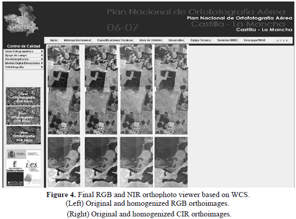
<body><![CDATA[</ul>     <p><font size="2" face="Verdana, Arial, Helvetica, sans-serif">The proposed system opens new lines of work, such as the incorporation of WFS-Web Feature Services for the management of vector data. Moreover, the recent emergence of new sensors, such as aerial linear cameras and airborne laser systems, which are being used in the PNOA project, will prove that the existing strategies and methods have to be re-implemented to carry out the technical management and quality control. As a result, the Spanish National Aerial Orthophotography program is a dynamic project that requires constant updating to increase its capacities and functionalities.</font></p>     <p>&nbsp;</p>     <p><font size="3" face="Verdana, Arial, Helvetica, sans-serif"><b>REFERENCES</b></font></p>     <!-- ref --><p><font size="2" face="Verdana, Arial, Helvetica, sans-serif"><b>&#91;1&#93;</b> Kingston, R., Carver, S., Evans, A. and Turton, I., Web-based public participation geographical information systems: an aid to local environmental decision-making, Computers, Environment and Urban Systems, 24(2), pp. 109-125, 2000.    &nbsp;&nbsp;&nbsp;&nbsp;&nbsp;&nbsp;&nbsp;&nbsp;[&#160;<a href="javascript:void(0);" onclick="javascript: window.open('/scielo.php?script=sci_nlinks&ref=000087&pid=S0012-7353201300020001600001&lng=','','width=640,height=500,resizable=yes,scrollbars=1,menubar=yes,');">Links</a>&#160;]<!-- end-ref --><!-- ref --><br>   <b>&#91;2&#93;</b> Nedovic-Budic, Z., Feeney, M. F., Rajabifard, A. and Williamson, I., Are SDIs serving the needs of local planning? Case study of Victoria, Australia and Illinois, USA, Computers, Environment and Urban Systems, 28(4), pp. 329-351, 2004.    &nbsp;&nbsp;&nbsp;&nbsp;&nbsp;&nbsp;&nbsp;&nbsp;[&#160;<a href="javascript:void(0);" onclick="javascript: window.open('/scielo.php?script=sci_nlinks&ref=000088&pid=S0012-7353201300020001600002&lng=','','width=640,height=500,resizable=yes,scrollbars=1,menubar=yes,');">Links</a>&#160;]<!-- end-ref --><!-- ref --><br>   <b>&#91;3&#93;</b> Di, L., Zhao, P., Yang, W., Yu, G. and Yue, P., Intelligent geospatial web services. Proceedings of Geoscience and Remote Sensing symposium, pp. 1229-1232, 2005.    &nbsp;&nbsp;&nbsp;&nbsp;&nbsp;&nbsp;&nbsp;&nbsp;[&#160;<a href="javascript:void(0);" onclick="javascript: window.open('/scielo.php?script=sci_nlinks&ref=000089&pid=S0012-7353201300020001600003&lng=','','width=640,height=500,resizable=yes,scrollbars=1,menubar=yes,');">Links</a>&#160;]<!-- end-ref --><!-- ref --><br>   <b>&#91;4&#93;</b> Wu, H., Li, Z., Zhang, H., Yang, C. and Shen, S., Monitoring and evaluating the quality of Web Map Service resources for optimizing map composition over the internet to support decision making, Computers & Geosciences, 37(4), pp. 485-494, 2011.    &nbsp;&nbsp;&nbsp;&nbsp;&nbsp;&nbsp;&nbsp;&nbsp;[&#160;<a href="javascript:void(0);" onclick="javascript: window.open('/scielo.php?script=sci_nlinks&ref=000090&pid=S0012-7353201300020001600004&lng=','','width=640,height=500,resizable=yes,scrollbars=1,menubar=yes,');">Links</a>&#160;]<!-- end-ref --><!-- ref --><br>   <b>&#91;5&#93;</b> Vaughan-Nichols, S., Web services: Beyond the hype, IEEE Computer, 35(2), pp. 18-21, 2002.    &nbsp;&nbsp;&nbsp;&nbsp;&nbsp;&nbsp;&nbsp;&nbsp;[&#160;<a href="javascript:void(0);" onclick="javascript: window.open('/scielo.php?script=sci_nlinks&ref=000091&pid=S0012-7353201300020001600005&lng=','','width=640,height=500,resizable=yes,scrollbars=1,menubar=yes,');">Links</a>&#160;]<!-- end-ref --><!-- ref --><br>   <b>&#91;6&#93;</b> Zapata, C. M., Toro, F. M. and Mar&iacute;n, M. I., Mapwindow vs. Arcgis: towards featuring the Interoperability between geographic information Systems, Revista DYNA, 79(173), pp. 25-33, 2012.    &nbsp;&nbsp;&nbsp;&nbsp;&nbsp;&nbsp;&nbsp;&nbsp;[&#160;<a href="javascript:void(0);" onclick="javascript: window.open('/scielo.php?script=sci_nlinks&ref=000092&pid=S0012-7353201300020001600006&lng=','','width=640,height=500,resizable=yes,scrollbars=1,menubar=yes,');">Links</a>&#160;]<!-- end-ref --><!-- ref --><br>   <b>&#91;7&#93;</b> Mackaness, W.A., Ruas, A. and Sarjakoski, L.T., Generalisation of geographic information: Cartographic modelling and applications, Elsevier, Amsterdam, 2007.    &nbsp;&nbsp;&nbsp;&nbsp;&nbsp;&nbsp;&nbsp;&nbsp;[&#160;<a href="javascript:void(0);" onclick="javascript: window.open('/scielo.php?script=sci_nlinks&ref=000093&pid=S0012-7353201300020001600007&lng=','','width=640,height=500,resizable=yes,scrollbars=1,menubar=yes,');">Links</a>&#160;]<!-- end-ref --><!-- ref --><br>   <b>&#91;8&#93;</b> Lehto, L., Real-time content transformations in a web servicebased delivery architecture for geographic information, &#91;PhD Thesis&#93;, Helsinki University of Technology, Department of Surveying, 2007.    &nbsp;&nbsp;&nbsp;&nbsp;&nbsp;&nbsp;&nbsp;&nbsp;[&#160;<a href="javascript:void(0);" onclick="javascript: window.open('/scielo.php?script=sci_nlinks&ref=000094&pid=S0012-7353201300020001600008&lng=','','width=640,height=500,resizable=yes,scrollbars=1,menubar=yes,');">Links</a>&#160;]<!-- end-ref --><!-- ref --><br>   <b>&#91;9&#93;</b> Foerster, T., Lehto, L., Sarjakoski, T., Sarjakoski, L.T. and Stoter, J., Map generalization and schema transformation of geospatial data combined in a Web Service context, Computers, Environment and Urban Systems, 34(1), pp. 79-88, 2010.    &nbsp;&nbsp;&nbsp;&nbsp;&nbsp;&nbsp;&nbsp;&nbsp;[&#160;<a href="javascript:void(0);" onclick="javascript: window.open('/scielo.php?script=sci_nlinks&ref=000095&pid=S0012-7353201300020001600009&lng=','','width=640,height=500,resizable=yes,scrollbars=1,menubar=yes,');">Links</a>&#160;]<!-- end-ref --><!-- ref --><br>   <b>&#91;10&#93;</b> Williamson, I., Rajabifard, A. and Feeney, M.F., Future directions in SDI development. In Developing spatial data infrastructures: From concept to reality, Taylor & Francis, pp. 301-312, 2003.    &nbsp;&nbsp;&nbsp;&nbsp;&nbsp;&nbsp;&nbsp;&nbsp;[&#160;<a href="javascript:void(0);" onclick="javascript: window.open('/scielo.php?script=sci_nlinks&ref=000096&pid=S0012-7353201300020001600010&lng=','','width=640,height=500,resizable=yes,scrollbars=1,menubar=yes,');">Links</a>&#160;]<!-- end-ref --><!-- ref --><br>   <b>&#91;11&#93;</b> Zhong, Y., Han, J., Zhang, T. and Fang, J., A distributed geospatial data storage and processing framework for large-scale WebGIS. Proceedings 20th International Conference on Geoinformatics, Geoinformatics, art. n&ordm;. 6270347, 2012.    &nbsp;&nbsp;&nbsp;&nbsp;&nbsp;&nbsp;&nbsp;&nbsp;[&#160;<a href="javascript:void(0);" onclick="javascript: window.open('/scielo.php?script=sci_nlinks&ref=000097&pid=S0012-7353201300020001600011&lng=','','width=640,height=500,resizable=yes,scrollbars=1,menubar=yes,');">Links</a>&#160;]<!-- end-ref --><!-- ref --><br>   <b>&#91;12&#93;</b> Zhang, J., A high-performance web-based information system for publishing large-scale species range maps in support of biodiversity studies, Ecological Informatics, 8, pp. 68-77, 2012.    &nbsp;&nbsp;&nbsp;&nbsp;&nbsp;&nbsp;&nbsp;&nbsp;[&#160;<a href="javascript:void(0);" onclick="javascript: window.open('/scielo.php?script=sci_nlinks&ref=000098&pid=S0012-7353201300020001600012&lng=','','width=640,height=500,resizable=yes,scrollbars=1,menubar=yes,');">Links</a>&#160;]<!-- end-ref --><!-- ref --><br>   <b>&#91;13&#93;</b> Huang, T. and Zhou, Y., Remote sensing and open source geographic information system integration. Proceedings of the 2nd International Workshop on Earth Observation and Remote Sensing Applications, pp. 254-258, 2012.    &nbsp;&nbsp;&nbsp;&nbsp;&nbsp;&nbsp;&nbsp;&nbsp;[&#160;<a href="javascript:void(0);" onclick="javascript: window.open('/scielo.php?script=sci_nlinks&ref=000099&pid=S0012-7353201300020001600013&lng=','','width=640,height=500,resizable=yes,scrollbars=1,menubar=yes,');">Links</a>&#160;]<!-- end-ref --><!-- ref --><br>   <b>&#91;14&#93;</b> Iosifescu-Enescu, I., Hugentobler, M., Hurni, L., Web cartography with open standards - A solution to cartographic challenges of environmental management. Environmental Modelling & Software, 25(9), Issue 9, pp. 988-999, 2010.    &nbsp;&nbsp;&nbsp;&nbsp;&nbsp;&nbsp;&nbsp;&nbsp;[&#160;<a href="javascript:void(0);" onclick="javascript: window.open('/scielo.php?script=sci_nlinks&ref=000100&pid=S0012-7353201300020001600014&lng=','','width=640,height=500,resizable=yes,scrollbars=1,menubar=yes,');">Links</a>&#160;]<!-- end-ref --><!-- ref --><br>   <b>&#91;15&#93;</b> Rautenbach, V., Coetzee, S. and Iwaniak, A., Orchestrating OGC web services to produce thematic maps in a spatial information infrastructure. Computers, Environment and Urban Systems (In Press, Corrected Proof). Available: <a href="http://www.sciencedirect.com/science/article/pii/S0198971512000774" target="referencia">http://www.sciencedirect.com/science/article/pii/S0198971512000774</a> &#91;Accessed November 8, 2012&#93;    &nbsp;&nbsp;&nbsp;&nbsp;&nbsp;&nbsp;&nbsp;&nbsp;[&#160;<a href="javascript:void(0);" onclick="javascript: window.open('/scielo.php?script=sci_nlinks&ref=000101&pid=S0012-7353201300020001600015&lng=','','width=640,height=500,resizable=yes,scrollbars=1,menubar=yes,');">Links</a>&#160;]<!-- end-ref --><!-- ref --><br>   <b>&#91;16&#93;</b> Han, W., Yang, Z., Di, L. and Mueller, R., CropScape: A Web service based application for exploring and disseminating US conterminous geospatial cropland data products for decision support, Computers and Electronics in Agriculture, 84, pp. 111-123, 2012.    &nbsp;&nbsp;&nbsp;&nbsp;&nbsp;&nbsp;&nbsp;&nbsp;[&#160;<a href="javascript:void(0);" onclick="javascript: window.open('/scielo.php?script=sci_nlinks&ref=000102&pid=S0012-7353201300020001600016&lng=','','width=640,height=500,resizable=yes,scrollbars=1,menubar=yes,');">Links</a>&#160;]<!-- end-ref --><!-- ref --><br>   <b>&#91;17&#93;</b> Mansourian, A., Valadan Zoje, M.J., Mohammadzadeh, A. and Farnaghi, M., Design and implementation of an on-demand feature extraction web service to facilitate development of spatial data infrastructures, Computers, Environment and Urban Systems, 32(5), pp. 377-385, 2008.    &nbsp;&nbsp;&nbsp;&nbsp;&nbsp;&nbsp;&nbsp;&nbsp;[&#160;<a href="javascript:void(0);" onclick="javascript: window.open('/scielo.php?script=sci_nlinks&ref=000103&pid=S0012-7353201300020001600017&lng=','','width=640,height=500,resizable=yes,scrollbars=1,menubar=yes,');">Links</a>&#160;]<!-- end-ref --><!-- ref --><br>   <b>&#91;18&#93;</b> Gkatzoflias, D., Mellios, G., Samaras, Z., Development of a web GIS application for emissions inventory spatial allocation based on open source software tools, Computers & Geosciences, 2012. Available: <a href="http://www.sciencedirect.com/science/article/pii/S0098300412003512?v=s5" target="referencia">http://www.sciencedirect.com/science/article/pii/S0098300412003512?v=s5</a> &#91;Accessed November 8, 2012&#93;    &nbsp;&nbsp;&nbsp;&nbsp;&nbsp;&nbsp;&nbsp;&nbsp;[&#160;<a href="javascript:void(0);" onclick="javascript: window.open('/scielo.php?script=sci_nlinks&ref=000104&pid=S0012-7353201300020001600018&lng=','','width=640,height=500,resizable=yes,scrollbars=1,menubar=yes,');">Links</a>&#160;]<!-- end-ref --><!-- ref --><br>   <b>&#91;19&#93;</b> De Longueville, B., Community-based geoportals: The next generation? Concepts and methods for the geospatial Web 2.0. Computers, Environment and Urban Systems, 34 (4), pp. 299-308, 2010.    &nbsp;&nbsp;&nbsp;&nbsp;&nbsp;&nbsp;&nbsp;&nbsp;[&#160;<a href="javascript:void(0);" onclick="javascript: window.open('/scielo.php?script=sci_nlinks&ref=000105&pid=S0012-7353201300020001600019&lng=','','width=640,height=500,resizable=yes,scrollbars=1,menubar=yes,');">Links</a>&#160;]<!-- end-ref --><!-- ref --><br>   <b>&#91;20&#93;</b> Arozarena, A., Garc&iacute;a, L., Villa, G., Hermosilla, J., Papi, F., Valc&aacute;rcel, N., Peces, J., Domenech, E., Garc&iacute;a, C., Tejeiro, J., Spanish National Plan for Territory Observation (PNOT). Proceedings of the International Archives of the Photogrammetry, Remote Sensing and Spatial Information Sciences, Beijing, China, Vol. XXXVII (Part B4), pp. 1729-1733, 2008.    &nbsp;&nbsp;&nbsp;&nbsp;&nbsp;&nbsp;&nbsp;&nbsp;[&#160;<a href="javascript:void(0);" onclick="javascript: window.open('/scielo.php?script=sci_nlinks&ref=000106&pid=S0012-7353201300020001600020&lng=','','width=640,height=500,resizable=yes,scrollbars=1,menubar=yes,');">Links</a>&#160;]<!-- end-ref --><!-- ref --><br>   <b>&#91;21&#93;</b> OGC. Open GIS web processing service. OGC implementation specification, open geospatial consortium. Available: <a href="http://www.opengeospatial.org/standards/wps" target="referencia">http://www.opengeospatial.org/standards/wps</a> &#91;Accessed October 26, 2011&#93;    &nbsp;&nbsp;&nbsp;&nbsp;&nbsp;&nbsp;&nbsp;&nbsp;[&#160;<a href="javascript:void(0);" onclick="javascript: window.open('/scielo.php?script=sci_nlinks&ref=000107&pid=S0012-7353201300020001600021&lng=','','width=640,height=500,resizable=yes,scrollbars=1,menubar=yes,');">Links</a>&#160;]<!-- end-ref -->.    <!-- ref --><br>   <b>&#91;22&#93;</b> Hern&aacute;ndez L&oacute;pez, D., Felipe Garc&iacute;a, B., Gonz&aacute;lez Piqueras, J., Villa Alc&aacute;zar, G., An approach to the radiometric aerotriangulation of photogrammetric image, ISPRS J. of Photogrammetry and Remote Sensing, 66, pp. 883-893, 2011.    &nbsp;&nbsp;&nbsp;&nbsp;&nbsp;&nbsp;&nbsp;&nbsp;[&#160;<a href="javascript:void(0);" onclick="javascript: window.open('/scielo.php?script=sci_nlinks&ref=000109&pid=S0012-7353201300020001600022&lng=','','width=640,height=500,resizable=yes,scrollbars=1,menubar=yes,');">Links</a>&#160;]<!-- end-ref --><!-- ref --><br>   <b>&#91;23&#93;</b> Staub, P., Gnaegi, H.R. and Morf, A., Semantic interoperability through the definition of conceptual model transformations. Transactions in GIS, 12(2), pp. 193-207, 2008.    &nbsp;&nbsp;&nbsp;&nbsp;&nbsp;&nbsp;&nbsp;&nbsp;[&#160;<a href="javascript:void(0);" onclick="javascript: window.open('/scielo.php?script=sci_nlinks&ref=000110&pid=S0012-7353201300020001600023&lng=','','width=640,height=500,resizable=yes,scrollbars=1,menubar=yes,');">Links</a>&#160;]<!-- end-ref --><!-- ref --><br>   <b>&#91;24&#93;</b> Yue, P., Di, L., Yang, W., Yu, G., Zhao, P., Semantics-based automatic composition of geospatial Web service chains, Computers & Geosciences, 33(5), pp. 649-665, 2007.    &nbsp;&nbsp;&nbsp;&nbsp;&nbsp;&nbsp;&nbsp;&nbsp;[&#160;<a href="javascript:void(0);" onclick="javascript: window.open('/scielo.php?script=sci_nlinks&ref=000111&pid=S0012-7353201300020001600024&lng=','','width=640,height=500,resizable=yes,scrollbars=1,menubar=yes,');">Links</a>&#160;]<!-- end-ref --><!-- ref --><br>   <b>&#91;25&#93;</b> Felipe, B., Desarrollo metodol&oacute;gico y de software para el control de calidad del Plan Nacional de Ortofotograf&iacute;a A&eacute;rea, PNOA, &#91;Phd Thesis&#93;, Departamento de Ingenier&iacute;a Cartogr&aacute;fica, Geodesia y Fotogrametr&iacute;a, Universidad Polit&eacute;cnica de Valencia, Valencia, Espa&ntilde;a, 2010.    &nbsp;&nbsp;&nbsp;&nbsp;&nbsp;&nbsp;&nbsp;&nbsp;[&#160;<a href="javascript:void(0);" onclick="javascript: window.open('/scielo.php?script=sci_nlinks&ref=000112&pid=S0012-7353201300020001600025&lng=','','width=640,height=500,resizable=yes,scrollbars=1,menubar=yes,');">Links</a>&#160;]<!-- end-ref --><!-- ref --><br>   <b>&#91;26&#93;</b> Kraus, K., Photogrammetry, &Uuml;mmler, Bonn, 1997.    &nbsp;&nbsp;&nbsp;&nbsp;&nbsp;&nbsp;&nbsp;&nbsp;[&#160;<a href="javascript:void(0);" onclick="javascript: window.open('/scielo.php?script=sci_nlinks&ref=000113&pid=S0012-7353201300020001600026&lng=','','width=640,height=500,resizable=yes,scrollbars=1,menubar=yes,');">Links</a>&#160;]<!-- end-ref --><!-- ref --><br>   <b>&#91;27&#93;</b> Vermote, E., Tanr&eacute;, D., Deuz&eacute;, J., Herman, M. and Moncrette, J., Second Simulation of the Satellite Signal in the Solar Spectrum, 6S: An Overview. IEEE Transactions on Geoscience and Remote Sensing, 35(3), pp. 675-686, 1997.    &nbsp;&nbsp;&nbsp;&nbsp;&nbsp;&nbsp;&nbsp;&nbsp;[&#160;<a href="javascript:void(0);" onclick="javascript: window.open('/scielo.php?script=sci_nlinks&ref=000114&pid=S0012-7353201300020001600027&lng=','','width=640,height=500,resizable=yes,scrollbars=1,menubar=yes,');">Links</a>&#160;]<!-- end-ref --><!-- ref --><br>   <b>&#91;28&#93;</b> Florczyk, A.J., Nogueras-Iso, J., Zarazaga-Soria, F.J. and B&eacute;jar, R., Identifying orthoimages in Web Map Services. Computers & Geosciences, 47, pp. 130-142, 2012.    &nbsp;&nbsp;&nbsp;&nbsp;&nbsp;&nbsp;&nbsp;&nbsp;[&#160;<a href="javascript:void(0);" onclick="javascript: window.open('/scielo.php?script=sci_nlinks&ref=000115&pid=S0012-7353201300020001600028&lng=','','width=640,height=500,resizable=yes,scrollbars=1,menubar=yes,');">Links</a>&#160;]<!-- end-ref --> </font></p>      ]]></body><back>
<ref-list>
<ref id="B1">
<label>1</label><nlm-citation citation-type="journal">
<person-group person-group-type="author">
<name>
<surname><![CDATA[Kingston]]></surname>
<given-names><![CDATA[R.]]></given-names>
</name>
<name>
<surname><![CDATA[Carver]]></surname>
<given-names><![CDATA[S.]]></given-names>
</name>
<name>
<surname><![CDATA[Evans]]></surname>
<given-names><![CDATA[A.]]></given-names>
</name>
<name>
<surname><![CDATA[Turton]]></surname>
<given-names><![CDATA[I.]]></given-names>
</name>
</person-group>
<article-title xml:lang="en"><![CDATA[Web-based public participation geographical information systems: an aid to local environmental decision-making]]></article-title>
<source><![CDATA[Computers, Environment and Urban Systems]]></source>
<year>2000</year>
<volume>24</volume>
<numero>2</numero>
<issue>2</issue>
<page-range>109-125</page-range></nlm-citation>
</ref>
<ref id="B2">
<label>2</label><nlm-citation citation-type="journal">
<person-group person-group-type="author">
<name>
<surname><![CDATA[Nedovic-Budic]]></surname>
<given-names><![CDATA[Z.]]></given-names>
</name>
<name>
<surname><![CDATA[Feeney]]></surname>
<given-names><![CDATA[M. F.]]></given-names>
</name>
<name>
<surname><![CDATA[Rajabifard]]></surname>
<given-names><![CDATA[A.]]></given-names>
</name>
<name>
<surname><![CDATA[Williamson]]></surname>
<given-names><![CDATA[I.]]></given-names>
</name>
</person-group>
<article-title xml:lang="en"><![CDATA[Are SDIs serving the needs of local planning?: Case study of Victoria, Australia and Illinois, USA]]></article-title>
<source><![CDATA[Computers, Environment and Urban Systems]]></source>
<year>2004</year>
<volume>28</volume>
<numero>4</numero>
<issue>4</issue>
<page-range>329-351</page-range></nlm-citation>
</ref>
<ref id="B3">
<label>3</label><nlm-citation citation-type="confpro">
<person-group person-group-type="author">
<name>
<surname><![CDATA[Di]]></surname>
<given-names><![CDATA[L.]]></given-names>
</name>
<name>
<surname><![CDATA[Zhao]]></surname>
<given-names><![CDATA[P.]]></given-names>
</name>
<name>
<surname><![CDATA[Yang]]></surname>
<given-names><![CDATA[W.]]></given-names>
</name>
<name>
<surname><![CDATA[Yu]]></surname>
<given-names><![CDATA[G.]]></given-names>
</name>
<name>
<surname><![CDATA[Yue]]></surname>
<given-names><![CDATA[P.]]></given-names>
</name>
</person-group>
<article-title xml:lang="en"><![CDATA[Intelligent geospatial web services]]></article-title>
<source><![CDATA[]]></source>
<year>2005</year>
<conf-name><![CDATA[ Geoscience and Remote Sensing symposium]]></conf-name>
<conf-loc> </conf-loc>
<page-range>1229-1232</page-range></nlm-citation>
</ref>
<ref id="B4">
<label>4</label><nlm-citation citation-type="journal">
<person-group person-group-type="author">
<name>
<surname><![CDATA[Wu]]></surname>
<given-names><![CDATA[H.]]></given-names>
</name>
<name>
<surname><![CDATA[Li]]></surname>
<given-names><![CDATA[Z.]]></given-names>
</name>
<name>
<surname><![CDATA[Zhang]]></surname>
<given-names><![CDATA[H.]]></given-names>
</name>
<name>
<surname><![CDATA[Yang]]></surname>
<given-names><![CDATA[C.]]></given-names>
</name>
<name>
<surname><![CDATA[Shen]]></surname>
<given-names><![CDATA[S.]]></given-names>
</name>
</person-group>
<article-title xml:lang="en"><![CDATA[Monitoring and evaluating the quality of Web Map Service resources for optimizing map composition over the internet to support decision making]]></article-title>
<source><![CDATA[Computers & Geosciences]]></source>
<year>2011</year>
<volume>37</volume>
<numero>4</numero>
<issue>4</issue>
<page-range>485-494</page-range></nlm-citation>
</ref>
<ref id="B5">
<label>5</label><nlm-citation citation-type="journal">
<person-group person-group-type="author">
<name>
<surname><![CDATA[Vaughan-Nichols]]></surname>
<given-names><![CDATA[S.]]></given-names>
</name>
</person-group>
<article-title xml:lang="en"><![CDATA[Web services: Beyond the hype]]></article-title>
<source><![CDATA[IEEE Computer]]></source>
<year>2002</year>
<volume>35</volume>
<numero>2</numero>
<issue>2</issue>
<page-range>18-21</page-range></nlm-citation>
</ref>
<ref id="B6">
<label>6</label><nlm-citation citation-type="journal">
<person-group person-group-type="author">
<name>
<surname><![CDATA[Zapata]]></surname>
<given-names><![CDATA[C. M.]]></given-names>
</name>
<name>
<surname><![CDATA[Toro]]></surname>
<given-names><![CDATA[F. M.]]></given-names>
</name>
<name>
<surname><![CDATA[Marín]]></surname>
<given-names><![CDATA[M. I.]]></given-names>
</name>
</person-group>
<article-title xml:lang="en"><![CDATA[Mapwindow vs. Arcgis: rds featuring the Interoperability between geographic information Systems]]></article-title>
<source><![CDATA[Revista DYNA]]></source>
<year>2012</year>
<volume>79</volume>
<numero>173</numero>
<issue>173</issue>
<page-range>25-33</page-range></nlm-citation>
</ref>
<ref id="B7">
<label>7</label><nlm-citation citation-type="book">
<person-group person-group-type="author">
<name>
<surname><![CDATA[Mackaness]]></surname>
<given-names><![CDATA[W.A.]]></given-names>
</name>
<name>
<surname><![CDATA[Ruas]]></surname>
<given-names><![CDATA[A.]]></given-names>
</name>
<name>
<surname><![CDATA[Sarjakoski]]></surname>
<given-names><![CDATA[L.T.]]></given-names>
</name>
</person-group>
<source><![CDATA[Generalisation of geographic information: Cartographic modelling and applications]]></source>
<year>2007</year>
<publisher-loc><![CDATA[Amsterdam ]]></publisher-loc>
<publisher-name><![CDATA[Elsevier]]></publisher-name>
</nlm-citation>
</ref>
<ref id="B8">
<label>8</label><nlm-citation citation-type="">
<person-group person-group-type="author">
<name>
<surname><![CDATA[Lehto]]></surname>
<given-names><![CDATA[L.]]></given-names>
</name>
</person-group>
<source><![CDATA[Real-time content transformations in a web servicebased delivery architecture for geographic information]]></source>
<year></year>
</nlm-citation>
</ref>
<ref id="B9">
<label>9</label><nlm-citation citation-type="journal">
<person-group person-group-type="author">
<name>
<surname><![CDATA[Foerster]]></surname>
<given-names><![CDATA[T.]]></given-names>
</name>
<name>
<surname><![CDATA[Lehto]]></surname>
<given-names><![CDATA[L.]]></given-names>
</name>
<name>
<surname><![CDATA[Sarjakoski]]></surname>
<given-names><![CDATA[T.]]></given-names>
</name>
<name>
<surname><![CDATA[Sarjakoski]]></surname>
<given-names><![CDATA[L.T.]]></given-names>
</name>
<name>
<surname><![CDATA[Stoter]]></surname>
<given-names><![CDATA[J.]]></given-names>
</name>
</person-group>
<article-title xml:lang="en"><![CDATA[Map generalization and schema transformation of geospatial data combined in a Web Service context]]></article-title>
<source><![CDATA[Computers, Environment and Urban Systems]]></source>
<year>2010</year>
<volume>34</volume>
<numero>1</numero>
<issue>1</issue>
<page-range>79-88</page-range></nlm-citation>
</ref>
<ref id="B10">
<label>10</label><nlm-citation citation-type="book">
<person-group person-group-type="author">
<name>
<surname><![CDATA[Williamson]]></surname>
<given-names><![CDATA[I.]]></given-names>
</name>
<name>
<surname><![CDATA[Rajabifard]]></surname>
<given-names><![CDATA[A.]]></given-names>
</name>
<name>
<surname><![CDATA[Feeney]]></surname>
<given-names><![CDATA[M.F.]]></given-names>
</name>
</person-group>
<article-title xml:lang="en"><![CDATA[Future directions in SDI development]]></article-title>
<source><![CDATA[Developing spatial data infrastructures: From concept to reality]]></source>
<year>2003</year>
<page-range>301-312</page-range><publisher-name><![CDATA[Taylor & Francis]]></publisher-name>
</nlm-citation>
</ref>
<ref id="B11">
<label>11</label><nlm-citation citation-type="confpro">
<person-group person-group-type="author">
<name>
<surname><![CDATA[Zhong]]></surname>
<given-names><![CDATA[Y.]]></given-names>
</name>
<name>
<surname><![CDATA[Han]]></surname>
<given-names><![CDATA[J.]]></given-names>
</name>
<name>
<surname><![CDATA[Zhang]]></surname>
<given-names><![CDATA[T.]]></given-names>
</name>
<name>
<surname><![CDATA[Fang]]></surname>
<given-names><![CDATA[J.]]></given-names>
</name>
</person-group>
<article-title xml:lang="en"><![CDATA[A distributed geospatial data storage and processing framework for large-scale WebGIS]]></article-title>
<source><![CDATA[]]></source>
<year></year>
<conf-name><![CDATA[20th International Conference on Geoinformatics, Geoinformatics]]></conf-name>
<conf-date>2012</conf-date>
<conf-loc> </conf-loc>
</nlm-citation>
</ref>
<ref id="B12">
<label>12</label><nlm-citation citation-type="journal">
<person-group person-group-type="author">
<name>
<surname><![CDATA[Zhang]]></surname>
<given-names><![CDATA[J.]]></given-names>
</name>
</person-group>
<article-title xml:lang="en"><![CDATA[A high-performance web-based information system for publishing large-scale species range maps in support of biodiversity studies]]></article-title>
<source><![CDATA[Ecological Informatics]]></source>
<year>2012</year>
<numero>8</numero>
<issue>8</issue>
<page-range>68-77</page-range></nlm-citation>
</ref>
<ref id="B13">
<label>13</label><nlm-citation citation-type="confpro">
<person-group person-group-type="author">
<name>
<surname><![CDATA[Huang]]></surname>
<given-names><![CDATA[T.]]></given-names>
</name>
<name>
<surname><![CDATA[Zhou]]></surname>
<given-names><![CDATA[Y.]]></given-names>
</name>
</person-group>
<article-title xml:lang="en"><![CDATA[Remote sensing and open source geographic information system integration]]></article-title>
<source><![CDATA[Proceedings]]></source>
<year>2012</year>
<conf-name><![CDATA[2nd International Workshop on Earth Observation and Remote Sensing Applications]]></conf-name>
<conf-loc> </conf-loc>
<page-range>254-258</page-range></nlm-citation>
</ref>
<ref id="B14">
<label>14</label><nlm-citation citation-type="journal">
<person-group person-group-type="author">
<name>
<surname><![CDATA[Iosifescu-Enescu]]></surname>
<given-names><![CDATA[I.]]></given-names>
</name>
<name>
<surname><![CDATA[Hugentobler]]></surname>
<given-names><![CDATA[M.]]></given-names>
</name>
<name>
<surname><![CDATA[Hurni]]></surname>
<given-names><![CDATA[L.]]></given-names>
</name>
</person-group>
<article-title xml:lang="en"><![CDATA[Web cartography with open standards - A solution to cartographic challenges of environmental management]]></article-title>
<source><![CDATA[Environmental Modelling & Software]]></source>
<year>2010</year>
<volume>25</volume>
<numero>9</numero>
<issue>9</issue>
<page-range>988-999</page-range></nlm-citation>
</ref>
<ref id="B15">
<label>15</label><nlm-citation citation-type="journal">
<person-group person-group-type="author">
<name>
<surname><![CDATA[Rautenbach]]></surname>
<given-names><![CDATA[V.]]></given-names>
</name>
<name>
<surname><![CDATA[Coetzee]]></surname>
<given-names><![CDATA[S.]]></given-names>
</name>
<name>
<surname><![CDATA[Iwaniak]]></surname>
<given-names><![CDATA[A.]]></given-names>
</name>
</person-group>
<article-title xml:lang="en"><![CDATA[Orchestrating OGC web services to produce thematic maps in a spatial information infrastructure]]></article-title>
<source><![CDATA[Computers, Environment and Urban Systems]]></source>
<year></year>
</nlm-citation>
</ref>
<ref id="B16">
<label>16</label><nlm-citation citation-type="journal">
<person-group person-group-type="author">
<name>
<surname><![CDATA[Han]]></surname>
<given-names><![CDATA[W.]]></given-names>
</name>
<name>
<surname><![CDATA[Yang]]></surname>
<given-names><![CDATA[Z.]]></given-names>
</name>
<name>
<surname><![CDATA[Di]]></surname>
<given-names><![CDATA[L.]]></given-names>
</name>
<name>
<surname><![CDATA[Mueller]]></surname>
<given-names><![CDATA[R.]]></given-names>
</name>
</person-group>
<article-title xml:lang="en"><![CDATA[CropScape: A Web service based application for exploring and disseminating US conterminous geospatial cropland data products for decision support]]></article-title>
<source><![CDATA[Computers and Electronics in Agriculture]]></source>
<year>2012</year>
<numero>84</numero>
<issue>84</issue>
<page-range>111-123</page-range></nlm-citation>
</ref>
<ref id="B17">
<label>17</label><nlm-citation citation-type="journal">
<person-group person-group-type="author">
<name>
<surname><![CDATA[Mansourian]]></surname>
<given-names><![CDATA[A.]]></given-names>
</name>
<name>
<surname><![CDATA[Valadan Zoje]]></surname>
<given-names><![CDATA[M.J.]]></given-names>
</name>
<name>
<surname><![CDATA[Mohammadzadeh]]></surname>
<given-names><![CDATA[A.]]></given-names>
</name>
<name>
<surname><![CDATA[Farnaghi]]></surname>
<given-names><![CDATA[M.]]></given-names>
</name>
</person-group>
<article-title xml:lang="en"><![CDATA[Design and implementation of an on-demand feature extraction web service to facilitate development of spatial data infrastructures]]></article-title>
<source><![CDATA[Computers, Environment and Urban Systems]]></source>
<year>2008</year>
<volume>32</volume>
<numero>5</numero>
<issue>5</issue>
<page-range>377-385</page-range></nlm-citation>
</ref>
<ref id="B18">
<label>18</label><nlm-citation citation-type="journal">
<person-group person-group-type="author">
<name>
<surname><![CDATA[Gkatzoflias]]></surname>
<given-names><![CDATA[D.]]></given-names>
</name>
<name>
<surname><![CDATA[Mellios]]></surname>
<given-names><![CDATA[G.]]></given-names>
</name>
<name>
<surname><![CDATA[Samaras]]></surname>
<given-names><![CDATA[Z.]]></given-names>
</name>
</person-group>
<article-title xml:lang="en"><![CDATA[Development of a web GIS application for emissions inventory spatial allocation based on open source software tools]]></article-title>
<source><![CDATA[Computers & Geosciences]]></source>
<year>2012</year>
</nlm-citation>
</ref>
<ref id="B19">
<label>19</label><nlm-citation citation-type="journal">
<person-group person-group-type="author">
<name>
<surname><![CDATA[De Longueville]]></surname>
<given-names><![CDATA[B.]]></given-names>
</name>
</person-group>
<article-title xml:lang="en"><![CDATA[Community-based geoportals: The next generation?: Concepts and methods for the geospatial Web 2.0]]></article-title>
<source><![CDATA[Computers, Environment and Urban Systems]]></source>
<year>2010</year>
<volume>34</volume>
<numero>4</numero>
<issue>4</issue>
<page-range>299-308</page-range></nlm-citation>
</ref>
<ref id="B20">
<label>20</label><nlm-citation citation-type="confpro">
<person-group person-group-type="author">
<name>
<surname><![CDATA[Arozarena]]></surname>
<given-names><![CDATA[A.]]></given-names>
</name>
<name>
<surname><![CDATA[García]]></surname>
<given-names><![CDATA[L.]]></given-names>
</name>
<name>
<surname><![CDATA[Villa]]></surname>
<given-names><![CDATA[G.]]></given-names>
</name>
<name>
<surname><![CDATA[Hermosilla]]></surname>
<given-names><![CDATA[J.]]></given-names>
</name>
<name>
<surname><![CDATA[Papi]]></surname>
<given-names><![CDATA[F.]]></given-names>
</name>
<name>
<surname><![CDATA[Valcárcel]]></surname>
<given-names><![CDATA[N.]]></given-names>
</name>
<name>
<surname><![CDATA[Peces]]></surname>
<given-names><![CDATA[J.]]></given-names>
</name>
<name>
<surname><![CDATA[Domenech]]></surname>
<given-names><![CDATA[E.]]></given-names>
</name>
<name>
<surname><![CDATA[García]]></surname>
<given-names><![CDATA[C.]]></given-names>
</name>
<name>
<surname><![CDATA[Tejeiro]]></surname>
<given-names><![CDATA[J.]]></given-names>
</name>
</person-group>
<article-title xml:lang="en"><![CDATA[Spanish National Plan for Territory Observation (PNOT)]]></article-title>
<source><![CDATA[]]></source>
<year>2008</year>
<volume>XXXVII</volume>
<conf-name><![CDATA[ International Archives of the Photogrammetry, Remote Sensing and Spatial Information Sciences]]></conf-name>
<conf-loc>Beijing </conf-loc>
<page-range>1729-1733</page-range></nlm-citation>
</ref>
<ref id="B21">
<label>21</label><nlm-citation citation-type="book">
<collab>OGC</collab>
<source><![CDATA[Open GIS web processing service: OGC implementation specification]]></source>
<year></year>
<publisher-name><![CDATA[open geospatial consortium]]></publisher-name>
</nlm-citation>
</ref>
<ref id="B22">
<label>22</label><nlm-citation citation-type="journal">
<person-group person-group-type="author">
<name>
<surname><![CDATA[Hernández López]]></surname>
<given-names><![CDATA[D.]]></given-names>
</name>
<name>
<surname><![CDATA[Felipe García]]></surname>
<given-names><![CDATA[B.]]></given-names>
</name>
<name>
<surname><![CDATA[González Piqueras]]></surname>
<given-names><![CDATA[J.]]></given-names>
</name>
<name>
<surname><![CDATA[Villa Alcázar]]></surname>
<given-names><![CDATA[G.]]></given-names>
</name>
</person-group>
<article-title xml:lang="en"><![CDATA[An approach to the radiometric aerotriangulation of photogrammetric image]]></article-title>
<source><![CDATA[ISPRS J. of Photogrammetry and Remote Sensing]]></source>
<year>2011</year>
<numero>66</numero>
<issue>66</issue>
<page-range>883-893</page-range></nlm-citation>
</ref>
<ref id="B23">
<label>23</label><nlm-citation citation-type="journal">
<person-group person-group-type="author">
<name>
<surname><![CDATA[Staub]]></surname>
<given-names><![CDATA[P.]]></given-names>
</name>
<name>
<surname><![CDATA[Gnaegi]]></surname>
<given-names><![CDATA[H.R.]]></given-names>
</name>
<name>
<surname><![CDATA[Morf]]></surname>
<given-names><![CDATA[A.]]></given-names>
</name>
</person-group>
<article-title xml:lang="en"><![CDATA[Semantic interoperability through the definition of conceptual model transformations]]></article-title>
<source><![CDATA[Transactions in GIS]]></source>
<year>2008</year>
<volume>12</volume>
<numero>2</numero>
<issue>2</issue>
<page-range>193-207</page-range></nlm-citation>
</ref>
<ref id="B24">
<label>24</label><nlm-citation citation-type="journal">
<person-group person-group-type="author">
<name>
<surname><![CDATA[Yue]]></surname>
<given-names><![CDATA[P.]]></given-names>
</name>
<name>
<surname><![CDATA[Di]]></surname>
<given-names><![CDATA[L.]]></given-names>
</name>
<name>
<surname><![CDATA[Yang]]></surname>
<given-names><![CDATA[W.]]></given-names>
</name>
<name>
<surname><![CDATA[Yu]]></surname>
<given-names><![CDATA[G.]]></given-names>
</name>
<name>
<surname><![CDATA[Zhao]]></surname>
</name>
</person-group>
<article-title xml:lang="en"><![CDATA[Semantics-based automatic composition of geospatial Web service chains]]></article-title>
<source><![CDATA[Computers & Geosciences]]></source>
<year>2007</year>
<volume>33</volume>
<numero>5</numero>
<issue>5</issue>
<page-range>649-665</page-range></nlm-citation>
</ref>
<ref id="B25">
<label>25</label><nlm-citation citation-type="">
<person-group person-group-type="author">
<name>
<surname><![CDATA[Felipe]]></surname>
<given-names><![CDATA[B.]]></given-names>
</name>
</person-group>
<source><![CDATA[Desarrollo metodológico y de software para el control de calidad del Plan Nacional de Ortofotografía Aérea, PNOA]]></source>
<year></year>
</nlm-citation>
</ref>
<ref id="B26">
<label>26</label><nlm-citation citation-type="book">
<person-group person-group-type="author">
<name>
<surname><![CDATA[Kraus]]></surname>
<given-names><![CDATA[K.]]></given-names>
</name>
</person-group>
<source><![CDATA[Photogrammetry]]></source>
<year>1997</year>
<publisher-loc><![CDATA[Bonn ]]></publisher-loc>
<publisher-name><![CDATA[Ümmler]]></publisher-name>
</nlm-citation>
</ref>
<ref id="B27">
<label>27</label><nlm-citation citation-type="journal">
<person-group person-group-type="author">
<name>
<surname><![CDATA[Vermote]]></surname>
<given-names><![CDATA[E.]]></given-names>
</name>
<name>
<surname><![CDATA[Tanré]]></surname>
<given-names><![CDATA[D.]]></given-names>
</name>
<name>
<surname><![CDATA[Deuzé]]></surname>
<given-names><![CDATA[J.]]></given-names>
</name>
<name>
<surname><![CDATA[Herman]]></surname>
<given-names><![CDATA[M.]]></given-names>
</name>
<name>
<surname><![CDATA[Moncrette]]></surname>
<given-names><![CDATA[J.]]></given-names>
</name>
</person-group>
<article-title xml:lang="en"><![CDATA[Second Simulation of the Satellite Signal in the Solar Spectrum, 6S: An Overview]]></article-title>
<source><![CDATA[IEEE Transactions on Geoscience and Remote Sensing]]></source>
<year>1997</year>
<volume>35</volume>
<numero>3</numero>
<issue>3</issue>
<page-range>675-686</page-range></nlm-citation>
</ref>
<ref id="B28">
<label>28</label><nlm-citation citation-type="journal">
<person-group person-group-type="author">
<name>
<surname><![CDATA[Florczyk]]></surname>
<given-names><![CDATA[A.J.]]></given-names>
</name>
<name>
<surname><![CDATA[Nogueras-Iso]]></surname>
<given-names><![CDATA[J.]]></given-names>
</name>
<name>
<surname><![CDATA[Zarazaga-Soria]]></surname>
<given-names><![CDATA[F.J.]]></given-names>
</name>
<name>
<surname><![CDATA[Béjar]]></surname>
<given-names><![CDATA[R.]]></given-names>
</name>
</person-group>
<article-title xml:lang="en"><![CDATA[Identifying orthoimages in Web Map Services]]></article-title>
<source><![CDATA[Computers & Geosciences]]></source>
<year>2012</year>
<numero>47</numero>
<issue>47</issue>
<page-range>130-142</page-range></nlm-citation>
</ref>
</ref-list>
</back>
</article>